|
A tornado touched down west of Hill City early evening on Thursday, August 29th, 2013. A skywarn spotter reported the tornado at 6:33 pm two miles east of Remer. The tornado then moved southeast. The Aitkin County sheriff's department reported that numerous trees had been blown down in the area and roads were blocked. The National Weather Service in Duluth sent a damage survey team to the area. The results of the survey indicate that the tornado was rated on EF1 on the Enhanced Fujita Scale. The tornado was on the ground for 12.8 miles and its width was about 300 yards. |
 Photo of the supercell/tornadic storm by Justin Philips. Justin was in the Pine City/Hinckley area when the photo was taken at about 7:30 pm. |
|
Tornado - REMER/HILL CITY, MN
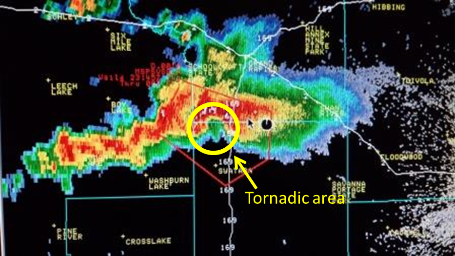
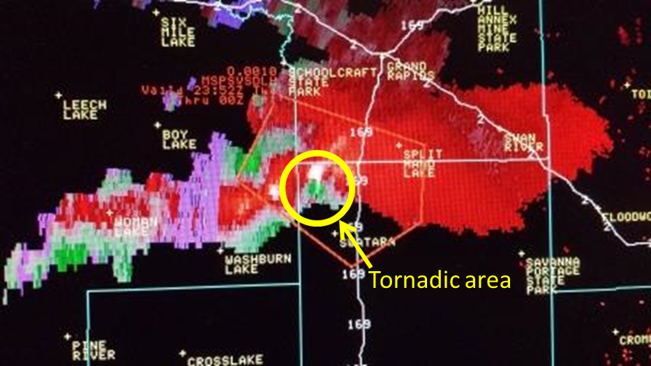
Track Map (Figure 3) 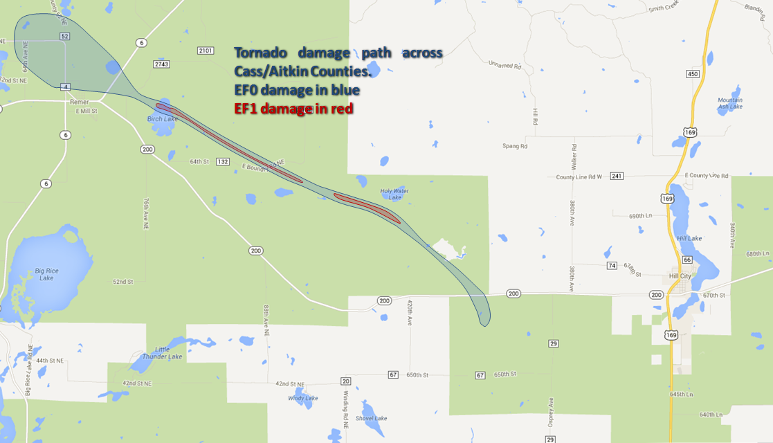 Track Map Including Wind and Hail Damage (Figure 2) 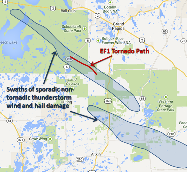 Overall Survey Area (Figure 1) 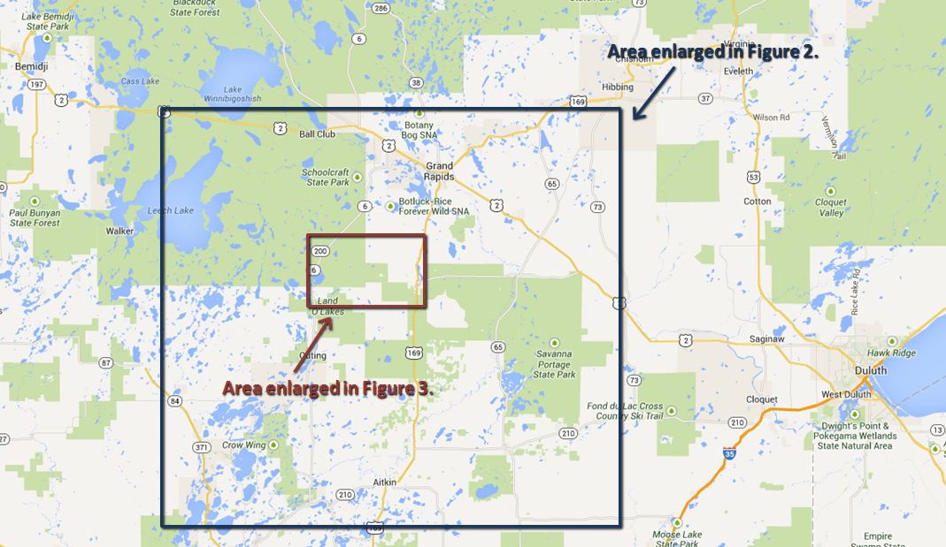 |
||||||||||||||||
The Enhanced Fujita (EF) Scale classifies tornadoes into the following categories:
| EF0 Weak 65-85 mph |
EF1 Moderate 86-110 mph |
EF2 Significant 111-135 mph |
EF3 Severe 136-165 mph |
EF4 Extreme 166-200 mph |
EF5 Catastrophic 200+ mph |
 |
|||||
 |
 |
 |
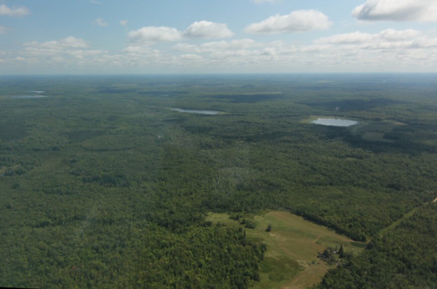
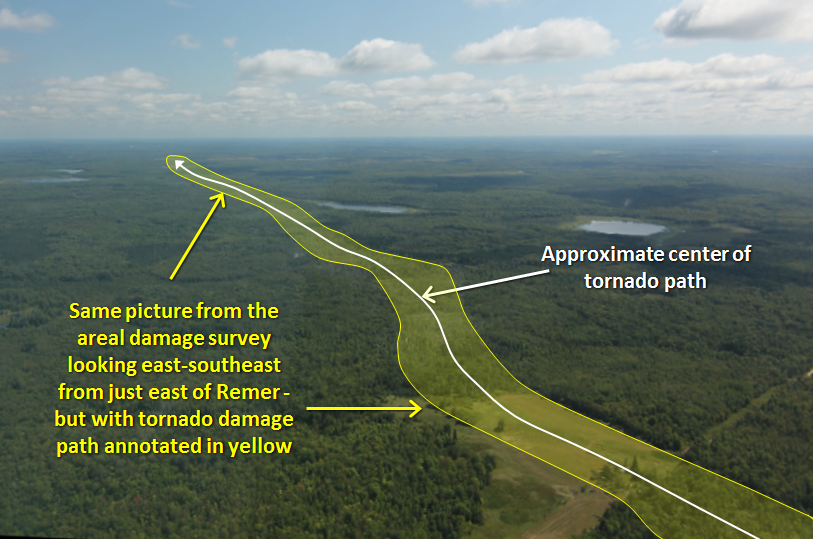
| Aerial photo of the tornado path | Annotated aerial view of the tornado path |
This home just north of Remer received substantial damage from fallen trees. Fortunately there was very little other damage to structures along the tornado's path. |
Skywarn Spotter Bob Conzemius took some great photos of the tornado which can be viewed here.
 |
 |
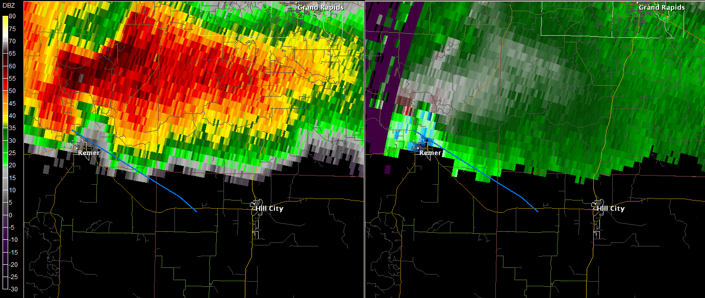 |
| 6:58 pm Reflectivity | 6:58 pm Storm Relative Velocity | The blue line is the rough tornado path. Reflectivity is on the left with storm relative motion on the right. |
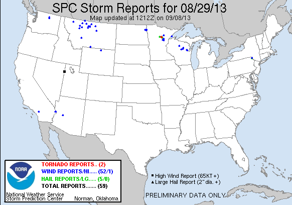
Click the image above for Storm Reports from around the country.
PUBLIC INFORMATION STATEMENT
NATIONAL WEATHER SERVICE DULUTH MN
945 PM CDT THU AUG 29 2013

..TIME...   ...EVENT...      ...CITY LOCATION...     ...LAT.LON...
..DATE...   ....MAG....      ..COUNTY LOCATION..ST.. ...SOURCE....
            ..REMARKS..

0606 PM     HAIL             1 N BOY LAKE            47.12N 94.15W
08/29/2013  M1.00 INCH       CASS               MN   TRAINED SPOTTER

0633 PM     TORNADO          2 E REMER               47.06N 93.87W
08/29/2013                   CASS               MN   TRAINED SPOTTER

            SPOTTER REPORTS BROAD, WEAK TORNADO. LOCATION ESTIMATED
            FROM SPOTTERS DESCRIPTION.

0638 PM     TORNADO          7 NW SWATARA            46.98N 93.77W
08/29/2013                   AITKIN             MN   TRAINED SPOTTER

            TORNADO SPOTTED JUST NORTH OF HIGHWAY 200

0643 PM     HAIL             1 SW HAYWARD            46.00N 91.50W
08/29/2013  M0.50 INCH       SAWYER             WI   TRAINED SPOTTER

0703 PM     HAIL             2 NW HILL CITY          47.01N 93.63W
08/29/2013  E1.75 INCH       AITKIN             MN   PUBLIC

            ON HIGHWAY 169. REPORT RELAYED VIA SOCIAL MEDIA. TIME
            ESTIMATED BY RADAR.

0707 PM     HAIL             N EARL                  45.91N 91.76W
08/29/2013  E0.75 INCH       WASHBURN           WI   PUBLIC

            PENNY TO DIME SIZED HAIL

0710 PM     HAIL             3 N HILL CITY           47.03N 93.60W
08/29/2013  E1.75 INCH       AITKIN             MN   PUBLIC

0712 PM     HAIL             3 S HILL CITY           46.94N 93.60W
08/29/2013  M1.00 INCH       AITKIN             MN   AMATEUR RADIO

0750 PM     HAIL             2 SE WINTER             45.80N 90.98W
08/29/2013  M0.25 INCH       SAWYER             WI   TRAINED SPOTTER

0759 PM     TSTM WND DMG     BIG SANDY LAKE          46.76N 93.29W
08/29/2013                   AITKIN             MN   LAW ENFORCEMENT

            SEVERAL TREES DOWN

0808 PM     HAIL             2 WSW SHESHEBEE         46.69N 93.28W
08/29/2013  E0.25 INCH       AITKIN             MN   TRAINED SPOTTER

0845 PM     TSTM WND DMG     1 S RICE LAKE           46.50N 93.37W
08/29/2013                   AITKIN             MN   PUBLIC

            SEVERAL PINE TREES DOWN. DIME SIZED HAIL ALSO REPORTED.

0910 PM     TSTM WND DMG     RICE LAKE               46.51N 93.37W
08/29/2013                   AITKIN             MN   TRAINED SPOTTER

            SEVERAL TREES UPROOTED.

0915 PM     HAIL             8 S PRENTICE            45.43N 90.29W
08/29/2013  M0.25 INCH       PRICE              WI   TRAINED SPOTTER


&&

$$
 |
Media use of NWS Web News Stories is encouraged! Please acknowledge the NWS as the source of any news information accessed from this site. |
|

