Heavy Snow & Arctic Outbreak
March 9th-11th, 2009
Overview
|
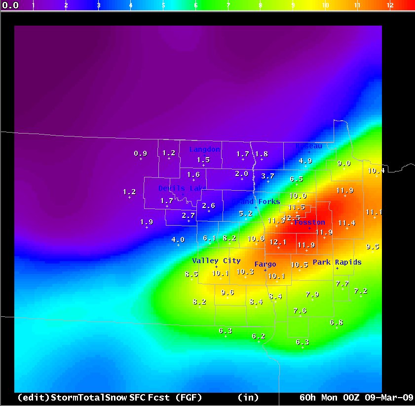
Storm Recap from the Minnesota State Climatology Office: A rapidly deepening area of low pressure moved from eastern Iowa to the Upper Peninsula of Michigan during the day on Tuesday, March 10. A mixed bag of rain and snow fell over southern and parts of central Minnesota, including the Twin Cities. Heavy snow fell over western and northern Minnesota, with blizzard conditions in the Red River Valley. These conditions forced the closure of highways, including I-94 from Jamestown, North Dakota to Fergus Falls. The highest snowfall reported was 18.8 inches at International Falls, but this includes a secondary storm that happened on March 9th. Fargo picked up more unwanted precipitation with 10.1 inches of snow (.78 inches of melted precipitation) on March 9th and 10th. As the winter storm swept into Ontario on March 11, northwest winds continued throughout the day with bitterly cold air entrenched across Minnesota. The coldest wind chill found on March 11 was -36 degrees at 7am in Bemidji. The Twin Cities had a minimum temperature of -4 on March 12. While not a record, the last time it dipped to zero or colder so late in a winter season in the Twin Cities was March 15, 1997. Embarrass and Babbitt reached -35 below zero on March 12, setting a new coldest record low for Minnesota for March 12. The old record was -34 set at Ada in 1896. |
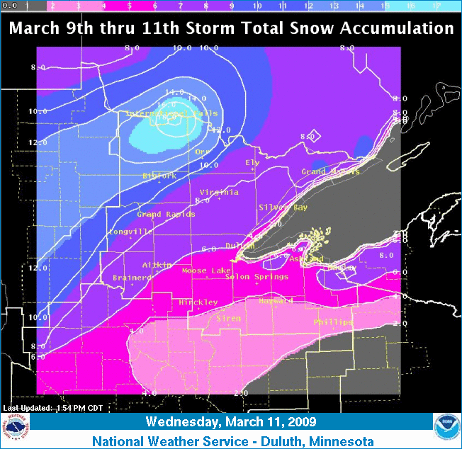 Created by Duluth NWS Office |
 |
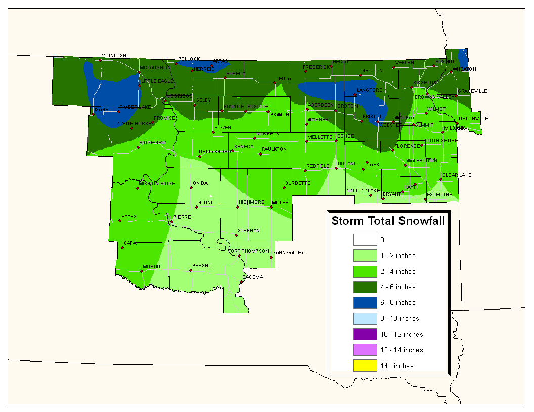 |
| Created by Grand Forks NWS Office | Created by Aberdeen NWS Office |
Snow Reports
000
NOUS43 KDLH 111649
PNSDLH

PUBLIC INFORMATION STATEMENT
NATIONAL WEATHER SERVICE DULUTH MN
1141 AM CDT WED MAR 11 2009


THE TOTALS BELOW ARE STORM TOTAL SNOW ACCUMULATIONS THAT BEGAN IN
AREAS OF CENTRAL AND NORTH CENTRAL MINNESOTA TUESDAY MORNING. DATA
WAS COLLECTED BY A DEDICATED NETWORK OF COOPERATIVE WEATHER
OBSERVERS AND SNOW SPOTTERS.


SNOW REPORTS LISTED BY AMOUNT

 INCHES  LOCATION                 ST  COUNTY           TIME
 ------  -----------------------  --  --------------   -------
 18.80   INTERNATIONAL FALLS      MN  KOOCHICHING      0700 AM
                 STORM TOTAL
 16.20   KABETOGAMA               MN  ST. LOUIS        0700 AM
                 STORM TOTAL
 15.70   LITTLEFORK               MN  KOOCHICHING      0800 AM
                 STORM TOTAL
 14.00   DIXON LAKE               MN  ITASCA           0800 AM
 12.60   3 E ORR                  MN  ST. LOUIS        0800 AM
 11.00   GRAND PORTAGE            MN  COOK             0800 AM
 11.00   3 E ORR                  MN  ST. LOUIS        0600 AM
 10.80   NORTHOME                 MN  KOOCHICHING      0800 AM
                 STORM TOTAL
  9.50   15 NW GRAND MARAIS       MN  COOK             0900 AM
  9.00   6 NW GRAND MARAIS        MN  COOK             0800 AM
  9.00   1 SW TOFTE               MN  COOK             0800 AM
  8.80   8 S BIGFORK              MN  ITASCA           0800 AM
                 STORM TOTAL
  8.50   LUTSEN                   MN  COOK             0730 AM
  8.30   LOON LAKE                MN  COOK             0730 AM
  8.00   2 ENE HOVLAND            MN  COOK             0800 AM
  8.00   REMER                    MN  CASS             0800 AM
  8.00   EMBARRASS                MN  ST. LOUIS        0600 AM
                 0.63 LIQUID EQUIVALENT.
  7.80   BAYFIELD                 WI  BAYFIELD         0700 AM
  7.30   FEDERAL DAM              MN  CASS             0800 AM
                 STORM TOTAL
  7.00   6 NE CLOVERLAND          WI  DOUGLAS          0730 AM
  7.00   COTTON                   MN  ST. LOUIS        0715 AM
  6.60   OULU                     WI  BAYFIELD         0730 AM
  6.50   PEQUOT LAKES             MN  CROW WING        0900 AM
  6.50   BRAINERD                 MN  CROW WING        0730 AM
  6.30   MAPLE                    WI  DOUGLAS          0715 AM
  6.30   DULUTH                   MN  ST. LOUIS        0700 AM
                 DULUTH NWS FORECAST OFFICE...24-HOUR TOTAL.
  6.20   MARCELL                  MN  ITASCA           0800 AM
  6.20   5 NE ASKOV               MN  PINE             0730 AM
  6.10   15 N GRAND RAPIDS        MN  ITASCA           0600 AM
                 STORM TOTAL
  6.00   SAGINAW                  MN  ST. LOUIS        0800 AM
  6.00   CROSSLAKE                MN  CROW WING        0800 AM
  6.00   LITTLE MARAIS            MN  LAKE             0800 AM
  5.90   NORTHOME                 MN  KOOCHICHING      0800 AM
  5.50   3 NE NISSWA              MN  CROW WING        0830 AM
  5.50   8 NE COOK                MN  ST. LOUIS        0600 AM
                 STORM TOTAL
  5.30   LEECH LAKE               MN  CASS             0800 AM
  5.30   5 NW WASHBURN            WI  BAYFIELD         0800 AM
  5.00   CULVER                   MN  ST. LOUIS        0900 AM
  5.00   6 SW TWO HARBORS         MN  LAKE             0830 AM
  5.00   ENE GRAND MARAIS         MN  COOK             0800 AM
  5.00   2 SSW STURGEON LAKE      MN  PINE             0800 AM
  5.00   MOOSE LAKE               MN  CARLTON          0730 AM
  4.80   12 N ISLE                MN  AITKIN           0730 AM
  4.60   KERRICK                  MN  PINE             0600 AM
  4.50   7 NW BENNETT             WI  DOUGLAS          1000 AM
  4.50   BENNETT                  WI  DOUGLAS          0800 AM
  4.50   GURNEY                   WI  IRON             0800 AM
  4.30   WASHBURN                 WI  BAYFIELD         0730 AM
  4.00   CLOQUET                  MN  CARLTON          1015 AM
  4.00   TRADE LAKE               WI  BURNETT          1015 AM
  4.00   SAXON                    WI  IRON             0800 AM
  3.50   NNW KNIFE RIVER          MN  LAKE             0800 AM
  3.30   HAYWARD                  WI  SAWYER           0600 AM
  3.00   HURLEY                   WI  IRON             0800 AM
  3.00   HERTEL                   WI  BURNETT          0730 AM
  2.50   PARK FALLS               WI  PRICE            0800 AM
  2.50   GORDON                   WI  DOUGLAS          0800 AM
  2.00   BUTTERNUT                WI  ASHLAND          0600 AM
  1.50   4 W CLAM LAKE            WI  BURNETT          0800 AM

$$
Extreme Cold
000
NOUS43 KDLH 121947
PNSDLH

PUBLIC INFORMATION STATEMENT
NATIONAL WEATHER SERVICE DULUTH MN
235 PM CDT THURSDAY MAR 12 2009

A NEW STATE RECORD DAILY LOW TEMPERATURE WAS SET IN MINNESOTA THIS
MORNING.  THE PREVIOUS STATE RECORD LOW TEMPERATURE FOR MARCH 12TH
WAS SET IN 1896 AT THE TOWN OF ADA WHICH REPORTED -34 DEGREES.
EMBARRASS AND BABBIT BOTH REPORTED -35 DEGREES THIS MORNING MARCH
12, 2009.

THE FOLLOWING IS A SAMPLE OF THE COLD TEMPERATURES FROM ACROSS THE
AREA THIS MORNING.


NORTHEASTERN MINNESOTA

                                    MIN
EMBM5: EMBARRASS............COOP:   -35
BABM5: BABBIT...............COOP:   -35
XVG  : LONGVILLE............AWOS:   -33
LEIM5: ORR 3E...............COOP:   -30
FLDM5: FLOODWOOD 3W.........COOP:   -30
FOZ  : BIGFORK..............AWOS:   -29
CDD  : CRANE LAKE...........AWOS:   -29
INL  : INTERNATIONAL FALLS..ASOS:   -28
PWC  : PINE RIVER...........AWOS:   -27
HIB  : HIBBING ARPT.........ASOS:   -27
NOHM5: NORTHOME.............COOP:   -27
BRD  : BRAINERD.............ASOS:   -25
MZH  : MOOSE LAKE...........AWOS:   -24
GPZ  : GRAND RAPIDS.........AWOS:   -24
EVM  : EVELETH..............AWOS:   -24
AIT  : AITKIN...............AWOS:   -24
HCKM5: HINCKLEY.............COOP:   -24
CRLM5: CROSS LAKE DAM.......COOP:   -24
BRUM5: BRUNO................COOP:   -24
KABM5: KABETOGAMA...........COOP:   -22
GLLM5: GULL LAKE DAM........COOP:   -22
CSLM5: CASS LAKE............COOP:   -22
ORB  : ORR..................AWOS:   -20
ELO  : ELY..................AWOS:   -20
COQ  : CLOQUET..............AWOS:   -20
CKC  : GRAND MARAIS.........AWOS:   -20
GNFM5: GUNFLINT LAKE 10NW...COOP:   -20
TWM  : TWO HARBORS..........AWOS:   -18
CQM  : COOK.................AWOS:   -18
COKM5: COOK 8NE.............COOP:   -18
HZX  : MCGREGOR.............AWOS:   -17
GNA  : GRAND MARAIS MN......ASOS:   -17
BFW  : SILVER BAY...........AWOS:   -17
PKGM5: POKEGAMA DAM.........COOP:   -17
WLFM5: WOLF RIDGE ELC.......COOP:   -15
DLH  : DULUTH AIRPORT.......ASOS:   -14

STATE RECORD TEMPERATURE INFORMATION WAS PROVIDED BY THE MINNESOTA
CLIMATOLOGY WORKING GROUP HTTP://CLIMATE.UMN.EDU.

$$
Additional Information
Summaries from other NWS Offices
 |
Media use of NWS Web News Stories is encouraged! Please acknowledge the NWS as the source of any news information accessed from this site. |
|

