
20 Year Anniversary Video:
Event Summary:
For a detailed summary of the atmospheric conditions and meteorology, click here! (courtesy of NWS Ft. Worth, TX)
A deadly severe weather episode unfolded across portions of Central Texas during the afternoon and evening hours on Tuesday, May 27th, 1997. This event was made infamous by one of the most powerful tornadoes on record: an F5 which tore through a subdivision of Jarrell called Double Creek Estates in extreme northern Williamson County during the mid-afternoon. Some of the most extreme damage on record occurred with this tornado, and one account states that “the earth was scoured bare, pavement was ripped from roadways, [and] homes and other buildings were completely pulverized” (Lon Curtis, Weather Bulletin). Two tornadoes also touched down in the Austin Metro area: an F3-rated tornado in Cedar Park and an F4-rated tornado near Lakeway.
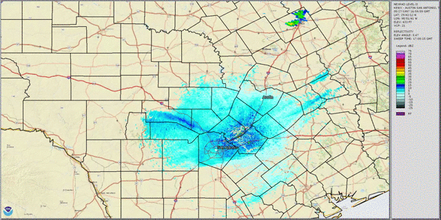 May 27,1997 Radar Loop |
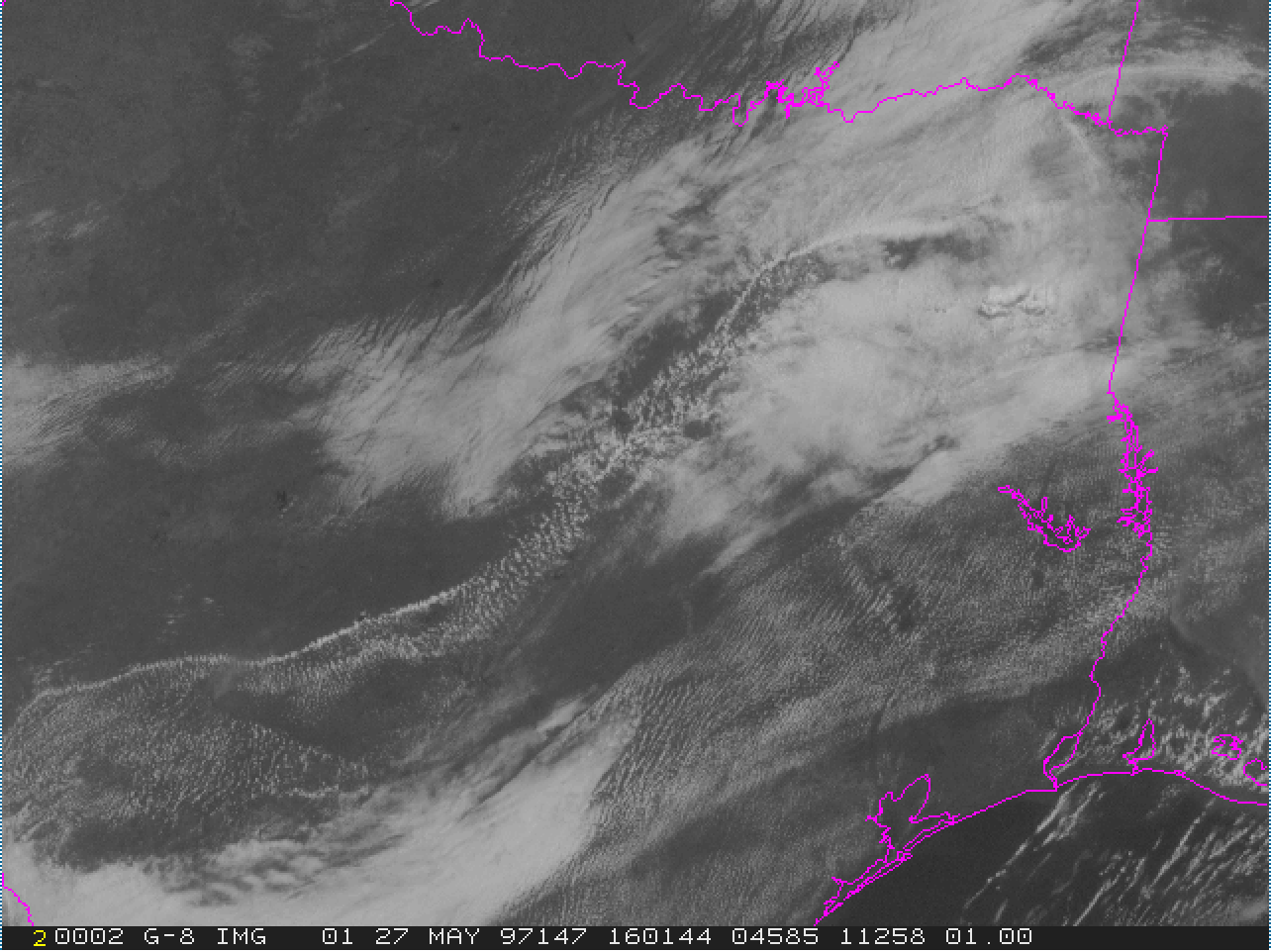 Visible Satellite Animation |
This event was additionally unusual because of the notable lack of upper-level forcing for ascent (lift), and generally light winds through the troposphere--where our weather occurs. In a sense, this day was distinctly lacking two of the four crucial ingredients we typically look for on big severe weather events (strong lift and wind shear, especially near the surface). Yet, over the course of roughly six hours, 20 tornadoes touched down across the Dallas/Fort Worth and Austin/San Antonio forecast areas of responsibility.
Jarrell Tornado:
Several eyewitnesses reported that the Jarrell tornado was preceded for a period of 8 to 10 minutes by a series of short-lived very small tornadoes that formed from the same supercell thunderstorm. These touched down, then dissipated in order.
The first tornado in Williamson County formed near 3:25 pm CDT and built rapidly to F2 strength. It survived for approximately 8 minutes, often returning briefly to a roped and tilted feature before it died. This tornado was followed by a second that formed near 3:35 pm CDT. It built quickly into a multi-vortex tornado that appeared to be near F2 strength as well. This dissipated after only 4 minutes.
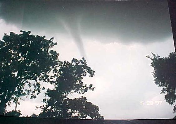
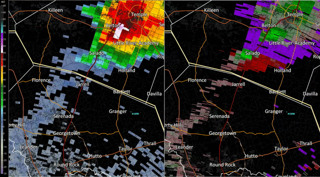 The final tornado from this same supercell, the Jarrell Tornado, developed as a small, rope-shaped tornado, touching down around 3:40 pm CDT inside the Williamson County line northwest of Jarrell. From film and eyewitness accounts, it expanded quickly into a very large vortex nearly 1/2 mile in width. Observations recounted by eyewitnesses indicated that the damage path may not have been made strictly by one tornado. A number of eyewitnesses reported seeing several small, rope-like funnels before the character of the tornado changed drastically into the killer tornado. Ground damage patterns in the Double Creek Subdivision also suggested this possibility.
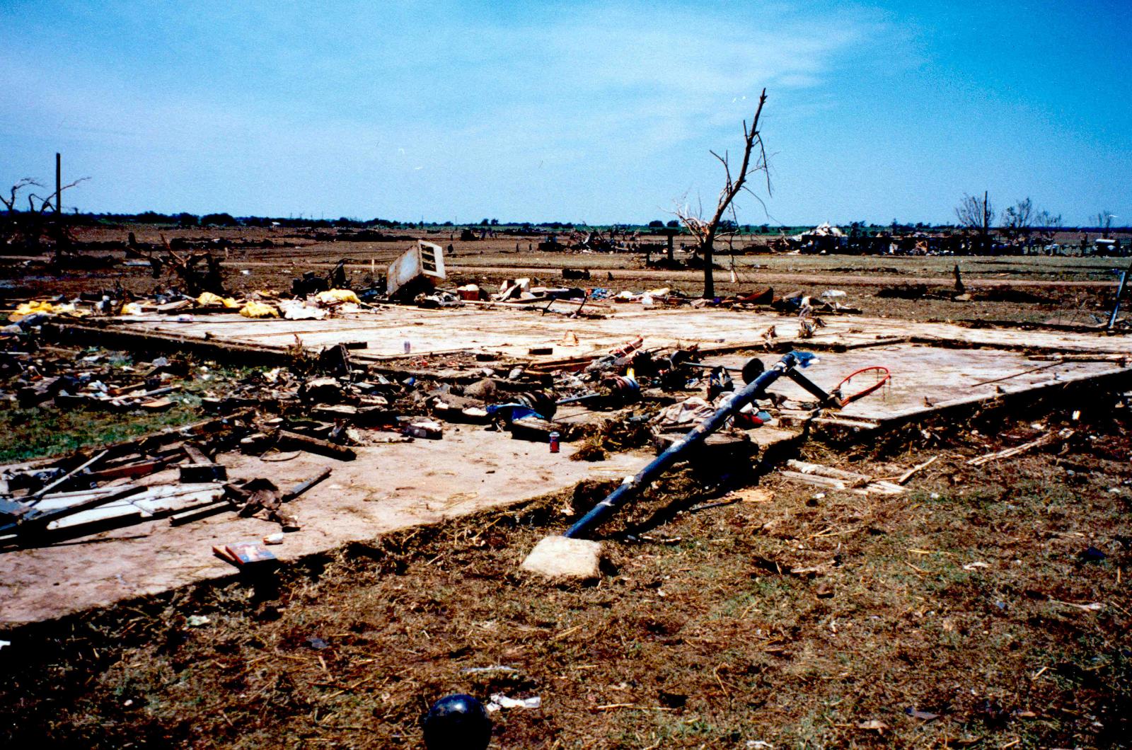
The tornado crossed CR 308, CR 305, and then CR 307. Where the tornado crossed each of these county roads, approximately 525 feet of asphalt was ripped off each of the roadways. This particular destruction was believed to be very close to the centerline of the tornado circulation. As the tornado crossed the intersection of CR 305 and 307, a business on the corner was destroyed. The tornado moved into the Double Creek area at this point with total destruction. F5 destruction continued from shortly after its formation until very close to the end of the damage path.
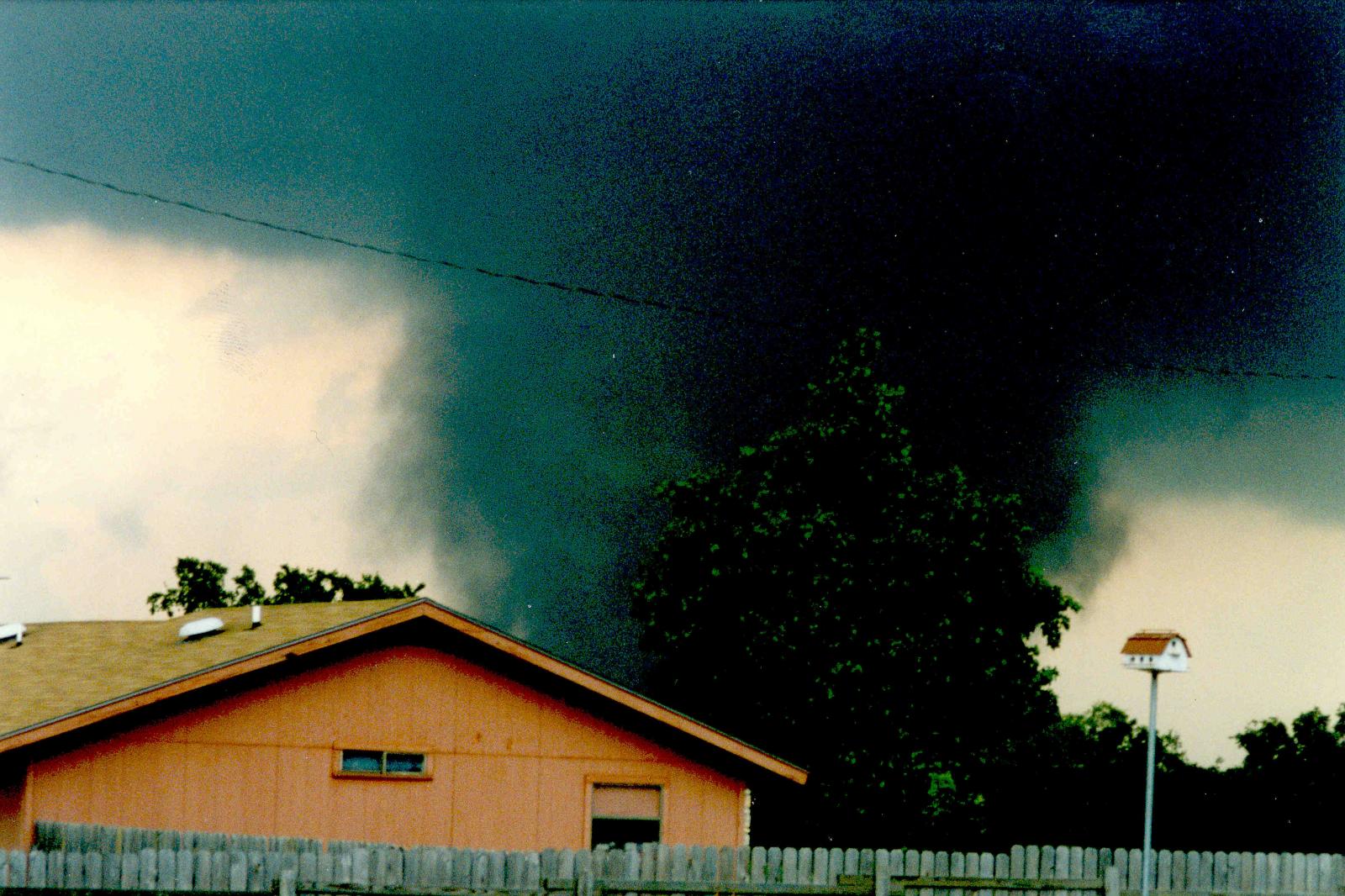 The tornado began a brief turn toward the southeast as it entered the Double Creek subdivision and the surrounding area, moving very slowly. It reached the subdivision at 3:48 pm CDT. This time is based on a clock found at a destroyed residence in the extreme northwest corner of the subdivision and the home believed to be the first struck by the tornado. Here, it widened to it maximum width of three-quarters of a mile. From the air, the ground appearance changed abruptly in the vicinity of CR 308 and continued until very near the end of the path. No definitive circulation patterns or suction spots were evident, but there was the noted obvious change in the appearance of the ground.
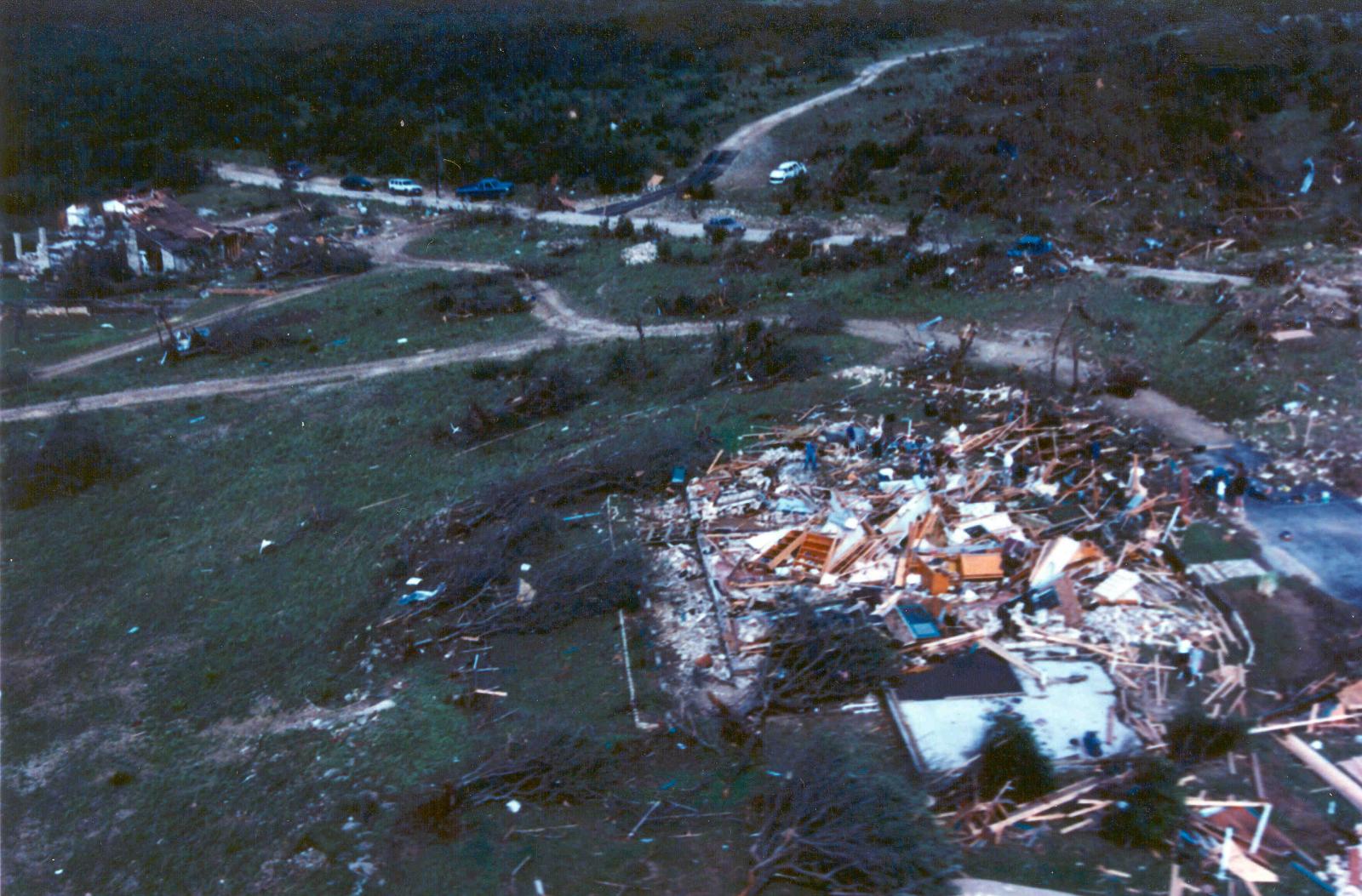
In the Double Creek area, approximately 40 structures were totally destroyed. One of the most striking signs in approaching this area was the distinct lack of debris of any size. Closer inspection showed lots of little debris but no sign of large items. It was estimated that several dozen vehicles had been in the subdivision and removed by the tornado. Nearly 300 cattle grazing in a pasture near the subdivision were also killed, with many of them tossed and blown for over 1/4 mile. At least half a dozen cars were identified from the air lying in the open areas, most of them flattened and encrusted with mud and grass. Trees in the subdivision were completely stripped of bark. Later ground survey revealed that most of the debris that was left in the area was extremely small indicating the power of the tornadic wind. All 27 deaths associated with the Jarrell tornado occurred in the Double Creek area. Eyewitnesses reported that it appeared to have slowed down as it entered the subdivision, and that may account for the nearly total destruction that took place.
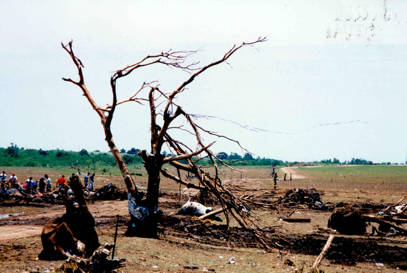
After passing through the Double Creek area, the tornado shifted its track again slightly, moving toward the south-southwest across CR 309 and into a heavily wooded area of cedar trees. The total destruction of the tornado ends abruptly shortly after entering the wooded area. However, a small swath of tree damage on the north side of the main damage path suggested the possibility of a multiple vortex pattern. No other evidence of multiple vortices was observed.
The sequence of weather phenomenon reported with this tornado was exactly opposite of that often reported- the tornado first appeared, followed by nearly calm conditions, then hail, followed by rain and finally brief, gusty winds. This is attributed to the fact that the parent supercell was moving toward the southwest for most of its life. The storm essentially "backed into" the area as it moved.
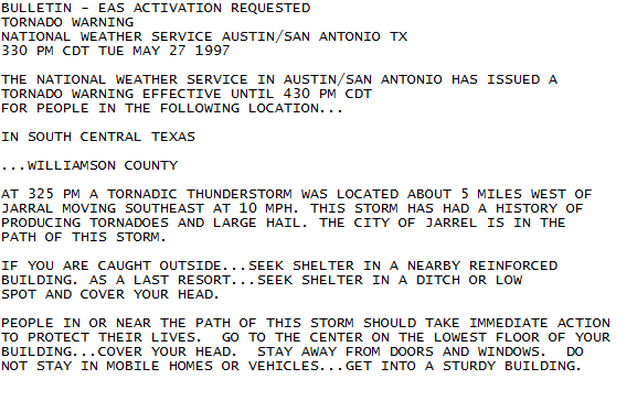
(Below): Tornado Warning issued by National Weather Service Austin / San Antonio for Jarrell
Cedar Park Tornado:
 The Cedar Park tornado formed around 4:05 pm CDT from a different supercell thunderstorm. It first touched down about 3.5 miles north of Cedar Park at a location 0.6 miles south of CR 178 and 1.4 miles east of the intersection of US 183 and CR 178. The initial damage was to trees, however, the ground survey revealed damage nearby to a church and a trucking company. The aerial survey did not reflect this damage as being in line with the damage path. It is quite possible this damage was caused by strong wind near the tornado. The beginning point was in a relatively open area with damage primarily to a few trees and minor shingle damage to one house.
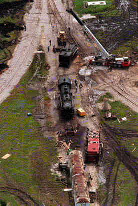
The tornado moved south-southwestward skirting a residential area before it crossed CR 180 immediately east of US 183. A historic train located on the north side of CR 180 just to the east of US 183 was in the direct path of the tornado. While the engine remained on the track, a coal tender converted to hold diesel fuel and weighing approximately 65,000 pounds including the 1,000 gallons of diesel fuel was flipped over and thrown a short distance.
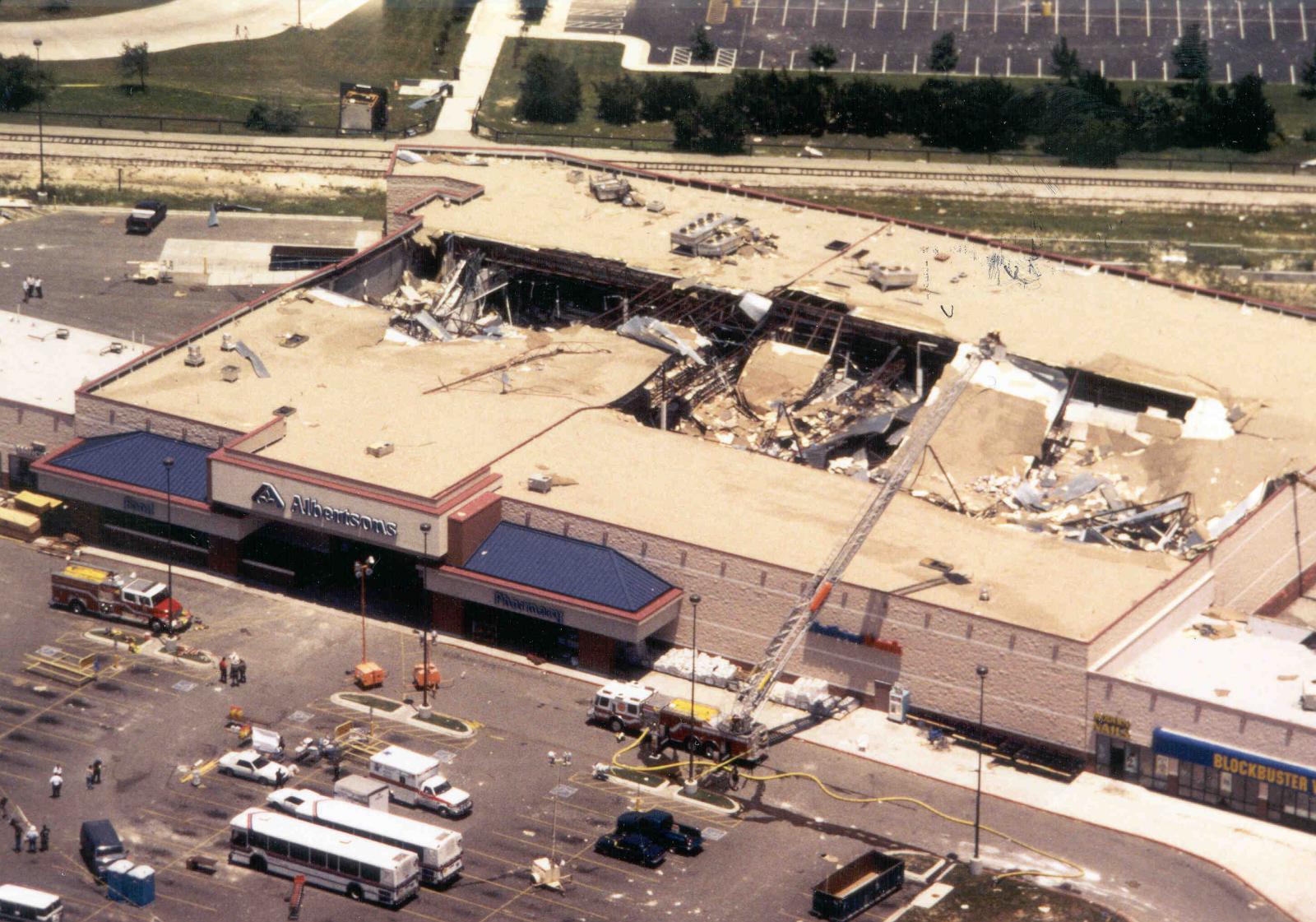 Continuing across CR180, it entered a shopping center where it weakened and pushed inward slightly the north wall of a grocery store. It also pushed large metal doors inward that were built to open toward the outside. Damage at this point had been generally F2 with brief F3 as the tornado knocked the train tender off the track and damaged the wall and doors of the food store. It tore off much of a weakly supported roof of a grocery store. The manager of the store, who had been a victim of the Wichita Falls Tornado of 1979, saw the approaching tornado, and made an announcement to all in the store to meet him in the middle of the store. He then led everyone he could gather into the meat locker. This very quick and decisive action probably saved several lives.
The tornado crossed US 183 causing additional damage to a number of businesses. One business on the west side of US 183 lost nearly the entire roof. Most damage to other businesses was believed to be minor. After crossing US 183 the tornado moved across Marquis Lane and North Park Circle moving through an area with widely scattered housing and a relative abundance of trees. Again, most damage to structures in this area was minor.
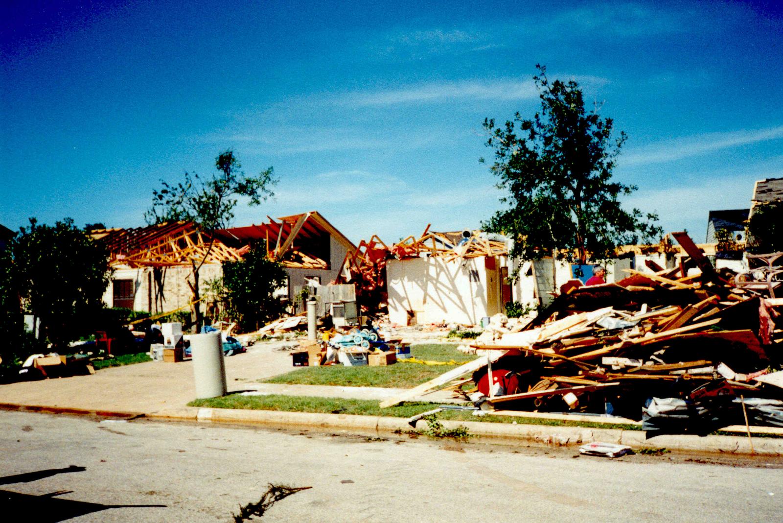 From North Park Circle the tornado moved into the northwestern portion of Buttercup Creek, a subdivision of well constructed homes. Damage to homes was irregular with one house losing a roof but the house next door losing only shingles. Two homes in the area were nearly destroyed an one damaged when a pickup truck was lifted and tossed against its front wall. Eleven homes were destroyed, with damage reported to over 100 homes. The damage level ranged from F0 to F2. At this point, the tornado track was taking a gentle right turn as the tornado track became more southwesterly. The tornado moved into a wooded area crossing into Travis County before ending 1.1 miles from Lake Travis. Damage in the wooded area was irregular ranging from near total destruction of all trees to sections with about 10 percent of the trees down.
Lakeway/Pedernales Valley Tornado:
The Pedernales Valley tornado began on the shore of Lake Travis destroying trees and a floating marina where nearly all of the watercraft were destroyed. While numerous trees were twisted and uprooted in this area, several structures sustained only what appeared to be minor damage that would be no more than F0. The tornado was initially moving westward as it moved into rough terrain. A number of structures sustained varying damage until the tornado reached Bee Creek Road. At that location, a Southwest Bell building housing telephone switching equipment was destroyed. The building was well constructed and was one of several buildings which indicated at F4 rating for this tornado. Bee Creek Road takes a bend close to the telephone building and across the street a house was destroyed with walls knocked down.
 Approximately 2.2 miles from the lake, the tornado path takes a distinct dog leg turn toward the southwest. The point at which this dog-leg turn occurred also corresponds with a knoll. Trees and buildings at the top of the knoll were destroyed. After the dog-leg turn, the tornado assumed a heading of 250 degrees and crossed a major power distribution line. One steel tower was destroyed bringing all lines to the ground. The tornado remained on the 250 degree heading moving through the area described as the Hazy Hills subdivision. Numerous houses and several mobile homes were totally destroyed. Several houses survived but sustained major damage making them totally uninhabitable.
The only death associated with this tornado occurred here when one man was killed. He lived in a mobile home that was demolished and his vehicle was tossed several hundred feet. Other survey team members were unable to learn whether he was in the mobile home or had left it to drive away.
The tornado continued west-southwest moving across State Road (SR) 71. A number of well built homes in the Hazy Hills subdivision were heavily damaged or destroyed. Crossing SR 71, the tornado moved into another subdivision with widely separated houses in the Lick Creek valley, a steep walled creek that feeds into the Pedernales River. One stone-walled house located just north of Pedernales Drive and west of SR 71 was completely de-roofed. Other structures in this subdivision sustained roof damage in the F2 range. After following the terrain into the creek it climbed another rise in the land before ending shortly after passing the crest of the small hill. As the tornado ended, damage was minimal to trees.
Mr. Troy Kimmel
Mr. Scott Beckwith
Ms. Vancil
Mr. Jeff Draper & The Texas Severe Storm Intercept Team
NWS Ft. Worth, TX


