Lake of the Woods - UNDER CONSTRUCTION
For an explanation on how to use this page click here
These special weather statements apply to location specific special weather statements for impactful weather on/near Lake of the Woods. They can include localized blizzard conditions on the lake, or lake effect snow bands off of Lake of the Woods.
|
|
|
|
|
|
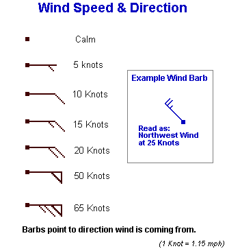
Notice:Wave height forecasts represent the average of the highest one-third (33%) of waves (measured from trough to crest) that occur in a given period. Since the Significant Wave Height is an average of the largest waves, mariners should be aware that many individual waves will probably be higher.
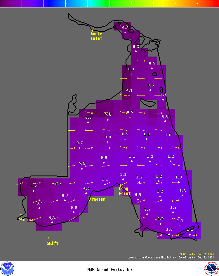
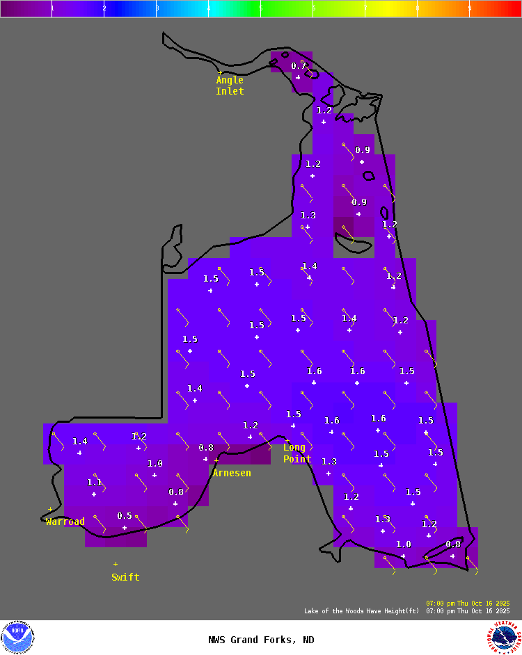
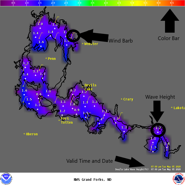
Instructions: On the image below, click on the right & left arrows to advance forward & backward in time. The time and date of the forecast will be in the bottom right of the image.
Lake info and Help.
This page will explain how to use the Lake Wave Forecasts Page.
Three lakes are covered by our Lake Wave Forecasts Page: Devils Lake, the Upper and Lower Red Lakes, and Lake of the Woods. The forecasts cover both the wind (speed and direction) and wave height. There are two sections of the Lake Wave Forecast Page:
While we only make these forecasts for the larger lakes you can apply the forecasts to nearby lakes as well. A high wave day on the larger lakes means the potential for higher waves on the smaller lakes. Smaller lakes will be more sheltered with less fetch so the waves will not be as high as the larger lakes.
Notice: Wave height forecasts represent the average of the highest one-third (33%) of waves (measured from trough to crest) that occur in a given period. Since the Significant Wave Height is an average of the largest waves, mariners should be aware that many individual waves will probably be higher.
Lake Recreation Forecasts.
324

SXUS43 KFGF 130940

RECFGF


Recreation Forecast

National Weather Service Grand Forks ND

440 AM CDT Mon Oct 13 2025


Here are the Recreation Area Forecasts...


Wave height forecasts represent the average of the highest 33% of

waves that occur in a given period. Since the significant wave

height is an average of the largest waves, mariners should be

aware that many individual waves will be higher.


For Devils Lake...


.TODAY...Very windy. West winds 30 to 45 mph becoming northwest

10 to 20 mph. Waves 2 to 4 feet. Mostly cloudy early in the

morning then clearing. Highs 45 to 55.

.TONIGHT...Northeast winds 10 to 15 mph. Waves 1 foot or less.

Partly cloudy. Lows in the upper 20s.

.TUESDAY...Southeast winds 10 to 15 mph. Waves 1 foot or less.

Mostly cloudy. Highs in the 40s.


For the Upper and Lower Red Lakes...


.TODAY...Windy. West winds 25 to 35 mph decreasing to 10 to

20 mph in the afternoon. Waves 3 to 6 feet. Partly cloudy early

in the morning then clearing. Highs 45 to 55.

.TONIGHT...North winds 10 to 15 mph. Waves 1 to 2 feet subsiding

to 1 foot or less after midnight. Partly cloudy. Lows in the mid

30s.

.TUESDAY...Northeast winds around 10 mph in the morning becoming

light. Waves 1 foot or less. Mostly cloudy. Highs 45 to 55.


For Lake of the Woods...


.TODAY...Very windy. West winds 30 to 45 mph decreasing to 15 to

25 mph. Waves 3 to 6 feet. Mostly cloudy early in the morning

then becoming mostly sunny. Highs in the 40s.

.TONIGHT...Northwest winds 10 to 20 mph. Waves 2 to 4 feet.

Partly cloudy. Lows in the mid 30s.

.TUESDAY...North winds around 10 mph early in the morning

becoming light. Waves 1 to 2 feet subsiding to 1 foot or less in

the afternoon. Partly sunny. Highs in the 40s.


$$


