Extreme Heat in the Southwest; Severe Weather in the Northern Plains; Heavy Rain in the East
Extreme heat continues across the Southwest as temperatures may top 120 degrees. The heat may expand across the West and south-central U.S. into the middle of the month. Severe thunderstorms capable of severe wind gusts and large hail will be the primary hazards today across the northern Plains into the upper Midwest. Rainfall could be locally heavy across the Eastern U.S. today.
Read More >
Changed addresses or phone numbers recently? Contact by
sending
an email to or by calling .
SKYWARN Storm Spotter Training
SKYWARN is a program that trains volunteers to help keep their local communities safe by providing timely and
accurate reports of monsoon season weather to the National Weather Service. In the program you’ll learn
about:
The basics of thunderstorm development
The fundamentals of storm structure
Identifying potential severe weather features
How to report severe weather
Basic severe weather safety
In-person training sessions are listed below. They are free and
there
is no need to RSVP!
Date
Time
Location
Address
Loading schedule...
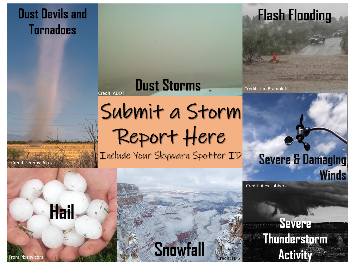
Two Options to Submit Reports: Phone or Online (click image below)
If submitting a report by phone (888-745-1637), it is crucial to tell us
WHEN and WHERE the significant weather event occurred. For geographic
reference, an intersection and town are invaluable so we can pinpoint the report. If it's a second or
third
hand report, please give us the source of the original report, along with all the applicable information
about
what was reported.
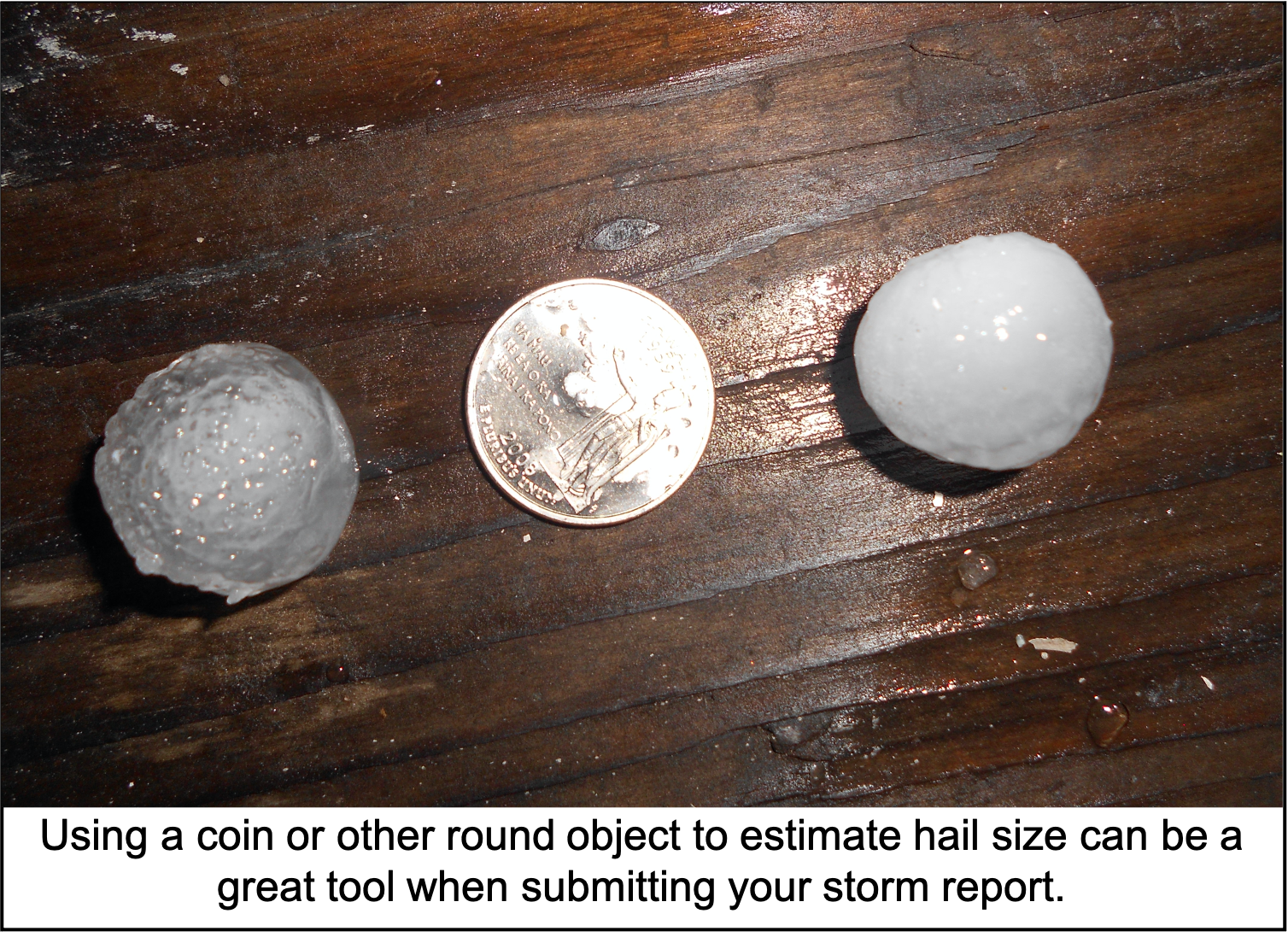
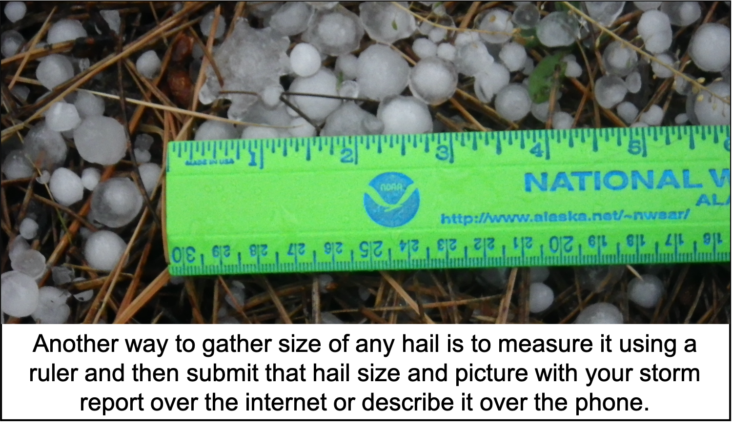
Hail Size Reporting Reference
Please report the size of the largest hailstones as they cause the most damage.
Also,
please do not use the term "marble size" or "ice cube" since these items come in
many
different sizes.
0.25 inch - Pea
0.50 inch - Dime
0.75 inch - Penny
0.88 inch - Nickel
1.00 inch - Quarter (Severe)
1.25 inch - Half Dollar (Severe)
1.50 inch - Ping-Pong (Severe)
1.75 inch - Golf Ball (Severe)
2.00 inch - Hen Egg (Severe)
2.50 inch - Tennis Ball (Severe)
2.75 inch - Baseball (Severe)
3.00 inch - Tea Cup (Severe)
4.00 inch - Grapefruit (Severe)
4.50 inch - Softball (Severe)
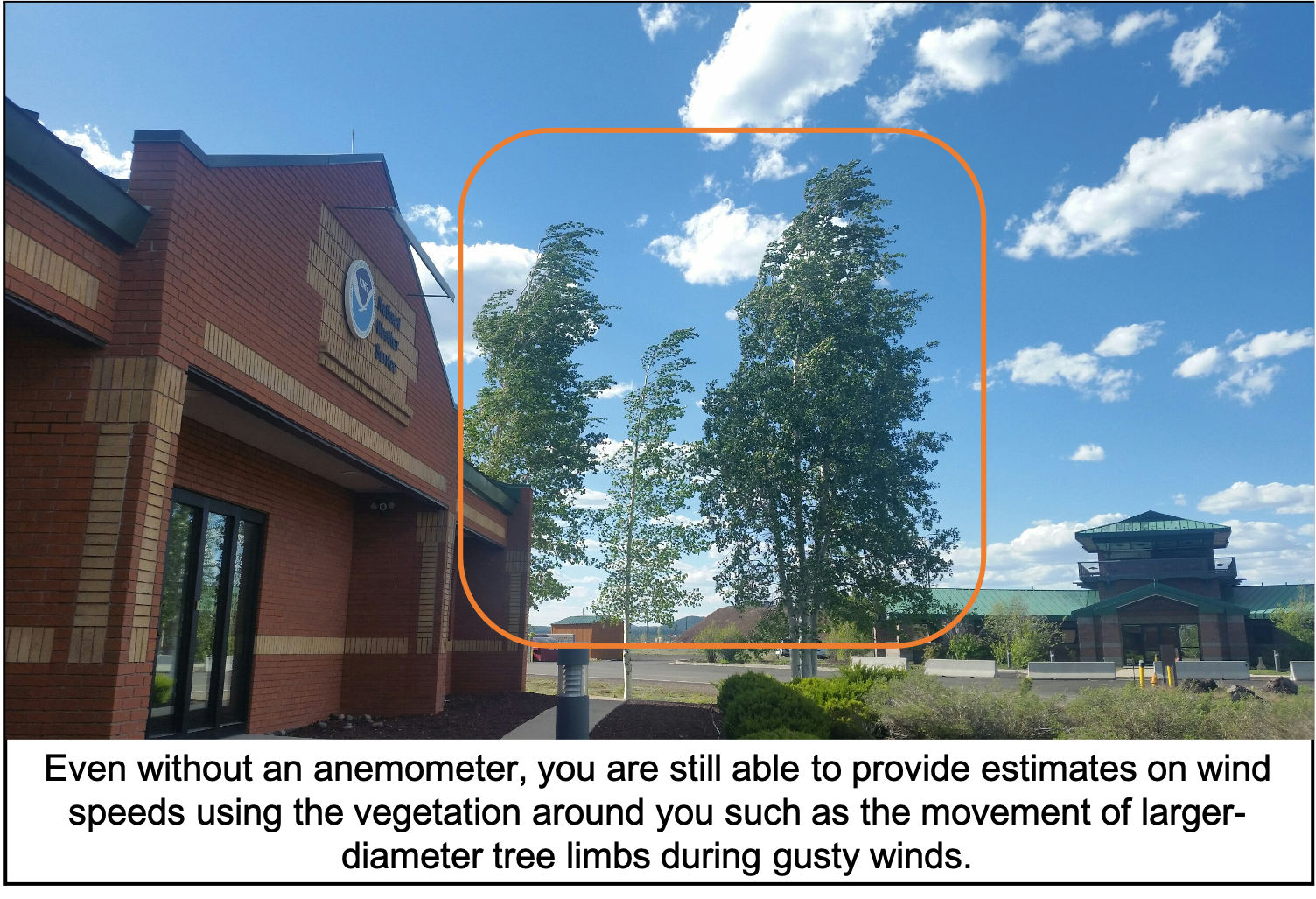
Wind Speed Reporting Reference
Please report both the estimated wind speed based on the vegetation (see
descriptions
below) and also any damage or impacts to life and property caused by strong to severe winds.
25-31 mph: Large branches in motion; whistling heard in power lines.
32-38 mph: Whole trees in motion; inconvenience felt walking into the wind.
39-57 mph: Twigs break off trees; wind generally impedes progress; garbage cans blow over.
58-72 mph (Severe): Shallow-rooted trees blown over; trampolines can flip over; sheds and pole barns
can
sustain damage; downed power lines are possible.
73-112 mph: Surface of roofs peeled away; windows broken; mobile homes pushed or overturned; moving
cars
pushed off roads.
Remember, you are a storm spotter, not a storm chaser! Only submit a storm report if you
are
in a safe location and situation to do so, never put yourself in harms way to submit a storm report.
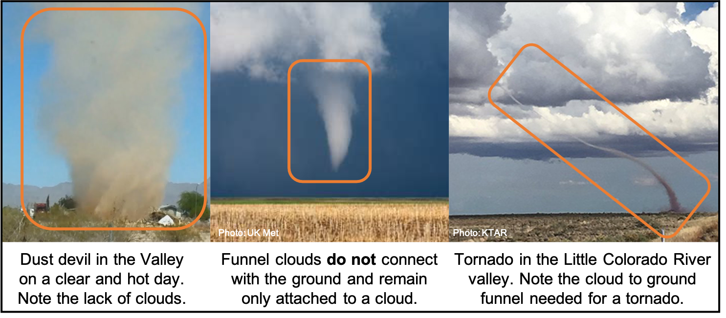
Dust Devil versus Funnel Cloud versus Tornado
Dust Devil - Generally forms on a hot and clear day, typically in the afternoon to early evening
time
period. Dust Devils are in contact with the ground, but never a cloud and can last on the scale
of
seconds to tens of minutes.
Funnel Cloud - Rotating column of air that extends from the base of the cloud but does not make
contact
with the ground. These are commonly spotted during the northern Arizona monsoon season or during
the
early fall season when strong cold fronts can push across the Southwest.
Tornado - Rotating column of air that extends from a cloud to the ground. Tornadoes have been
known
to form in both the monsoon season and be associated with strong cold fronts that cross over the
Southwest during the early to late fall time period.
Dust Storm - While more rare in northern Arizona compared to the lower elevation
deserts of
central and southern Arizona, these events are most likely in the Chinle Valley, along Hwy 160 across
Navajo
Nation and within the Little Colorado River valley. If you encounter a dust storm, pull aside on the
roadway
and turn off your lights. When you report a dust storm, include an estimate of how much the visibility
has
been reduced to at your specific location (1 mile visibility or less than 1 mile or less than 1/4 mile
etc.).
Flash Flood - Never enter flood waters to try and take a measurement for a spotter
report.
Instead, estimate the water depth based on visible landmarks or prior background of channel depth when
providing your report.
Severe Hail - Hail that is at least the size of a quarter or larger. We always want to
receive reports of all sizes of hail though! Hail size can either be measured by a ruler or estimated
based
off a fixed round object. See the Submit Report tab for a list of coins and other items to base your
hail
size estimation off.
Snowfall versus Snow Depth - Snowfall refers to the amount of new snowfall over a given
time period while snow depth refers to the amount of snowfall that has accumulated on the ground.
Snowfall measurements (measured to nearest tenth of an inch) - Place a flat board away from any
structure or large vegetation in an area secluded from the wind. Take snowfall measurements
using a
ruler all the way down to the bottom of the board. Record the observation and time period over
which
the snowfall occurred. Clear off the board and be ready for your next snowfall measurement.
Snow depth measurements (measured to the nearest inch) - Take a ruler out into an area away from
snow
drifts, and that generally represents the surrounding snow pack. Stick the ruler all the way
down
till you reach the ground and record the snow depth measurement. A few different measurements
might
be needed to then take an average snow depth.
Strong to Severe Winds - We understand it can be challenging to estimate wind speeds
without
an anemometer. If you can, provide the estimated speed based off a tree. See the Submit Report tab for
specific reference points.
Looking for additional weather background and informative resources?