Scattered thunderstorms developed from northern Turner County, southwest of Sioux Falls, to western Yankton County between 4 pm and 5 pm CDT on 29 May 2004. These storms quickly became severe, producing large hail and strong winds across this area. Storms continued to develop across this area through midnight 30 May 2004, with little movement to the east over the 8 hour period. This resulted in very heavy rainfall across portions of Yankton, Turner and Minnehaha Counties, including the city of Sioux Falls, and the towns of Parker, Hartford, Crooks, and Marion. Rainfall of 3 to 6 inches was observed across this region. See the map below with storm total rainfall for southeast South Dakota (click map to enlarge).

Because of the high rate of rainfall (up to 1.5 inches of rain in one hour during the height of the storm), urban flooding resulted with rapid runoff from streets across Sioux Falls. The amount of runoff can also be seen by examining the rises in small streams across the area, including Willow Creek in Crooks and Skunk Creek in Hartford. Both creeks rose several feet in only a couple of hours. Skunk Creek in western Sioux Falls also quickly climbed to its highest level in 20 years. While the rain abated after midnight on May 30, river flooding continued through day of May 30 and May 31.
Links for the 29 May 2004 event:
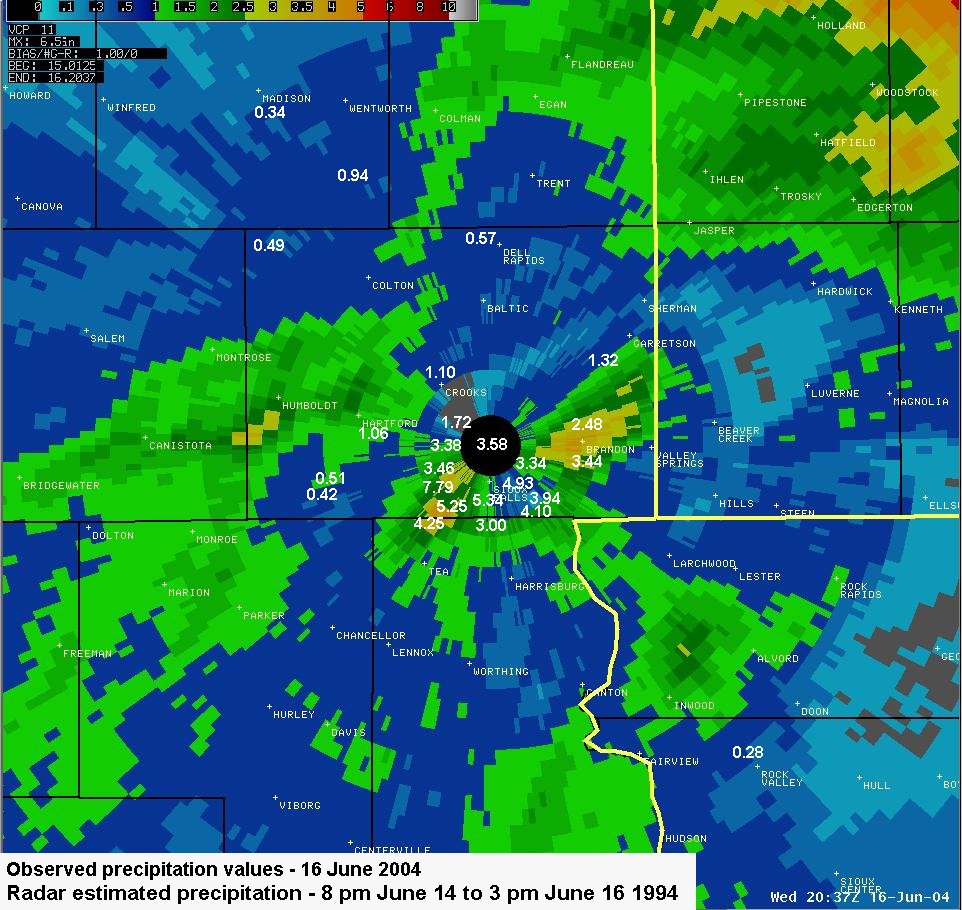
A cold front moved south of Sioux Falls the late in the evening of June 15, and was located between Sioux Falls and Sioux City during the early morning of June 16. Strong thunderstorms developed along the front between 3 am and 4 am June 16 on the west side of Sioux Falls and moved east. As the storms moved to the east, new storm development was observed just west of Sioux Falls, resulting in repeated episodes of heavy rain between 4 am and 7 am in the Sioux Falls metropolitan area. While rainfall amounts were similar to May 29, the rate of rainfall was much higher than observed 3 weeks earlier. At the Sioux Falls airport, over 2 inches of rain was observed in one hour, with multiple locations around the city receiving in excess of 3 inches of rain in 2 hours. The highest rainfall amount reported in Sioux Falls was 7.79 inches, with numerous reports of 3 to 6 inches across the city. See the map below with storm total rainfall for the Sioux Falls metropolitan area (click map to enlarge).
The large amount of rainfall in a short period of time produced excessive runoff across the city. The amount of runoff is illustrated by the rapid rise in both Skunk Creek near Marion Road in Sioux Falls, and the Big Sioux River near North Cliff Avenue. The rise at both locations was solely the result of urban runoff, and indicates how much water inundated the city that morning. The heavy rain ended by 8 am across the city with street flooding subsiding by early afternoon.
Links for 16 June 2004 event:


 Weather Story
 Weather Map
 Local Radar