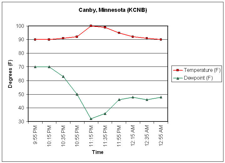
Late last night and early this morning, many locations saw temperatures rise several degrees over a short period of time as thunderstorms moved across the region. This phenomenon is known as a heat burst. Evaporating rainfall from high-based showers and thunderstorms in an extremely hot and dry atmosphere is the cause of this phenomenon. As the rain falls into the very warm and dry air below the base of the thunderstorm, it evaporates before reaching the surface. Initially, this evaporation causes the air to cool below the thunderstorm and the air begins to accelerate toward the surface. Once the air loses its source of cooling, i.e. evaporation from rainfall, it once again begins to warm as approaches the surface of the earth due to compression. As the air nears the earths surface, it will become warmer than the air around it. Once it reaches the ground it will result in local wind gusts at the same time the temperature rises and dew points fall. In Canby, Minnesota, the temperature rose to 100 degrees as winds gusted over 60 mph. At the same time, the dew point fell into the 30s.
Here is a list of some warm temperatures reached overnight.
CANBY MINNESOTA 100 DEGREES 1115 PM CDT
BENSON MINNESOTA 97 DEGREES 135 AM CDT
WILLMAR MINNESOTA 97 DEGREES 235 AM CDT
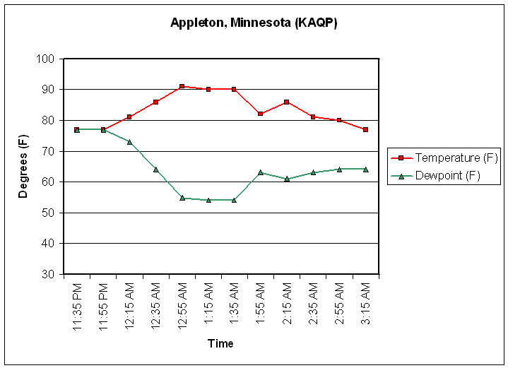
APPLETON MINNESOTA 91 DEGREES 1255 AM CDT
PIPESTONE MINNESOTA 90 DEGREES 235 AM CDT
WORTHINGTON MINNESOTA 90 DEGREES 455 AM CDT
Below are a series of graphs and radar images from across the region showing how temperatures rose with the heat bursts.
Graph of temperature and dew point for Canby, Minnesota.
Graph of temperature and dew point for Appleton, Minnesota.
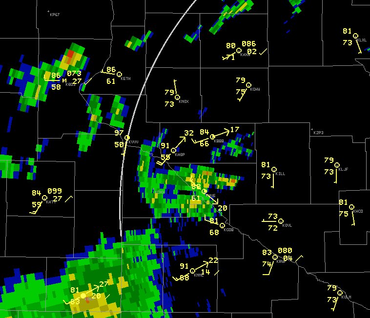
Radar picture and observations around 1:00 AM July 17 in vicinity of Appleton, MN (KAGP). Note that Montevideo, MN (KMVE) was 88 degrees and Ortonville, MN (KVVV) was 97 degrees likely due to a heat burst. Winds were also gusting over 20 kts (23 mph) in many of these locations. Dew points had fallen as low as 50 degrees.
Graph of temperature and dew point for Benson, Minnesota (KBBB) from the early morning of July 17.

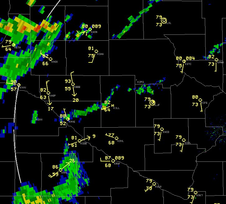
Radar image from Minneapolis, MN and observations around 2:00 AM July 17. At this time, Benson (KBBB) had a temperature of 93 degrees with a dew point of 55.
Graph of temperature and dew point from Clara City, MN (20 miles eat of Montevideo, MN). These observations are taken from a highway sensor. The heat burst occured around 1:00 am.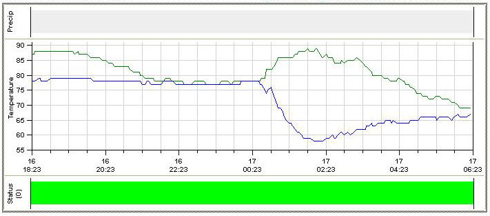
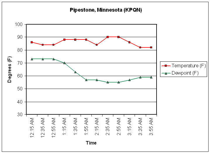
Graph of temperature and dew point from Pipestone, MN.
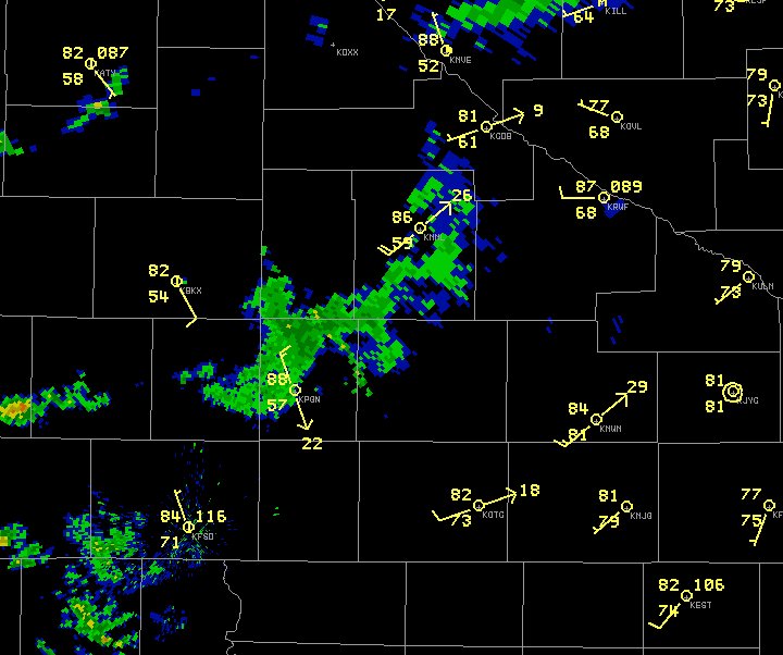
Radar picture around 2 AM July 17 from the radar in Sioux Falls, SD. As the first showers approach Pipestone, the outflow moves through Pipestone, the temperature rose to 88 degrees and the dew point fell into the middle 50s.
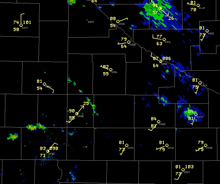
Radar from Sioux Falls, SD and observations from around 3:00 AM July 17. Notice the lower dew points around Pipestone (KPQN), Brookings, SD (KBKX), and Marshall, MN (KMML). The showers that produced this heat burst have almost completely dissipate around Pipestone. Notice that with the showers south of Pipestone, the wind has switched to southwest and continues to gust over 20 mph.
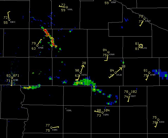
A graph of temperature and dew point from Worthington, Minnesota.
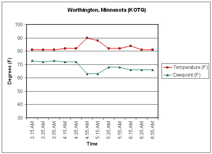
Radar picture from 5:00 AM July 17 with observations. This heat burst was associated with a second area of showers and thunderstorms developed near Sioux Falls and moved along and south of interstate 90. As the outflow reached Worthington, winds gusted to 33 mph and the temperature rose to 90 degrees. Notice that although the temperatures have cooled around Pipestone the dew points remain in the lower 60s.


 Weather Story
 Weather Map
 Local Radar