A series of storms during late February and early March, including a widespread blizzard which closed many roads across the area, produced one to two feet of new snowfall across eastern South Dakota, into the adjacent areas of Minnesota, Iowa and Nebraska. Below is a map showing the snowfall totals for the week from February 24 to March 2, 2007, followed by a text listing of the plotted snowfall values.
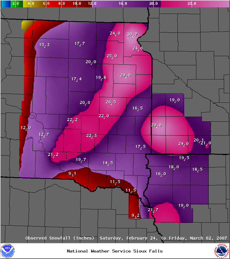
Weekly total snowfall for various sites in South Dakota, southwest Minnesota,
northwest Iowa, and far northeast Nebraska from Saturday, February 24th to
Friday, March 2nd, 2007...

inches   location

30.7     Sisseton, SD
29.0     Watertown, SD
29.0     Pipestone, MN
26.5     De Smet, SD
25.0     Webster, SD
24.6     Wilmot, SD
24.0     Worthington, MN
24.0     Britton, SD
22.3     Mitchell, SD
22.2     Wessington Springs, SD
22.0     Carthage, SD
21.8     Sioux City, IA
21.2     Academy, SD
21.0     Jackson, MN
20.1     Lakefield, MN
20.0     Huron, SD
19.8     Clark, SD
19.7     Armour, SD
19.5     Ocheyedan, IA
19.0     Marshall, MN
19.0     Holstein, IA
18.5     Spencer, IA
18.0     Sheldon, IA
17.7     Aberdeen, SD
17.5     Sioux Falls, SD
17.4     Redfield, SD
16.5     Brookings, SD
16.0     Sioux Center, IA
15.3     Roscoe, SD
14.5     Menno, SD
12.7     Chamberlain, SD
12.0     Kennebec, SD
11.5     Yankton, SD
11.5     Vermillion, SD
9.2      Wakefield, NE
9.1      Pickstown, SD


 Weather Story
 Weather Map
 Local Radar