On the evening of May 1, 2008, a line of supercell thunderstorms developed across southeast South Dakota and northwest Iowa. These storms produced five tornadoes across northwest Iowa (see detailed track map), as well as hail up to softball size in southeast South Dakota. Below is a map showing where the severe weather occurred as well as a brief description of what occurred.
.png)
Tornado Reports
| Time (UTC) | Location | County | State | Lat | Lon | Comments |
| 2359 | SIOUX CENTER | SIOUX | IA | 43.08 | -96.17 | JUST NORTH OF SIOUX CENTER (FSD) |
| 0007 | ROCK VALLEY | SIOUX | IA | 43.2 | -96.3 | (FSD) |
| 0008 | 2 SE INWOOD | LYON | IA | 43.27 | -96.41 | (FSD) |
| 0025 | INWOOD | LYON | IA | 43.29 | -96.44 | (FSD) |
| 0030 | 1 E DOON | LYON | IA | 43.28 | -96.21 | (FSD) |
| 0044 | 2 W GEORGE | LYON | IA | 43.34 | -96.04 | TORNADO MOVING NORTH. (FSD) |
Hail Reports
| Time (UTC) | Size (inches) | Location | County | State | Lat | Lon | Comments |
| 2149 | 1.00 | 4 NE TYNDALL | BON HOMME | SD | 43.03 | -97.81 | (FSD) |
| 2217 | 0.75 | 7 W YANKTON | YANKTON | SD | 42.89 | -97.53 | (FSD) |
| 2222 | 0.75 | 1 WSW SIOUX FALLS | MINNEHAHA | SD | 43.54 | -96.75 | FROM CENTER OF SIOUX FALLS (FSD) |
| 2223 | 0.88 | 4 W LESTERVILLE | BON HOMME | SD | 43.04 | -97.67 | FEW NICKEL. (FSD) |
| 2237 | 0.88 | 5 NE UTICA | YANKTON | SD | 43.03 | -97.43 | (FSD) |
| 2256 | 0.75 | 7 ENE ARMOUR | DOUGLAS | SD | 43.36 | -98.22 | (FSD) |
| 2308 | 1.75 | 5 NW IRENE | YANKTON | SD | 43.13 | -97.23 | (FSD) |
| 2310 | 1.00 | MENNO | HUTCHINSON | SD | 43.24 | -97.58 | (FSD) |
| 2321 | 1.00 | 9 S MOUNT VERNON | DAVISON | SD | 43.58 | -98.26 | (FSD) |
| 2328 | 1.00 | DIMOCK | HUTCHINSON | SD | 43.48 | -97.99 | (FSD) |
| 2339 | 4.25 | 12 S MARION | TURNER | SD | 43.25 | -97.26 | AT TURKEY RIDGE (FSD) |
| 2345 | 1.00 | 3 ESE SIOUX FALLS | MINNEHAHA | SD | 43.53 | -96.68 | 3 ESE FROM CENTER OF SIOUX FALLS (FSD) |
| 0016 | 0.88 | 2 SW WALL LAKE | MINNEHAHA | SD | 43.51 | -96.99 | (FSD) |
| 0017 | 1.50 | 4 S SIOUX FALLS | LINCOLN | SD | 43.48 | -96.74 | (FSD) |
| 0022 | 0.75 | 1 WSW SIOUX FALLS | MINNEHAHA | SD | 43.54 | -96.75 | FROM CENTER OF SIOUX FALLS (FSD) |
| 0105 | 1.00 | 4 SSW WENTWORTH | LAKE | SD | 43.94 | -96.99 | (FSD) |
| 0118 | 0.75 | ARCO | LINCOLN | MN | 44.38 | -96.18 | (FSD) |
| 0125 | 0.88 | 8 SSE HURON | BEADLE | SD | 44.26 | -98.16 | (FSD) |
| 0150 | 0.75 | WOLSEY | BEADLE | SD | 44.41 | -98.47 | (FSD) |
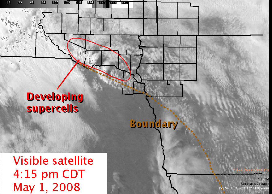
Thunderstorms began to develop along a boundary that separated relatively dry air from moist air. This boundary lifted north out of northeast Nebraska into southeast South Dakota and northwest Iowa into a relatively unstable atmosphere. Initially, storms developed along the Missouri River Valley in far northeast Nebraska moving north around 30 mph. These storms formed in a location that was covered in clouds much of the day, and as a result was slightly more stable than the storms that developed in northwest Iowa. As a result, the primary threat with these storms was large hail as the rotation in the storms was confined to the middle portions of the storm.
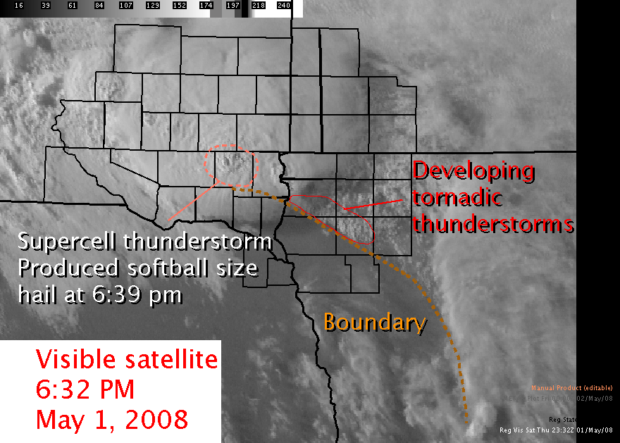
Thunderstorms that developed near the Missouri River Valley continued to work north producing softball sized hail near Turkey Ridge. At the same time, thunderstorms rapidly developed along the boundary across northwest Iowa. The atmosphere over northwest Iowa had become extremely unstable due to the partial sunshine in the afternoon hours. Winds in the atmosphere rapidly changed direction and speed with height, and as these storms developed they immediately began rotating, producing tornadoes shortly after their initiation.
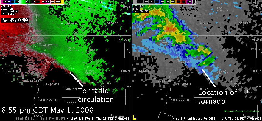
The first tornado developed shortly before 7 PM near Sioux Center, Iowa. The tornado moved north-northwest as the circulation wrapped back into the storm. The velocity image above on the left shows the winds blowing towards (shown in green) and away (shown in red) from the radar. The tight circulation is noted where the green colors are immediately adjacent to the red colors. The corresponding radar image is shown to the right.
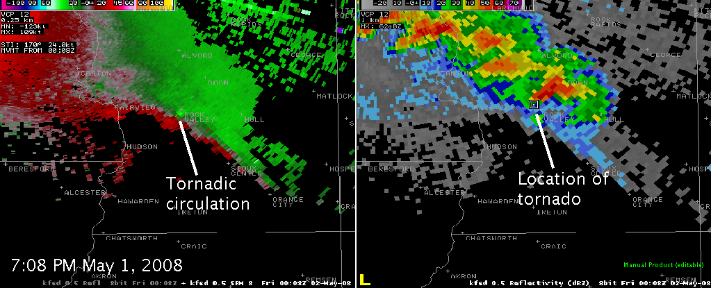
Additional tornadoes rapidly developed across northwest Iowa. The tornado near Rock Valley, IA developed a rather large debris circulation. Trained spotters reported a debris cloud that at times reached a quarter mile wide.
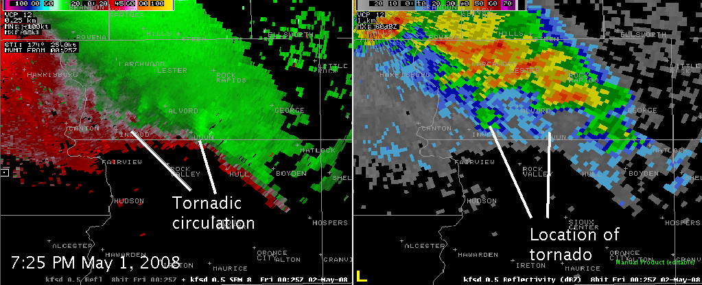
Several tornadic circulations continued to develop along the boundary across northwest Iowa. Two additional tornadic circulations are noted in the above image near Inwood and Doon, Iowa.


 Weather Story
 Weather Map
 Local Radar