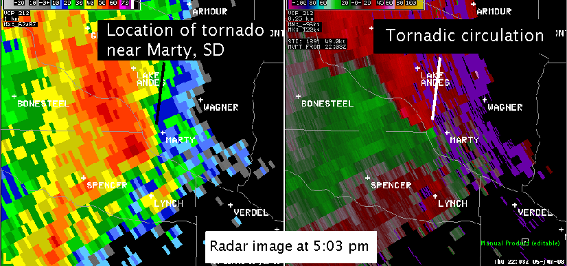
Around 5:02 pm CDT, a tornado was reported near Marty, SD and moved north to near Ravinia, SD. The tornado was on the ground for approximately 10 minutes. One home and one farmstead was damaged. In addition, other farms reported outbuidlings damaged or destroyed as well as trees and power lines down.
The structure of this tornadic thunderstorm was different than is typically seen. Instead of an isolated thunderstorm, called a supercell, this tornado developed on the leading edge of squall line. These tornadoes develop quickly and also dissipate quickly. While these tornadoes can be very strong, there life span tends to be shorter than with supercell tornadoes. Also, they develop on the leading edge of the squall line as can be seen in the image below. Although not shown, the circulation seen below was only observed on radar for approximately 10 minutes.
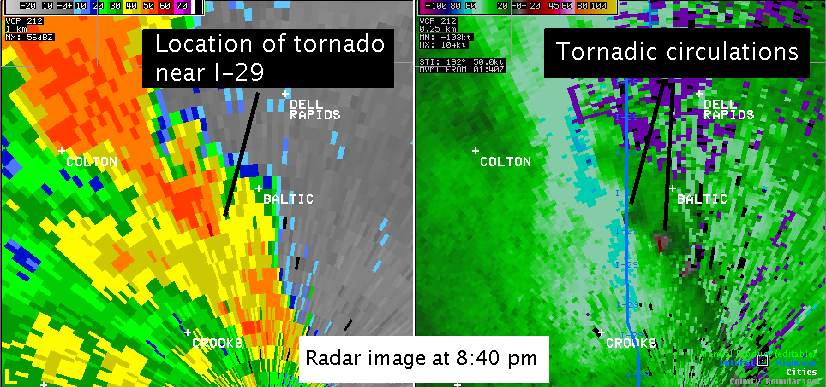
The squall line continued to move east through the evening, approaching Turner and Minnehaha County around 8 pm CDT. At the same time, a strong warm front moved north from Iowa and Nebraska. This warm front moved north of Sioux Falls around 8 pm CDT with the temperature rising to 75 degrees and the wind shifting to southeast. As the squall line intersected the front , several small circulations developed along the front. Like the tornado in Marty, these circulations developed quickly and near the surface. They also developed near where the front intersected the squall line. The first tornado was reported south of Humboldt around 8:15 pm CDT. Several other circulation developed over the next 45 minutes as the storm move east across Minnehaha County. A strong circulation was seen on radar, and tornado was reported, southwest of Baltic around 8:44 pm CDT. Debris was seen moving across Interstate 29 and trees and power lines were down. Based upon a late evening onsite survey done by the National Weather Service and Minnehaha County Emergency Management, this tornado has been rated EF2 with winds estimated around 115 mph.
Below is the lowest elevation velocity and reflectivity image at 8:40 pm CDT. Notice there are two circulation seen at this time - the tornadic circulation near Interstate 29 and a second circulation south of Baltic. This second circulation may have been responsible for a second tornado reported south of Baltic around the same time. As with the circulation near Marty, these circulation dissipated quickly as they moved east of Dell Rapids.
With the warm front nearly stationary, this squall line rapidly moved north of the front into cooler and more stable air. By the time the squall line reached northern Moody County, the circulations and threat of tornadoes had diminished.
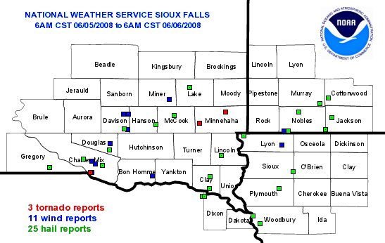
Tornado Reports
| Time (UTC) | Location | County | State | Lat | Lon | Comments |
| 2210 | 1 W MARTY | CHARLES MIX | SD | 42.99 | -98.45 | TORNADO DAMAGE FROM AROUND 1 MILE WEST OF MARTY TO 1 MILE EAST OF RAVINIA. DAMAGE OCCURRED FROM APPROXIMATELY 500 PM TO 520 PM CDT. ONE FARMSTEAD DESTROYED... OUTBUILDI (FSD) |
| 0115 | 2 S HUMBOLDT | MINNEHAHA | SD | 43.62 | -97.07 | TRAIN SPOTTERS REPORTED A TORNADO ON THE GROUND 2 MILES SOUTH OF HUMBOLDT (FSD) |
| 0142 | S BALTIC | MINNEHAHA | SD | 43.76 | -96.74 | TORNADO ON THE GROUND 1/2 MILES SOUTH OF BALTIC (FSD) |
Hail Reports
| Time (UTC) | Size (inches) | Location | County | State | Lat | Lon | Comments |
| 1605 | 1.00 | LAKE ANDES | CHARLES MIX | SD | 43.16 | -98.54 | (FSD) |
| 1611 | 1.75 | WAGNER | CHARLES MIX | SD | 43.08 | -98.3 | (FSD) |
| 1630 | 1.00 | 3 WNW DELMONT | DOUGLAS | SD | 43.28 | -98.21 | (FSD) |
| 1705 | 0.75 | SW EMERY | HANSON | SD | 43.6 | -97.62 | (FSD) |
| 1723 | 1.00 | 2 NNW SALIX | WOODBURY | IA | 42.34 | -96.3 | (FSD) |
| 1740 | 0.88 | 4 S SIOUX CITY | WOODBURY | IA | 42.44 | -96.39 | (FSD) |
| 1741 | 1.00 | SALEM | MCCOOK | SD | 43.72 | -97.39 | (FSD) |
| 1742 | 1.75 | 1 NW VERMILLION | CLAY | SD | 42.79 | -96.94 | GOLF BALL TO SLIGHTLY LARGER HAIL (FSD) |
| 1745 | 0.75 | 3 W LARCHWOOD | LYON | IA | 43.46 | -96.5 | (FSD) |
| 1745 | 2.50 | 4 E ELLSWORTH | NOBLES | MN | 43.52 | -95.94 | (FSD) |
| 1750 | 1.25 | 2 W MASKELL | CEDAR | NE | 42.69 | -97.03 | (FSD) |
| 1750 | 1.25 | 1 W MASKELL | DIXON | NE | 42.69 | -97 | (FSD) |
| 1753 | 0.75 | 2 S OYENS | PLYMOUTH | IA | 42.79 | -96.06 | (FSD) |
| 1812 | 0.75 | 11 N VERMILLION | CLAY | SD | 42.94 | -96.93 | (FSD) |
| 1815 | 0.75 | 1 NNW GRANVILLE | SIOUX | IA | 43 | -95.88 | (FSD) |
| 1818 | 1.75 | 4 E ELLSWORTH | NOBLES | MN | 43.52 | -95.94 | (FSD) |
| 1838 | 0.75 | 9 N BERESFORD | LINCOLN | SD | 43.21 | -96.79 | (FSD) |
| 1839 | 1.75 | 1 E WILMONT | NOBLES | MN | 43.76 | -95.81 | (FSD) |
| 1850 | 1.00 | ROUND LAKE | NOBLES | MN | 43.54 | -95.47 | (FSD) |
| 1850 | 0.75 | 3 E FULDA | MURRAY | MN | 43.87 | -95.54 | (FSD) |
| 1902 | 0.88 | 5 SW OKABENA | JACKSON | MN | 43.69 | -95.39 | (FSD) |
| 1908 | 0.75 | 7 S WESTBROOK | COTTONWOOD | MN | 43.94 | -95.43 | (FSD) |
| 2133 | 0.75 | 2 SW BONESTEEL | GREGORY | SD | 43.06 | -98.97 | (FSD) |
| 2312 | 0.75 | 2 W ETHAN | DAVISON | SD | 43.55 | -98.02 | WIND GUSTS TO 40 MPH (FSD) |
| 0045 | 0.88 | 6 NW MADISON | LAKE | SD | 44.07 | -97.19 | (FSD) |


 Weather Story
 Weather Map
 Local Radar