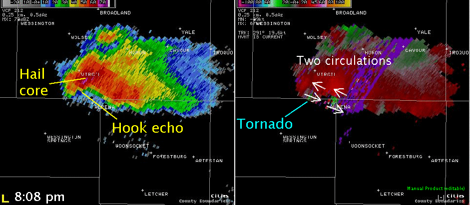
Several tornadoes hit portions of southeast South Dakota on the evening of June 24. These tornadoes were associated with two supercells that developed. A supercell is a thunderstorm which has a rotating updraft and is responsible for a majority of tornadoes that affect the United States. The first supercell developed shortly after 7 pm CDT southwest of Huron, South Dakota. This storm moved east-southeast toward Virgil. Around 8:07 pm CDT, the first tornado was reported 1 mile south of Virgil. On the image below, a hook echo can be seen on the reflectivity on the left. It is within this hook echo that the tornadic circulation will form. The right image shows the storm relative velocity and two circulations are seen - one south of Virgil and the second near Alpena. It is believed that the western circulation near Virgil was the one that produced the tornado. Finally, at the same time the tornado occurred, destructive hail was occuring south of Virgil. Up to golf ball size hail was reported which resulted in over 6 square miles of crop damage south of Virgil.
Below is a picture of the storm taken at 8:06 pm CDT.
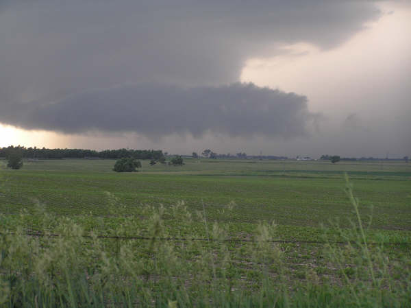
Photo taken by Nick Hartley, Brookings Register
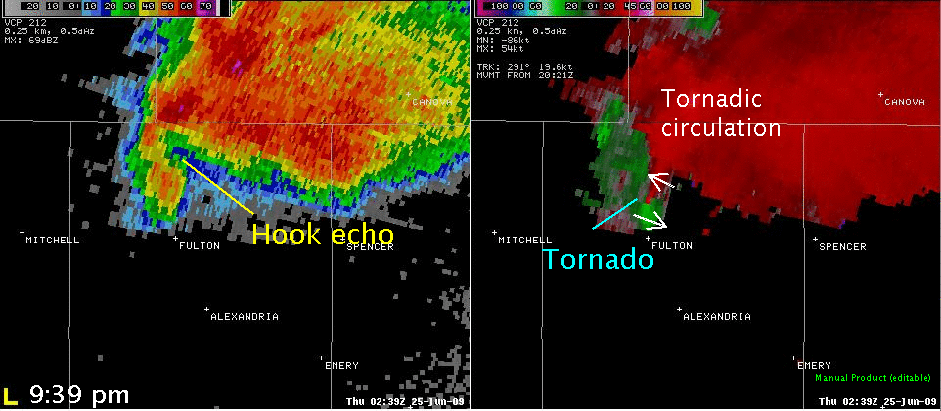
The storm continued to move southeast. By 9:40 pm, the supercell was located north of Fulton, South Dakota. This is where the storm produce two tornadoes near Fulton. On the radar picture below, a hook echo is apparent north of Fulton (left). A very strong circulation can be seen on the storm relative velocity image (right).
Picture of the tornado north of Fulton at 9:43 pm CDT.
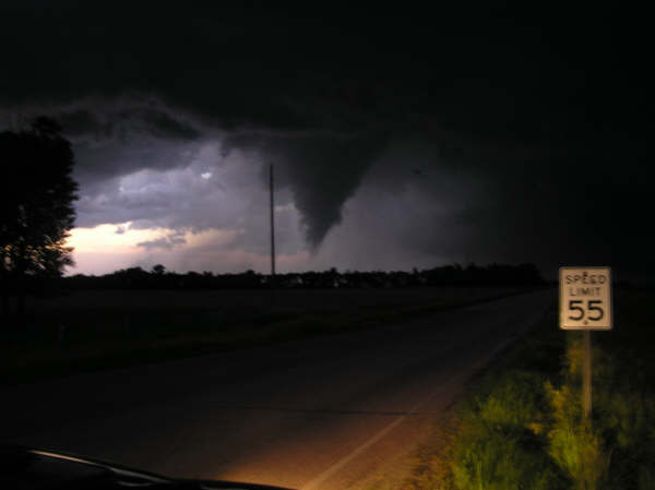
Photo courtesy of Nick Hartley, Brookings Register
Finally, around 11 pm CDT, a second supercell began to develop between Mitchell and Chamberlain in Aurora County, South Dakota. This was a classic splitting supercell. A splitting supercell is one in which there is a left-moving supercell with an anticyclonic rotation and a right-moving supercell with a cyclonic circulation. Typically the anticyclonic supercell will produce large hail but rarely produce a tornado while the cyclonic supercell can produce tornadoes in addition to large hail. The right-moving supercell did produce a weak tornado 15 miles east of Platte in Douglas County around 12:25 am CDT as well as golf ball size hail west of Stickney. The left-moving supercell produced 1 inch hail northeast of Plankinton.
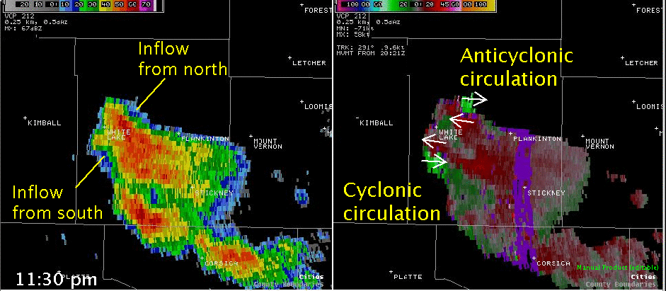
At 11:30 pm CDT, the supercell was just beginning to split. On the reflectivity image, it still appears as a single storm. However, one can see an indentation on the southwest and northwest side of the storm indicative of inflow and two updrafts. When looking at the storm relative velocity image, two circulations are evident. On the southwest side storm, collocated with the inflow, there is a strong cyclonic circulation. On the north side of the storm a strong anticyclonic circulation can be see where the inflow was forming with the left-moving supercell.
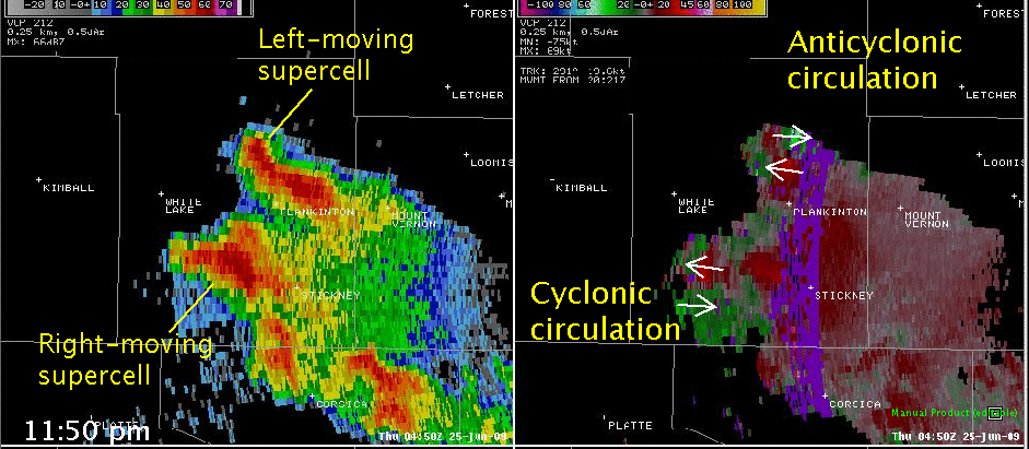
At 11:50 pm CDT, the supercell has split into two storms. The left-moving supercell has begun to move to the east-northeast north of Plankinton and the right-moving supercell has begun to move south-southeast west of Stickney. The left-moving supercell maintains a strong anticyclonic circulation on the north side of the storm. Also, the inflow of warm and moist air is on the north side of the storm which results in a storm shape that is the "reverse" of what we typically see with a supercell thunderstorm with a broad "hook" on the north side. The right-moving supercell has a strong and broad cyclonic circulation. There is a broad hook on the southwest side of the storm and large hail, up to golf ball size, was falling east of the hook.
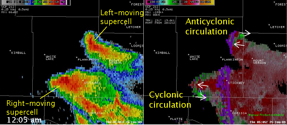
The final radar image, from 12:05 am CDT, shows that the supercells have completely split. The left-moving supercell continues to show a strong anticyclonic circulation along the Davison and Aurora County border north of Mount Vernon. The broad hook echo remains apparent where the circulation is located. The much larger right-moving supercell has moved south and is approaching the Douglas County line. A strong cyclonic circulation continues to be evident on the southwest side of the storm. After this time, the left-moving supercell weakened after moving into Davison County while the right moving supercell continue to produce large hail and a few damaging wind gusts as it moved across Douglas County and into Bon Homme County after 1:00 am CDT.
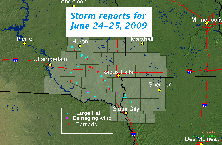
A summary of reports from June 24-25, 2009.
PRELIMINARY LOCAL STORM REPORT...SUMMARY
NATIONAL WEATHER SERVICE SIOUX FALLS SD
1033 PM CDT THU JUN 25 2009
..TIME... ...EVENT... ...CITY LOCATION... ...LAT.LON...
..DATE... ....MAG.... ..COUNTY LOCATION..ST.. ...SOURCE....
..REMARKS..
0745 PM HAIL 2 WNW VIRGIL 44.30N 98.46W
06/24/2009 E0.75 INCH BEADLE SD TRAINED SPOTTER
0750 PM HAIL 6 S HURON 44.28N 98.21W
06/24/2009 E0.75 INCH BEADLE SD EMERGENCY MNGR
0757 PM HAIL 2 WNW VIRGIL 44.30N 98.46W
06/24/2009 E1.00 INCH BEADLE SD TRAINED SPOTTER
0759 PM HAIL 2 NW VIRGIL 44.31N 98.46W
06/24/2009 E1.00 INCH BEADLE SD PUBLIC
0802 PM HAIL 1 WSW VIRGIL 44.29N 98.45W
06/24/2009 E1.75 INCH BEADLE SD EMERGENCY MNGR
0807 PM TORNADO 1 S VIRGIL 44.28N 98.43W
06/24/2009 BEADLE SD PUBLIC
WEAK MULTIPLE VORTEX TORNADO.
0815 PM HAIL 4 N ALPENA 44.24N 98.37W
06/24/2009 E1.75 INCH BEADLE SD PUBLIC
6 SQUARE MILES OF CROPS WAS DESTROYED BY LARGE HAIL.
0850 PM HAIL 7 N FORESTBURG 44.13N 98.11W
06/24/2009 E1.75 INCH SANBORN SD PUBLIC
GROUND WHITE FROM LARGE HAIL
0850 PM HAIL 8 NNE FORESTBURG 44.13N 98.05W
06/24/2009 E1.00 INCH SANBORN SD TRAINED SPOTTER
0900 PM TORNADO 3 S ARTESIAN 43.97N 97.92W
06/24/2009 SANBORN SD PUBLIC
RAIN WRAPPED TORNADO.
0910 PM HAIL ARTESIAN 44.01N 97.92W
06/24/2009 E2.00 INCH SANBORN SD TRAINED SPOTTER
DAMAGED NUMEROUS CAR WINDOWS, STRONG WINDS BROKE SMALL
BRANCHES
0915 PM HAIL 4 ESE FORESTBURG 44.00N 98.03W
06/24/2009 E1.75 INCH SANBORN SD LAW ENFORCEMENT
0941 PM TORNADO 3 N FULTON 43.77N 97.82W
06/24/2009 HANSON SD STORM CHASER
TWO TORNADOES
0942 PM TORNADO 3 E FULTON 43.73N 97.76W
06/24/2009 HANSON SD EMERGENCY MNGR
1015 PM TSTM WND GST 3 NE EMERY 43.63N 97.58W
06/24/2009 E60.00 MPH MCCOOK SD PUBLIC
NUMEROUS BRANCHES DOWN, LASTED 15 MINUTES
1026 PM TORNADO 1 N BRIDGEWATER 43.56N 97.50W
06/24/2009 MCCOOK SD STORM CHASER
1033 PM HAIL 1 N DOLTON 43.51N 97.38W
06/24/2009 E2.00 INCH MCCOOK SD TRAINED SPOTTER
1104 PM HAIL 2 W PARKER 43.40N 97.18W
06/24/2009 E1.00 INCH TURNER SD EMERGENCY MNGR
1104 PM TORNADO 3 S MARION 43.38N 97.26W
06/24/2009 TURNER SD EMERGENCY MNGR
1118 PM HAIL HURLEY 43.28N 97.09W
06/24/2009 E1.75 INCH TURNER SD BROADCAST MEDIA
1139 PM TORNADO VIBORG 43.17N 97.08W
06/24/2009 TURNER SD BROADCAST MEDIA
1149 PM HAIL 8 SW PLANKINTON 43.64N 98.60W
06/24/2009 E1.75 INCH AURORA SD FIRE DEPT/RESCUE
1154 PM HAIL 6 WNW STICKNEY 43.61N 98.55W
06/24/2009 E1.75 INCH AURORA SD LAW ENFORCEMENT
1204 AM HAIL 2 NE CENTERVILLE 43.14N 96.93W
06/25/2009 E1.00 INCH TURNER SD TRAINED SPOTTER
1205 AM HAIL 7 NE PLANKINTON 43.79N 98.38W
06/25/2009 E1.00 INCH AURORA SD PUBLIC
1215 AM HAIL 7 NNW MOUNT VERNON 43.81N 98.31W
06/25/2009 E0.88 INCH DAVISON SD TRAINED SPOTTER
1218 AM TSTM WND GST BERESFORD 43.08N 96.78W
06/25/2009 E60.00 MPH UNION SD FIRE DEPT/RESCUE
1227 AM TORNADO 15 E PLATTE 43.39N 98.55W
06/25/2009 DOUGLAS SD LAW ENFORCEMENT
1230 AM HEAVY RAIN 4 ESE DELMONT 43.24N 98.09W
06/25/2009 E2.00 INCH HUTCHINSON SD TRAINED SPOTTER
OCCURRED IN 15-20 MINUTES, BUT NO FLOODING CAUSED
1232 AM FUNNEL CLOUD 2 W CORSICA 43.42N 98.45W
06/25/2009 DOUGLAS SD LAW ENFORCEMENT
1245 AM FUNNEL CLOUD 8 SW CORSICA 43.34N 98.52W
06/25/2009 DOUGLAS SD LAW ENFORCEMENT
1250 AM HAIL 5 NW DELMONT 43.32N 98.23W
06/25/2009 E1.00 INCH DOUGLAS SD TRAINED SPOTTER
1257 AM HAIL HAWARDEN 43.00N 96.48W
06/25/2009 E0.88 INCH SIOUX IA TRAINED SPOTTER
1259 AM HAIL 2 N CHATSWORTH 42.95N 96.51W
06/25/2009 E1.00 INCH SIOUX IA EMERGENCY MNGR
0100 AM HAIL ARMOUR 43.32N 98.34W
06/25/2009 E0.88 INCH DOUGLAS SD LAW ENFORCEMENT
0100 AM HAIL 3 W ARMOUR 43.32N 98.40W
06/25/2009 E1.00 INCH DOUGLAS SD LAW ENFORCEMENT
CROP DAMAGE
0100 AM HAIL 6 S HAWARDEN 42.92N 96.48W
06/25/2009 E1.00 INCH SIOUX IA EMERGENCY MNGR
CROP DAMAGE
0105 AM TSTM WND DMG 9 N AVON 43.14N 98.06W
06/25/2009 BON HOMME SD PUBLIC
LARGE TREE BRANCHES BROKEN OFF LARGE COTTONWOOD,
PEA-SIZED HAIL
0110 AM FLASH FLOOD ARMOUR 43.32N 98.34W
06/25/2009 DOUGLAS SD LAW ENFORCEMENT
WATER 4-6 INCHES DEEP OVER ROAD
0115 AM TSTM WND DMG 11 NNE WAGNER 43.23N 98.22W
06/25/2009 CHARLES MIX SD PUBLIC
TREE BRANCHES DOWN
0136 AM HAIL BRUNSVILLE 42.81N 96.27W
06/25/2009 E1.00 INCH PLYMOUTH IA TRAINED SPOTTER
0145 AM FLASH FLOOD 9 N AVON 43.14N 98.06W
06/25/2009 BON HOMME SD PUBLIC
CREEK RUNNING OUT OF ITS BANKS, CULVERTS WASHED OUT,
RECEIVED 2.5 INCHES OF RAIN IN 1 HOUR
0145 AM HAIL 7 NE AVON 43.09N 97.97W
06/25/2009 E1.00 INCH BON HOMME SD TRAINED SPOTTER
CROPS WERE DAMAGED BY COMBINATION OF LARGE HAIL AND WIND
0145 AM TSTM WND GST 7 NE AVON 43.09N 97.97W
06/25/2009 E60.00 MPH BON HOMME SD TRAINED SPOTTER
SEVERAL BRANCHES KNOCKED DOWN BY THUNDERSTORM WIND GUSTS.
0224 AM HAIL 5 SSE TABOR 42.88N 97.62W
06/25/2009 E1.00 INCH YANKTON SD TRAINED SPOTTER


 Weather Story
 Weather Map
 Local Radar