Overview
|
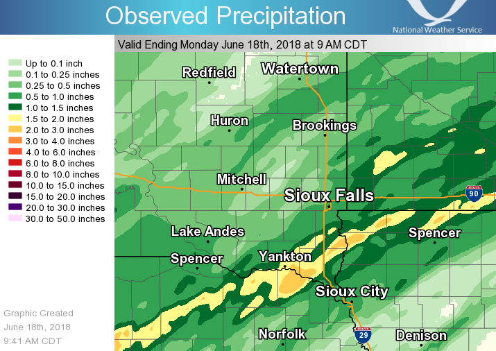
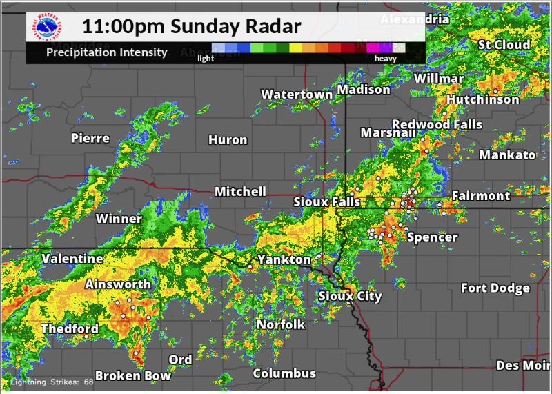
A slow-moving cold front and a weak surface low associated with the remnants of the Tropical Depression Bud, brought areas of heavy rain across the region during the night of June 17-18. A swath of 1 to almost 4 inches of rain fell from northeastern Nebraska to southwestern Minnesota. |
Lightning Data from: National Lightning Detection Network (NLDN) |
 |
 |
 |
|
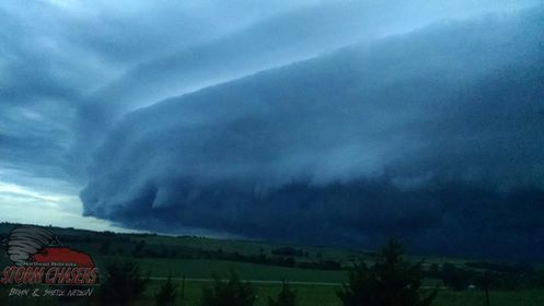
Strong Storms moving over Ponca, Nebraska. Photo taken 3 miles west of Ponca, NE. Credit: Brian Nelson |
Street Flooding in Vermillion area Credit: Derek Thompson |
24- Hour Observed Precipitation
|
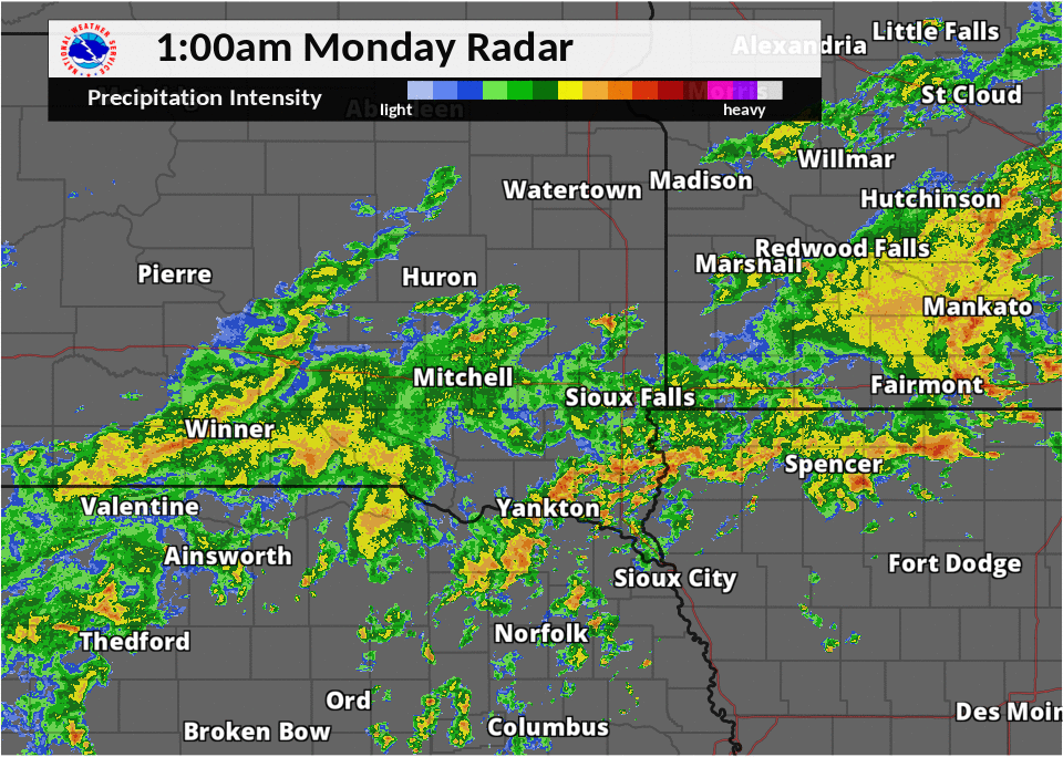
Radar:
Header
 |
 |
 |
|
Radar Loop Sunday Evening (7pm Sunday - 1am Monday) |
Radar Loop Sunday Night (1am - 7am Monday)
|
8:00 pm Radar: Storms near the Missouri River and in the Yankton area producing almost 5,000 lightning indications over a 5 minute timespan. Lightning Credit:Earth Networks Total Lightning Network |
Storm Reports
PRELIMINARY LOCAL STORM REPORT...SUMMARY
NATIONAL WEATHER SERVICE SIOUX FALLS SD
246 PM CDT MON JUN 18 2018
..TIME... ...EVENT... ...CITY LOCATION... ...LAT.LON...
..DATE... ....MAG.... ..COUNTY LOCATION..ST.. ...SOURCE....
..REMARKS..
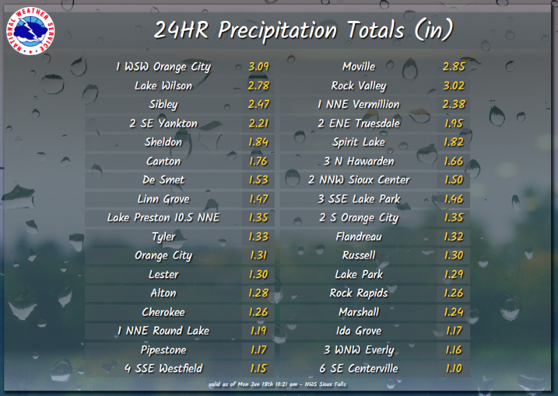
0541 AM HEAVY RAIN 3 W DICKENS 43.13N 95.09W
06/18/2018 M3.88 INCH CLAY IA MESONET
MESONET STATION RSPI4, 3 W DICKENS.
0603 AM HEAVY RAIN GEORGE 43.34N 96.00W
06/18/2018 M3.60 INCH LYON IA PUBLIC
VIA SOCIAL MEDIA. RAINFALL FROM 10 PM SUNDAY
THROUGH 6 AM MONDAY.
0838 AM HEAVY RAIN 3 SW MECKLING 42.81N 97.11W
06/18/2018 M3.40 INCH CLAY SD PUBLIC
REPORT VIA SOCIAL MEDIA.
0840 AM HEAVY RAIN YANKTON 42.89N 97.39W
06/18/2018 E3.40 INCH YANKTON SD PUBLIC
REPORT VIA SOCIAL MEDIA.
0630 AM HEAVY RAIN YANKTON 42.88N 97.40W
06/18/2018 M3.30 INCH YANKTON SD PUBLIC
VIA SOCIAL MEDIA.
0540 AM HEAVY RAIN 1 WSW ORANGE CITY 43.00N 96.08W
06/18/2018 M3.04 INCH SIOUX IA MESONET
MESONET STATION RTNI4, 1 WSW ORANGE CITY.
0830 AM HEAVY RAIN ROCK VALLEY 43.21N 96.30W
06/18/2018 E3.02 INCH SIOUX IA CO-OP OBSERVER
0540 AM HEAVY RAIN MOVILLE 42.48N 96.08W
06/18/2018 M2.64 INCH WOODBURY IA MESONET
MESONET STATION RSCI4, MOVILLE.
0600 AM HEAVY RAIN ROCK VALLEY 43.20N 96.31W
06/18/2018 M2.63 INCH SIOUX IA CO-OP OBSERVER
CO-OP OBSERVER STATION RKVI4, ROCK VALLEY.
0600 AM HEAVY RAIN CANTON 43.30N 96.59W
06/18/2018 M2.50 INCH LINCOLN SD PUBLIC
VIA SOCIAL MEDIA. FROM STORMS LAST NIGHT
THRU THIS 6 AM THIS MORNING.
0726 AM HEAVY RAIN OKOBOJI 43.39N 95.14W
06/18/2018 M2.50 INCH DICKINSON IA PUBLIC
VIA SOCIAL MEDIA.
0830 AM HEAVY RAIN SIBLEY 43.40N 95.75W
06/18/2018 E2.47 INCH OSCEOLA IA CO-OP OBSERVER
0600 AM HEAVY RAIN 2 N VERMILLION 42.81N 96.93W
06/18/2018 M2.38 INCH CLAY SD COCORAHS
0530 AM HEAVY RAIN 2 ESE YANKTON 42.88N 97.36W
06/18/2018 M2.21 INCH YANKTON SD CO-OP OBSERVER
0730 AM HEAVY RAIN 6 ESE VERMILLION 42.75N 96.83W
06/18/2018 M2.20 INCH CLAY SD PUBLIC
VIA SOCIAL MEDIA. FROM BURBANK, SD.
0515 AM HEAVY RAIN 2 N VERMILLION 42.82N 96.92W
06/18/2018 M2.11 INCH CLAY SD MESONET
MESONET STATION VERS2, 2 N VERMILLION.
0700 AM HEAVY RAIN SPIRIT LAKE 43.42N 95.10W
06/18/2018 M2.06 INCH DICKINSON IA PUBLIC
VIA SOCIAL MEDIA. RAINFALL THRU 7 AM.
0540 AM HEAVY RAIN IDA GROVE 42.35N 95.48W
06/18/2018 M2.04 INCH IDA IA MESONET
MESONET STATION RIGI4, IDA GROVE.
0530 AM HEAVY RAIN 3 N HAWARDEN 43.05N 96.49W
06/18/2018 M1.66 INCH UNION SD MESONET
MESONET STATION HWDI4, 3 N HAWARDEN.
0600 AM HEAVY RAIN LINN GROVE 42.90N 95.24W
06/18/2018 M1.45 INCH BUENA VISTA IA MESONET
MESONET STATION LNNI4, LINN GROVE.
0559 AM HEAVY RAIN SIOUX CENTER 43.06N 96.17W
06/18/2018 M1.34 INCH SIOUX IA MESONET
MESONET STATION E2631, SIOUX CENTER.
0603 AM HEAVY RAIN TYLER 44.28N 96.13W
06/18/2018 M1.32 INCH LINCOLN MN MESONET
MESONET STATION AS656, TYLER.
0530 AM HEAVY RAIN RUSSELL 44.32N 95.95W
06/18/2018 M1.28 INCH LYON MN MESONET
MESONET STATION RUSM5, RUSSELL.
0600 AM HEAVY RAIN ALTON 42.98N 96.00W
06/18/2018 M1.27 INCH SIOUX IA MESONET
MESONET STATION ALTI4, ALTON.
0610 AM HEAVY RAIN 3 SSE LAKE PARK 43.40N 95.31W
06/18/2018 M1.19 INCH DICKINSON IA MESONET
MESONET STATION AS497, 3 SSE LAKE PARK.
0550 AM HEAVY RAIN 1 NNE ROUND LAKE 43.56N 95.45W
06/18/2018 M1.19 INCH JACKSON MN MESONET
MESONET STATION E3286, 1 NNE ROUND LAKE.
0545 AM HEAVY RAIN MARSHALL 44.43N 95.83W
06/18/2018 M1.19 INCH LYON MN MESONET
MESONET STATION MSHM5, MARSHALL.
0530 AM HEAVY RAIN PIPESTONE 43.99N 96.43W
06/18/2018 M1.17 INCH PIPESTONE MN CO-OP OBSERVER
CO-OP OBSERVER STATION PSTM5, PIPESTONE.
0603 AM HEAVY RAIN SIOUX CENTER 43.08N 96.16W
06/18/2018 M1.13 INCH SIOUX IA MESONET
MESONET STATION AR437, SIOUX CENTER.
0511 AM HEAVY RAIN 4 SSE WESTFIELD 42.70N 96.58W
06/18/2018 M1.13 INCH PLYMOUTH IA MESONET
MESONET STATION BKTI4, 4 SSE WESTFIELD.
0515 AM HEAVY RAIN SPIRIT LAKE 43.47N 95.12W
06/18/2018 M1.02 INCH DICKINSON IA MESONET
MESONET STATION SLKI4, SPIRIT LAKE.
&&
$$
Rain Reports
 |
Media use of NWS Web News Stories is encouraged! Please acknowledge the NWS as the source of any news information accessed from this site. |
|


 Weather Story
 Weather Map
 Local Radar