Overview
|
A large winter storm brought a wide variety of weather to the region. Precipitation began as a wintry mix of rain, freezing rain, and occasional sleet Friday night before a transition to snow Saturday. Gusty northerly winds also led to areas of blowing snow. The same storm system brought severe weather to other portions of the country. |
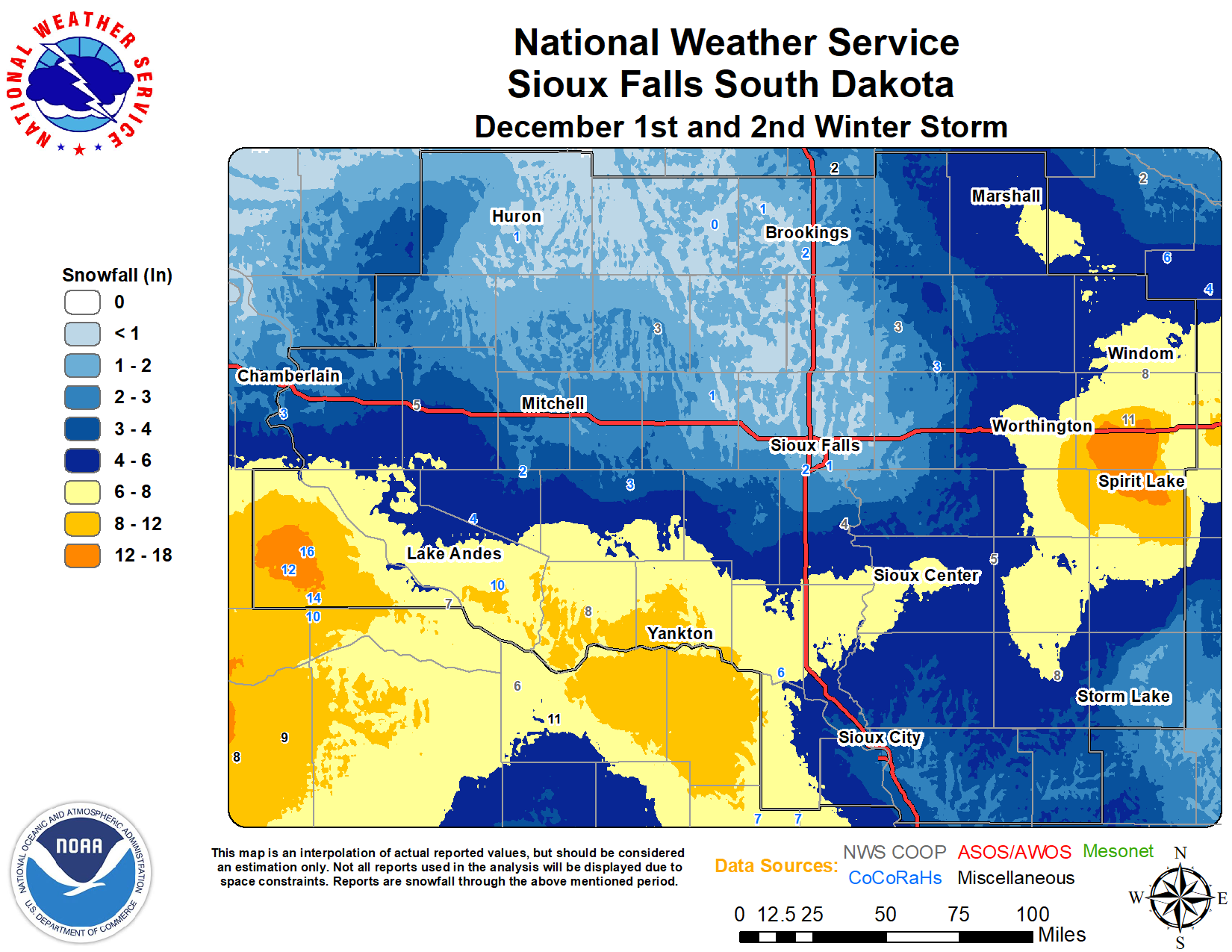 Observed Snowfall |
Snow/Ice
LOCATION AMOUNT TIME/DATE PROVIDER
2 NE BURKE 16.0 IN 0700 AM 12/02 COCORAHS
5 SSW HERRICK 14.0 IN 0700 AM 12/02 COCORAHS
2 NE LAKEFIELD 11.0 IN 0800 AM 12/02 CO-OP OBSERVER
1 NW WAGNER 10.5 IN 0700 AM 12/02 COCORAHS
8 SSW HERRICK 10.0 IN 0700 AM 12/02 COCORAHS
ASHTON 9.0 IN 0800 AM 12/02 PUBLIC
2 E YANKTON 9.0 IN 0700 AM 12/02 CO-OP OBSERVER
TYNDALL 8.3 IN 0700 AM 12/02 CO-OP OBSERVER
WINDOM 8.3 IN 0700 AM 12/02 CO-OP OBSERVER
4 N CURRIE 8.0 IN 0800 AM 12/02 AMATEUR RADIO
EMERSON 8.0 IN 0700 AM 12/02 CO-OP OBSERVER
6 S ALCESTER 8.0 IN 0700 AM 12/02 PUBLIC
CHEROKEE 8.0 IN 0700 AM 12/02 CO-OP OBSERVER
YANKTON 8.0 IN 0753 PM 12/01 PUBLIC
1 S ARMOUR 7.5 IN 0800 AM 12/02 EMERGENCY MNGR
4 SSW PICKSTOWN 7.2 IN 0800 AM 12/02 CO-OP OBSERVER
SPENCER 7.0 IN 0800 AM 12/02 CO-OP OBSERVER
VERMILLION 7.0 IN 0800 AM 12/02 PUBLIC
1 S MARSHALL 7.0 IN 0700 AM 12/02 COCORAHS
7 S AVON 7.0 IN 0700 AM 12/02 COCORAHS
1 SSW YANKTON 7.0 IN 0446 PM 12/01 PUBLIC
6 NNE ELK POINT 6.8 IN 0700 AM 12/02 COCORAHS
AKRON 6.6 IN 0700 AM 12/02 CO-OP OBSERVER
6 S CENTERVILLE 6.5 IN 0800 AM 12/02 PUBLIC
1 SE VERMILLION 6.3 IN 0700 AM 12/02 COCORAHS
WESTBROOK 6.0 IN 0840 AM 12/02 PUBLIC
6 WSW HINTON 6.0 IN 0800 AM 12/02 PUBLIC
6 NNW ETHAN 6.0 IN 0700 AM 12/02 COCORAHS
MARSHALL 6.0 IN 0700 AM 12/02 CO-OP OBSERVER
HAWARDEN 6.0 IN 0805 PM 12/01 PUBLIC
MINNEOTA 5.7 IN 0700 AM 12/02 PUBLIC
SIOUX CENTER 5.5 IN 0800 AM 12/02 PUBLIC
ORANGE CITY 5.5 IN 0700 AM 12/02 CO-OP OBSERVER
SHELDON 5.0 IN 0800 AM 12/02 CO-OP OBSERVER
6 S AVON 5.0 IN 0623 PM 12/01 PUBLIC
WHITE LAKE 4.8 IN 0700 AM 12/02 CO-OP OBSERVER
4 NW CURRIE 4.5 IN 0800 AM 12/02 PUBLIC
3 E BRUNSVILLE 4.5 IN 0800 AM 12/02 PUBLIC
LE MARS 4.5 IN 0742 PM 12/01 PUBLIC
1 N NORTH SIOUX CITY 4.0 IN 0800 AM 12/02 BROADCAST MEDIA
1 SE TEA 4.0 IN 0800 AM 12/02 PUBLIC
2 NNE WORTHINGTON 4.0 IN 0700 AM 12/02 CO-OP OBSERVER
SHELDON 4.0 IN 0429 PM 12/01 CO-OP OBSERVER
1 S KINGSLEY 3.8 IN 0700 AM 12/02 COCORAHS
VIBORG 3.5 IN 0540 PM 12/01 PUBLIC
2 W SERGEANT BLUFF 3.2 IN 0600 AM 12/02 OFFICIAL NWS OBS
2 NE BROOKINGS 3.1 IN 0800 AM 12/02 CO-OP OBSERVER
PIPESTONE 3.0 IN 0800 AM 12/02 CO-OP OBSERVER
2 E CLAYTON 3.0 IN 0800 AM 12/02 COCORAHS
7 SSW CHAMBERLAIN 3.0 IN 0700 AM 12/02 COCORAHS
EDGERTON 2.8 IN 0700 AM 12/02 COCORAHS
MITCHELL 2.6 IN 0700 AM 12/02 CO-OP OBSERVER
4 S ARTHUR 2.5 IN 0800 AM 12/02 PUBLIC
1 NE WALL LAKE 2.5 IN 0800 AM 12/02 COCORAHS
CHAMBERLAIN 2.3 IN 0700 AM 12/02 COCORAHS
9 NE WHITE 2.0 IN 0800 AM 12/02 COCORAHS
1 S BROOKINGS 2.0 IN 0800 AM 12/02 COCORAHS
ALEXANDRIA 2.0 IN 0700 AM 12/02 CO-OP OBSERVER
FORESTBURG 2.0 IN 0700 AM 12/02 COCORAHS
4 SSE SIOUX FALLS 1.5 IN 1040 PM 12/01 NWS EMPLOYEE
6 NW MONTROSE 1.3 IN 0700 AM 12/02 COCORAHS
NWS SIOUX FALLS 1.2 IN 0700 AM 12/02 OFFICIAL NWS OBS
1 S HURON 1.2 IN 0700 AM 12/02 COCORAHS
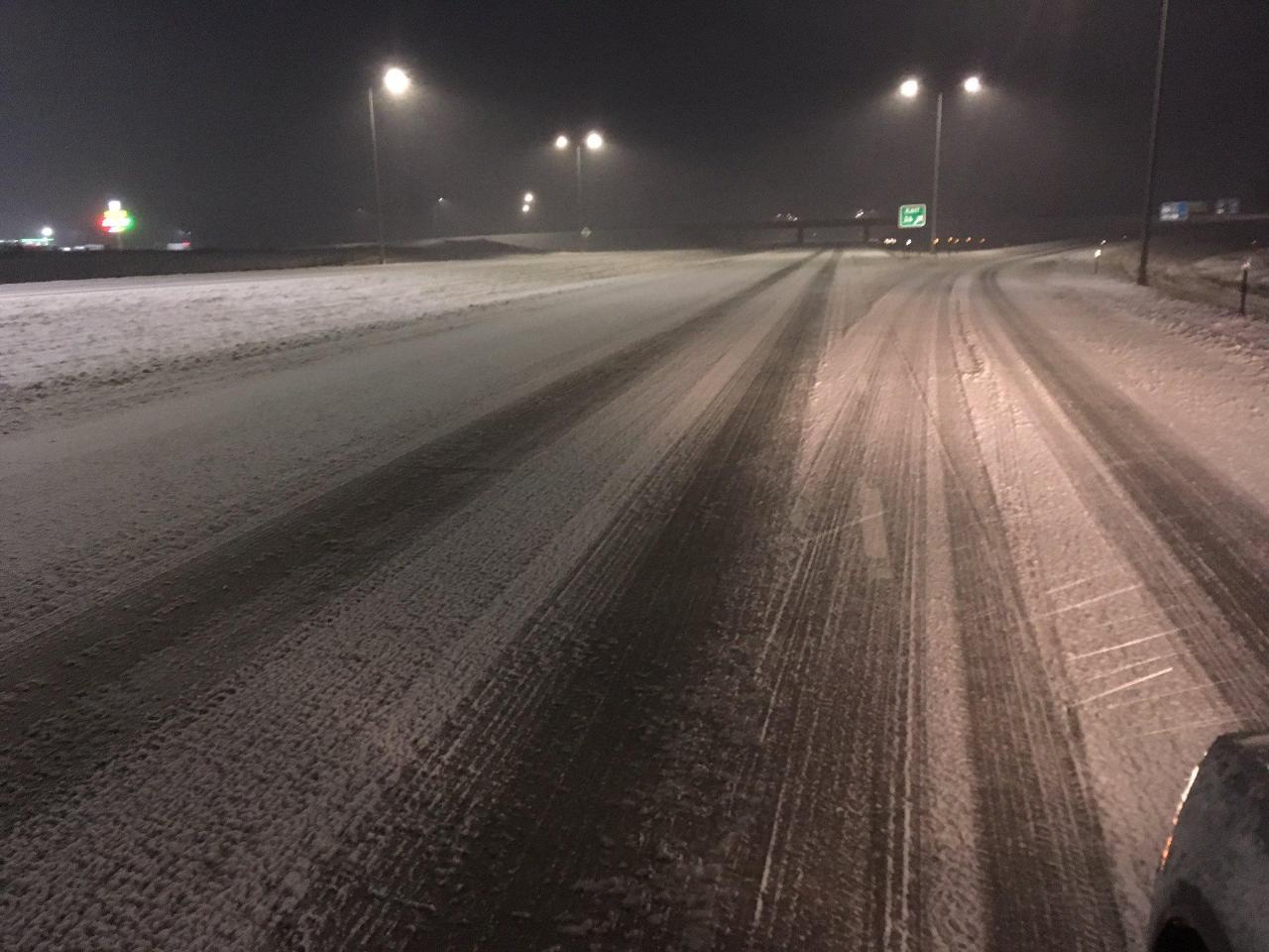
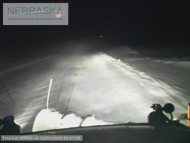
Photos & Video:
 |
 |
| Snow on I-29 Saturday Evening (Photo: SD Highway Patrol) |
Snow over Northeast Nebraska Highway Saturday Evening (Photo: NDOT) |
Radar:
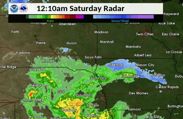 |
 |
| Storm Radar Summary | Water Vapor Imagery |
 |
Media use of NWS Web News Stories is encouraged! Please acknowledge the NWS as the source of any news information accessed from this site. |
|


 Weather Story
 Weather Map
 Local Radar