Overview
|
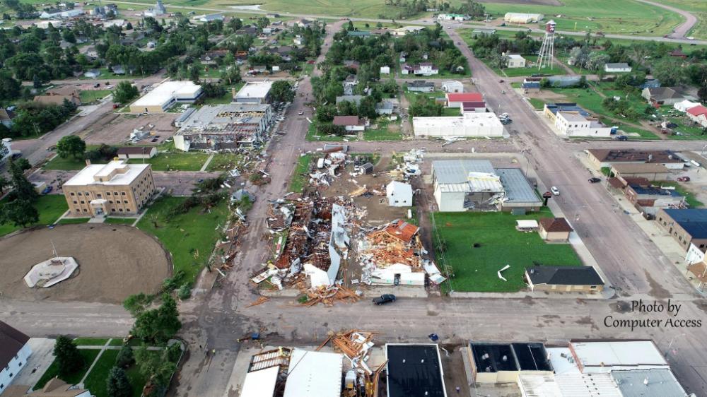
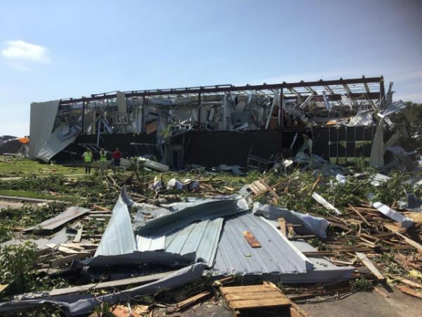
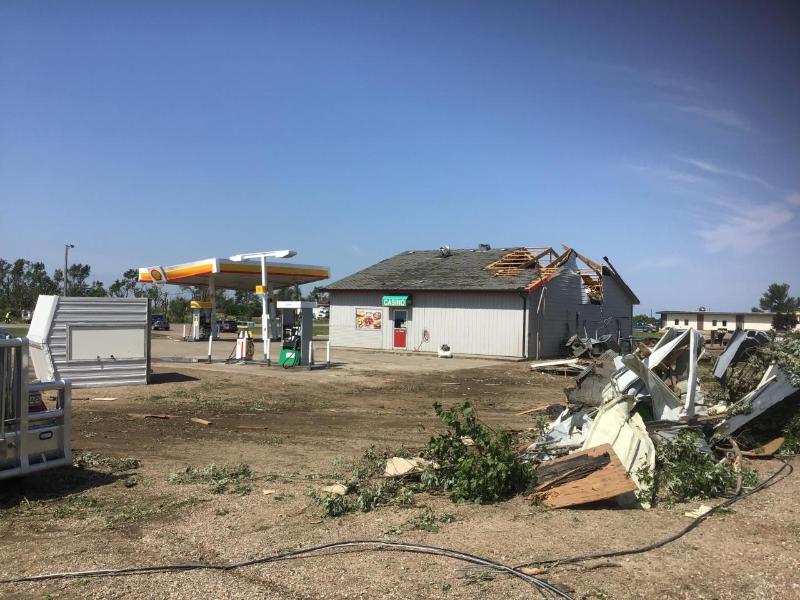
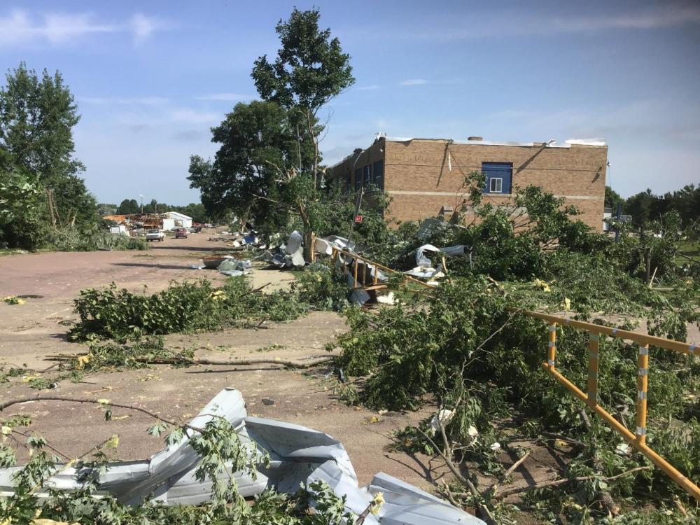
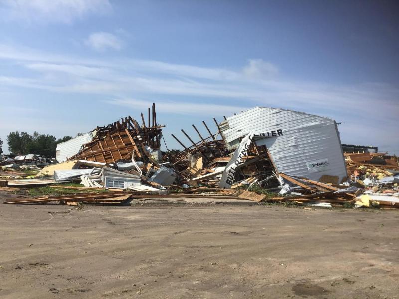
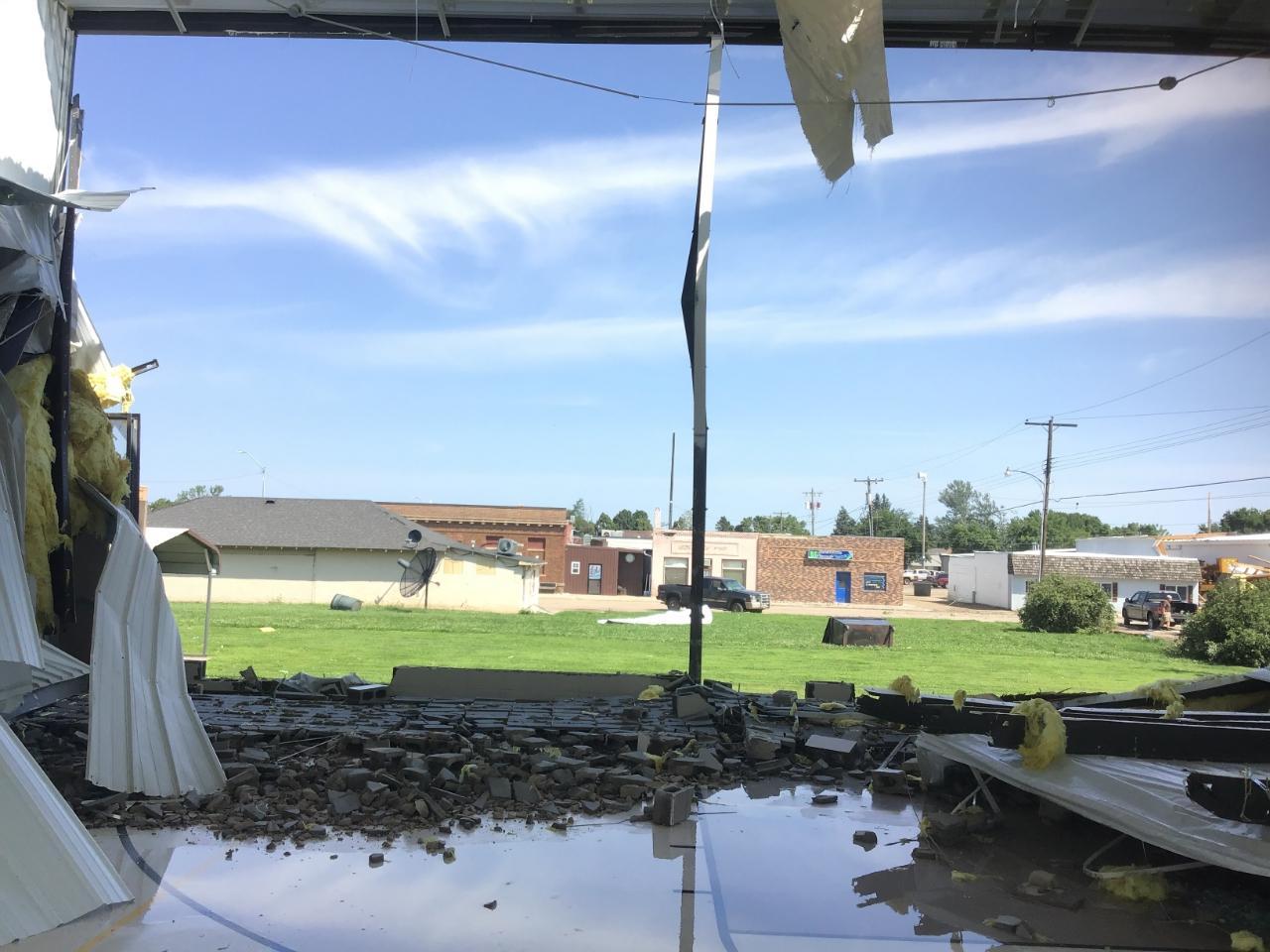
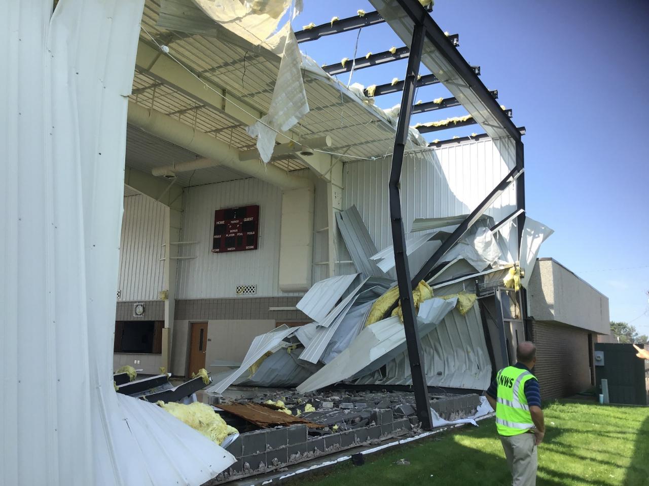
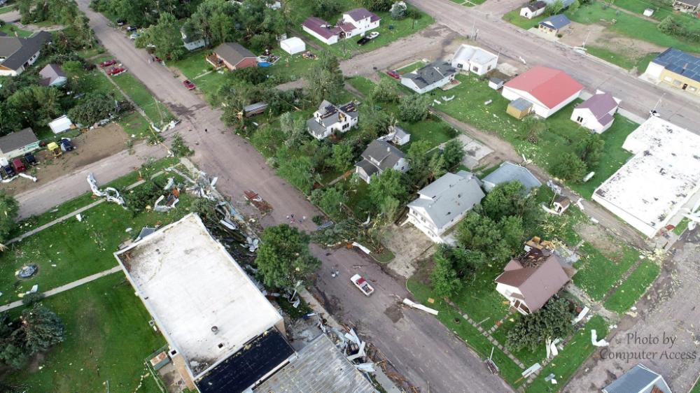
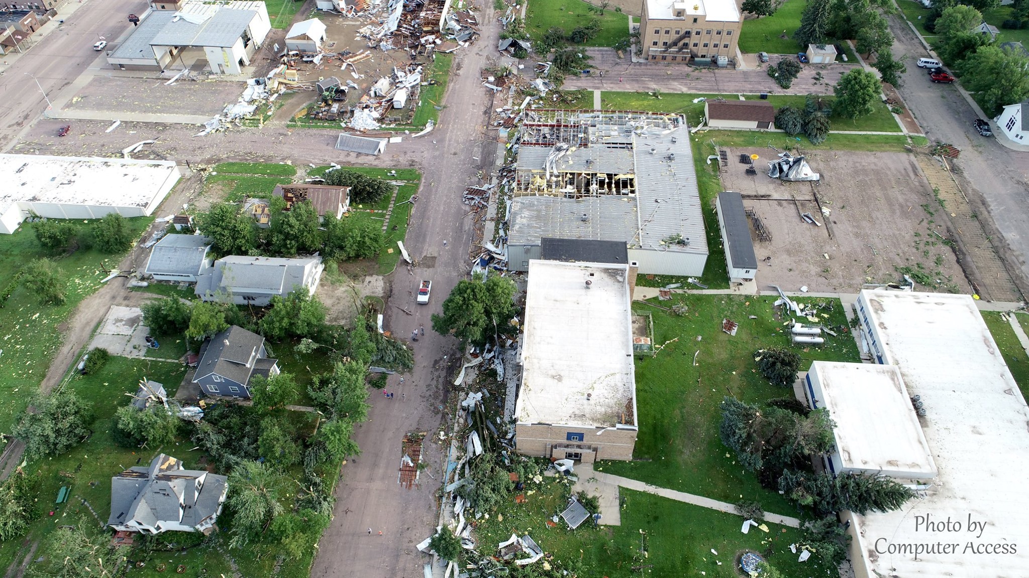
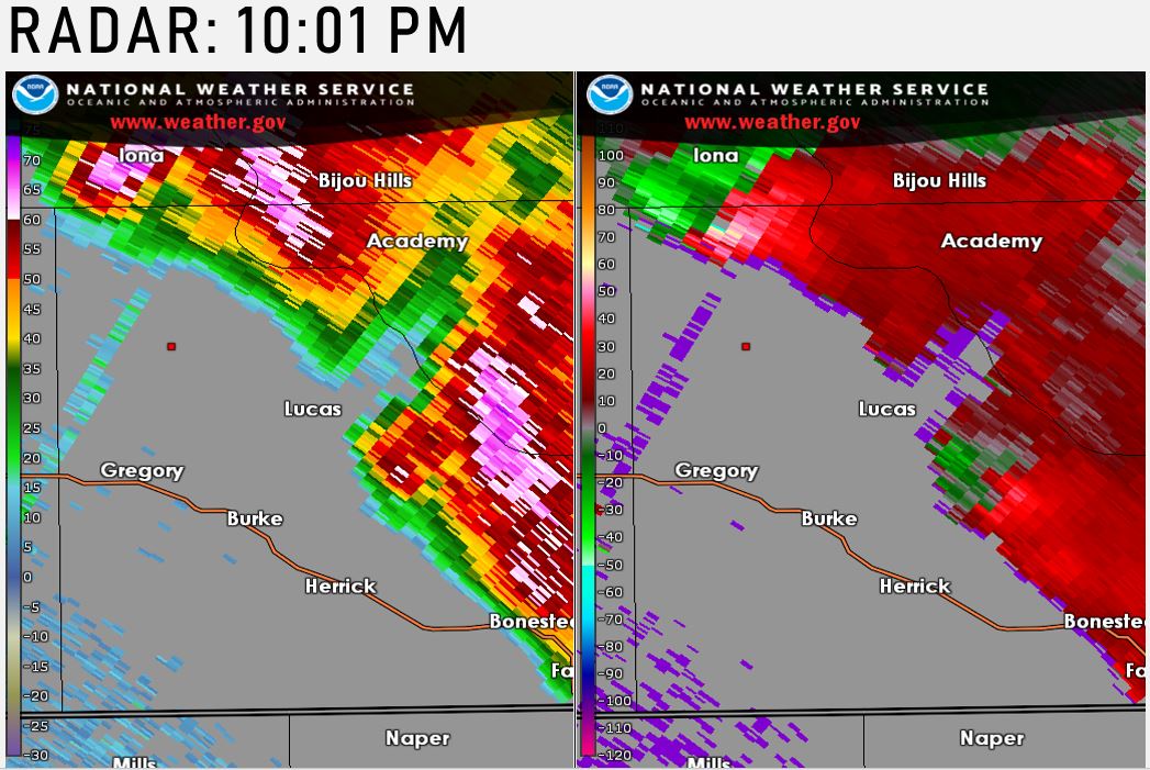
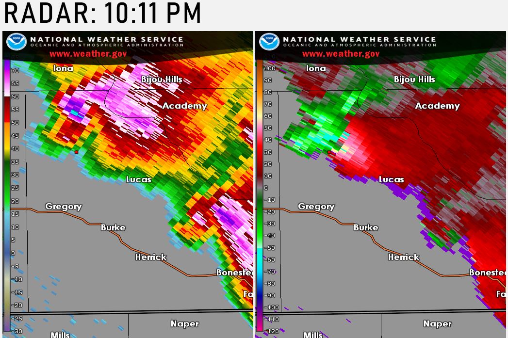
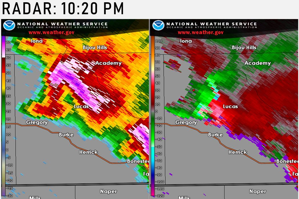
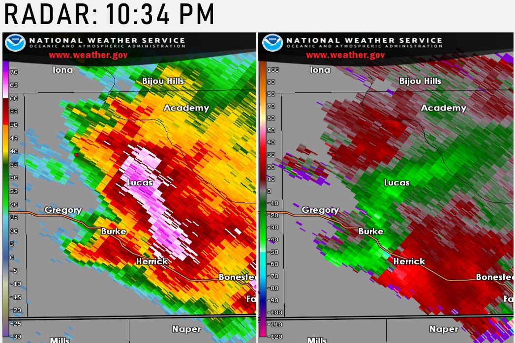
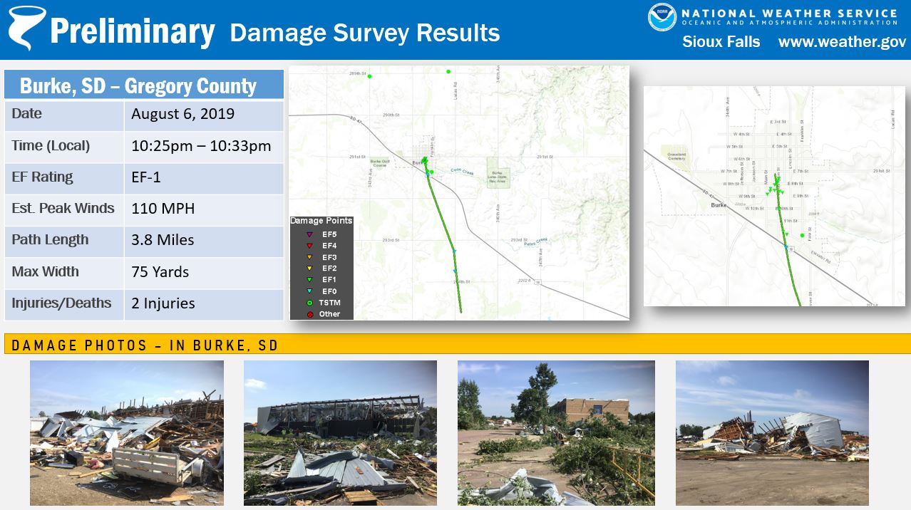
During the evening hours of August 6, 2019 a cluster of severe thunderstorms moved across central South Dakota and into northern Nebraska. These severe storms produced dangerous hail greater than 3" along with damaging straight line winds. As this storm moved into Gregory county in south central South Dakota, a tornado rapidly developed in the town of Burke. This tornado produced significant damage to portions of the city center, including the school, civic center, local lumberyard and many surrounding businesses and homes. NWS storm survey specialists rated this tornado as an EF-1, with peak wind speeds estimated at or near 110 MPH on the enhanced fujita scale. This tornado traveled an estimated 3.8 miles with a peak width of 75 yards. Two injuries were reported as this storm moved through the area. |
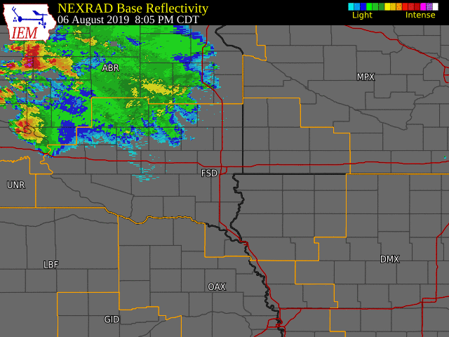 Radar Loop of Severe Storms |
 |
 |
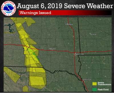 |
| Aerial Photo of Burke, SD | Severe Storm Arriving At Burke, SD | Summary of Issued Warnings |
Tornadoes
|
Tornado - BURKE, SD
|
||||||||||||||||
The Enhanced Fujita (EF) Scale classifies tornadoes into the following categories:
| EF0 Weak 65-85 mph |
EF1 Moderate 86-110 mph |
EF2 Significant 111-135 mph |
EF3 Severe 136-165 mph |
EF4 Extreme 166-200 mph |
EF5 Catastrophic 200+ mph |
 |
|||||
Photos & Video
Header
 |
 |
 |
 |
| Burke, SD (NWS Survey) |
Burke, SD (NWS Survey) |
Burke, SD (NWS Survey) |
Burke, SD (NWS Survey) |
 |
 |
 |
 |
| Burke, SD (NWS Survey) |
Burke, SD (NWS Survey) |
Burke, SD (NWS Survey) |
Burke, SD (NWS Survey) |
 |
 |
 |
|
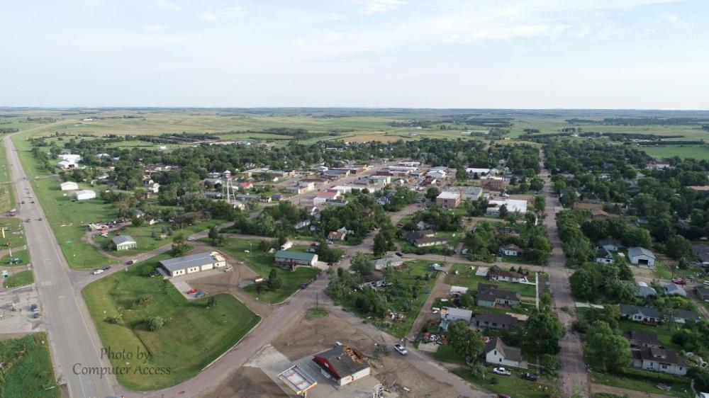
| Aerial Imagery (Computer Access) |
Aerial Imagery (Computer Access) |
Aerial Imagery (Computer Access) |
Aerial Imagery (Computer Access) |
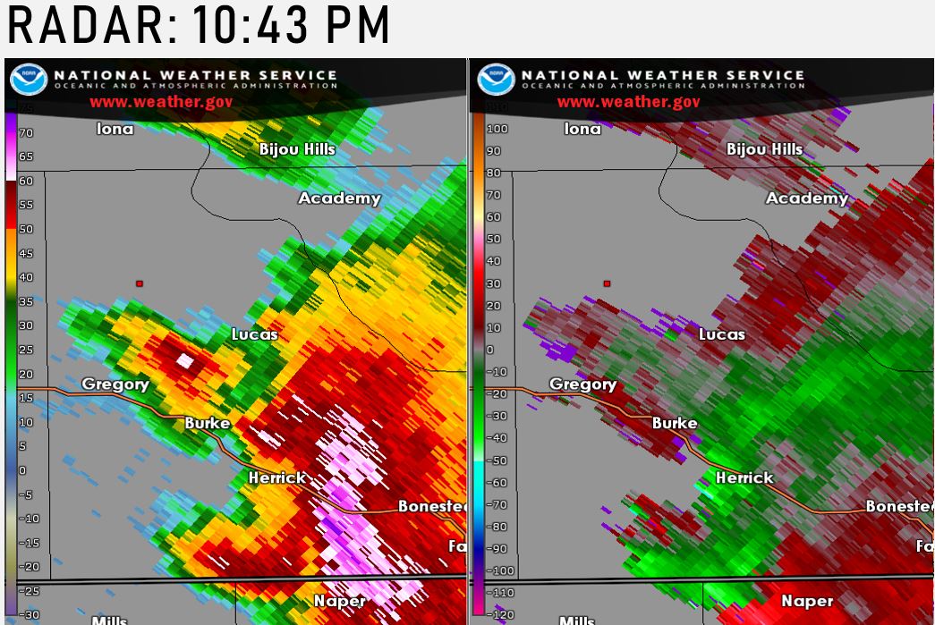
Radar
Header
 |
 |
 |
|
| 10:01PM | 10:11PM | 10:20PM | 10:28PM |
 |
 |
||
| 10:34PM | 10:43PM |
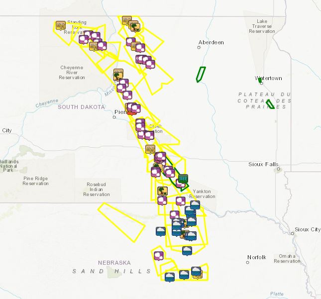
Storm Reports
Here is a look at local storm reports during the evening of August 6, 2019. Additional information will be shown as the page is updated.
 |
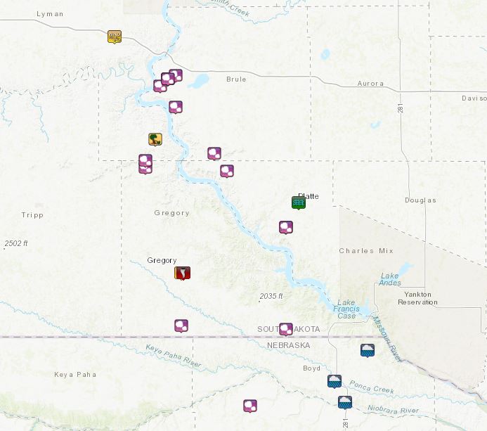 |
| Maps of Local Storm Reports | |
| Report Time | Location | ST | Event Type | Mag. | Source | Remark |
| Tue Aug 06 2019 21:00:00 GMT-0500 (Central Daylight Time) | 9 S Watauga | SD | TSTM WND GST | 60 | public | brief hail between nickel and quarter size. |
| Tue Aug 06 2019 21:25:00 GMT-0500 (Central Daylight Time) | 6 WSW Little Eagle | SD | HAIL | 1 | public | most hailstones between nickel and quarter size. |
| Tue Aug 06 2019 21:45:00 GMT-0500 (Central Daylight Time) | 5 SSE Little Eagle | SD | HAIL | 1 | public | ground became white with hail. |
| Tue Aug 06 2019 22:00:00 GMT-0500 (Central Daylight Time) | 3 N Trail City | SD | HAIL | 1 | public | depth of hail was 5 inches. corn crop was stripped. |
| Tue Aug 06 2019 22:02:00 GMT-0500 (Central Daylight Time) | 10 N Timber Lake | SD | HAIL | 0.5 | public | |
| Tue Aug 06 2019 22:04:00 GMT-0500 (Central Daylight Time) | 4 W Trail City | SD | TSTM WND GST | 59 | mesonet | |
| Tue Aug 06 2019 22:24:00 GMT-0500 (Central Daylight Time) | 5 E Trail City | SD | HAIL | 1 | public | 40 mph wind estimate. corn crop was stripped. |
| Tue Aug 06 2019 23:23:00 GMT-0500 (Central Daylight Time) | Whitlocks Bay Rec Area | SD | TSTM WND GST | 70 | public | 1.75 inch hail also reported. |
| Tue Aug 06 2019 23:25:00 GMT-0500 (Central Daylight Time) | 3 SSW Whitlocks Bay Rec | SD | TSTM WND DMG | 0 | public | winds estimated at at least 80 mph. hail as large as tennis balls, although most were smaller. hail accumulated in drifts that were 7 to 8 inches deep. wind driven hail shredded siding, many windows broken. trees were both uprooted and broken at the trunk and many very large branches are down. the roof of a nearby storage unit was partially torn off. |
| Tue Aug 06 2019 23:25:00 GMT-0500 (Central Daylight Time) | 2 N Herreid | SD | TSTM WND GST | 57 | mesonet | |
| Tue Aug 06 2019 23:35:00 GMT-0500 (Central Daylight Time) | 7 ESE Herreid | SD | TSTM WND GST | 60 | public | 3 inch diameter branch down. a few quarter size hail, but mostly dime to nickel size. |
| Tue Aug 06 2019 23:39:00 GMT-0500 (Central Daylight Time) | 4 WSW Gorman | SD | HAIL | 1.75 | trained spotter | all windows on north side of house broken out. |
| Tue Aug 06 2019 23:43:00 GMT-0500 (Central Daylight Time) | 6 W Agar | SD | HAIL | 1.75 | trained spotter | 18 inch diameter tree down on power lines. |
| Tue Aug 06 2019 23:43:00 GMT-0500 (Central Daylight Time) | 9 ENE Mound City | SD | TSTM WND DMG | 0 | public | garden crops damaged and some flattened. |
| Tue Aug 06 2019 23:50:00 GMT-0500 (Central Daylight Time) | Onida | SD | HAIL | 1.75 | public | |
| Wed Aug 07 2019 00:15:00 GMT-0500 (Central Daylight Time) | 4 SSE Blunt | SD | FUNNEL CLOUD | 0 | storm chaser | |
| Wed Aug 07 2019 00:18:00 GMT-0500 (Central Daylight Time) | 3 NE Selby | SD | HAIL | 1 | trained spotter | over 60 mph estimated as well. |
| Wed Aug 07 2019 00:20:00 GMT-0500 (Central Daylight Time) | 1 WSW Blunt | SD | TSTM WND GST | 78 | storm chaser | also measured 2.4 inch hail 20 minutes after it fell. |
| Wed Aug 07 2019 00:21:00 GMT-0500 (Central Daylight Time) | 1 E Blunt | SD | HAIL | 2.75 | trained spotter | golf ball to baseball sized hail fell from 1 mile west to 1 mile east of blunt. several reports of windows and siding broken. tree limbs down. winds estimated 60 to 65 mph. |
| Wed Aug 07 2019 00:28:00 GMT-0500 (Central Daylight Time) | 2 S Java | SD | HAIL | 1 | emergency mngr | mostly dime to nickel size hail with some quarter size. |
| Wed Aug 07 2019 00:30:00 GMT-0500 (Central Daylight Time) | 2 S Java | SD | HAIL | 2.75 | trained spotter | mostly golf ball size hail. vehicle windows shattered. |
| Wed Aug 07 2019 00:33:00 GMT-0500 (Central Daylight Time) | 2 S Java | SD | TSTM WND GST | 60 | emergency mngr | |
| Wed Aug 07 2019 00:40:00 GMT-0500 (Central Daylight Time) | 6 W Bowdle | SD | HAIL | 1 | emergency mngr | time estimated from radar. |
| Wed Aug 07 2019 00:47:00 GMT-0500 (Central Daylight Time) | 2 N Hoven | SD | HAIL | 1 | public | |
| Wed Aug 07 2019 00:48:00 GMT-0500 (Central Daylight Time) | 8 NNW West Bend Rec Are | SD | HAIL | 3 | storm chaser | many hail stones exceeding 3 inches in size. |
| Wed Aug 07 2019 00:50:00 GMT-0500 (Central Daylight Time) | 3 NE Hoven | SD | HAIL | 1.25 | public | mostly quarter size hail, some half dollar size. some garden crop damage. |
| Wed Aug 07 2019 01:04:00 GMT-0500 (Central Daylight Time) | 3 NNW Tolstoy | SD | HAIL | 0.88 | nws employee | |
| Wed Aug 07 2019 01:05:00 GMT-0500 (Central Daylight Time) | 5 SE Joe Creek Rec Area | SD | HAIL | 2.75 | trained spotter | mostly golf ball size hail with a few baseball size. |
| Wed Aug 07 2019 01:10:00 GMT-0500 (Central Daylight Time) | 3 ESE Tolstoy | SD | HAIL | 1 | public | |
| Wed Aug 07 2019 01:20:00 GMT-0500 (Central Daylight Time) | 1 E Blunt | SD | HAIL | 1.75 | trained spotter | |
| Wed Aug 07 2019 01:28:00 GMT-0500 (Central Daylight Time) | 5 ESE Blunt | SD | HAIL | 1.25 | public | quarter to half dollar size. no apparent damage noticeable. |
| Wed Aug 07 2019 01:45:00 GMT-0500 (Central Daylight Time) | 3 SE Reliance | SD | TSTM WND GST | 64 | mesonet | dot rwis. |
| Wed Aug 07 2019 01:55:00 GMT-0500 (Central Daylight Time) | 11 S Chamberlain | SD | HAIL | 0.88 | trained spotter | reported nickel size hail before the rain started, then nothing bigger than pea-size since then. |
| Wed Aug 07 2019 01:55:00 GMT-0500 (Central Daylight Time) | 6 SSW Chamberlain | SD | HAIL | 0.7 | trained spotter | lots of pea sized with some dime sized hail. otherwise just very heavy rain. |
| Wed Aug 07 2019 01:57:00 GMT-0500 (Central Daylight Time) | 8 SSW Chamberlain | SD | HAIL | 1 | trained spotter | |
| Wed Aug 07 2019 01:57:00 GMT-0500 (Central Daylight Time) | 6 SSW Chamberlain | SD | HAIL | 1 | trained spotter | hail stones have been increasing in size over the past 5 minutes. |
| Wed Aug 07 2019 02:00:00 GMT-0500 (Central Daylight Time) | 6 SSW Chamberlain | SD | HAIL | 1 | trained spotter | hail stones have been increasing in size over the past 5 minutes. |
| Wed Aug 07 2019 02:05:00 GMT-0500 (Central Daylight Time) | 4 NW West Bend Rec Area | SD | HAIL | 1 | public | |
| Wed Aug 07 2019 02:15:00 GMT-0500 (Central Daylight Time) | 6 SSW Chamberlain | SD | HAIL | 2 | trained spotter | |
| Wed Aug 07 2019 02:15:00 GMT-0500 (Central Daylight Time) | 6 SSW Platte | SD | HAIL | 2 | trained spotter | |
| Wed Aug 07 2019 02:15:00 GMT-0500 (Central Daylight Time) | Lower Brule | SD | TSTM WND GST | 60 | fire dept/rescue | |
| Wed Aug 07 2019 02:15:00 GMT-0500 (Central Daylight Time) | Lower Brule | SD | HAIL | 2.75 | fire dept/rescue | tennis ball to baseball size hail. window damage to vehicles and homes. |
| Wed Aug 07 2019 02:28:00 GMT-0500 (Central Daylight Time) | 18 S Pukwana | SD | HAIL | 1 | trained spotter | |
| Wed Aug 07 2019 02:42:00 GMT-0500 (Central Daylight Time) | 15 WNW Platte | SD | HAIL | 0.88 | trained spotter | nickel sized hail currently falling. |
| Wed Aug 07 2019 02:50:00 GMT-0500 (Central Daylight Time) | 6 SSW Platte | SD | HAIL | 0.88 | trained spotter | storm total rainfall so far at 1.00 inch. |
| Wed Aug 07 2019 02:54:00 GMT-0500 (Central Daylight Time) | 5 S Chamberlain | SD | HAIL | 1.75 | co-op observer | nickel up to golf ball sized hail fell. |
| Wed Aug 07 2019 02:57:00 GMT-0500 (Central Daylight Time) | 2 NE Iona | SD | TSTM WND DMG | 0 | public | trees down, shingles off homeowners roof. radar estimated time. |
| Wed Aug 07 2019 03:04:00 GMT-0500 (Central Daylight Time) | 3 SSW Iona | SD | HAIL | 2 | public | hail size is unknown, but it was large enough to damage siding, break windows, and severely damage crops. radar estimated time. |
| Wed Aug 07 2019 03:10:00 GMT-0500 (Central Daylight Time) | 7 NNE Dixon | SD | HAIL | 2.75 | public | hail destroyed windshield and headlights. no injuries. report relayed via spotter who came across the disabled vehicle and occupants. |
| Wed Aug 07 2019 03:16:00 GMT-0500 (Central Daylight Time) | Platte | SD | FLASH FLOOD | 0 | law enforcement | roads under water on the south side of platte, south of highway 44. |
| Wed Aug 07 2019 03:18:00 GMT-0500 (Central Daylight Time) | 8 SW Herrick | SD | HAIL | 0.7 | trained spotter | estimating wind gusts up to 50 mph. |
| Wed Aug 07 2019 03:25:00 GMT-0500 (Central Daylight Time) | Burke | SD | TORNADO | 0 | nws storm survey | *** 2 inj *** widespread 80 to 100 mph winds were reported across burke. an ef-1 tornado touched down in burke with path width of 75 yards and path length of 3.8 miles. |
| Wed Aug 07 2019 03:30:00 GMT-0500 (Central Daylight Time) | Burke | SD | TSTM WND GST | 70 | trained spotter | at least six large pine, spruce, and cedar trees down in yard. |
| Wed Aug 07 2019 03:30:00 GMT-0500 (Central Daylight Time) | Burke | SD | TSTM WND GST | 70 | trained spotter | building debris scattered across the highway. |
| Wed Aug 07 2019 03:30:00 GMT-0500 (Central Daylight Time) | Burke | SD | TSTM WND DMG | 0 | fire dept/rescue | very strong wind gust has caused tree branches to come down, and burke lost power for a couple minutes. |
| Wed Aug 07 2019 03:39:00 GMT-0500 (Central Daylight Time) | Fairfax | SD | HAIL | 0.5 | trained spotter | |
| Wed Aug 07 2019 04:00:00 GMT-0500 (Central Daylight Time) | Spencer | NE | TSTM WND DMG | 0 | broadcast media | large branches downed. time estimated from radar |
| Wed Aug 07 2019 04:03:00 GMT-0500 (Central Daylight Time) | 15 NNE Stuart | NE | HAIL | 2 | public | report via social media with picture. |
| Wed Aug 07 2019 04:20:00 GMT-0500 (Central Daylight Time) | 13 NE Atkinson | NE | TSTM WND DMG | 0 | broadcast media | grain bin damage... top caved in from wind. time estimated from radar |
| Wed Aug 07 2019 04:30:00 GMT-0500 (Central Daylight Time) | 16 N Oneill | NE | TSTM WND DMG | 0 | broadcast media | trees downed blocking road. time estimated from radar |
| Wed Aug 07 2019 04:30:00 GMT-0500 (Central Daylight Time) | 10 N Atkinson | NE | TSTM WND DMG | 0 | broadcast media | trees down. camper moved a few feet and has window damage. time estimated from radar |
| Wed Aug 07 2019 04:40:00 GMT-0500 (Central Daylight Time) | Emmet | NE | TSTM WND DMG | 0 | law enforcement | report of tree and powerlines down along highway near emmet |
| Wed Aug 07 2019 05:02:00 GMT-0500 (Central Daylight Time) | Oneill | NE | TSTM WND GST | 58 | awos | |
| Wed Aug 07 2019 06:21:00 GMT-0500 (Central Daylight Time) | 4 SSE Bartlett | NE | TSTM WND GST | 59 | mesonet | |
| Wed Aug 07 2019 06:50:00 GMT-0500 (Central Daylight Time) | 8 ESE Rose | NE | HAIL | 1 | public | dime to quarter size hail. 2.10 inches of rain |
| Wed Aug 07 2019 12:00:00 GMT-0500 (Central Daylight Time) | Burwell | NE | HEAVY RAIN | 1.37 | cocorahs | |
| Wed Aug 07 2019 12:00:00 GMT-0500 (Central Daylight Time) | 5 SSE Spencer | NE | HEAVY RAIN | 1.64 | co-op observer | |
| Wed Aug 07 2019 12:00:00 GMT-0500 (Central Daylight Time) | 8 WNW Ericson | NE | HEAVY RAIN | 1.22 | co-op observer | |
| Wed Aug 07 2019 12:00:00 GMT-0500 (Central Daylight Time) | 2 W Oneill | NE | HEAVY RAIN | 1.31 | awos | |
| Wed Aug 07 2019 12:00:00 GMT-0500 (Central Daylight Time) | 16 N Oneill | NE | HEAVY RAIN | 1.75 | broadcast media | |
| Wed Aug 07 2019 12:00:00 GMT-0500 (Central Daylight Time) | SW Chambers | NE | HEAVY RAIN | 2.8 | broadcast media | |
| Wed Aug 07 2019 12:00:00 GMT-0500 (Central Daylight Time) | 20 NW Oneill | NE | HEAVY RAIN | 1.8 | broadcast media | |
| Wed Aug 07 2019 12:00:00 GMT-0500 (Central Daylight Time) | S Oneill | NE | HEAVY RAIN | 1.6 | broadcast media | |
| Wed Aug 07 2019 12:00:00 GMT-0500 (Central Daylight Time) | SW Atkinson | NE | HEAVY RAIN | 1.5 | broadcast media | |
| Wed Aug 07 2019 12:00:00 GMT-0500 (Central Daylight Time) | N Atkinson | NE | HEAVY RAIN | 1.2 | broadcast media | |
| Wed Aug 07 2019 12:00:00 GMT-0500 (Central Daylight Time) | Spencer | NE | HEAVY RAIN | 1.6 | broadcast media | |
| Wed Aug 07 2019 12:00:00 GMT-0500 (Central Daylight Time) | 10 N Atkinson | NE | HEAVY RAIN | 1.6 | broadcast media | |
| Wed Aug 07 2019 12:00:00 GMT-0500 (Central Daylight Time) | Oneill | NE | HEAVY RAIN | 1.65 | co-op observer | |
| Wed Aug 07 2019 13:00:00 GMT-0500 (Central Daylight Time) | 7 N Atkinson | NE | HEAVY RAIN | 1.15 | broadcast media | |
| Wed Aug 07 2019 13:00:00 GMT-0500 (Central Daylight Time) | 1 N Gross | NE | HEAVY RAIN | 1.35 | broadcast media | |
| Wed Aug 07 2019 13:00:00 GMT-0500 (Central Daylight Time) | 5 S Newport | NE | HEAVY RAIN | 1.22 | broadcast media | |
| Wed Aug 07 2019 13:00:00 GMT-0500 (Central Daylight Time) | NE Bartlett | NE | HEAVY RAIN | 1.52 | broadcast media |
 |
Media use of NWS Web News Stories is encouraged! Please acknowledge the NWS as the source of any news information accessed from this site. |
|


 Weather Story
 Weather Map
 Local Radar