Overview
|
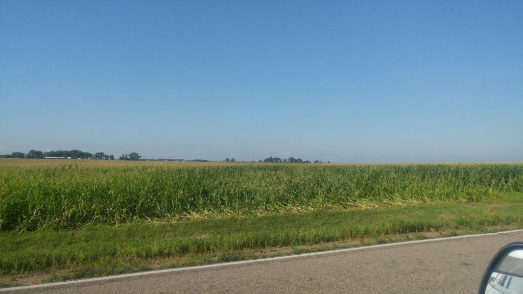
Severe thunderstorms formed across central South Dakota during the late afternoon. As these storms moved across southeastern South Dakota, they formed into a squall line and produced large hail and damaging winds. As the storms moved east of I-29, several tornadoes were produced by the storms. One EF-1 tornado went through Hadley, Minnesota and a second EF-1 tornado moved west and south of Rock Rapids, Iowa. Five EF-0 tornadoes also touched down in Nobles, Murray, and Cottonwood Counties in Minnesota. These tornadoes primarily did damage to crops and trees although a few homes and farm buildings were damaged. In addition, winds up to 90 mph moved through Okoboji Iowa causing tree damage as well as damage to a few homes and an office building. |
 Supercell which produced 2 inch hail near Lake Andes, SD. (Julie Weddell) |
 |
 |
 |
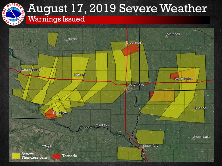
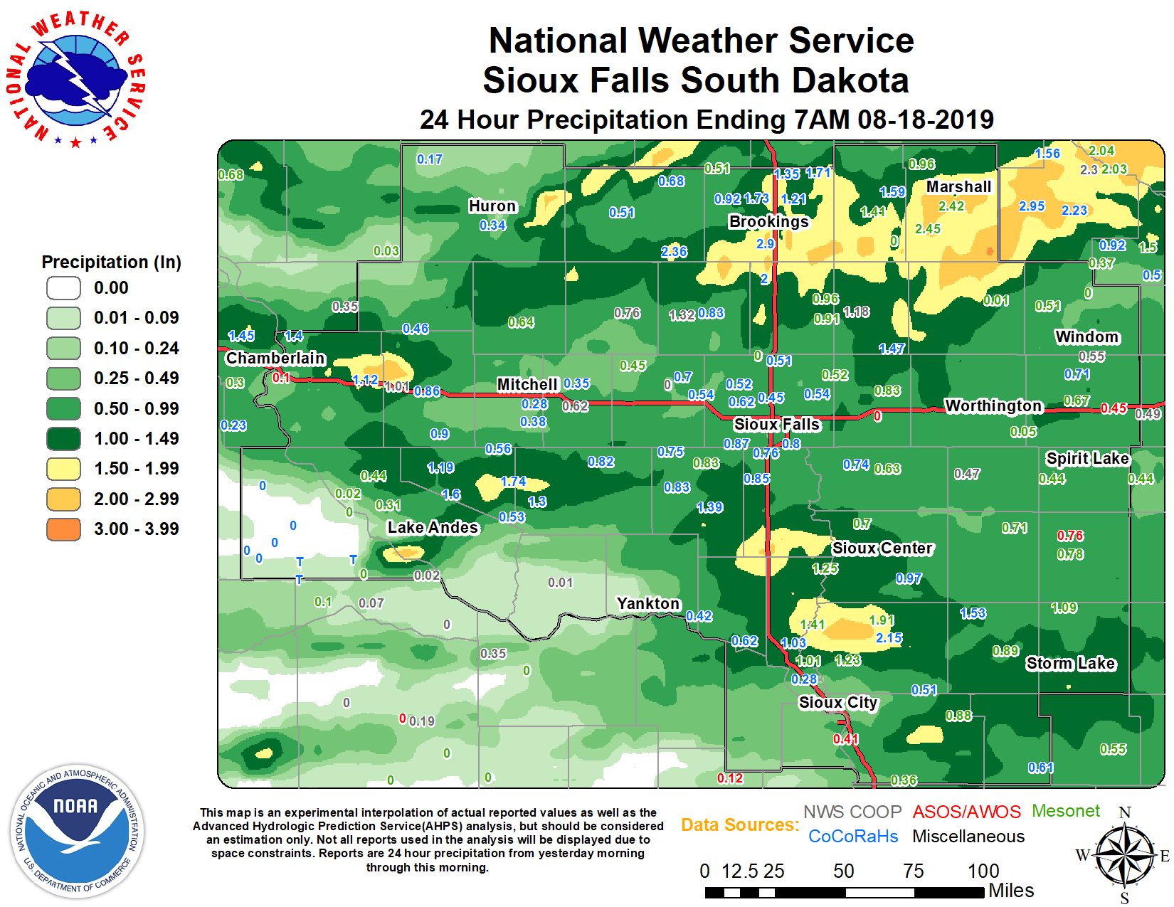
| Summary of Warnings Issued | Map of 24-hour Rainfall | Shelf Cloud near Mitchell, SD |
Tornadoes:
|
Tornado - Hadley, Minnesota
Track Map 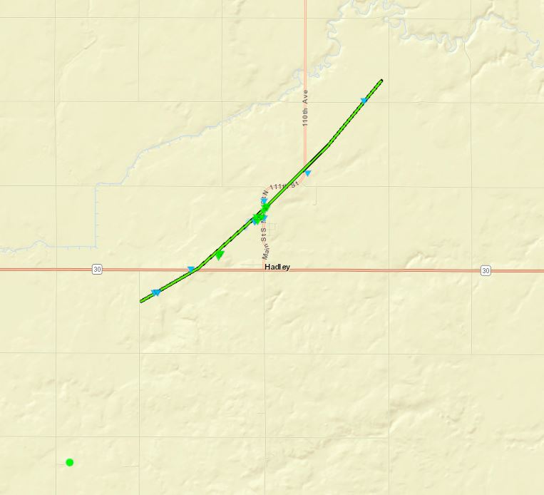 
Downloadable KMZ File |
||||||||||||||||
|
Tornado - Rock Rapids, Iowa
Track Map 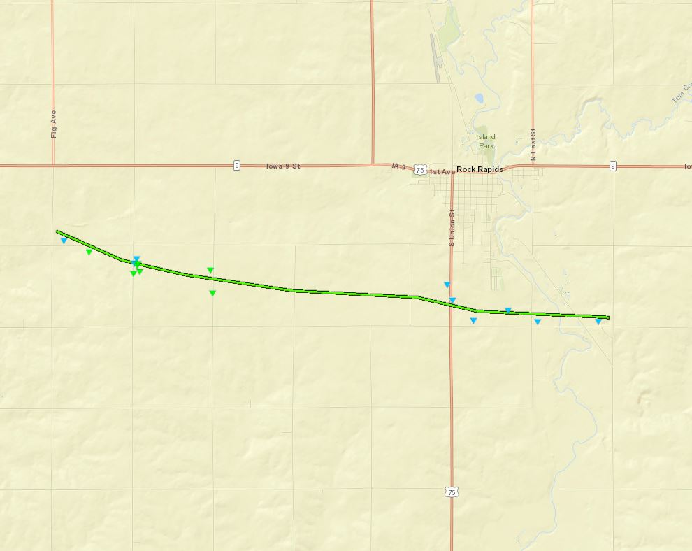
Downloadable KMZ File
|
||||||||||||||||
|
Tornado - Reading, MInnesota
Track Map 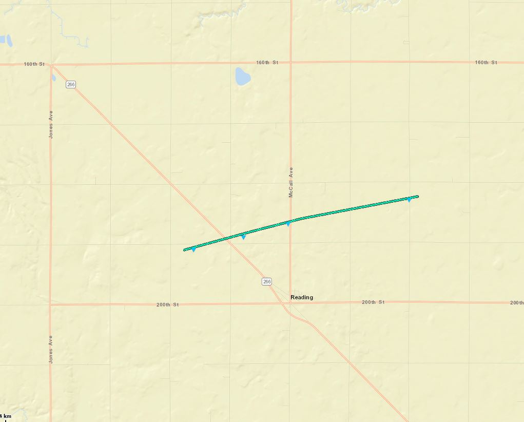
Downloadable KMZ File
|
||||||||||||||||
|
Tornado - Iona, MInnesota
Track Map 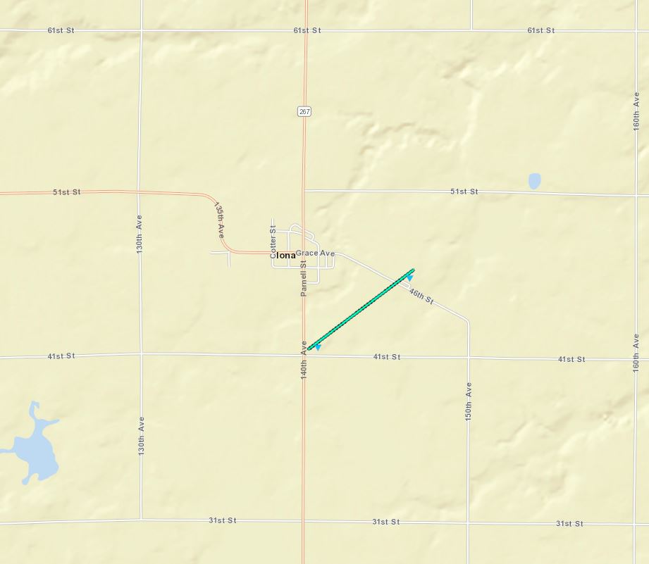
Downloadable KMZ File
|
||||||||||||||||
|
Tornado - Rural Murray County
Track Map 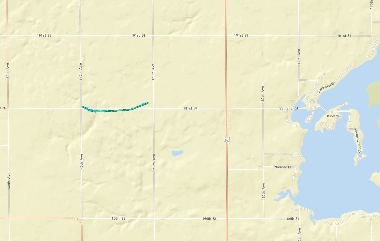
Downloadable KMZ File
|
||||||||||||||||
|
Tornado - Lake Sarah
Track Map 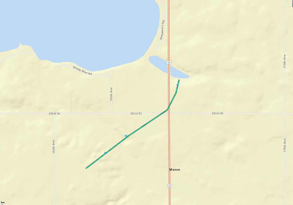
Downloadable KMZ File
|
||||||||||||||||
|
Tornado - Rural Cottonwood County
Track Map 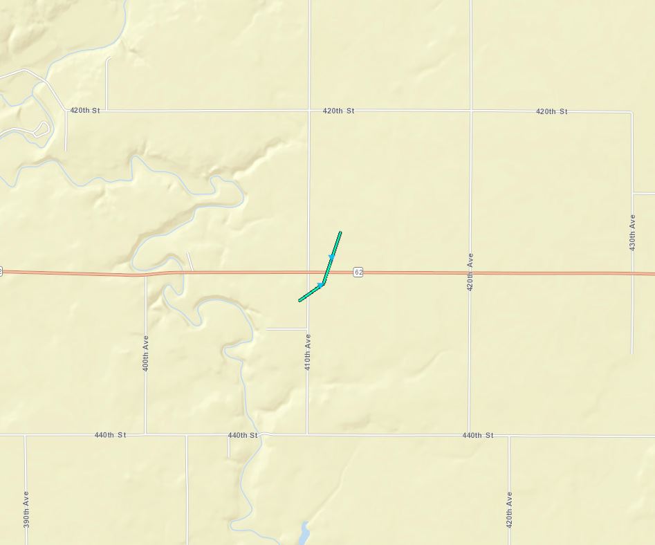
Downloadable KMZ File
|
||||||||||||||||
The Enhanced Fujita (EF) Scale classifies tornadoes into the following categories:
| EF0 Weak 65-85 mph |
EF1 Moderate 86-110 mph |
EF2 Significant 111-135 mph |
EF3 Severe 136-165 mph |
EF4 Extreme 166-200 mph |
EF5 Catastrophic 200+ mph |
 |
|||||
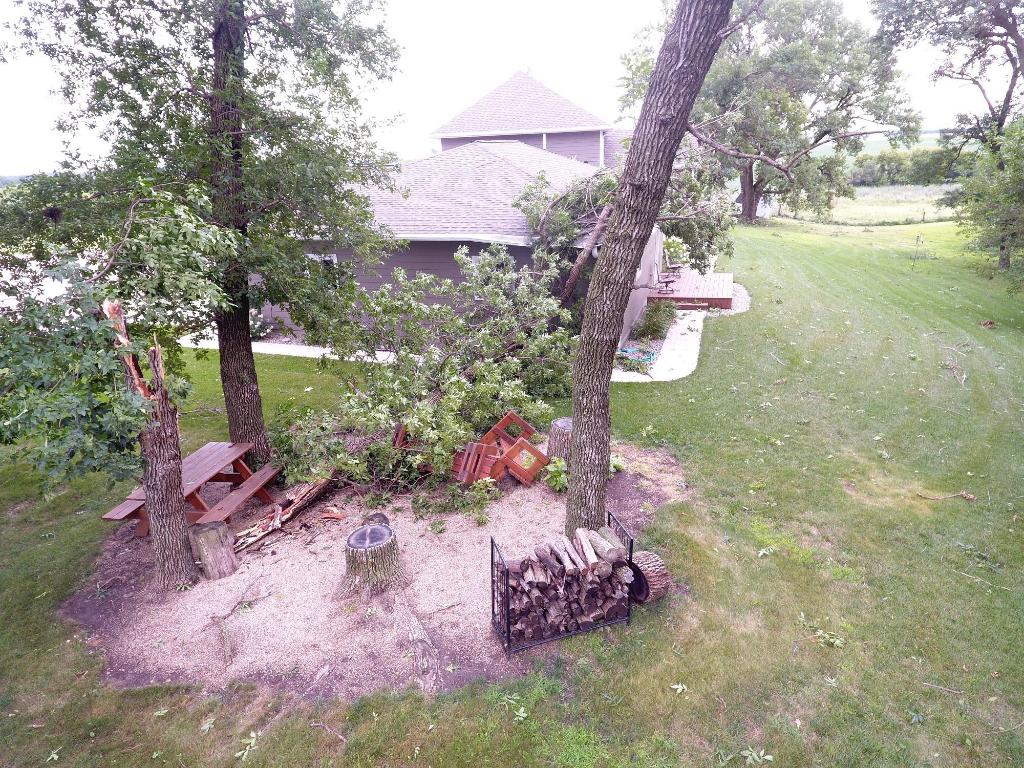
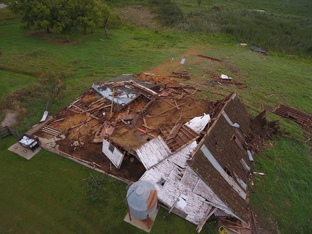
Photos & Video
Tornado, Large Hail, and Wind Damage
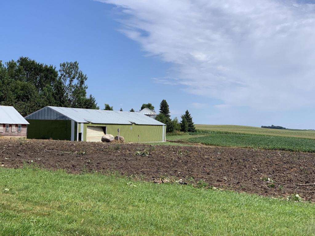
| Damage Photos from Rock Rapids, Tornado (EF-1) | |||
 |
 |
 |
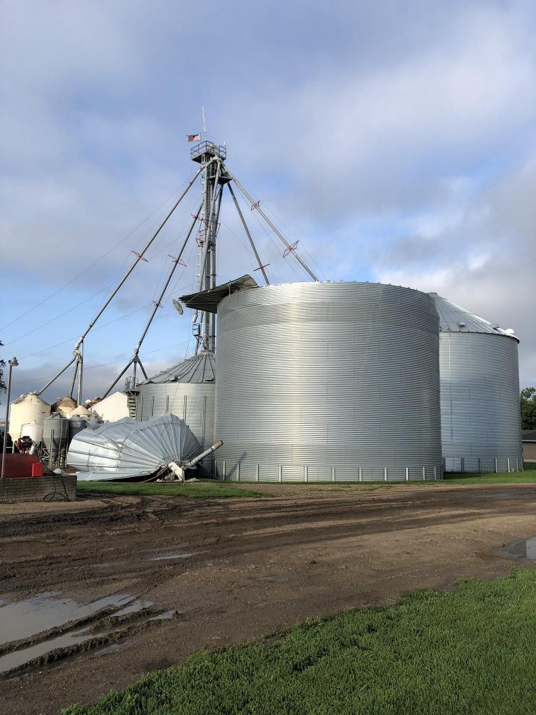 |
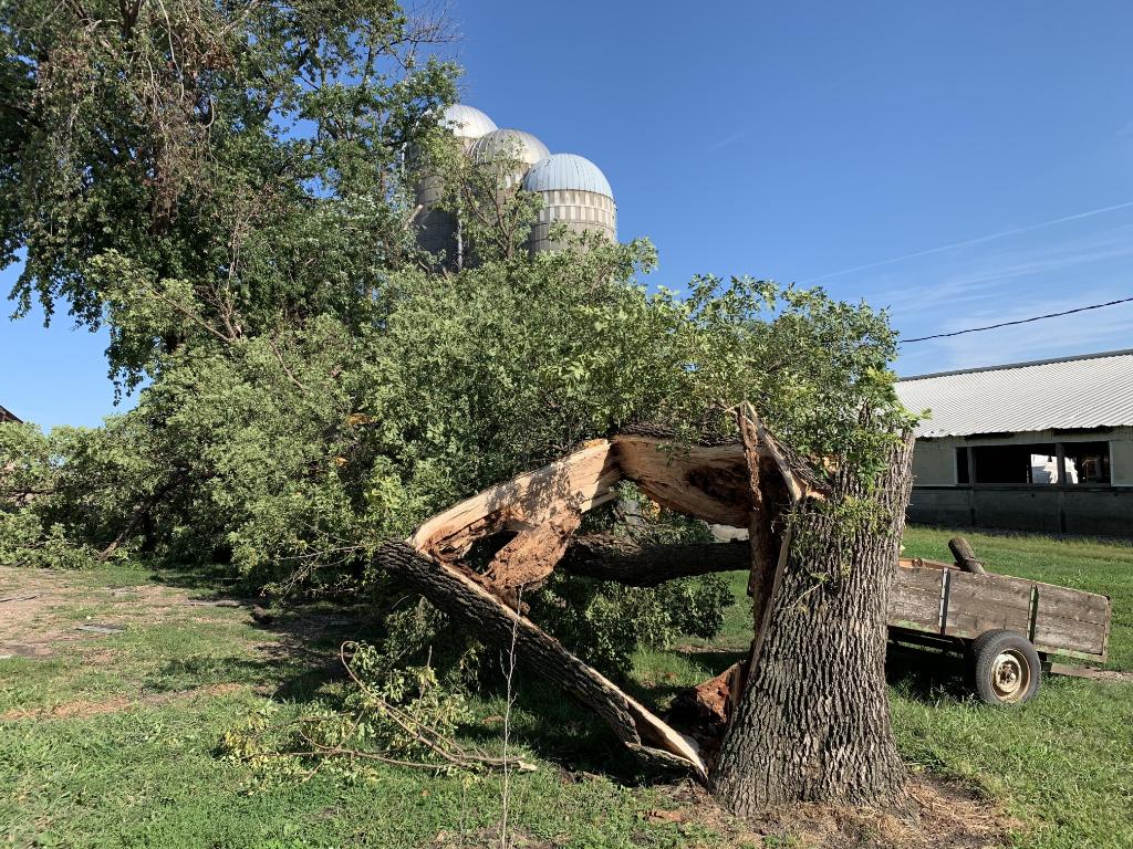
| Damaged silo near Rock Rapids (JD Hommes) |
Tree damage near Rock Rapids (JD Hommes) |
Damage to cow confinement near Rock Rapids | Grain bin damage near Rock Rapids (Anonymous) |
 |
 |
 |
 |
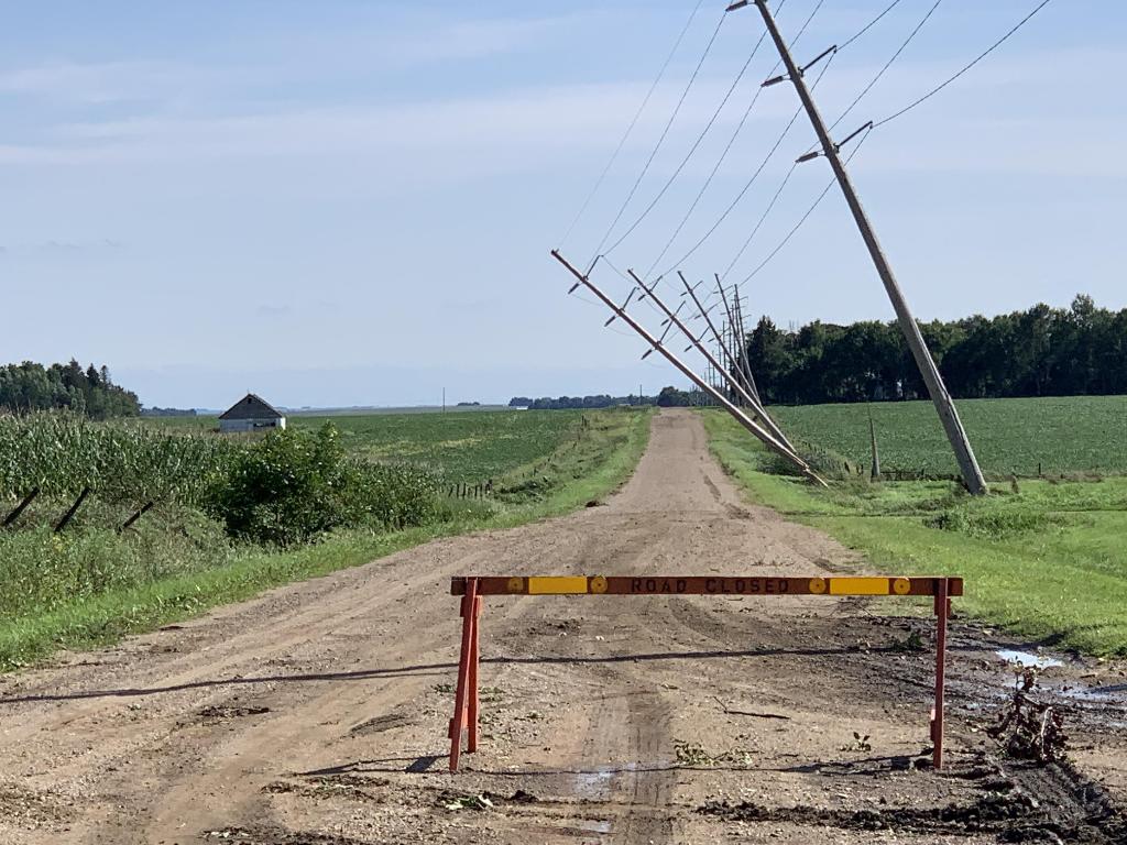
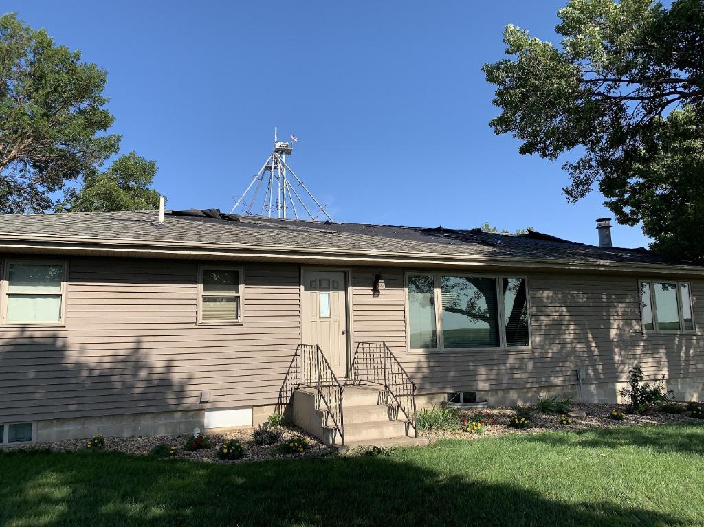
| Damage to hog confinement near Rock Rapids | One power pole was snapped and 4 others leaning near Rock Rapids. | Numerous shingles removed from roof near Rock Rapids. | Tree snapped near Rock Rapids. |
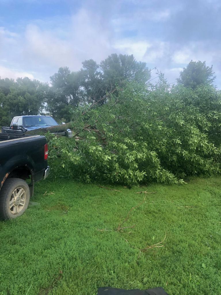
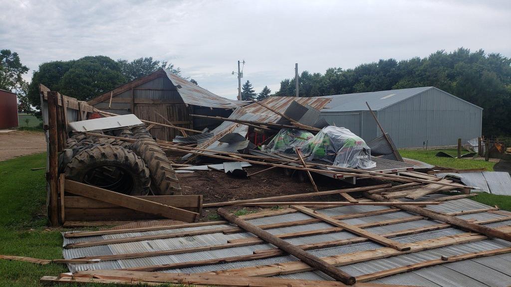
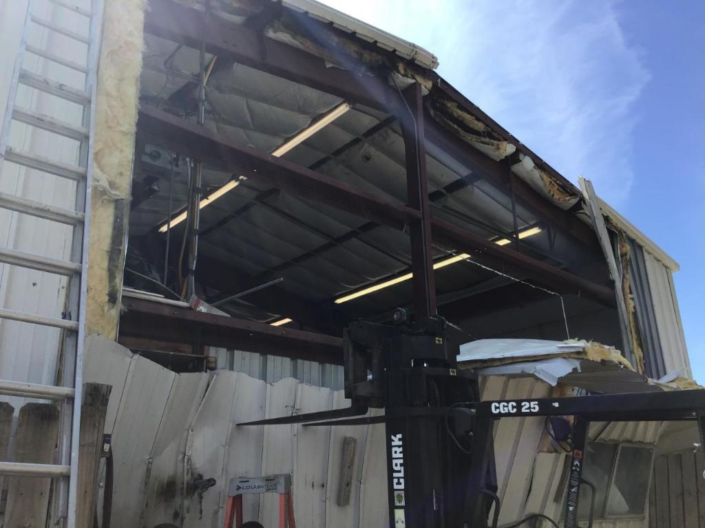
| Damage Photos from Hadley, Tornado (EF-1) | |||
 |
 |
 |
 |
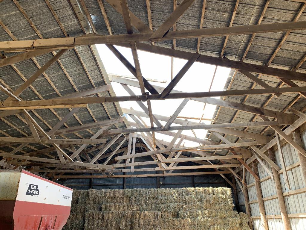
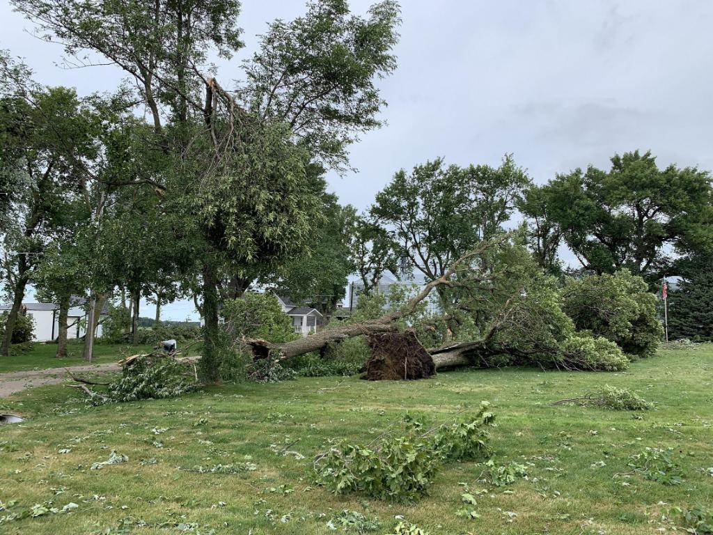
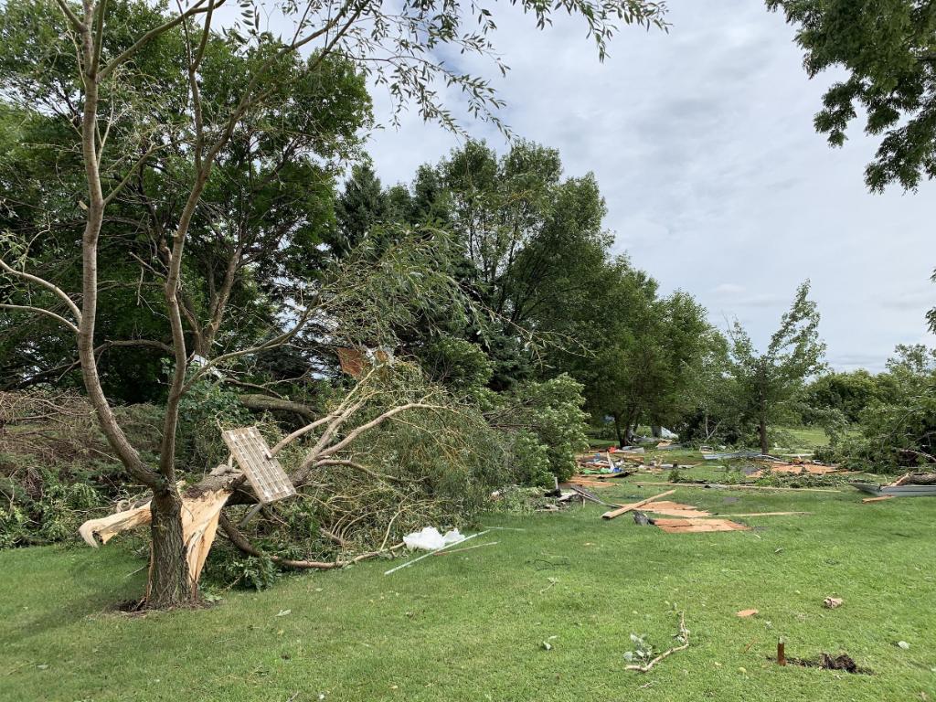
| Roof damage to shed near Hadley. Several trusses were also broken. | Tree damage and numerous broken branches in Hadley | Trees uprooted in Hadley | Additional tree damage in Hadley |
 |
 |
 |
 |
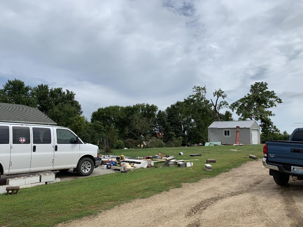
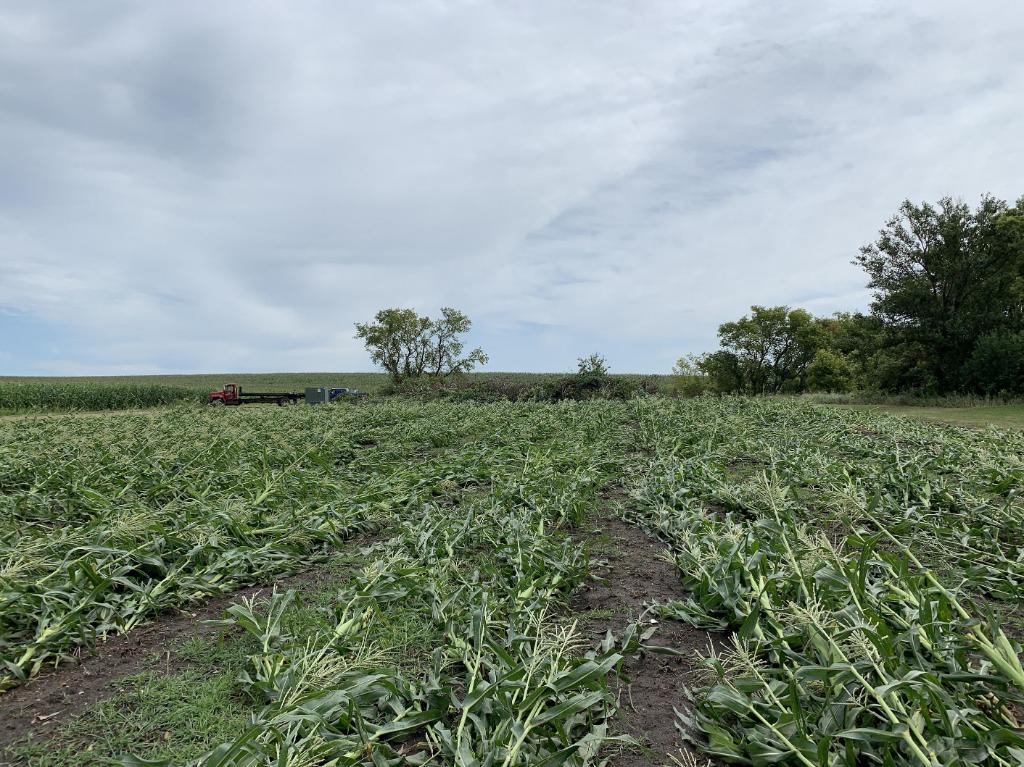
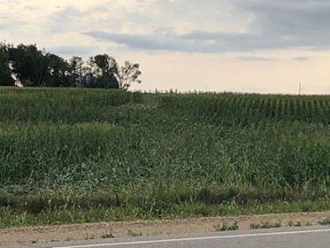
| Garage destroyed with van remaining on concrete slab where the garage had been. | Trees snapped in foreground. Debris from destroyed garage can be seen on the grass. | Flattened corn near Hadley. Note the corn in the background turns right (southeast) toward the tornado track. | Outbuilding with door damaged. |
| Damage Photos from Reading, Minnesota Tornado (EF-0) | Damage Photo from Lake Sarah, Minnesota Tornado (EF-0) | ||
 |
 |
 |
 |
| Flattened corn near Reading, MN (James Joens) |
Damage to roof near Reading, Minnesota | Damage to outbuilding near Lake Sarah, Minnesota (Parker McNeil) | Corn flattened south of Lake Sarah (Parker McNeil) |
| Damage Photos from Iona, Minnesota Tornado (EF-0) | Damage Photos from rural Murray County, Minnesota Tornado (EF-0) | ||
 |
 |
 |
 |
| Corn flattened. Photo was taken two days after tornado. (Brad Gass) | Pine tree snapped half way up and several headstones were toppled (Brad Gass) | Tree snapped and landing on house, damaging roof. (Timothy Moline) | Shed destroyed (Timothy Moline) |
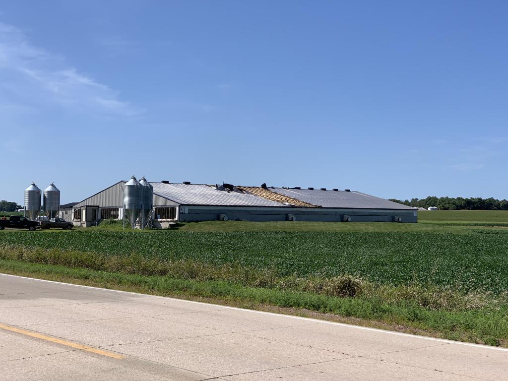
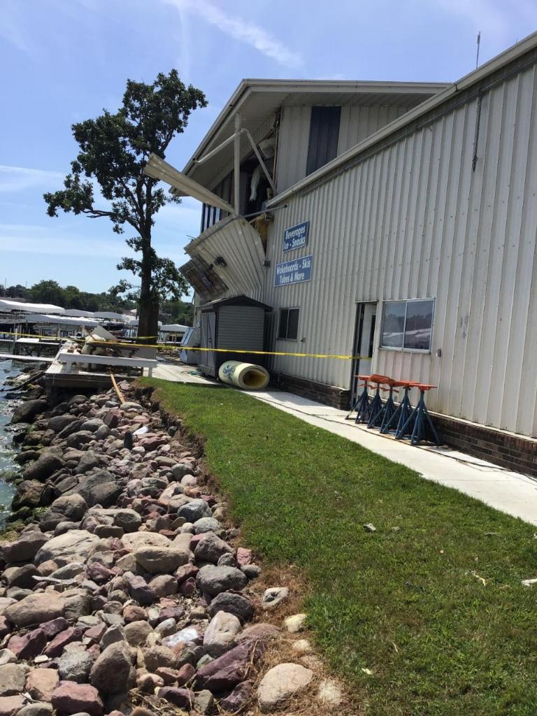
| Wind damage photos from Wahpeton and Okoboji, Iowa | |||
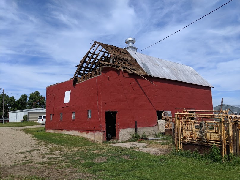 |
 |
 |
 |
| Barn roof partially taken off. (Mike Ehret) | Tin from barn roof wrapped around tree to the east of the barn. (Mike Ehret) | Roof to home damaged by fallen branch. | Tree snapped with other branches removed from trees in the background. |
 |
 |
 |
.jpg) |
| Garage door was partially blown in and 3 windows were blown in on the second floor. | North wall of warehouse blown out after west facing garage door gives way. | Second floor east wall blown out as a result of windows giving way on the west side of building. | Roof damaged by large limb falling on ti. |
| Other damage photos | |||
.jpg) |
 |
 |
 |
| Corn flattened by tornado 7 miles west of Windom, Minnesota (Paul Johnson) |
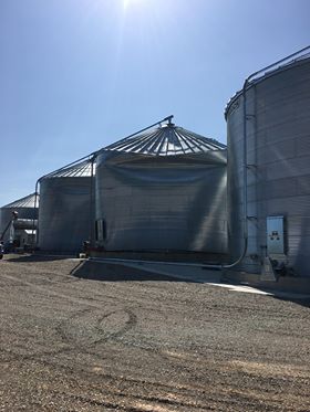
Grain bin damaged by 80-85 mph winds near Sibley, Iowa (Rochelle Jacobsma) |
Trees branches down in Pipestone, Minnesota (Pipestone Star newspaper) |
Large hail near Lake Andes (Rachel Bergin Kaczor) |
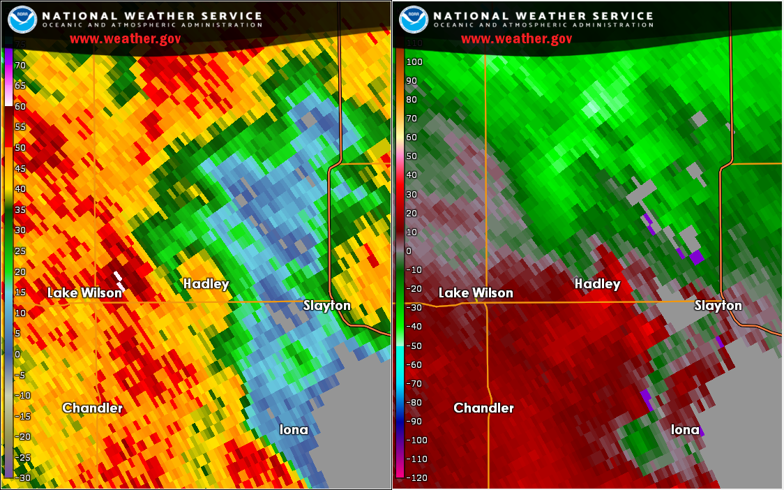
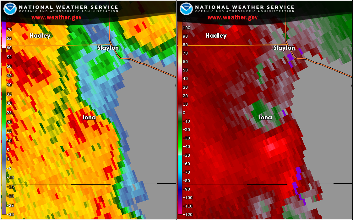
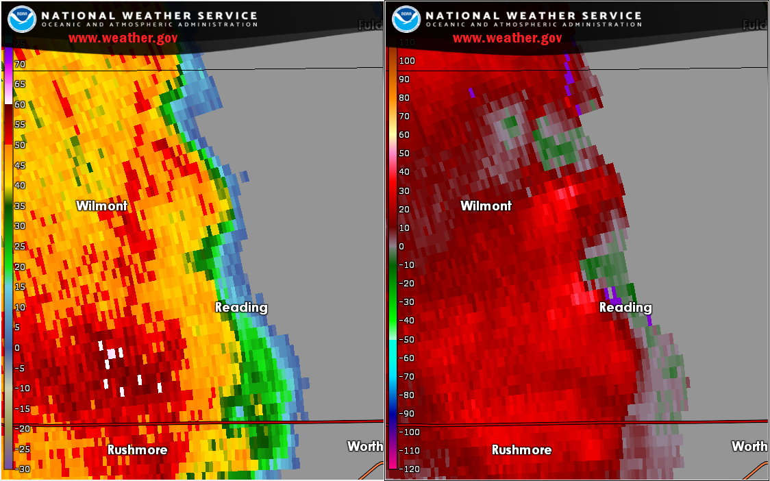
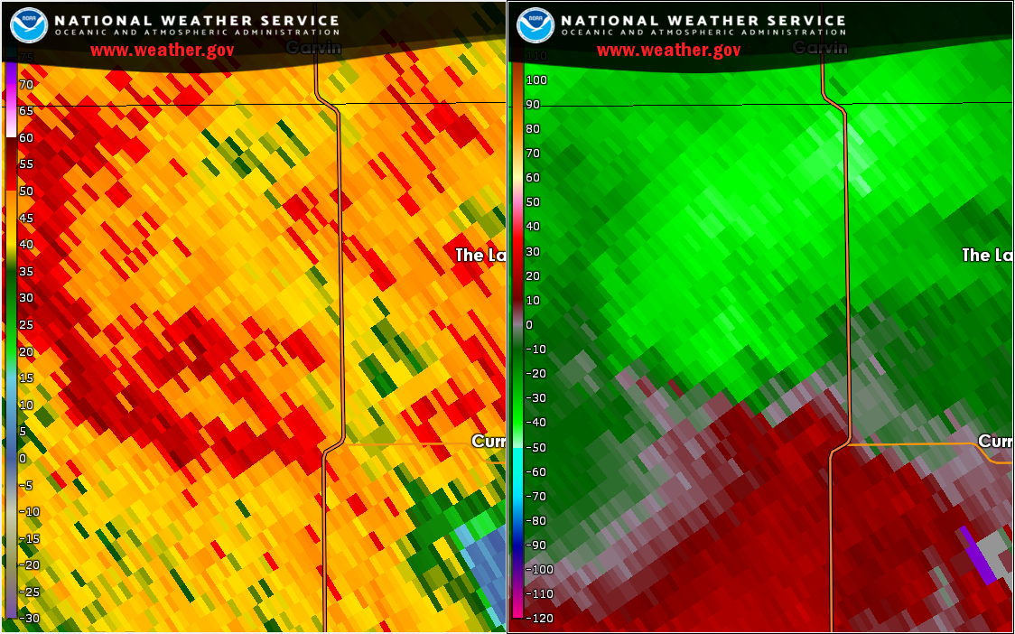
Radar
Squall line and tornadoes from August 17, 2019
 |
 |
 |
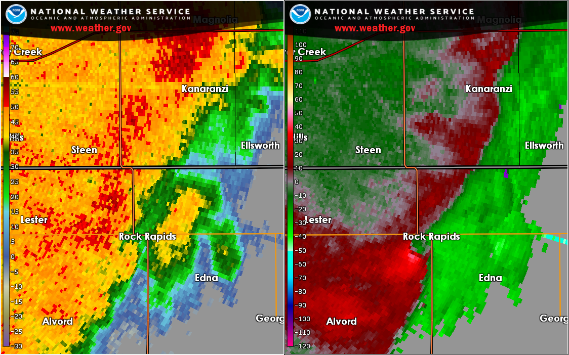 |
| Loop of Radar Reflectivity | Loop of Radar Velocity | Radar Image as Tornado was south of Hadley, Minnesota at 10:57 PM CDT |
Radar Image as Tornado was south of Rock Rapids, Iowa at 10:39 PM CDT |
 |
 |
 |
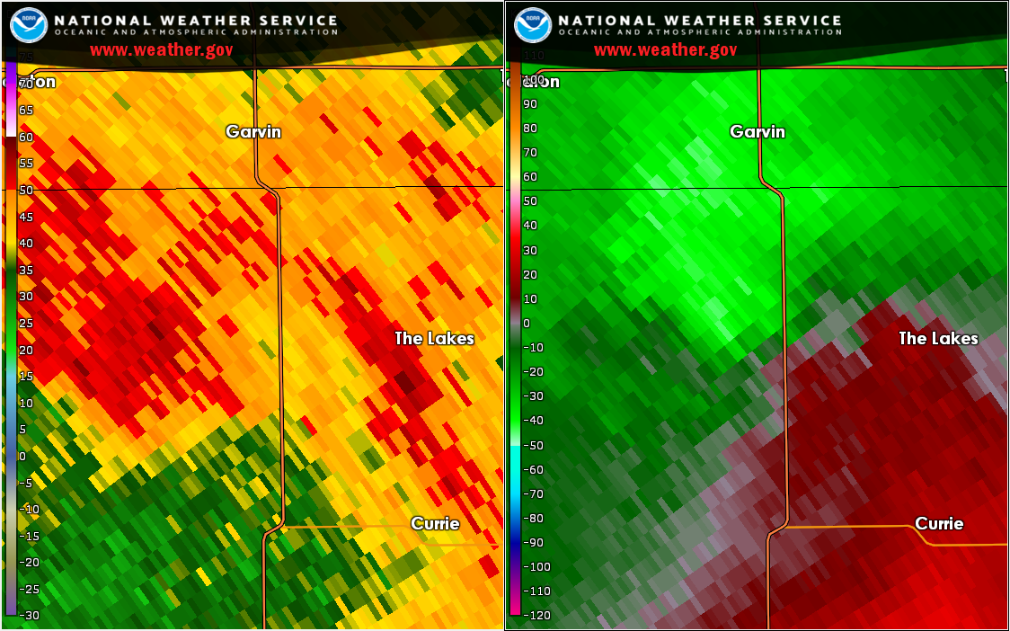 |
| Radar Image as the tornado was south of Iona, Minnesota at 10:59 PM CDT |
Radar Image as the tornado was northwest of Reading, Minnesota at 10:59 PM CDT |
Radar Image as the tornado was in rural Murray County west of Lake Shetek at 11:06 PM CDT | Radar Image as the tornado was south of Lake Sarah at 11:14 PM CDT |
 |
|||
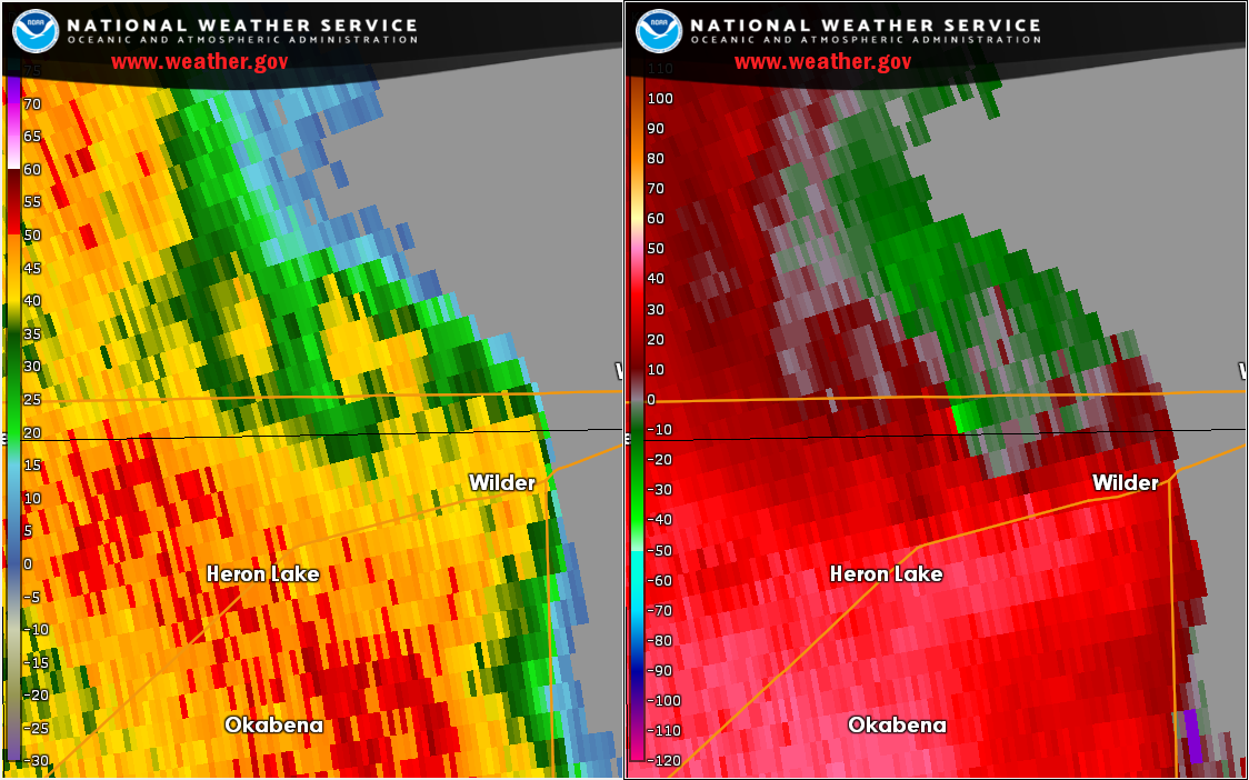
| Radar Image as the tornado was in rural Cottonwood County west of Windom at 11:25 PM CDT |
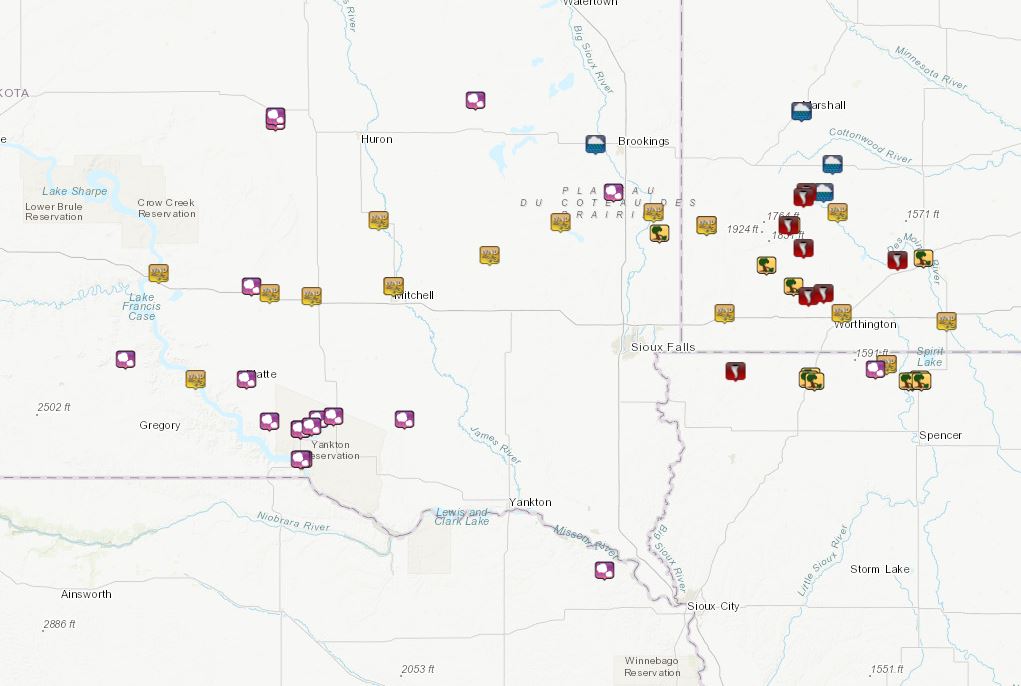
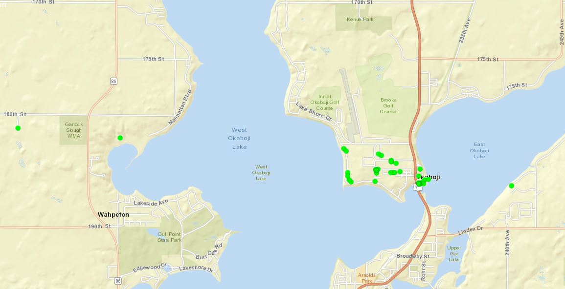
Storm Reports & Rainfall
 |
 |
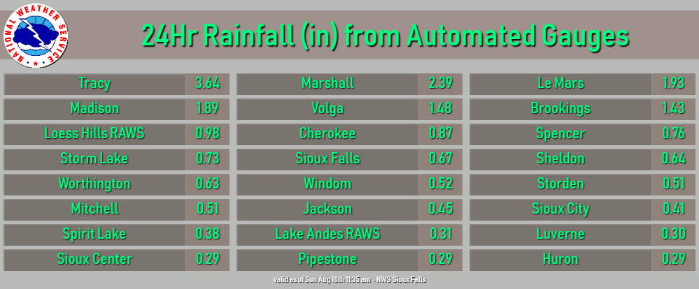 |
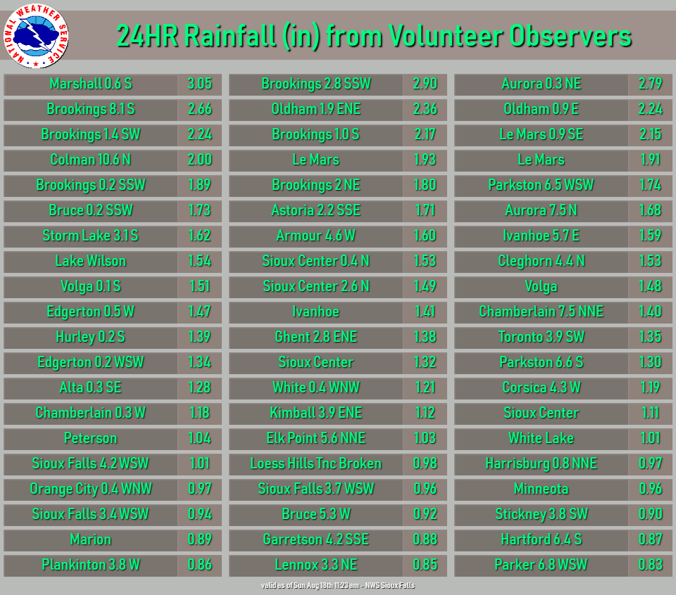
| Map showing the locations where damage to trees, homes and businesses were reported around Lake Okoboji. | Rainfall reports from volunteer observers | Rainfall reports from automated gauges |
| Local Storm Reports (timestamps are UTC) | ||||||
| Report Time | County | Location | ST | Event Type | Mag. | Remark |
| Sat Aug 17 2019 23:10:00 | Charles Mix | 2 SSW Geddes | SD | HAIL | 1.75 | lots of rain, and hail occurred for 40 minutes. |
| Sat Aug 17 2019 23:28:00 | Charles Mix | Pickstown | SD | HAIL | 0.7 | |
| Sat Aug 17 2019 23:30:00 | Charles Mix | Pickstown | SD | HAIL | 1.5 | picture received via social media. |
| Sun Aug 18 2019 00:14:00 | Gregory | 6 NNW Dixon | SD | HAIL | 1.5 | |
| Sun Aug 18 2019 00:16:00 | Charles Mix | 2 N Lake Andes | SD | HAIL | 0.88 | |
| Sun Aug 18 2019 00:17:00 | Beadle | 2 SSE Wessington | SD | HAIL | 0.88 | dime to nickel sized hail with heavy rain. |
| Sun Aug 18 2019 00:19:00 | Beadle | 3 SSE Wessington | SD | HAIL | 1.25 | car dented due to the hail. |
| Sun Aug 18 2019 00:30:00 | Charles Mix | 2 N Lake Andes | SD | HAIL | 2 | |
| Sun Aug 18 2019 00:35:00 | Brule | Chamberlain | SD | TSTM WND GST | 56 | |
| Sun Aug 18 2019 00:46:00 | Aurora | White Lake | SD | TSTM WND GST | 61 | sdsu station. |
| Sun Aug 18 2019 00:47:00 | Brule | 5 WNW White Lake | SD | HAIL | 1.75 | |
| Sun Aug 18 2019 00:50:00 | Charles Mix | 14 W Platte | SD | TSTM WND GST | 51 | rwis station. |
| Sun Aug 18 2019 00:52:00 | Charles Mix | 4 ENE Lake Andes | SD | HAIL | 1.25 | report via social media. |
| Sun Aug 18 2019 00:53:00 | Charles Mix | 6 N Ravinia | SD | HAIL | 1.5 | |
| Sun Aug 18 2019 00:55:00 | Charles Mix | 6 S Armour | SD | HAIL | 1.25 | report via mping. |
| Sun Aug 18 2019 01:10:00 | Aurora | Plankinton | SD | TSTM WND GST | 65 | rwis station. |
| Sun Aug 18 2019 01:35:00 | Davison | 2 N Mitchell | SD | TSTM WND GST | 53 | |
| Sun Aug 18 2019 01:38:00 | Charles Mix | Platte | SD | HAIL | 1.25 | report via social media. |
| Sun Aug 18 2019 01:40:00 | Sanborn | Forestburg | SD | TSTM WND GST | 55 | rwis station. |
| Sun Aug 18 2019 01:45:00 | Davison | 2 N Mitchell | SD | TSTM WND GST | 61 | |
| Sun Aug 18 2019 02:02:00 | Kingsbury | 7 W Erwin | SD | HAIL | 0.75 | |
| Sun Aug 18 2019 02:25:00 | Miner | Canova | SD | TSTM WND GST | 58 | cwop station. |
| Sun Aug 18 2019 02:48:00 | Moody | 10 N Colman | SD | HAIL | 0.5 | |
| Sun Aug 18 2019 02:53:00 | Lake | Madison | SD | TSTM WND GST | 59 | |
| Sun Aug 18 2019 03:10:00 | Moody | 5 ESE Egan | SD | TSTM WND DMG | severe damage to farm outbuilding. winds estimated 75 mph. | |
| Sun Aug 18 2019 03:12:00 | Moody | Flandreau | SD | TSTM WND GST | 54 | sdsu station. |
| Sun Aug 18 2019 03:16:00 | Hutchinson | Tripp | SD | HAIL | 1 | mping station. |
| Sun Aug 18 2019 03:27:00 | Pipestone | Pipestone | MN | TSTM WND GST | 60 | some power outages reported around town. |
| Sun Aug 18 2019 03:32:00 | Pipestone | Pipestone | MN | TSTM WND GST | 60 | some power outages reported around town. |
| Sun Aug 18 2019 03:35:00 | Rock | Luverne | MN | TSTM WND GST | 54 | |
| Sun Aug 18 2019 03:35:00 | Brookings | Volga | SD | HEAVY RAIN | 1.31 | rain fell in approx 45 minutes. |
| Sun Aug 18 2019 03:41:00 | Lyon | 1 SE Rock Rapids | IA | TORNADO | time estimated based on radar. additional detail from storm survey will be complied monday, 8-19-2019. | |
| Sun Aug 18 2019 03:48:00 | Nobles | 6 NNW Lismore | MN | TSTM WND DMG | garage blown off of foundation. numerous large tree limbs down. | |
| Sun Aug 18 2019 03:53:00 | Nobles | Wilmont | MN | TSTM WND DMG | power lines down in wilmont. picture via social media. | |
| Sun Aug 18 2019 03:56:00 | Murray | Hadley | MN | TSTM WND DMG | structural damage to a pair of garages in town. one garage blown off its foundation with cinder blocks from foundation rolled northeast. additional damage to trees in the city. | |
| Sun Aug 18 2019 03:57:00 | Murray | Hadley | MN | TORNADO | time estimated based on radar. additional detail from storm survey will be compiled monday, 8-19-2019. | |
| Sun Aug 18 2019 03:59:00 | Nobles | 5 SE Wilmont | MN | TORNADO | start of damage path. trees uprooted with several large branches down. | |
| Sun Aug 18 2019 03:59:00 | Murray | 1 S Iona | MN | TORNADO | start of damage path. corn flattened. | |
| Sun Aug 18 2019 04:01:00 | Osceola | Sibley | IA | TSTM WND DMG | damage to metal shed and many trees down. report via social media. | |
| Sun Aug 18 2019 04:01:00 | Osceola | 1 SSW Sibley | IA | TSTM WND DMG | several grain bins damaged. road signs bent over on the south exit to sibley from highway 60. | |
| Sun Aug 18 2019 04:02:00 | Osceola | 2 SE Sibley | IA | TSTM WND DMG | damage to grain bins. bolts holding empty bin in place broken with bin lifted/shifted from original position. top collapsed in on northwest side. wind estimated 85 mph. | |
| Sun Aug 18 2019 04:03:00 | Nobles | 8 NNW Worthington | MN | TORNADO | end of 4 mile damage path. | |
| Sun Aug 18 2019 04:07:00 | Nobles | 2 NE Worthington | MN | TSTM WND GST | 56 | |
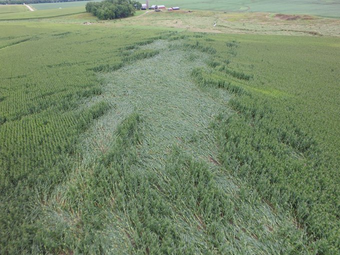
| Sun Aug 18 2019 04:08:00 | Murray | 6 WNW Currie | MN | TORNADO | start of nearly mile long damage path. over the path, corn was flattened, several trees damaged and an old barn destroyed. | |
| Sun Aug 18 2019 04:14:00 | Murray | 6 S Garvin | MN | TORNADO | start of slightly over one mile long damage path. during the two-minute tornado, some damage was done to farm outbuildings and corn was flattened. | |
| Sun Aug 18 2019 04:24:00 | Lyon | Marshall | MN | HEAVY RAIN | 1.37 | 1 hour rainfall total. |
| Sun Aug 18 2019 04:24:00 | Dickinson | 3 ESE Harris | IA | HAIL | 0.88 | |
| Sun Aug 18 2019 04:25:00 | Dickinson | 3 SSE Lake Park | IA | TSTM WND GST | 54 | |
| Sun Aug 18 2019 04:25:00 | Dickinson | Lake Park | IA | TSTM WND GST | 54 | |
| Sun Aug 18 2019 04:25:00 | Cottonwood | 4 NW Wilder | MN | TORNADO | start of 1/2 mile path. corn flattened and shredded. max path width of 20 yards. | |
| Sun Aug 18 2019 04:30:00 | Dickinson | 1 WNW Wahpeton | IA | TSTM WND DMG | roof damage to a small barn. wind estimated 75 mph. | |
| Sun Aug 18 2019 04:32:00 | Dickinson | 1 NNW Wahpeton | IA | TSTM WND DMG | large branches down, up to 3 inches in diameter. | |
| Sun Aug 18 2019 04:35:00 | Jackson | Jackson | MN | TSTM WND GST | 56 | |
| Sun Aug 18 2019 04:35:00 | Dickinson | 1 SSE Okoboji | IA | TSTM WND DMG | trees uprooted. wind estimated 90 mph. | |
| Sun Aug 18 2019 04:36:00 | Murray | 4 N Currie | MN | HEAVY RAIN | 1.46 | 1 hour rainfall total. |
| Sun Aug 18 2019 04:40:00 | Dickinson | Okoboji | IA | TSTM WND DMG | 2 large tree branches down blocking lakeshore drive. | |
| Sun Aug 18 2019 04:45:00 | Cottonwood | Windom | MN | TSTM WND DMG | tree branches down blocking the road at 12th street and miller ave on the east side of town. | |
| Sun Aug 18 2019 04:50:00 | Murray | 2 W Dovray | MN | TSTM WND GST | 59 | rwis station. |
| Sun Aug 18 2019 04:55:00 | Lyon | Marshall | MN | HEAVY RAIN | 2.23 | 1.5 hour rainfall total. |
| Sun Aug 18 2019 05:55:00 | Dixon | 2 S Newcastle | NE | HAIL | 0.88 | |
| Sun Aug 18 2019 06:00:00 | Lyon | Tracy | MN | HEAVY RAIN | 3.56 | |
 |
Media use of NWS Web News Stories is encouraged! Please acknowledge the NWS as the source of any news information accessed from this site. |
|


 Weather Story
 Weather Map
 Local Radar