Overview
|
A fast-moving winter storm moved through the Central U.S. on Tuesday November 10, 2020. A round of freezing rain and sleet transitioned to snow gradually over the day, bringing widespread snow to South Dakota, Minnesota, Iowa, and Nebraska. Prolonged freezing rain brought up to 0.50-inch ice accumulations and tree damage to northwest Iowa as well. By the evening of November 10th, heavy snow across far southeast SD and far southwest MN caused widespread travel impacts in the region. Travel impacts lingered well into November 11th, Veterans Day. |
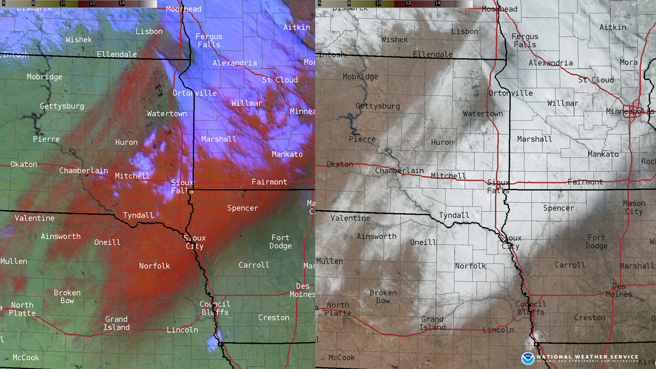 GOES-16 captures snow cover from the November 10, 2020 winter storm |
Snow/Ice
Freezing rain occurred across much of northwest Iowa, especially Dakota, Buena Vista, Cherokee, Ida, and Woodbury counties through mid afternoon on November 10th. Ice accumulations were reported up to 1/2 inch with ice accumulating on trees, power lines, and other elevated surfaces. A few icy roads were reported, but the ground remained fairly warm, so the main impacts were tree damage and occasional power outages.
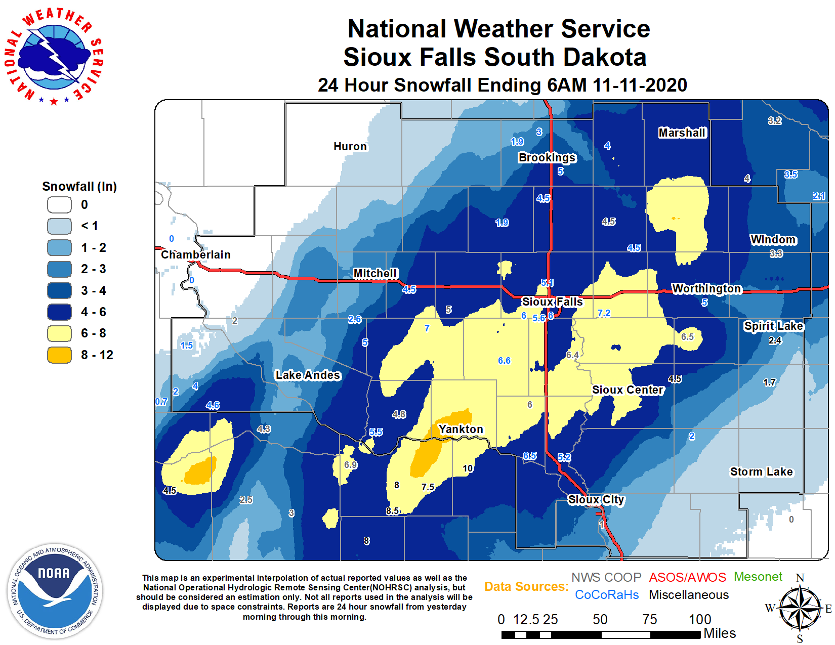
Across the remainder of the region, freezing rain transitioned to sleet and snow in the morning hours. Snow totals of 3-7 inches were common, but portions of central SD and west central IA received very little (if any snow).
Photos & Video
Snow and Ice Impacts
 |
 |
 |
 |
| Heavy Snow in Yankton, SD (Tamara Pease) |
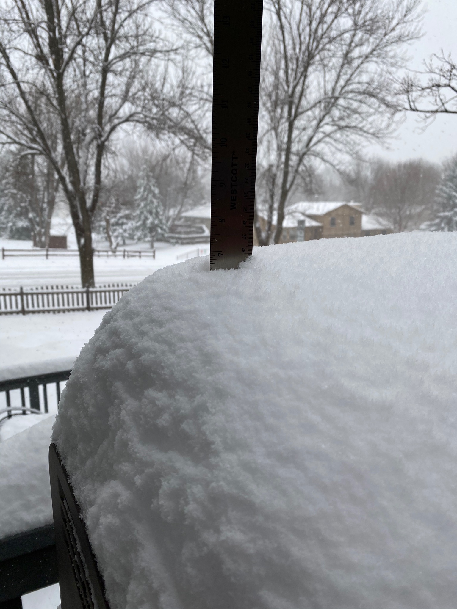
Backyard view of heavy snow, western Sioux Falls (Twitter: @bibliofiddler) |
Tree damage from heavy icing in Fonda, IA (City of Fonda) |
Ice coated trees in Fonda, IA (City of Fonda) |
 |
 |
.jpg) |
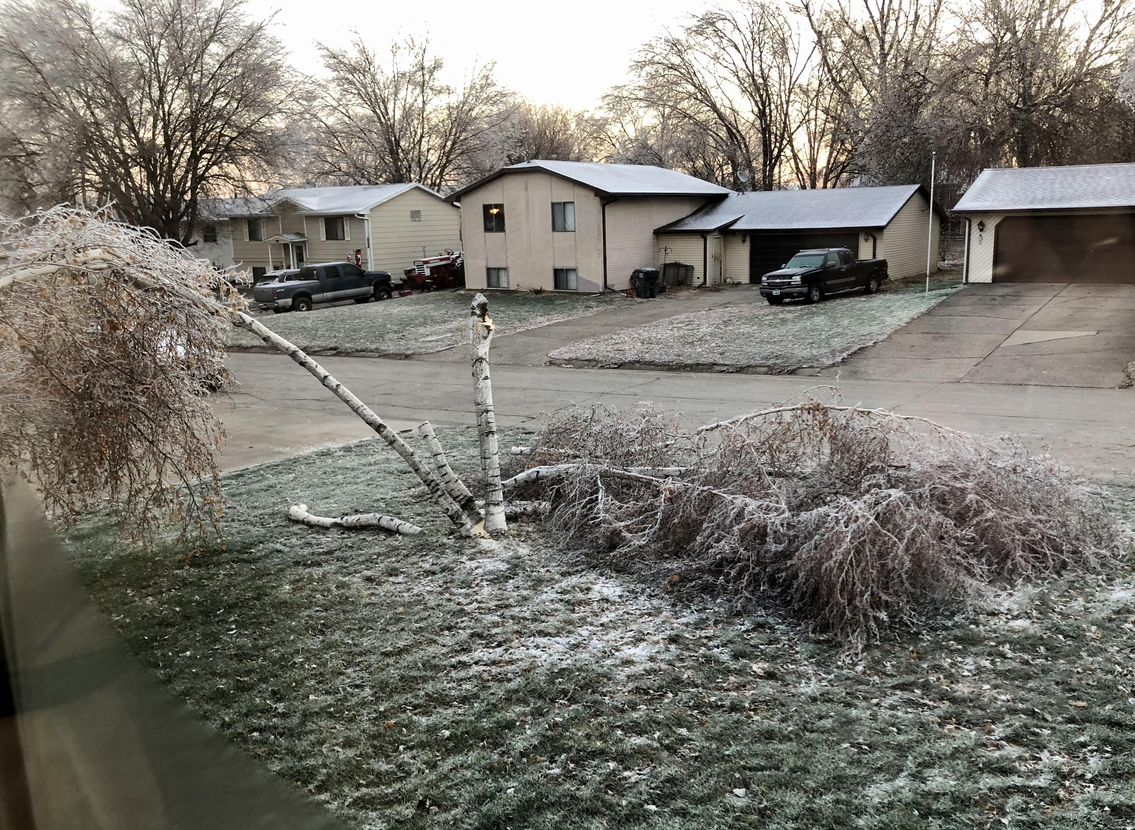 |
| Tree limbs on power lines, Fonda, IA (City of Fonda) |
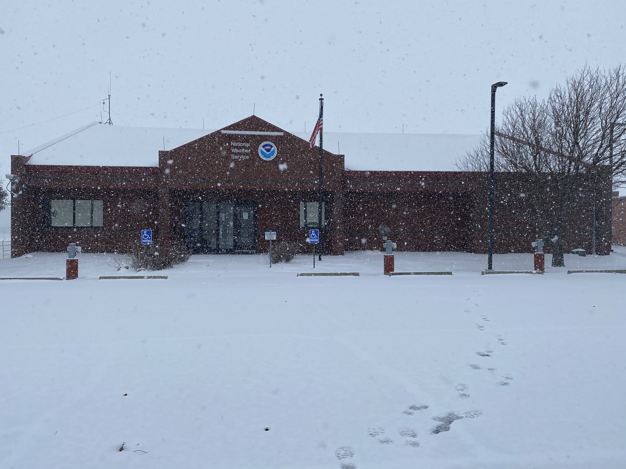
Heavy Snow at NWS Sioux Falls (NWS Sioux Falls) |
Playing in the Snow, Sioux Falls (Sheela Riley) |
Light snow and tree damage from ice, Ida Grove, IA (Stephanie Konradi) |
 |
 |
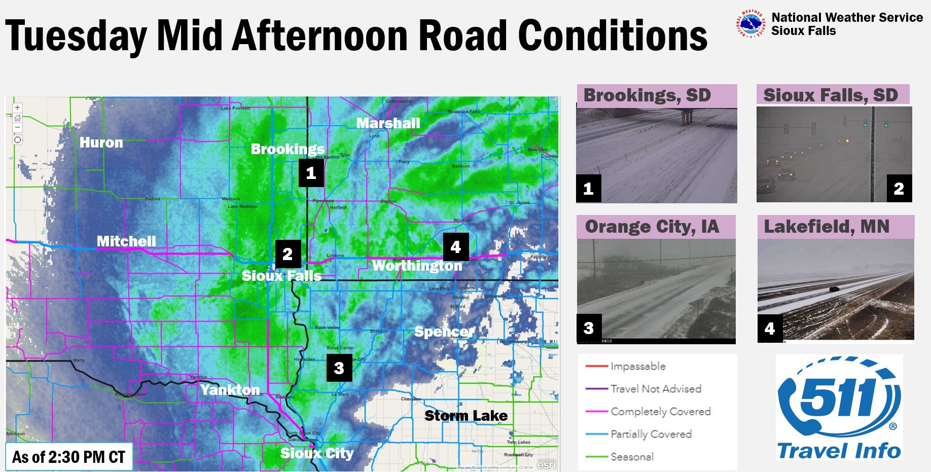
| Road Conditions and Webcams Tuesday Afternoon (SD, IA, NE, and MN DOTs) |
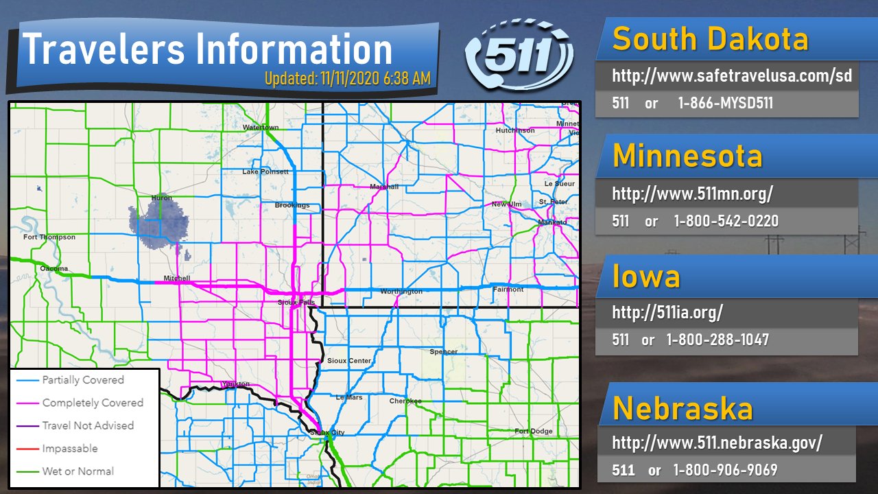
Road Conditions Wednesday Morning (SD, IA, NE, and MN DOTs) |
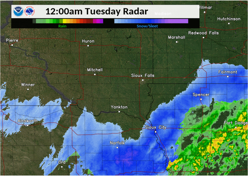
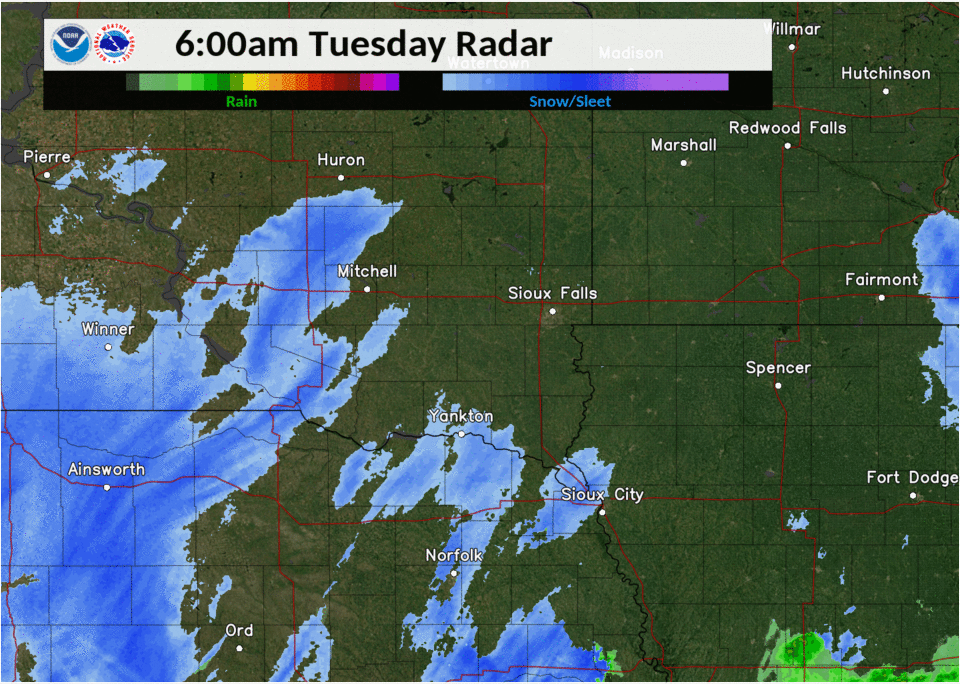
Radar
.gif) |
 |
 |
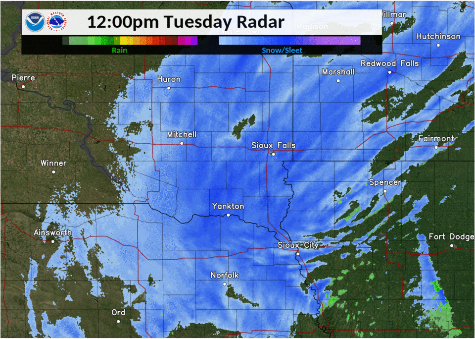 |
| Freezing Rain and Sleet Monday Evening 6 PM 11/9/20 - 12 AM 11/10/2020 |
Wintry Mix Late Monday Night 12 AM - 6 AM 11/10/2020 |
Wintry Mix and Snow Tuesday 6 AM - 12 PM 11/10/2020 |
Wintry Mix and Heavy Snow Tuesday Afternoon 12 PM - 6 PM 11/10/2020 |
Snow Reports
PRELIMINARY LOCAL STORM REPORT...SUMMARY
NATIONAL WEATHER SERVICE SIOUX FALLS SD
1056 AM CST WED NOV 11 2020

..TIME...   ...EVENT...      ...CITY LOCATION...     ...LAT.LON...
..DATE...   ....MAG....      ..COUNTY LOCATION..ST.. ...SOURCE....
            ..REMARKS..

0400 PM     SNOW             4 WSW SIOUX FALLS       43.52N 96.80W
11/10/2020  M7.0 INCH        MINNEHAHA          SD   PUBLIC

            REPORTED AT KUEHN PARK. REPORT VIA SOCIAL
            MEDIA.

0322 PM     SNOW             PARKER                  43.40N 97.14W
11/10/2020  E7.0 INCH        TURNER             SD   PUBLIC

            REPORT VIA SOCIAL MEDIA.

0700 AM     HEAVY SNOW       1 SE VERMILLION         42.77N 96.91W
11/11/2020  M6.5 INCH        CLAY               SD   COCORAHS

0700 AM     HEAVY SNOW       SIBLEY                  43.40N 95.74W
11/11/2020  M6.5 INCH        OSCEOLA            IA   CO-OP OBSERVER

0700 AM     HEAVY SNOW       4 SSE GARRETSON         43.66N 96.47W
11/11/2020  M6.5 INCH        MINNEHAHA          SD   COCORAHS

0315 PM     SNOW             1 SE TEA                43.44N 96.82W
11/10/2020  M6.5 INCH        LINCOLN            SD   TRAINED SPOTTER

            UPDATES PREVIOUS SNOW REPORT FROM 1 SE TEA.
            REPORT VIA SOCIAL MEDIA.

0700 AM     HEAVY SNOW       CANTON                  43.30N 96.58W
11/11/2020  M6.4 INCH        LINCOLN            SD   CO-OP OBSERVER

0630 PM     SNOW             1 W VERMILLION          42.78N 96.95W
11/10/2020  M6.3 INCH        CLAY               SD   PUBLIC

            REPORT VIA SOCIAL MEDIA.

0600 PM     SNOW             2 W SIOUX FALLS         43.54N 96.77W
11/10/2020  M6.1 INCH        MINNEHAHA          SD   NWS EMPLOYEE

0700 AM     HEAVY SNOW       5 WSW BERESFORD         43.06N 96.87W
11/11/2020  M6.0 INCH        CLAY               SD   CO-OP OBSERVER

0850 PM     SNOW             4 NNE TEA               43.50N 96.79W
11/10/2020  M6.0 INCH        LINCOLN            SD   PUBLIC

            REPORT VIA SOCIAL MEDIA.

0721 PM     SNOW             SCOTLAND                43.15N 97.72W
11/10/2020  E6.0 INCH        BON HOMME          SD   PUBLIC

            REPORT VIA SOCIAL MEDIA.

0636 PM     SNOW             1 W YANKTON             42.89N 97.41W
11/10/2020  M6.0 INCH        YANKTON            SD   PUBLIC

            REPORT VIA SOCIAL MEDIA.

0600 PM     SNOW             MENNO                   43.24N 97.57W
11/10/2020  M6.0 INCH        HUTCHINSON         SD   CO-OP OBSERVER

            CO-OP OBSERVER STATION MNOS2 MENNO.

0510 PM     SNOW             5 N TEA                 43.51N 96.83W
11/10/2020  M6.0 INCH        MINNEHAHA          SD   PUBLIC

            REPORT VIA SOCIAL MEDIA.

0500 PM     SNOW             2 E CONCORD             42.38N 96.96W
11/10/2020  M6.0 INCH        DIXON              NE   CO-OP OBSERVER

            CO-OP OBSERVER STATION NESN1 CONCORD.

0500 PM     SNOW             BROOKINGS               44.31N 96.79W
11/10/2020  E6.0 INCH        BROOKINGS          SD   PUBLIC

            REPORT VIA SOCIAL MEDIA.

0400 PM     SNOW             2 WSW GARRETSON         43.71N 96.53W
11/10/2020  M6.0 INCH        MINNEHAHA          SD   COCORAHS

            COCORAHS STATION SD-MH-91 GARRETSON 1.7 WSW.

0312 PM     SNOW             COLTON                  43.79N 96.93W
11/10/2020  E6.0 INCH        MINNEHAHA          SD   PUBLIC

            REPORT VIA SOCIAL MEDIA.

0700 AM     SNOW             3 ESE SIOUX FALLS       43.53N 96.67W
11/11/2020  M5.7 INCH        MINNEHAHA          SD   NWS EMPLOYEE

0800 AM     SNOW             2 NE BROOKINGS          44.33N 96.76W
11/11/2020  M5.6 INCH        BROOKINGS          SD   CO-OP OBSERVER

1007 PM     SNOW             2 NW PONCA              42.59N 96.75W
11/10/2020  M5.6 INCH        DIXON              NE   COCORAHS

            COCORAHS STATION NE-DX-1 PONCA 2.5 NW.

0700 AM     SNOW             6 NW MONTROSE           43.76N 97.27W
11/11/2020  M5.5 INCH        MCCOOK             SD   COCORAHS

0600 AM     SNOW             NEWCASTLE               42.65N 96.87W
11/11/2020  M5.5 INCH        DIXON              NE   CO-OP OBSERVER

0932 PM     SNOW             GHENT                   44.51N 95.89W
11/10/2020  M5.5 INCH        LYON               MN   PUBLIC

0820 PM     SNOW             YANKTON                 42.89N 97.39W
11/10/2020  M5.5 INCH        YANKTON            SD   PUBLIC

            REPORT VIA SOCIAL MEDIA.

0600 PM     SNOW             3 N SIOUX FALLS         43.59N 96.73W
11/10/2020  E5.5 INCH        MINNEHAHA          SD   OFFICIAL NWS OBS

            STORM TOTAL SNOWFALL.

0530 PM     SNOW             1 NNE HARRISBURG        43.44N 96.69W
11/10/2020  M5.5 INCH        LINCOLN            SD   NWS EMPLOYEE

0700 AM     SNOW             2 N CHESTER             43.92N 96.93W
11/11/2020  M5.4 INCH        LAKE               SD   CO-OP OBSERVER

0300 PM     SNOW             1 SSE VERMILLION        42.76N 96.92W
11/10/2020  M5.3 INCH        CLAY               SD   CO-OP OBSERVER

            CO-OP OBSERVER STATION VRMS2 1.4 S
            VERMILLION.

0700 AM     SNOW             6 NNE ELK POINT         42.76N 96.64W
11/11/2020  M5.2 INCH        UNION              SD   COCORAHS

0800 AM     SNOW             PIPESTONE               44.00N 96.31W
11/11/2020  M5.0 INCH        PIPESTONE          MN   PUBLIC

0800 AM     SNOW             MARSHALL                44.45N 95.79W
11/11/2020  M5.0 INCH        LYON               MN   CO-OP OBSERVER

0800 AM     SNOW             BRIDGEWATER             43.55N 97.50W
11/11/2020  M5.0 INCH        MCCOOK             SD   CO-OP OBSERVER

0700 AM     SNOW             7 NNE DELMONT           43.35N 98.11W
11/11/2020  M5.0 INCH        DOUGLAS            SD   COCORAHS

0700 AM     SNOW             TRACY                   44.24N 95.62W
11/11/2020  M5.0 INCH        LYON               MN   CO-OP OBSERVER

0700 AM     SNOW             LAKE WILSON             43.99N 95.95W
11/11/2020  M5.0 INCH        MURRAY             MN   CO-OP OBSERVER

0845 PM     SNOW             WENTWORTH               44.00N 96.96W
11/10/2020  M5.0 INCH        LAKE               SD   PUBLIC

            REPORT VIA SOCIAL MEDIA.

0715 PM     SNOW             4 NNE TEA               43.51N 96.81W
11/10/2020  M5.0 INCH        MINNEHAHA          SD   PUBLIC

            REPORT VIA SOCIAL MEDIA.

0630 PM     SNOW             3 NE CROOKS             43.69N 96.76W
11/10/2020  M5.0 INCH        MINNEHAHA          SD   PUBLIC

            REPORT VIA SOCIAL MEDIA.

0600 PM     SNOW             GARRETSON               43.72N 96.50W
11/10/2020  M5.0 INCH        MINNEHAHA          SD   PUBLIC

            REPORT VIA SOCIAL MEDIA.

0521 PM     SNOW             VOLGA                   44.32N 96.92W
11/10/2020  M5.0 INCH        BROOKINGS          SD   COCORAHS

            COCORAHS STATION SD-BK-48 VOLGA 0.1 S.

0520 PM     SNOW             WHITE                   44.43N 96.65W
11/10/2020  M5.0 INCH        BROOKINGS          SD   PUBLIC

            REPORT VIA SOCIAL MEDIA.

0500 PM     SNOW             3 NE CROOKS             43.69N 96.78W
11/10/2020  M5.0 INCH        MINNEHAHA          SD   COCORAHS

            COCORAHS SITE SD-MH-71. STORM TOTAL THROUGH
            430 PM CST.

0453 PM     SNOW             WHITE                   44.43N 96.65W
11/10/2020  M5.0 INCH        BROOKINGS          SD   COCORAHS

            COCORAHS SITE SD-BK-17. TOTAL THROUGH 430
            CST, FELL OVER 4.5 HOURS.

0435 PM     SNOW             AKRON                   42.83N 96.56W
11/10/2020  E5.0 INCH        PLYMOUTH           IA   PUBLIC

            REPORT VIA SOCIAL MEDIA.

0430 PM     SNOW             AURORA                  44.28N 96.69W
11/10/2020  M5.0 INCH        BROOKINGS          SD   PUBLIC

            REPORT VIA SOCIAL MEDIA.

0800 AM     SNOW             TYNDALL                 42.99N 97.86W
11/11/2020  M4.8 INCH        BON HOMME          SD   CO-OP OBSERVER

0200 PM     SNOW             1 WNW VERMILLION        42.79N 96.94W
11/10/2020  E4.6 INCH        CLAY               SD   PUBLIC

            REPORT VIA SOCIAL MEDIA.

0700 AM     SNOW             10 E NUNDA              44.14N 96.82W
11/11/2020  M4.5 INCH        MOODY              SD   COCORAHS

0700 AM     SNOW             6 SSW HERRICK           43.04N 99.21W
11/11/2020  M4.5 INCH        GREGORY            SD   COCORAHS

0700 AM     SNOW             SHELDON                 43.18N 95.84W
11/11/2020  M4.5 INCH        O'BRIEN            IA   CO-OP OBSERVER

0700 AM     SNOW             ALEXANDRIA              43.65N 97.78W
11/11/2020  M4.5 INCH        HANSON             SD   COCORAHS

0600 AM     SNOW             EDGERTON                43.87N 96.13W
11/11/2020  M4.5 INCH        PIPESTONE          MN   COCORAHS

            COCORAHS STATION MN-PS-6 EDGERTON 0.2 WSW.
            STORM TOTAL SNOWFALL.

0700 PM     SNOW             6 W SINAI               44.24N 97.17W
11/10/2020  M4.5 INCH        KINGSBURY          SD   COCORAHS

            COCORAHS STATION SD-KY-10 ARLINGTON 9.0 SSW.

0549 PM     SNOW             3 SE SIOUX FALLS        43.50N 96.70W
11/10/2020  M4.5 INCH        MINNEHAHA          SD   PUBLIC

            NEAR 57TH STREET AND CLIFF AVENUE. STORM
            TOTAL SNOWFALL.

0510 PM     SNOW             4 N CURRIE              44.13N 95.68W
11/10/2020  M4.5 INCH        MURRAY             MN   COCORAHS

            COCORAHS STATION MN-MY-5 TRACY 7.8 SSW.

0700 AM     SNOW             4 SW BURKE              43.14N 99.35W
11/11/2020  M4.0 INCH        GREGORY            SD   COCORAHS

0700 AM     SNOW             ORANGE CITY             43.00N 96.06W
11/11/2020  M4.0 INCH        SIOUX              IA   CO-OP OBSERVER

700 AM     SNOW             2 SE MADISON            43.99N 97.08W
11/11/2020  M4.0 INCH        LAKE               SD   CO-OP OBSERVER

0915 PM     SNOW             3 N SIOUX CENTER        43.11N 96.18W
11/10/2020  M4.0 INCH        SIOUX              IA   PUBLIC

0520 PM     SNOW             DELL RAPIDS             43.82N 96.71W
11/10/2020  E4.0 INCH        MINNEHAHA          SD   PUBLIC

            REPORT VIA SOCIAL MEDIA.

1249 PM     SNOW             4 W IRETON              42.99N 96.40W
11/10/2020  E4.0 INCH        SIOUX              IA   PUBLIC

            REPORT VIA PHONE CALL TO OFFICE.

0700 AM     SNOW             3 NNW WAHPETON          43.42N 95.19W
11/11/2020  M3.4 INCH        DICKINSON          IA   CO-OP OBSERVER

0700 AM     SNOW             WINDOM                  43.87N 95.12W
11/11/2020  M3.3 INCH        COTTONWOOD         MN   CO-OP OBSERVER

0700 AM     SNOW             LE MARS                 42.79N 96.17W
11/11/2020  M3.0 INCH        PLYMOUTH           IA   PUBLIC

0700 AM     SNOW             2 NE WORTHINGTON        43.65N 95.57W
11/11/2020  M3.0 INCH        NOBLES             MN   CO-OP OBSERVER

0600 AM     SNOW             1 WSW SERGEANT BLUFF    42.40N 96.38W
11/11/2020  M3.0 INCH        WOODBURY           IA   CO-OP OBSERVER

            CO-OP OBSERVER STATION SXGI4 SIOUX CITY.

0800 AM     SNOW             SPIRIT LAKE             43.42N 95.11W
11/11/2020  M2.4 INCH        DICKINSON          IA   CO-OP OBSERVER

1100 PM     SNOW             1 SSW MITCHELL          43.71N 98.04W
11/10/2020  M2.2 INCH        DAVISON            SD   CO-OP OBSERVER

            CO-OP OBSERVER STATION MCLS2 MITCHELL.

0900 AM     SNOW             11 WNW PLATTE           43.45N 99.05W
11/11/2020  M2.0 INCH        CHARLES MIX        SD   CO-OP OBSERVER

0700 AM     SNOW             4 N CLEGHORN            42.87N 95.71W
11/11/2020  M2.0 INCH        CHEROKEE           IA   COCORAHS

0700 AM     SNOW             9 S DALLAS              43.11N 99.52W
11/11/2020  M2.0 INCH        GREGORY            SD   COCORAHS

0800 AM     SNOW             1 N SPENCER             43.16N 95.15W
11/11/2020  M1.7 INCH        CLAY               IA   CO-OP OBSERVER

0700 AM     SNOW             3 ESE DIXON             43.36N 99.43W
11/11/2020  M1.5 INCH        GREGORY            SD   COCORAHS
 |
Media use of NWS Web News Stories is encouraged! Please acknowledge the NWS as the source of any news information accessed from this site. |
|


 Weather Story
 Weather Map
 Local Radar