Overview
|
Snow moved into the area during the early morning hours of Tuesday December 29, 2020. Light to even moderate snow persisted through the morning and afternoon hours, before coming to an end by the evening. The snow reduced visibility less than 1/4 mile at times, and quickly accumulated during the middle of the day. Total snow accumulations ranged between 2 and 6" of snow. In Sioux Falls, the 4.6" of snow that was recorded set a new daily record. The previous record was 4.0" of snow which took place on 1907 and 1923. Unlike a winter storm that moved through the region the prior week, winds during this event were much lower. However roads were still severely impacted with reports of accidents throughout the region. |
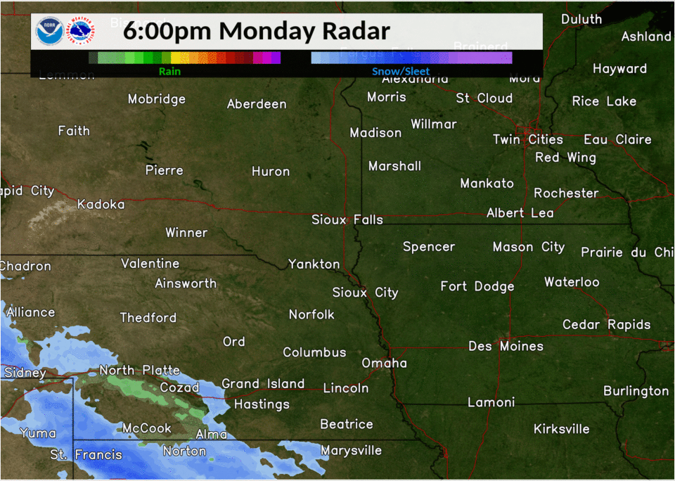 Radar Loop of Snow |
Snow/Ice
Here is a map showing observed snowfall reports across there region for this snow storm. Totals will be added through the day as reports arrive and maps are generated.
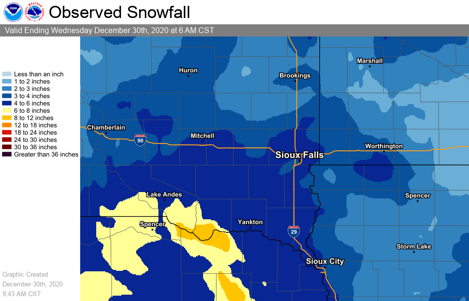 |
| Storm Total Snowfall Map |
|
PRELIMINARY LOCAL STORM REPORT...SUMMARY NATIONAL WEATHER SERVICE SIOUX FALLS SD 955 AM CST WED DEC 30 2020 ..TIME... ...EVENT... ...CITY LOCATION... ...LAT.LON... ..DATE... ....MAG.... ..COUNTY LOCATION..ST.. ...SOURCE.... ..REMARKS.. 0800 AM SNOW SIOUX RAPIDS 42.89N 95.15W 12/30/2020 M3.0 INCH BUENA VISTA IA CO-OP OBSERVER 0938 PM SNOW STORM LAKE 42.64N 95.20W 12/29/2020 E1.5 INCH BUENA VISTA IA PUBLIC REPORT VIA SOCIAL MEDIA. STORM TOTAL. 0826 AM SNOW PETERSON 42.92N 95.34W 12/30/2020 M2.9 INCH CLAY IA TRAINED SPOTTER 0715 AM SNOW 1 N ARNOLDS PARK 43.38N 95.13W 12/30/2020 E4.0 INCH DICKINSON IA PUBLIC 0800 AM SNOW 4 NW OKOBOJI 43.43N 95.18W 12/30/2020 M3.0 INCH DICKINSON IA CO-OP OBSERVER 0858 AM SNOW 4 S ARTHUR 42.28N 95.36W 12/30/2020 M3.0 INCH IDA IA PUBLIC 0800 AM SNOW SHELDON 43.18N 95.85W 12/30/2020 M2.5 INCH O'BRIEN IA CO-OP OBSERVER 0800 AM SNOW ORANGE CITY 43.00N 96.05W 12/30/2020 M2.4 INCH SIOUX IA CO-OP OBSERVER 0340 PM SNOW HULL 43.19N 96.13W 12/29/2020 E2.0 INCH SIOUX IA PUBLIC STORM TOTAL SNOWFALL, RECEIVED REPORT VIA SOCIAL MEDIA. 0600 PM SNOW SERGEANT BLUFF 42.40N 96.36W 12/29/2020 M4.0 INCH WOODBURY IA OFFICIAL NWS OBS STORM TOTAL. 0340 PM SNOW 1 N SIOUX CITY 42.52N 96.39W 12/29/2020 E3.0 INCH WOODBURY IA PUBLIC 0800 AM SNOW WINDOM 43.87N 95.12W 12/30/2020 M1.1 INCH COTTONWOOD MN CO-OP OBSERVER 0630 PM SNOW MINNEOTA 44.56N 95.98W 12/29/2020 M3.6 INCH LYON MN PUBLIC STORM TOTAL SNOW. 0639 PM SNOW GHENT 44.51N 95.89W 12/29/2020 M2.8 INCH LYON MN PUBLIC 0800 AM SNOW 2 NE WORTHINGTON 43.64N 95.58W 12/30/2020 M4.0 INCH NOBLES MN CO-OP OBSERVER 0843 PM SNOW EDGERTON 43.88N 96.13W 12/29/2020 M3.0 INCH PIPESTONE MN PUBLIC STORM TOTAL SNOW. 0653 AM SNOW 4 E HARDWICK 43.79N 96.13W 12/30/2020 M3.3 INCH ROCK MN PUBLIC STORM TOTAL. 0345 PM SNOW EMERSON 42.28N 96.73W 12/29/2020 E6.3 INCH DIXON NE PUBLIC VIA SOCIAL MEDIA REPORT. 0500 PM SNOW 2 E CONCORD 42.38N 96.96W 12/29/2020 M5.6 INCH DIXON NE CO-OP OBSERVER STORM TOTAL. CO-OP OBSERVER STATION NESN1 CONCORD. 0600 PM SNOW 2 S HURON 44.34N 98.22W 12/29/2020 M3.0 INCH BEADLE SD OFFICIAL NWS OBS SNOWFALL THRU 6PM. 0505 PM HEAVY SNOW TYNDALL 42.99N 97.87W 12/29/2020 M6.0 INCH BON HOMME SD CO-OP OBSERVER STORM TOTAL SNOWFALL. 0940 PM SNOW VERMILLION 42.78N 96.93W 12/29/2020 E5.5 INCH CLAY SD PUBLIC STORM TOTAL REPORT VIA SOCIAL MEDIA. 0750 PM HEAVY SNOW 1 SE MITCHELL 43.72N 98.01W 12/29/2020 E6.0 INCH DAVISON SD PUBLIC REPORT VIA SOCIAL MEDIA. 0600 AM SNOW 1 W ALEXANDRIA 43.65N 97.80W 12/30/2020 M4.8 INCH HANSON SD CO-OP OBSERVER STORM TOTAL. CO-OP OBSERVER STATION ALXI4 ALEXANDRIA. 0600 PM SNOW MENNO 43.24N 97.57W 12/29/2020 M5.5 INCH HUTCHINSON SD CO-OP OBSERVER STORM TOTAL. CO-OP OBSERVER STATION MNOS2 MENNO. 0800 AM SNOW 2 N CHESTER 43.93N 96.93W 12/30/2020 M3.6 INCH LAKE SD CO-OP OBSERVER 0624 PM SNOW MADISON 44.01N 97.10W 12/29/2020 E2.5 INCH LAKE SD PUBLIC REPORT VIA SOCIAL MEDIA. 0800 AM SNOW 1 NNW CANTON 43.31N 96.59W 12/30/2020 M4.0 INCH LINCOLN SD CO-OP OBSERVER 0400 PM SNOW 1 NNE HARRISBURG 43.44N 96.69W 12/29/2020 M3.9 INCH LINCOLN SD NWS EMPLOYEE STORM TOTAL. 0800 AM SNOW MONTROSE 43.70N 97.19W 12/30/2020 M2.3 INCH MCCOOK SD CO-OP OBSERVER 0315 PM SNOW HOWARD 44.01N 97.52W 12/29/2020 M4.3 INCH MINER SD PUBLIC STORM TOTAL SNOWFALL. 1200 AM SNOW 3 N SIOUX FALLS 43.59N 96.73W 12/30/2020 M4.6 INCH MINNEHAHA SD OFFICIAL NWS OBS STORM TOTAL FROM NWS OFFICE. 0649 PM SNOW 4 NNE TEA 43.51N 96.81W 12/29/2020 E4.3 INCH MINNEHAHA SD PUBLIC REPORT VIA SOCIAL MEDIA. 0452 AM SNOW 4 W ROWENA 43.55N 96.63W 12/30/2020 M3.8 INCH MINNEHAHA SD PUBLIC 0500 PM SNOW 10 NNE FORESTBURG 44.16N 98.06W 12/29/2020 M3.0 INCH SANBORN SD CO-OP OBSERVER STORM TOTAL. CO-OP OBSERVER STATION WSKS2 WOONSOCKET 13 NE. 0600 AM SNOW HURLEY 43.28N 97.09W 12/30/2020 M4.5 INCH TURNER SD COCORAHS STORM TOTAL. COCORAHS STATION SD-TR-9 HURLEY 0.2 S. 0300 PM SNOW PARKER 43.40N 97.14W 12/29/2020 M3.8 INCH TURNER SD PUBLIC STORM TOTAL SNOWFALL, RECEIVED REPORT VIA SOCIAL MEDIA. 0400 AM SNOW 1 SE NORTH SIOUX CITY 42.53N 96.49W 12/30/2020 M4.5 INCH UNION SD BROADCAST MEDIA STORM TOTAL. 0415 PM SNOW 1 WSW YANKTON 42.89N 97.40W 12/29/2020 E6.0 INCH YANKTON SD PUBLIC VIA SOCIAL MEDIA REPORT. |
Photos & Video
Photos of Snow
 |
 |
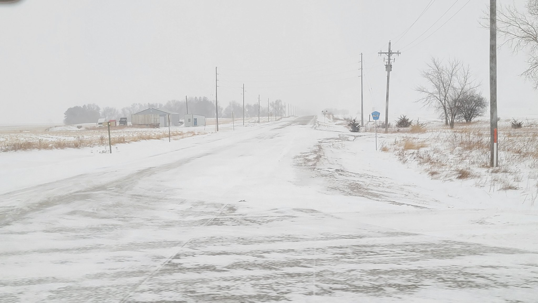 |
| Concord, NE (Joe Reklaitis) |
Tea, SD (Elizabeth Carrell) |
Fonda, IA (Alex Orion Leu) |
 |
Media use of NWS Web News Stories is encouraged! Please acknowledge the NWS as the source of any news information accessed from this site. |
|


 Weather Story
 Weather Map
 Local Radar