Overview
|
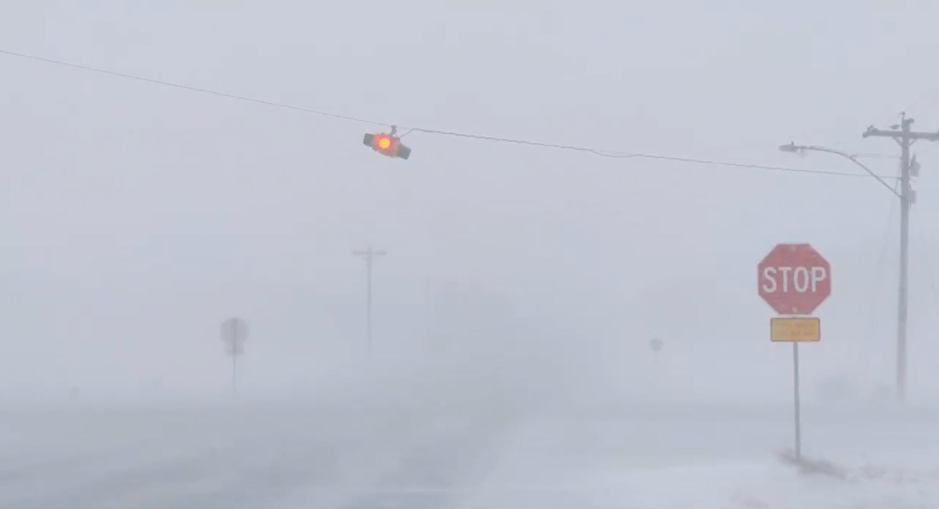
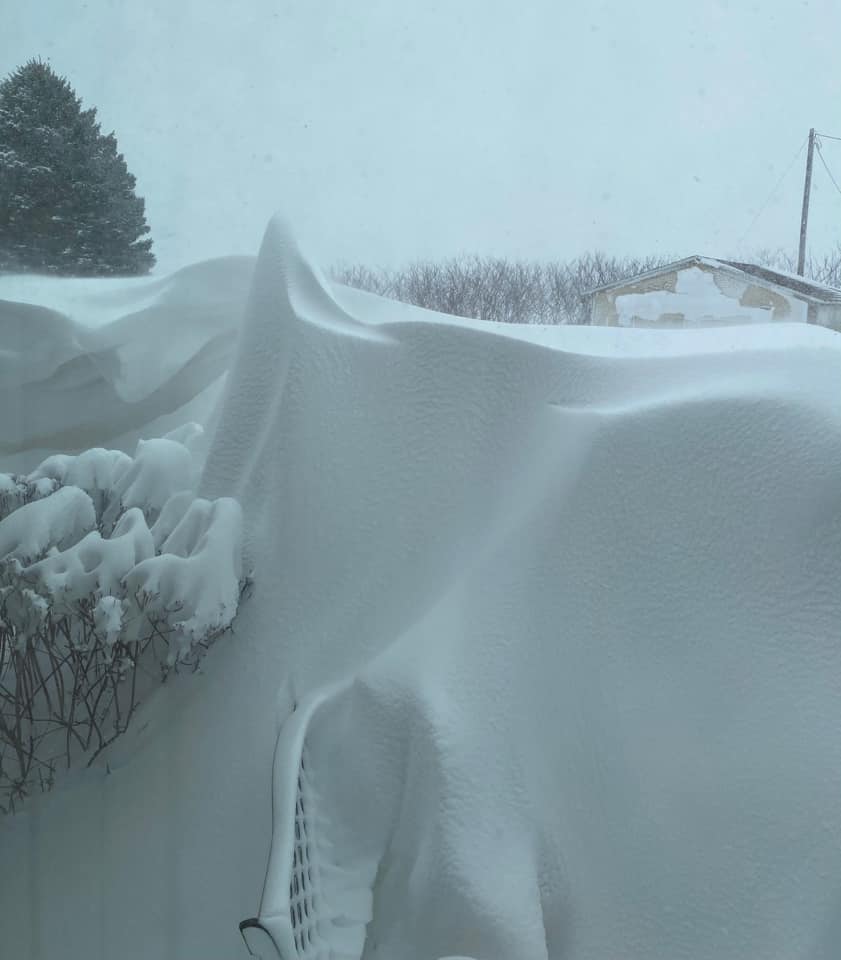
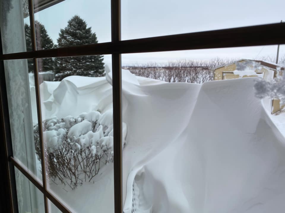
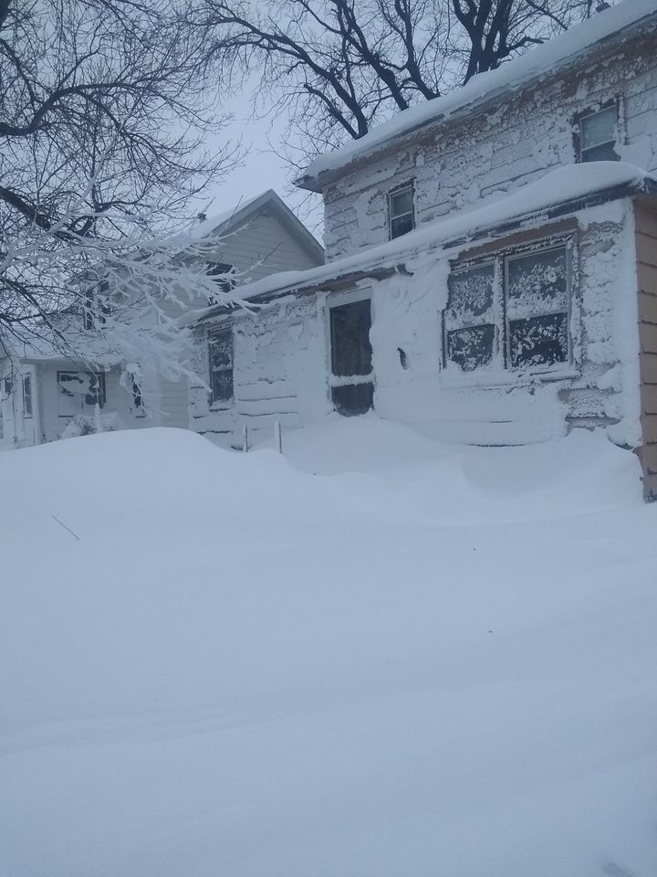
A strong winter storm brought high winds and cold rain, then snow to much of the region. This combination of light to moderate snow, along with 40 to 60+ mph wind gusts, led to blizzard conditions over parts of South Dakota, Minnesota, Nebraska, and Iowa on January 14th and 15th, 2021. This storm system caused the closure of Interstate 29 in eastern South Dakota, as well as Interstate 90 from Sioux Falls east, into south central Minnesota late Thursday evening into the early morning hours Friday. Several state highways in Minnesota were also closed for several hours. Even after they opened, portions of these highways had to be re-closed to due multiple accidents, including jack-knifed semi trucks/trailers. |
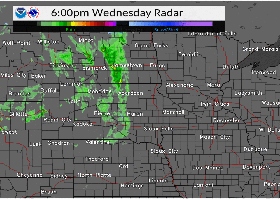 48-hour Radar Loop of the Blizzard |
 |
 |
 |
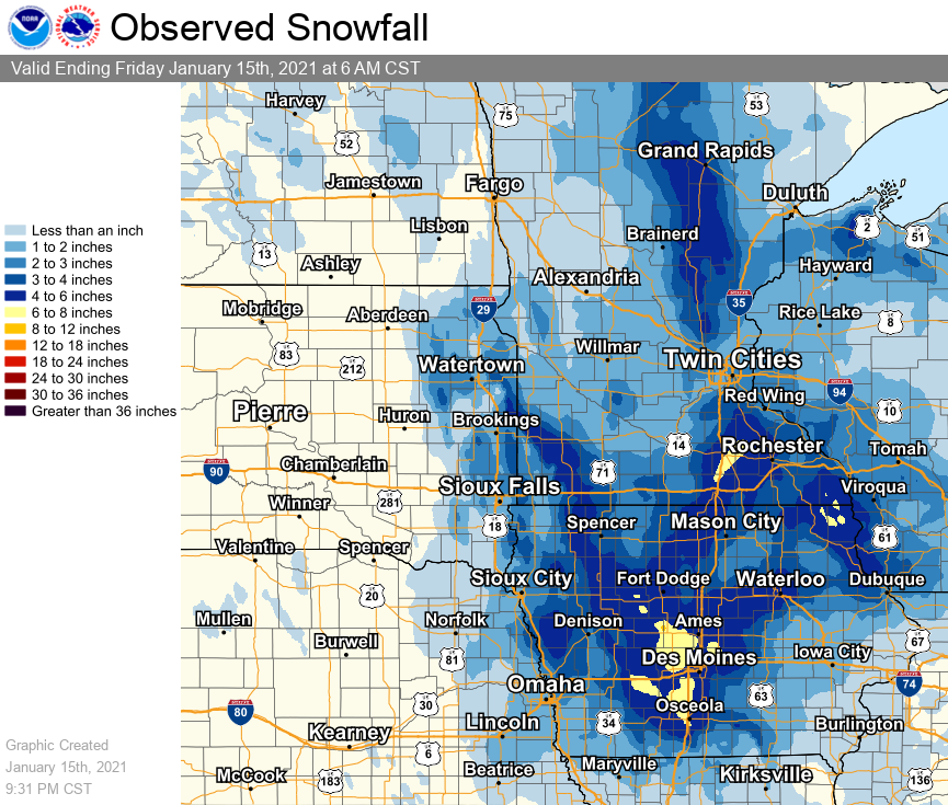
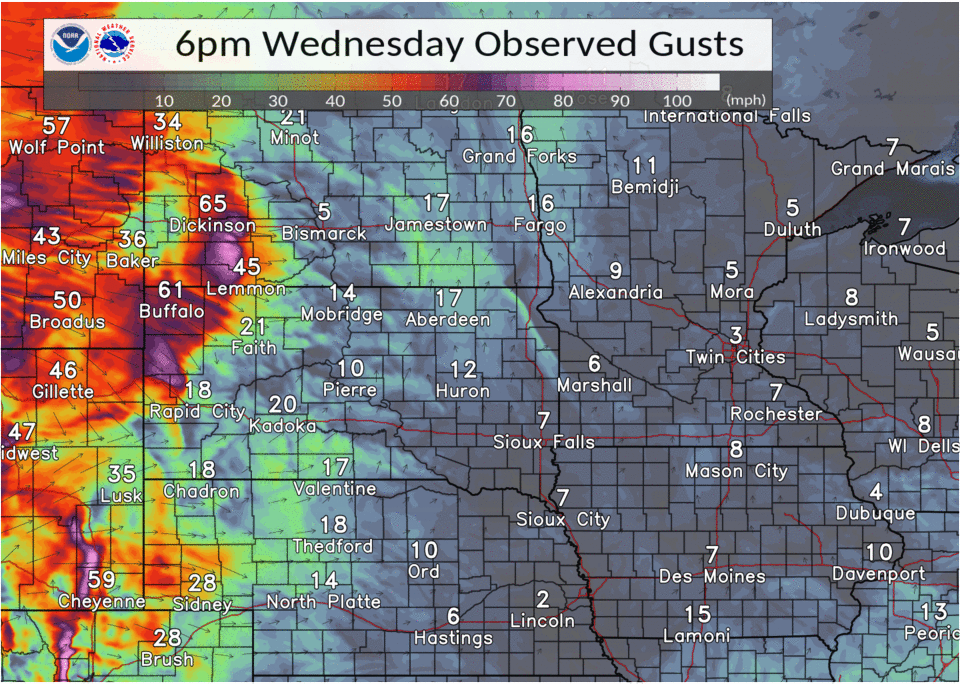
| Regional Snowfall Map | Loop showing hourly peak wind gusts 6pm Wednesday, January 13, through 6pm Thursday, January 14, 2021 |
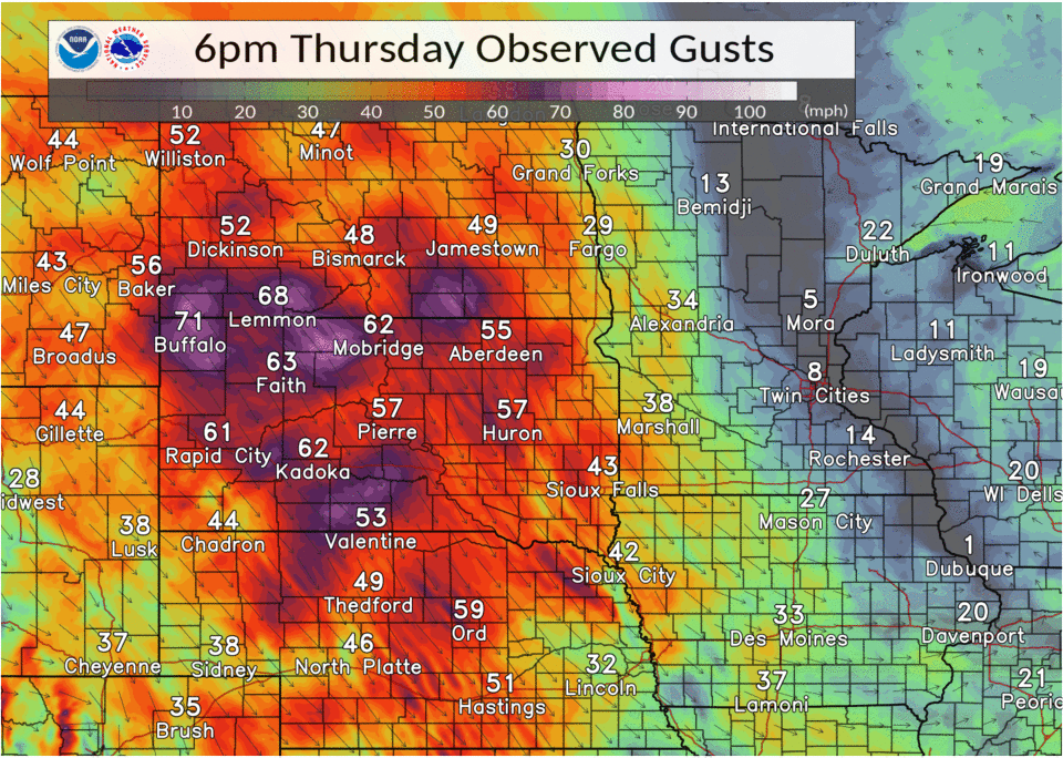
Loop showing hourly peak wind gusts 6pm Thursday, January 14, through 6pm Friday, January 15, 2021 |
Strong Winds:
This strong mid January storm brought strong winds to much of the Intermountain West and Northern Plains. Winds in some locations gusted over 60 mph. Here is a look at the peak wind gusts from the storm.
Wind
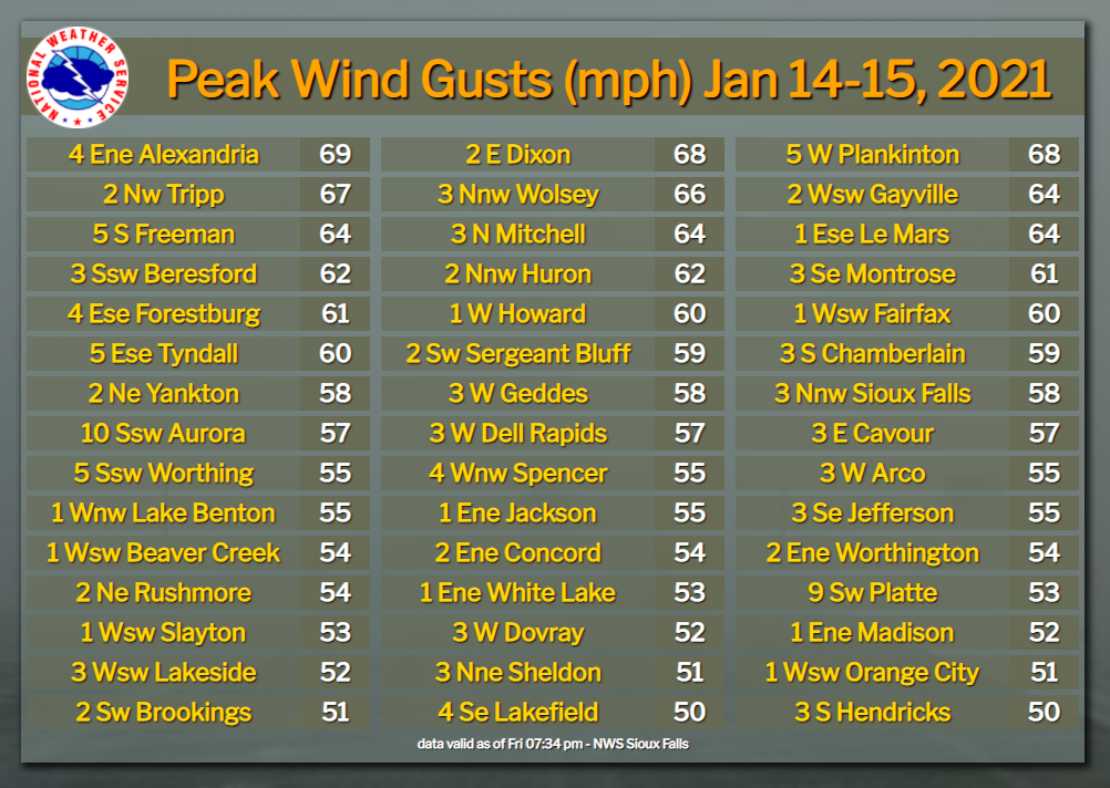
Text listing of peak wind gusts, including data sources |
|
Location                     Speed     Time/Date       Provider
SD RWIS Alexandria           69 MPH    0758 PM 01/14   SDDOT
SD RWIS Plankinton           68 MPH    0818 PM 01/14   SDDOT
SD RWIS Dixon Junction of SD 68 MPH    0434 PM 01/14   SDDOT
SD RWIS Tripp                67 MPH    0347 AM 01/15   SDDOT
SD RWIS Wolsey               66 MPH    0444 PM 01/14   SDDOT
SD RWIS Freeman              64 MPH    0828 PM 01/14   SDDOT
SD RWIS Gayville             64 MPH    0630 PM 01/14   SDDOT
Le Mars                      64 MPH    0221 AM 01/15   CWOP
Mitchell Municipal Airport   64 MPH    0353 PM 01/14   ASOS
SD RWIS Beresford            62 MPH    0250 AM 01/15   SDDOT
Huron Regional Airport       62 MPH    0255 PM 01/14   ASOS
SD RWIS Montrose             61 MPH    0444 PM 01/14   SDDOT
SD RWIS Forestburg           61 MPH    0728 PM 01/14   SDDOT
SD RWIS Tyndall              60 MPH    0949 PM 01/14   SDDOT
SD RWIS Howard Junction of S 60 MPH    0115 PM 01/14   SDDOT
Butte 8NNW                   60 MPH    0202 PM 01/14   CWOP
Chamberlain Municipal Airpor 59 MPH    0335 PM 01/14   ASOS
Sioux City Airport           59 MPH    1252 AM 01/15   ASOS
Sioux Falls Airport          58 MPH    0456 AM 01/15   ASOS
Yankton Municipal Airport    58 MPH    0556 AM 01/15   AWOS
Lake Andes RAWS              58 MPH    0641 AM 01/15   RAWS
SD RWIS Dell Rapids          57 MPH    0549 AM 01/15   SDDOT
SD RWIS Cavour               57 MPH    0200 PM 01/14   SDDOT
SD RWIS Ward                 57 MPH    1239 PM 01/14   SDDOT
SD RWIS Davis                55 MPH    0105 PM 01/14   SDDOT
SD RWIS North Sioux City     55 MPH    0428 AM 01/15   SDDOT
Ivanhoe                      55 MPH    0240 AM 01/15   CWOP
Jackson Airport              55 MPH    1255 AM 01/15   AWOS
Spencer Municipal Airport    55 MPH    0353 AM 01/15   ASOS
Lake Benton US-14 Mile Post  55 MPH    0201 AM 01/15   MNDOT
Worthington Airport          54 MPH    0556 AM 01/15   AWOS
Beaver Creek I-90 Mile Post  54 MPH    1230 AM 01/15   MNDOT
I-90 Mile Post 35            54 MPH    0110 AM 01/15   MNDOT
Concord 2E                   54 MPH    0825 PM 01/14   NE-MESO
Platte                       53 MPH    0435 PM 01/14   CWOP
Slayton Municipal Airport    53 MPH    0133 AM 01/15   AWOS
WHITE LAKE                   53 MPH    0130 PM 01/14   SDSMESO
|
Location                     Speed     Time/Date       Provider
Madison Airport              52 MPH    0435 PM 01/14   AWOS
Storm Lake Airport           52 MPH    1115 PM 01/14   AWOS
Dovray MN-30 Mile Post 49    52 MPH    0620 AM 01/15   MNDOT
Brookings Municipal Airport  51 MPH    0256 PM 01/14   AWOS
Sheldon Airport              51 MPH    0555 AM 01/15   AWOS
Alton (IA10)                 51 MPH    0730 AM 01/15   IADOT
I-90 Mile Post 67            50 MPH    0115 AM 01/15   MNDOT
Hendricks MN-19 Mile Post 2  50 MPH    0205 AM 01/15   MNDOT
SD RWIS Arlington            49 MPH    0909 PM 01/14   SDDOT
FLANDREAU                    49 MPH    0355 AM 01/15   SDSMESO
Canova                       49 MPH    0805 PM 01/14   CWOP
PARKSTON                     49 MPH    0720 PM 01/14   SDSMESO
2 ENE Truesdale              49 MPH    0721 AM 01/15   IADOT
BROOKINGS                    48 MPH    0220 PM 01/14   SDSMESO
Milford                      48 MPH    0617 AM 01/15   CWOP
BERESFORD                    47 MPH    0340 AM 01/15   SDSMESO
Marshall Municipal Airport   47 MPH    0356 AM 01/15   AWOS
Tracy Airport                47 MPH    0135 AM 01/15   AWOS
SF LANDFLL                   47 MPH    0800 PM 01/14   SDSMESO
Platte                       46 MPH    0701 AM 01/15   CWOP
South Sioux City             46 MPH    0300 AM 01/15   CWOP
Luverne                      46 MPH    0916 PM 01/14   CWOP
Luverne Airport              46 MPH    0115 AM 01/15   AWOS
MN-71 Mile Post 43           46 MPH    0720 PM 01/14   MNDOT
COLTON                       45 MPH    0415 PM 01/14   SDSMESO
Le Mars Airport              45 MPH    0235 AM 01/15   AWOS
Pipestone Airport            45 MPH    1115 PM 01/14   AWOS
Sioux Center                 44 MPH    0933 PM 01/14   CWOP
Lakefield                    44 MPH    0506 AM 01/15   CWOP
Windom Municipal Airport     44 MPH    0815 PM 01/14   AWOS
Redstone RAWS                44 MPH    0521 AM 01/15   RAWS
BALTIC                       43 MPH    0450 AM 01/15   SDSMESO
Loess Hills Tnc Broken       41 MPH    0211 AM 01/15   RAWS
Cherokee Municipal Airport   41 MPH    0715 AM 01/15   AWOS
OAK LAKE                     41 MPH    0145 AM 01/15   SDSMESO
VOLGA                        41 MPH    0255 PM 01/14   SDSMESO
Tyler                        40 MPH    0434 PM 01/14   CWOP
|
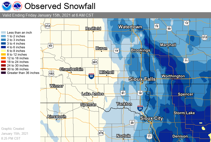
Snow/Ice
Here is a map and listing of snowfall reports from the January 14-15, 2021 Blizzard.
 |
|||||||||||||||
| Storm Total Snowfall Map | |||||||||||||||
|
PRELIMINARY LOCAL STORM REPORT...SUMMARY
NATIONAL WEATHER SERVICE SIOUX FALLS SD
254 PM CST SAT JAN 16 2021

..TIME...   ...EVENT...      ...CITY LOCATION...     ...LAT.LON...
..DATE...   ....MAG....      ..COUNTY LOCATION..ST.. ...SOURCE....
            ..REMARKS..

1210 PM     SNOW             REMSEN                  42.81N 95.98W
01/16/2021  M3.9 INCH        PLYMOUTH           IA   CO-OP OBSERVER

            STORM TOTAL SNOWFALL FOR CO-OP OBSERVER
            STATION RMSI4 REMSEN.

0900 AM     SNOW             1 SSE MADISON           43.99N 97.09W
01/16/2021  M2.8 INCH        LAKE               SD   CO-OP OBSERVER

            STORM TOTAL SNOWFALL FOR CO-OP OBSERVER
            STATION MRFS2 MADISON 2SE.

0900 AM     SNOW             6 NNE ELK POINT         42.76N 96.65W
01/16/2021  M2.2 INCH        UNION              SD   COCORAHS

            STORM TOTAL SNOWFALL FOR COCORAHS OBSERVER
            STATION SD-UN-2 ELK POINT 5.6 NNE.

0847 AM     SNOW             1 N SPENCER             43.17N 95.15W
01/16/2021  M4.0 INCH        CLAY               IA   CO-OP OBSERVER

            STORM TOTAL SNOWFALL FOR CO-OP OBSERVER
            STATION 3SE SPENCER 1 N.

0800 AM     SNOW             1 NNW PIPESTONE         44.01N 96.33W
01/16/2021  M6.0 INCH        PIPESTONE          MN   CO-OP OBSERVER

            STORM TOTAL SNOWFALL FOR CO-OP OBSERVER
            STATION PIPM5 PIPESTONE 1 NNW.

0800 AM     SNOW             1 N MARSHALL            44.47N 95.79W
01/16/2021  M2.5 INCH        LYON               MN   CO-OP OBSERVER

            STORM TOTAL SNOWFALL FOR CO-OP OBSERVER
            STATION MMLM5 MARSHALL.

0800 AM     SNOW             HILLS                   43.53N 96.36W
01/16/2021  M3.0 INCH        ROCK               MN   COCORAHS

            STORM TOTAL SNOWFALL FOR COCORAHS OBSERVER
            STATION MN-RK-5 HILLS 0.2 NW.

0800 AM     SNOW             1 NE BROOKINGS          44.32N 96.77W
01/16/2021  M4.2 INCH        BROOKINGS          SD   CO-OP OBSERVER

            STORM TOTAL SNOWFALL FOR CO-OP OBSERVER
            STATION BROS2 BROOKINGS 2 NE.

0800 AM     SNOW             TYNDALL                 42.99N 97.86W
01/16/2021  M0.7 INCH        BON HOMME          SD   CO-OP OBSERVER

            STORM TOTAL SNOWFALL FOR CO-OP OBSERVER
            STATION TYNS2 TYNDALL.

0800 AM     SNOW             3 NW WINDOM             43.89N 95.16W
01/16/2021  M4.0 INCH        COTTONWOOD         MN   CO-OP OBSERVER

            STORM TOTAL SNOWFALL FOR CO-OP OBSERVER
            STATION WDOM5 2.6 NW WINDOM.

0700 AM     SNOW             MONTROSE                43.70N 97.19W
01/16/2021  M1.8 INCH        MCCOOK             SD   CO-OP OBSERVER

            STORM TOTAL SNOWFALL FOR CO-OP OBSERVER
            STATION MONS2 MONTROSE.

0700 AM     SNOW             ORANGE CITY             43.00N 96.05W
01/16/2021  M2.5 INCH        SIOUX              IA   CO-OP OBSERVER

            STORM TOTAL SNOWFALL FOR CO-OP OBSERVER
            STATION ORCI4 ORANGE CITY.

0700 AM     SNOW             2 N CHESTER             43.93N 96.93W
01/16/2021  M2.9 INCH        LAKE               SD   CO-OP OBSERVER

            STORM TOTAL SNOWFALL FOR CO-OP OBSERVER
            STATION CHES2 2.4 N CHESTER.

0700 AM     SNOW             5 NW HOLSTEIN           42.55N 95.61W
01/16/2021  M4.0 INCH        IDA                IA   CO-OP OBSERVER

            STORM TOTAL SNOWFALL FOR CO-OP OBSERVER
            STATION HLSI4 HOLSTEIN 5 NW.

0700 AM     SNOW             1 NNW CANTON            43.31N 96.59W
01/16/2021  M2.5 INCH        LINCOLN            SD   CO-OP OBSERVER

            STORM TOTAL SNOWFALL FOR CO-OP OBSERVER
            STATION CNNS2 CANTON.

0700 AM     SNOW             3 NW EVERLY             43.18N 95.37W
01/16/2021  M5.0 INCH        CLAY               IA   CO-OP OBSERVER

            STORM TOTAL SNOWFALL FOR CO-OP OBSERVER
            STATION EVYI4 2.8 NW EVERLY.

0700 AM     SNOW             SHELDON                 43.18N 95.85W
01/16/2021  M3.5 INCH        O`BRIEN            IA   CO-OP OBSERVER

            STORM TOTAL SNOWFALL FOR CO-OP OBSERVER
            STATION SHDI4 SHELDON.

0700 AM     SNOW             1 E SPIRIT LAKE         43.42N 95.10W
01/16/2021  M5.2 INCH        DICKINSON          IA   CO-OP OBSERVER

            STORM TOTAL SNOWFALL FOR CO-OP OBSERVER
            STATION SPRI4 0.6 E SPIRIT LAKE.

0700 AM     SNOW             11 N COLMAN             44.14N 96.80W
01/16/2021  M1.2 INCH        MOODY              SD   COCORAHS

            STORM TOTAL SNOWFALL FOR COCORAHS OBSERVER
            STATION SD-MY-11 COLMAN 10.6 N.

0630 AM     SNOW             HOWARD                  44.01N 97.53W
01/16/2021  M0.7 INCH        MINER              SD   CO-OP OBSERVER

            STORM TOTAL SNOWFALL FOR CO-OP OBSERVER
            STATION HOWS2 HOWARD.

0630 AM     SNOW             2 ESE YANKTON           42.88N 97.36W
01/16/2021  M1.5 INCH        YANKTON            SD   CO-OP OBSERVER

            STORM TOTAL SNOWFALL FOR CO-OP OBSERVER
            STATION YTNS2 YANKTON 2 ESE.

0600 AM     SNOW             SIOUX CITY              42.40N 96.36W
01/16/2021  M2.0 INCH        WOODBURY           IA   OFFICIAL NWS OBS

            STORM TOTAL SNOWFALL.

0600 AM     SNOW             HURLEY                  43.28N 97.09W
01/16/2021  M0.8 INCH        TURNER             SD   COCORAHS

            STORM TOTAL SNOWFALL FOR COCORAHS OBSERVER
            STATION SD-TR-9 HURLEY 0.2 S.

0600 AM     SNOW             SIOUX FALLS             43.59N 96.73W
01/16/2021  M2.1 INCH        MINNEHAHA          SD   OFFICIAL NWS OBS

            STORM TOTAL SNOWFALL.

0600 AM     SNOW             0.2 WSW EDGERTON        43.88N 96.14W
01/16/2021  M4.0 INCH        PIPESTONE          MN   COCORAHS

            STORM TOTAL SNOWFALL FOR COCORAHS OBSERVER
            STATION MN-PS-6 EDGERTON 0.2 WSW.

1200 AM     SNOW             4 NW OKOBOJI            43.43N 95.18W
01/16/2021  M4.0 INCH        DICKINSON          IA   CO-OP OBSERVER

            STORM TOTAL SNOWFALL FOR CO-OP OBSERVER
            STATION VICI4 4.0 N WAHPETON.

0600 PM     SNOW             MENNO                   43.24N 97.57W
01/15/2021  M1.0 INCH        HUTCHINSON         SD   CO-OP OBSERVER

            STORM TOTAL SNOWFALL FOR CO-OP OBSERVER
            STATION MNOS2 MENNO.

0500 PM     SNOW             2 E CONCORD             42.38N 96.96W
01/15/2021  M4.0 INCH        DIXON              NE   CO-OP OBSERVER

            STORM TOTAL SNOWFALL FOR CO-OP OBSERVER
            STATION NESN1 CONCORD.

0400 PM     SNOW             PRIMGHAR                43.09N 95.63W
01/15/2021  M5.0 INCH        O`BRIEN            IA   CO-OP OBSERVER

            STORM TOTAL SNOWFALL AT CO-OP OBSERVER
            STATION PGHI4 PRIMGHAR.


&&
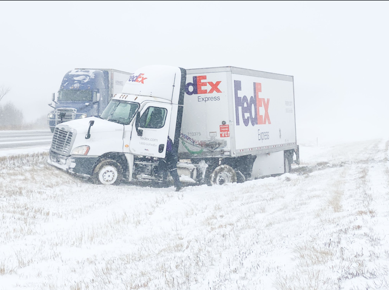
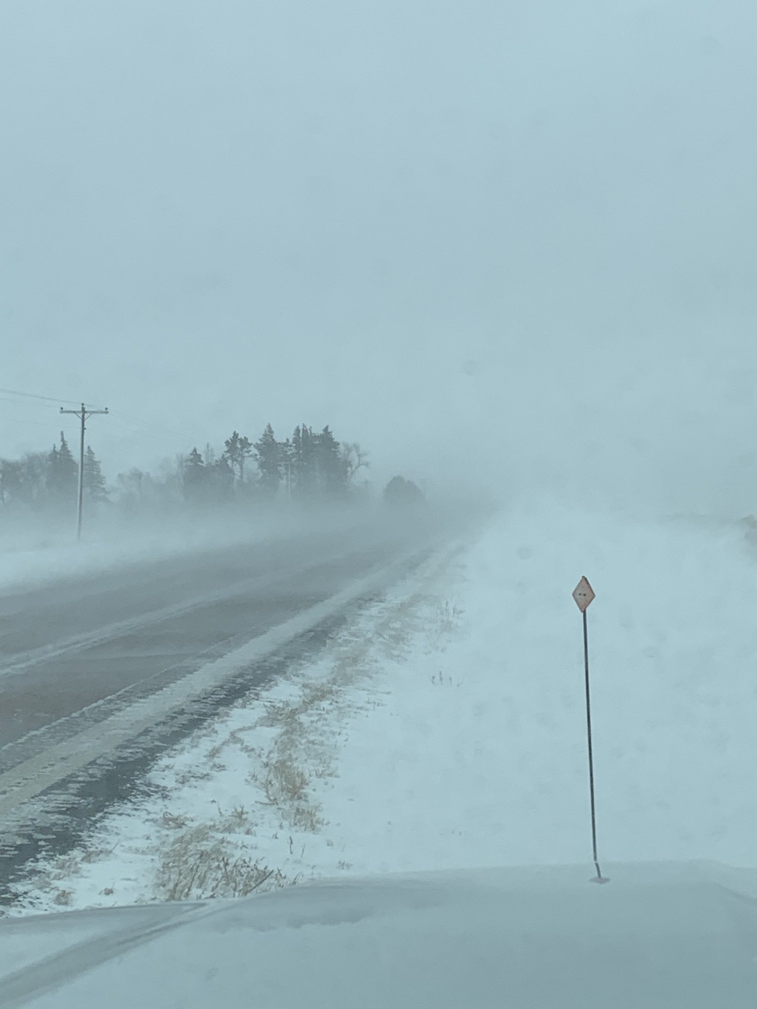
Photos & Video
|
|||||||||||||||


 Weather Story
 Weather Map
 Local Radar