Overview
|
A prolonged winter storm impacted the broader region December 12-16, 2022. This system not only produced rain, freezing rain, snow, and gusty winds - but also resulted in a significant number of travel impacts across the region. This system started off by producing a combination of freezing drizzle/rain on the evening of December 12, with the greatest ice impacts noted east of I-29, and especially across SW Minnesota. A switch to rain then occurred on December 13 as temperatures warmed, which resulted in a few daily rainfall records being broken across our area. After seeing somewhat of a lull in precipitation for most of the day December 14, we saw snow develop later that afternoon/evening as temperatures cooled. Snow then continued through December 15, and finally began to taper off by December 16. Winds during this time also became notably gusty, resulting in widespread reduced visibilities across the region. In regard to snowfall totals, the highest amounts generally fell along and west of the James River - across central SD, with higher amounts also report north of Hwy-14. |
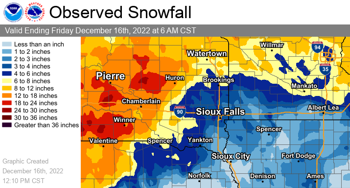
Snowfall Totals: Valid from 6 AM December 12 - 6 AM December 16 |
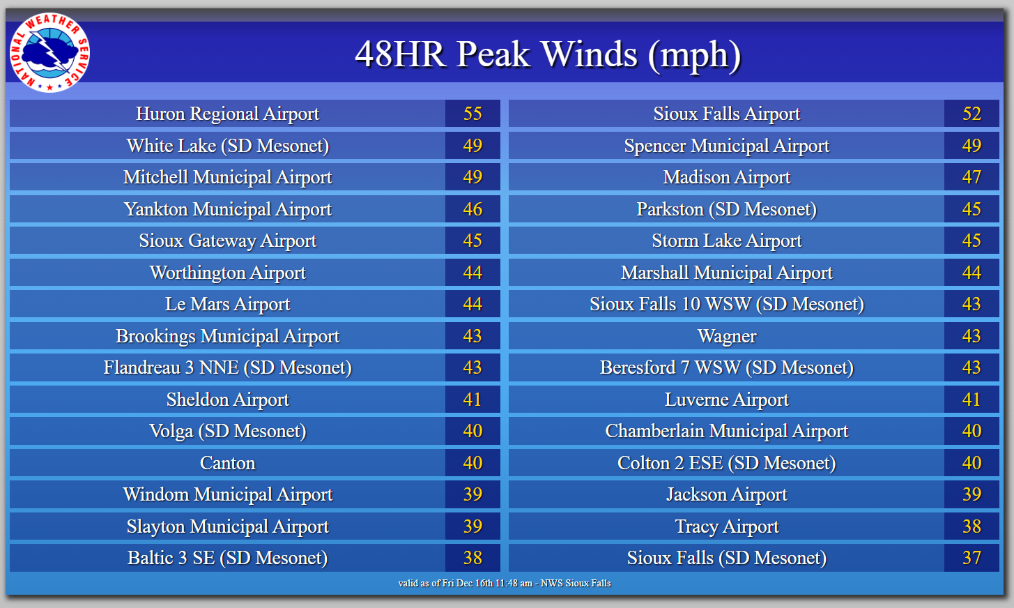
Wind:
While gusty winds were observed at the start of this system, the strongest winds actually occurred on the backside of this event and coincided with falling snow, which resulted in hazardous travel for many across the region. The strongest gusts were noted at both the Huron and Sioux Falls Airport, with gusts in the 40s to upper 30s common elsewhere.
 |
|
Peak Winds (MPH) observed across the region between December 14 - December 16. |
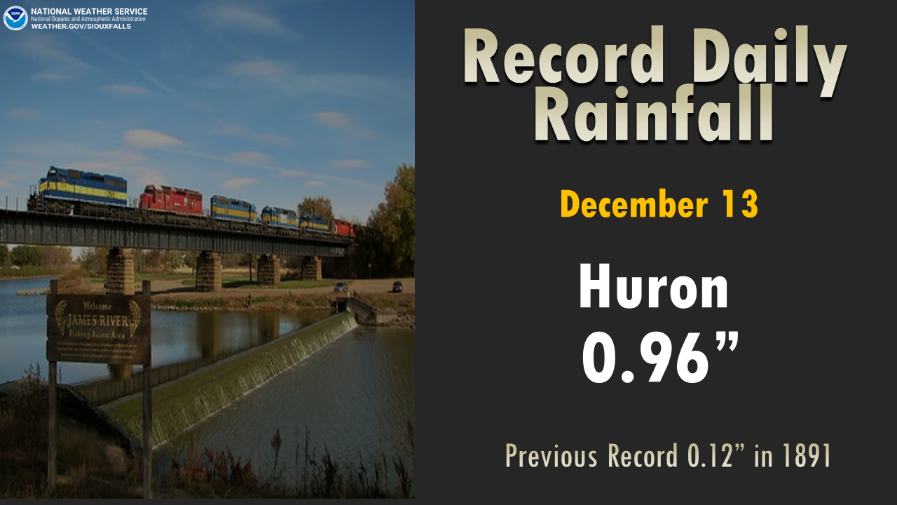
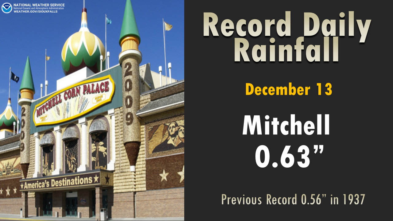
Rain
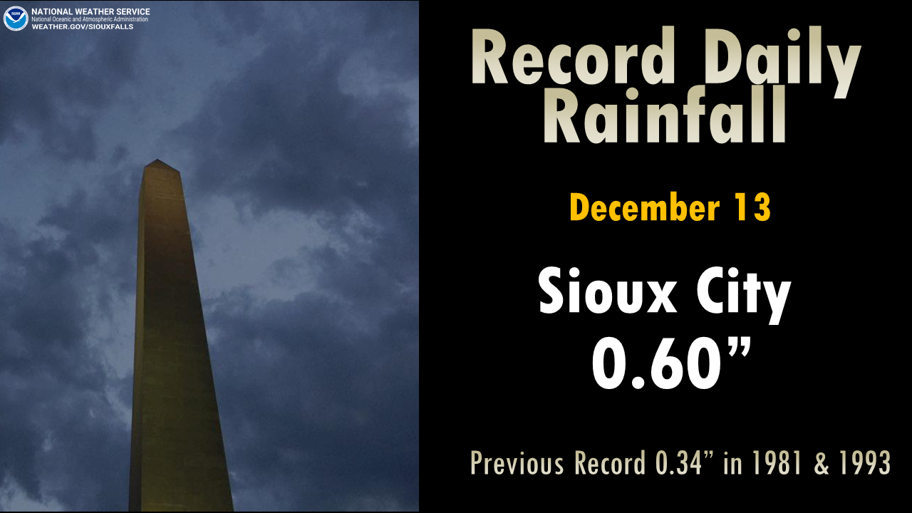
Daily rainfall records were broken at all of our climate sites on December 13, 2022.
 |
 |
 |
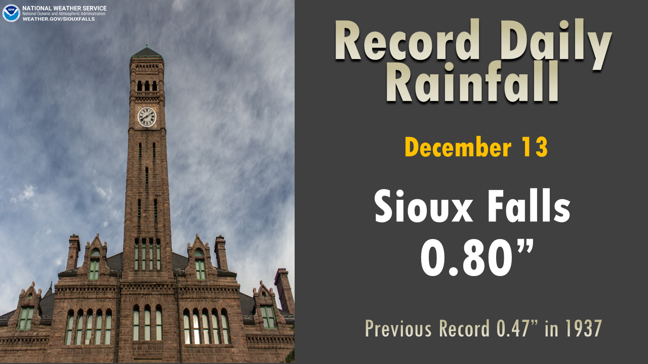 |
| Huron, SD | Mitchell, SD | Sioux City, IA | Sioux Falls, SD |
Snow/Ice Reports
PRELIMINARY LOCAL STORM REPORT...SUMMARY
NATIONAL WEATHER SERVICE SIOUX FALLS SD
144 PM CST FRI DEC 16 2022
..TIME... ...EVENT... ...CITY LOCATION... ...LAT.LON...
..DATE... ....MAG.... ..COUNTY LOCATION..ST.. ...SOURCE....
..REMARKS..
1112 PM FREEZING RAIN MADISON 44.01N 97.11W
12/12/2022 E0.13 INCH LAKE SD PUBLIC
REPORT FROM SOCIAL MEDIA.
1130 PM FREEZING RAIN LENNOX 43.35N 96.90W
12/12/2022 E0.10 INCH LINCOLN SD PUBLIC
GLAZE OF ICE ON MOST SURFACES, REPORT FROM
SOCIAL MEDIA.
1144 PM FREEZING RAIN 4 WNW ROWENA 43.55N 96.63W
12/12/2022 E0.10 INCH MINNEHAHA SD NWS EMPLOYEE
GLAZE OF ICE COVERING MOST SURFACES.
1153 PM FREEZING RAIN 1 S BROOKINGS 44.29N 96.79W
12/12/2022 E0.10 INCH BROOKINGS SD PUBLIC
MOST SURFACES COVERED BY A LIGHT GLAZE OF
ICE.
1245 AM FREEZING RAIN ROCK RAPIDS 43.43N 96.17W
12/13/2022 E0.02 INCH LYON IA PUBLIC
LIGHT GLAZE OF ICE ON MOST SURFACES AROUND
TOWN, REPORT FROM SOCIAL MEDIA.
1246 AM FREEZING RAIN LINN GROVE 42.89N 95.24W
12/13/2022 M0.20 INCH BUENA VISTA IA PUBLIC
MEASURED ON A TREE BRANCH, REPORT FROM
SOCIAL MEDIA.
0100 AM ICE STORM WOONSOCKET 44.06N 98.27W
12/13/2022 SANBORN SD PUBLIC
SOCIAL MEDIA REPORT OF BETWEEN 1/4 AND 1/2
INCH ICE ON BRANCHES.
0230 AM ICE STORM SANBORN 43.18N 95.66W
12/13/2022 O'BRIEN IA PUBLIC
SOCIAL MEDIA REPORT OF 0.25 INCH ICE
ACCUMULATION ON ROAD SIGNS AND TREES.
ESTIMATES THAT IT MAY HAVE BEEN MORE, AS
THERE ARE MULTIPLE 4-6 INCH DIAMETER
BRANCHES DOWN AND A FEW 12 INCH BRANCHES AS
WELL.
0230 AM FREEZING RAIN SANBORN 43.18N 95.66W
12/13/2022 M0.25 INCH O'BRIEN IA PUBLIC
MEASURED ON A TREE BRANCH, AND NOTED TREE
BRANCHES CRACKING AND BREAKING, ALONG WITH
ARCING POWER LINES. REPORT FROM SOCIAL
MEDIA.
0700 AM ICE STORM TYLER 44.28N 96.14W
12/13/2022 LINCOLN MN PUBLIC
SOCIAL MEDIA REPORT OF MULTIPLE 8-10 INCH
BRANCHES DOWN AS RESULT OF ICE STORM.
0700 AM ICE STORM 2 ENE ARCO 44.40N 96.14W
12/13/2022 LINCOLN MN PUBLIC
SOCIAL MEDIA REPORT WITH PICTURES OF
ESTIMATED 6-8 INCH BRANCHES DOWNED AS RESULT
OF ICE STORM.
0700 AM ICE STORM 1 S EDGERTON 43.86N 96.13W
12/13/2022 PIPESTONE MN PUBLIC
SOCIAL MEDIA REPORT OF A QUARTER INCH ICE
ACCUMULATION.
0700 AM FREEZING RAIN BREWSTER 43.70N 95.46W
12/13/2022 E0.10 INCH NOBLES MN PUBLIC
SOCIAL MEDIA REPORT OF ICE ON BRANCHES.
0720 AM FREEZING RAIN HULL 43.19N 96.13W
12/13/2022 M0.13 INCH SIOUX IA TRAINED SPOTTER
AROUND 1/8 INCH ICE ACCUMULATION.
0723 AM FREEZING RAIN WOONSOCKET 44.05N 98.27W
12/13/2022 E0.10 INCH SANBORN SD PUBLIC
SOCIAL MEDIA REPORT.
0730 AM ICE STORM 6 SSE MADISON 43.93N 97.07W
12/13/2022 LAKE SD EMERGENCY MNGR
REPORTS 1/2-3/4 INCH OF ICE ON FENCE POSTS
WITH PICTURES. NEARLY 1 INCH OF ICE ON THE
EAST FACE OF STREET SIGNS. ALSO REPORTS
BROKEN BRANCHES 4-6 INCHES IN DIAMETER.
0730 AM FREEZING RAIN 3 ESE SIOUX FALLS 43.54N 96.68W
12/13/2022 M0.15 INCH MINNEHAHA SD NWS EMPLOYEE
CORRECTS PREVIOUS ICE STORM REPORT FROM 3
ESE SIOUX FALLS. REPORTED 1/4 INCH OF ICE ON
TREE BRANCH IN YARD.
0745 AM ICE STORM ADRIAN 43.63N 95.93W
12/13/2022 NOBLES MN PUBLIC
SOCIAL MEDIA REPORT WITH PICTURE, 1/4 INCH
ICE ON TREE BRANCHES.
0746 AM FREEZING RAIN 1 S HULL 43.18N 96.13W
12/13/2022 E0.13 INCH SIOUX IA PUBLIC
SOCIAL MEDIA REPORT 1/8TH INCH ICE.
0758 AM ICE STORM 5 W ELKTON 44.24N 96.58W
12/13/2022 BROOKINGS SD PUBLIC
CORRECTS PREVIOUS ICE STORM REPORT FROM 5 W
ELKTON. SOCIAL MEDIA REPORT WITH PICTURE OF
1/4 ICE ON DECK RAILING. ALSO 6-8 INCH
BRANCHES DOWN.
0817 AM FREEZING RAIN EDGERTON 43.87N 96.13W
12/13/2022 E0.20 INCH PIPESTONE MN PUBLIC
SOCIAL MEDIA REPORT.
0824 AM FREEZING RAIN 1 SE TEA 43.44N 96.82W
12/13/2022 E0.15 INCH LINCOLN SD PUBLIC
SOCIAL MEDIA REPORT.
0827 AM ICE STORM CHEROKEE 42.75N 95.55W
12/13/2022 CHEROKEE IA PUBLIC
SOCIAL MEDIA REPORT WITH PICTURE OF MEDIUM
BRANCHES DOWN, ESTIMATE OF 6 INCH BRANCHES.
0829 AM ICE STORM PARKER 43.40N 97.14W
12/13/2022 TURNER SD PUBLIC
SOCIAL MEDIA REPORT WITH PICTURE OF 0.5 INCH
ICE ON BRANCH.
0830 AM ICE STORM LARCHWOOD 43.46N 96.44W
12/13/2022 LYON IA PUBLIC
SOCIAL MEDIA PICTURE OF LARGE TREE LIMBS
DOWN IN TOWN.
0834 AM ICE STORM 2 WSW BROOKINGS 44.29N 96.82W
12/13/2022 BROOKINGS SD PUBLIC
SOCIAL MEDIA REPORT OF 0.35 INCHES ICE SOUTH
OF BROOKINGS AIRPORT.
0859 AM FREEZING RAIN 1 S IRETON 42.96N 96.32W
12/13/2022 M0.13 INCH SIOUX IA PUBLIC
SOCIAL MEDIA REPORT WITH PICTURE OF 1/8 INCH
ICE ON TREE BRANCH. ALSO REPORTED POWER
OUTAGES AND BRANCHES DOWN.
0900 AM ICE STORM 2 WSW BROOKINGS 44.30N 96.82W
12/13/2022 BROOKINGS SD PUBLIC
SOCIAL MEDIA REPORT OF 0.35 INCHES OF ICE.
0900 AM FREEZING RAIN HOWARD 44.01N 97.52W
12/13/2022 E0.20 INCH MINER SD PUBLIC
AVERAGE ACCUMULATION ON TREES VIA SOCIAL
MEDIA.
0907 AM ICE STORM 1 S BRUCE 44.42N 96.89W
12/13/2022 BROOKINGS SD PUBLIC
SOCIAL MEDIA REPORT WITH PICTURE OF 1/2 INCH
ICE AND LARGE BRANCHES DOWN. ESTIMATE 8 INCH
BRANCH.
1000 AM ICE STORM RAMONA 44.12N 97.22W
12/13/2022 LAKE SD PUBLIC
SOCIAL MEDIA REPORT OF 3/8 INCHES OF ICE
WITH PICTURE.
1000 AM ICE STORM HARDWICK 43.78N 96.20W
12/13/2022 ROCK MN PUBLIC
SOCIAL MEDIA REPORT WITH PICTURE OF 3/8 INCH
ICE. ALSO REPORTED SEVERAL LARGE BRANCHES
DOWN. ICE ESTIMATE IS LOW AS IT HAD ALREADY
STARTED MELTING. ALSO REPORTED 5-6 INCH
DIAMETER BRANCHES DOWN.
1008 AM FREEZING RAIN IVANHOE 44.46N 96.25W
12/13/2022 E0.10 INCH LINCOLN MN EMERGENCY MNGR
NOT CERTAIN ON ICE AMOUNT, BUT RATHER THIN.
ROADS ARE SLUSHY FROM RAIN, MELTING SNOW,
AND ICE. NO POWER OUTAGES OR TREE BRANCHES
DOWN.
1015 AM FREEZING RAIN MARSHALL 44.45N 95.79W
12/13/2022 E0.25 INCH LYON MN LAW ENFORCEMENT
1/8 TO 1/4 INCH OF ICE ON TREES IN MARSHALL,
BUT NO TRAFFIC PROBLEMS ON SLUSHY ROADS. NO
POWER OUTAGES OR BRANCHES DOWN.
1026 AM ICE STORM 1 S LARCHWOOD 43.44N 96.44W
12/13/2022 LYON IA PUBLIC
SOCIAL MEDIA REPORT WITH PICTURE OF 0.25 ICE
ACCUMULATION AND LARGE TREE BRANCHES DOWN.
BRANCH SIZE ESTIMATE 9-12 INCHES DIAMETER.
1035 AM ICE STORM SLAYTON 43.99N 95.75W
12/13/2022 MURRAY MN EMERGENCY MNGR
TOTAL ICE ACCUMULATION 1/3 TO 1/2 INCH
BEFORE MIDNIGHT. ROADS ARE SLUSHY NOW. 3
POWER OUTAGES OVERNIGHT. 1 CAR ACCIDENT FROM
SNAPPING POWER POLE.
1045 AM FREEZING RAIN WINDOM 43.87N 95.12W
12/13/2022 E0.10 INCH COTTONWOOD MN EMERGENCY MNGR
ABOUT 1/10 INCH OF ICE LAST NIGHT, BUT ROADS
ARE SLUSHY NOW, WITH A FEW SLICK SPOTS.
SIDEWALKS ARE SLICK. NO POWER OUTAGES IN
COUNTY. A FEW SMALL TREE BRANCHES DOWN, LESS
THAN 1 INCH DIAMETER.
1054 AM ICE STORM MELVIN 43.29N 95.61W
12/13/2022 OSCEOLA IA PUBLIC
SOCIAL MEDIA REPORT WITH PICTURES OF 6 INCH
BRANCH DOWN, APPROXIMATELY 0.25 INCHES OF
ICE.
1055 AM FREEZING RAIN LUVERNE 43.65N 96.21W
12/13/2022 E0.13 INCH ROCK MN EMERGENCY MNGR
ABOUT 1/8 INCH ICE ON TREES AND OUTDOOR
SURFACES. TRAFFIC MOVING FAIRLY WELL ON
SLUSHY ROADS. GRAVEL ROADS ARE A LITTLE MORE
SLICK. NO POWER OUTAGES OR TREE BRANCHES
DOWN.
1113 AM ICE STORM 5 WNW ELKTON 44.26N 96.58W
12/13/2022 BROOKINGS SD PUBLIC
SOCIAL MEDIA REPORT WITH PICTURES OF 1/2
INCH ICE.
1115 AM ICE STORM 3 E ORLAND 43.89N 97.13W
12/13/2022 LAKE SD PUBLIC
SOCIAL MEDIA REPORT WITH PICTURE OF 1 INCH
OF ICE ON A BRANCH.
1120 AM ICE STORM HETLAND 44.38N 97.23W
12/13/2022 KINGSBURY SD PUBLIC
SOCIAL MEDIA REPORT WITH PICTURES OF 1/2
INCH ICE.
1128 AM ICE STORM 4 ESE SIOUX FALLS 43.52N 96.65W
12/13/2022 MINNEHAHA SD PUBLIC
SOCIAL MEDIA REPORT 1/4 INCH ICE.
1219 PM FREEZING RAIN JACKSON 43.62N 94.99W
12/13/2022 E0.10 INCH JACKSON MN EMERGENCY MNGR
ABOUT 1/10 INCH OF ICE ON TREES AND ROADS.
TRAFFIC IS MOVING OK TODAY ON SLUSHY ROADS,
AS THE RAIN CONTINUES INTO LUNCHTIME. NO
POWER OUTAGES OR TREE BRANCHES DOWN AROUND
TOWN.
1220 PM ICE STORM TROSKY 43.89N 96.26W
12/13/2022 PIPESTONE MN PUBLIC
SOCIAL MEDIA REPORT WITH PICTURE OF 0.875
INCHES OF ICE ON A BRANCH.
1235 PM FREEZING RAIN FLANDREAU 44.05N 96.60W
12/13/2022 E0.25 INCH MOODY SD EMERGENCY MNGR
ABOUT A QUARTER INCH OF ICE ON TREES AND
ROADS LAST NIGHT, BUT MELTING NOW. TRAFFIC
IS MOVING AROUND OK, BUT A FEW MINOR
ACCIDENTS OCCURRED THIS MORNING. ROADS ARE
SLUSHY NOW, AS RAIN MELTS SOME ICE. FEW
FLICKERS IN POWER THIS MORNING, BUT NO
OUTAGES OR TREE BRANCHES DOWN.
1255 PM FREEZING RAIN SPIRIT LAKE 43.42N 95.11W
12/13/2022 E0.10 INCH DICKINSON IA EMERGENCY MNGR
UNCERTAIN ICE THICKNESS LAST NIGHT, BUT
RATHER THIN. FEW SHORT POWER OUTAGES. A TREE
WENT DOWN IN THE MIDDLE OF TOWN, SNAPPING A
POWER LINE AND BRIEFLY BLOCKING TRAFFIC.
TRAFFIC MOVING AROUND OK TODAY ON SLUSHY
ROADS. MAIN PROBLEM NOW IS WATER POOLING UP
AT ENDS OF BRIDGES FROM RAIN AND MELTING
SNOW.
0110 PM FREEZING RAIN SPENCER 43.15N 95.15W
12/13/2022 E0.20 INCH CLAY IA EMERGENCY MNGR
ABOUT 0.2 INCH OF ICE LAST NIGHT MADE ROADS
QUITE SLICK THROUGH EARLY MORNING. SHERRIFF
ORDERED NO TRAVEL ADVISORY LAST NIGHT. NOT
SLICK NOW, DUE TO RAIN MAKING ROADS JUST
WET. NO POWER OUTAGES REPORTED OR TREE
BRANCHES DOWN AROUND COUNTY.
0400 AM SNOW 8 SSW CHAMBERLAIN 43.71N 99.38W
12/16/2022 M12.3 INCH BRULE SD COCORAHS
COCORAHS STATION SD-BL-10 CHAMBERLAIN 7.5
SSW, 3 DAY TOTAL.
0530 AM SNOW 1 E LE MARS 42.78N 96.15W
12/16/2022 M1.0 INCH PLYMOUTH IA COCORAHS
COCORAHS STATION IA-PL-9 LE MARS 1.0 E, 3
DAY TOTAL.
0600 AM SNOW 3 N SIOUX FALLS 43.59N 96.73W
12/16/2022 M4.9 INCH MINNEHAHA SD CO-OP OBSERVER
CO-OP OBSERVER STATION FSDS2 SIOUX FALLS
NWS, 3 DAY TOTAL.
0600 AM SNOW EDGERTON 43.87N 96.13W
12/16/2022 M2.5 INCH PIPESTONE MN COCORAHS
COCORAHS STATION MN-PS-6 EDGERTON 0.2 WSW, 3
DAY TOTAL.
0600 AM SNOW HURLEY 43.28N 97.09W
12/16/2022 M2.1 INCH TURNER SD COCORAHS
COCORAHS STATION SD-TR-9 HURLEY 0.2 S, 3 DAY
TOTAL.
0600 AM SNOW CLAYTON 43.45N 97.66W
12/16/2022 M10.2 INCH HUTCHINSON SD COCORAHS
COCORAHS STATION SD-HT-16 EMERY 10.8 S, 3
DAY TOTAL.
0630 AM SNOW 2 ESE YANKTON 42.88N 97.36W
12/16/2022 M3.0 INCH YANKTON SD CO-OP OBSERVER
CO-OP OBSERVER STATION YTNS2 YANKTON 2 E, 3
DAY TOTAL.
0700 AM SNOW 4 SW BURKE 43.14N 99.35W
12/16/2022 M13.0 INCH GREGORY SD COCORAHS
COCORAHS STATION SD-GY-15 BURKE 4.2 SW, 3
DAY TOTAL.
0700 AM SNOW 2 S PUKWANA 43.75N 99.18W
12/16/2022 M14.0 INCH BRULE SD COCORAHS
COCORAHS STATION SD-BL-11 PUKWANA 1.9 S, 3
DAY TOTAL.
0700 AM SNOW 10 W DIMOCK 43.50N 98.19W
12/16/2022 M10.2 INCH DOUGLAS SD COCORAHS
COCORAHS STATION SD-DG-1 DIMOCK 10.2 W, 3
DAY TOTAL.
0700 AM SNOW 3 ESE SIOUX FALLS 43.52N 96.67W
12/16/2022 M5.5 INCH MINNEHAHA SD COCORAHS
COCORAHS STATION SD-MH-1 SIOUX FALLS 5.0 SE
ARPT, 3 DAY TOTAL.
0700 AM SNOW 4 SE BRUCE 44.40N 96.83W
12/16/2022 M5.5 INCH BROOKINGS SD COCORAHS
COCORAHS STATION SD-BK-56 BROOKINGS 6.5 NNW,
3 DAY TOTAL.
0700 AM SNOW 4 NE BRUCE 44.48N 96.84W
12/16/2022 M5.3 INCH BROOKINGS SD COCORAHS
COCORAHS STATION SD-BK-9 BRUCE 4.1 NE, 3 DAY
TOTAL.
0700 AM SNOW 9 S DALLAS 43.11N 99.50W
12/16/2022 M5.0 INCH GREGORY SD COCORAHS
COCORAHS STATION SD-GY-1 DALLAS 8.8 S, 3 DAY
TOTAL.
0700 AM SNOW 2 S BROOKINGS 44.28N 96.79W
12/16/2022 M4.1 INCH BROOKINGS SD COCORAHS
COCORAHS STATION SD-BK-57 BROOKINGS 1.6 S, 3
DAY TOTAL.
0700 AM SNOW 11 N COLMAN 44.14N 96.80W
12/16/2022 M4.0 INCH MOODY SD COCORAHS
COCORAHS STATION SD-MY-11 COLMAN 10.6 N, 3
DAY TOTAL.
0700 AM SNOW ORANGE CITY 43.00N 96.05W
12/16/2022 M3.7 INCH SIOUX IA CO-OP OBSERVER
CO-OP OBSERVER STATION ORCI4 ORANGE CITY, 3
DAY TOTAL.
0700 AM SNOW YANKTON 42.89N 97.39W
12/16/2022 M3.5 INCH YANKTON SD COCORAHS
COCORAHS STATION SD-YN-23 YANKTON 0.3 ENE, 3
DAY TOTAL.
0700 AM SNOW 2 NNE WORTHINGTON 43.65N 95.58W
12/16/2022 M1.0 INCH NOBLES MN CO-OP OBSERVER
CO-OP OBSERVER STATION WRNM5 WORTHINGTON 2
NNE, 3 DAY TOTAL.
0700 AM SNOW WORTHINGTON 43.63N 95.60W
12/16/2022 M0.0 INCH NOBLES MN COCORAHS
COCORAHS STATION MN-NB-12 WORTHINGTON 0.3
WSW, 3 DAY TOTAL.
0700 AM SNOW SHELDON 43.18N 95.85W
12/16/2022 M3.0 INCH O'BRIEN IA CO-OP OBSERVER
CO-OP OBSERVER STATION SHDI4 SHELDON, 3 DAY
TOTAL.
0700 AM SNOW 4 ENE MONROE 43.50N 97.14W
12/16/2022 M3.0 INCH MCCOOK SD COCORAHS
COCORAHS STATION SD-MC-13 PARKER 7.2 N, 3
DAY TOTAL.
0700 AM SNOW 1 E SPIRIT LAKE 43.42N 95.10W
12/16/2022 M2.1 INCH DICKINSON IA CO-OP OBSERVER
CO-OP OBSERVER STATION SPRI4 0.6 E SPIRIT
LAKE, 3 DAY TOTAL.
0700 AM SNOW HILLS 43.53N 96.36W
12/16/2022 M2.0 INCH ROCK MN COCORAHS
COCORAHS STATION MN-RK-5 HILLS 0.2 NW, 3 DAY
TOTAL.
0700 AM SNOW 6 NW MONTROSE 43.77N 97.25W
12/16/2022 M1.5 INCH MCCOOK SD COCORAHS
COCORAHS STATION SD-MC-1 MONTROSE 5.8 NW, 3
DAY TOTAL.
0720 AM SNOW 5 W GARRETSON 43.72N 96.61W
12/16/2022 M3.8 INCH MINNEHAHA SD COCORAHS
COCORAHS STATION SD-MH-113 5 W GARRETSON, 3
DAY TOTAL.
0732 AM SNOW 4 SSW ARTHUR 42.28N 95.36W
12/16/2022 M2.5 INCH IDA IA COCORAHS
COCORAHS STATION IA-ID-4 ARTHUR 3.7 SSW, 3
DAY TOTAL.
0800 AM SNOW LAKE PARK 43.45N 95.33W
12/16/2022 M0.0 INCH DICKINSON IA COCORAHS
COCORAHS STATION IA-DK-6 LAKE PARK 0.2 N, 3
DAY TOTAL.
0800 AM SNOW 1 ENE CHEROKEE 42.76N 95.54W
12/16/2022 M0.9 INCH CHEROKEE IA CO-OP OBSERVER
CO-OP OBSERVER STATION CKPI4 0.9 NE
CHEROKEE, 3 DAY TOTAL.
0800 AM SNOW 6 NNE ELK POINT 42.76N 96.65W
12/16/2022 M0.5 INCH UNION SD COCORAHS
COCORAHS STATION SD-UN-2 ELK POINT 5.6 NNE,
3 DAY TOTAL.
0800 AM SNOW 5 S COTTONWOOD 44.54N 95.68W
12/16/2022 M6.7 INCH LYON MN COCORAHS
COCORAHS STATION MN-LY-14 4 S COTTONWOOD, 3
DAY TOTAL.
0800 AM SNOW 5 W BRUCE 44.43N 97.00W
12/16/2022 M6.0 INCH BROOKINGS SD COCORAHS
COCORAHS STATION SD-BK-45 BRUCE 5.3 W, 3 DAY
TOTAL.
0800 AM SNOW SIBLEY 43.40N 95.75W
12/16/2022 M3.5 INCH OSCEOLA IA CO-OP OBSERVER
CO-OP OBSERVER STATION SIBI4 SIBLEY, 3 DAY
TOTAL.
0800 AM SNOW 1 N MARSHALL 44.47N 95.79W
12/16/2022 M3.3 INCH LYON MN CO-OP OBSERVER
CO-OP OBSERVER STATION MMLM5 MARSHALL, 3 DAY
TOTAL.
0800 AM SNOW 1 N ROCK RAPIDS 43.43N 96.17W
12/16/2022 M3.3 INCH LYON IA CO-OP OBSERVER
CO-OP OBSERVER STATION RKRI4 ROCK RAPIDS, 3
DAY TOTAL.
0800 AM SNOW TYNDALL 42.99N 97.86W
12/16/2022 M4.5 INCH BON HOMME SD CO-OP OBSERVER
CO-OP OBSERVER STATION TYNS2 TYNDALL, 3 DAY
TOTAL.
0800 AM SNOW 1 ENE WALL LAKE 43.53N 96.95W
12/16/2022 M4.3 INCH MINNEHAHA SD COCORAHS
COCORAHS STATION SD-MH-8 HARTFORD 6.4 S, 3
DAY TOTAL.
0816 AM SNOW HULL 43.19N 96.13W
12/16/2022 E3.0 INCH SIOUX IA PUBLIC
SOCIAL MEDIA REPORT OF 3 DAY TOTAL.
0820 AM SNOW 1 NNW CANTON 43.31N 96.59W
12/16/2022 M1.2 INCH LINCOLN SD CO-OP OBSERVER
CO-OP OBSERVER STATION CNNS2 CANTON, 3 DAY
TOTAL.
0827 AM SNOW EDGERTON 43.87N 96.13W
12/16/2022 M2.5 INCH PIPESTONE MN PUBLIC
SOCIAL MEDIA REPORT.
0842 AM SNOW 2 S BROOKINGS 44.28N 96.79W
12/16/2022 M4.1 INCH BROOKINGS SD COCORAHS
3 DAY TOTAL.
0845 AM SNOW 4 SE BRUCE 44.39N 96.84W
12/16/2022 M5.5 INCH BROOKINGS SD COCORAHS
3 DAY TOTAL.
0850 AM SNOW BROOKINGS 44.31N 96.79W
12/16/2022 E3.5 INCH BROOKINGS SD PUBLIC
SOCIAL MEDIA REPORT.
0900 AM SNOW 1 SSE MADISON 43.99N 97.09W
12/16/2022 M2.7 INCH LAKE SD CO-OP OBSERVER
CO-OP OBSERVER STATION MRFS2 MADISON 2SE, 3
DAY TOTAL.
0907 AM SNOW MADISON 44.01N 97.11W
12/16/2022 M6.5 INCH LAKE SD PUBLIC
SOCIAL MEDIA REPORT WITH PICTURE, 3 DAY
TOTAL.
0935 AM SNOW REMSEN 42.81N 95.98W
12/16/2022 M1.4 INCH PLYMOUTH IA CO-OP OBSERVER
CO-OP OBSERVER STATION RMSI4 REMSEN, 3 DAY
TOTAL.
1023 AM SNOW HOWARD 44.01N 97.52W
12/16/2022 M7.9 INCH MINER SD PUBLIC
SOCIAL MEDIA REPORT WITH PICTURE, 3 DAY
TOTAL.
1223 PM SNOW 1 SE TEA 43.44N 96.82W
12/16/2022 E6.0 INCH LINCOLN SD PUBLIC
SOCIAL MEDIA REPORT, 3 DAY TOTAL.
1227 PM SNOW 3 N TEA 43.49N 96.83W
12/16/2022 M5.0 INCH LINCOLN SD PUBLIC
SOCIAL MEDIA REPORT, 3 DAY TOTAL.
0117 PM SNOW MINNEOTA 44.56N 95.98W
12/16/2022 M6.7 INCH LYON MN PUBLIC
SOCIAL MEDIA REPORT, 3 DAY TOTAL.
&&
Photos & Video
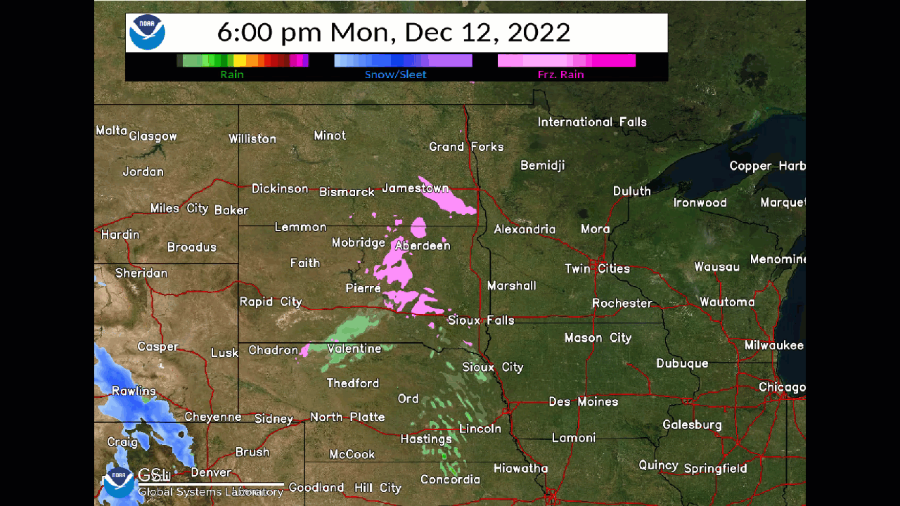
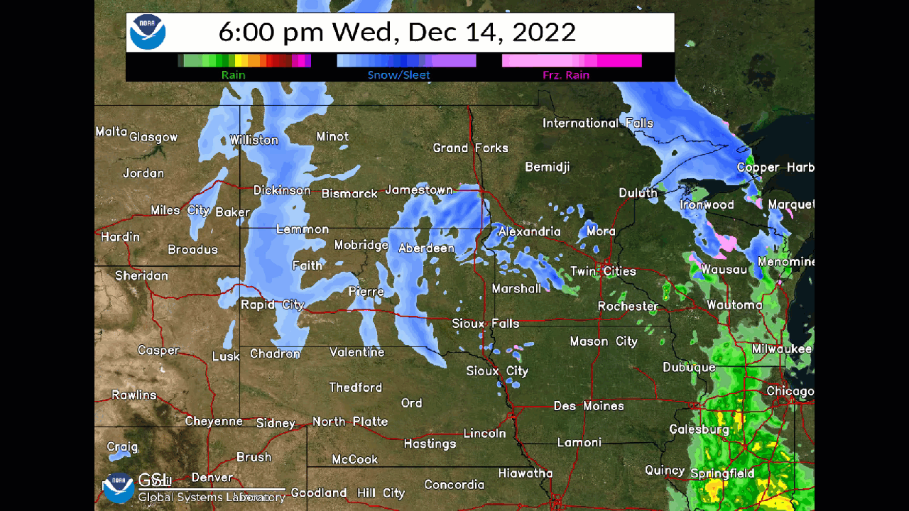
Radar Loops
 |
 |
| MRMS Radar Loop 6 PM Monday, December 12 - 6 PM Wednesday, December 14 |
MRMS Radar Loop 6 PM Wednesday, December 14 - 6 AM Friday, December 16 |
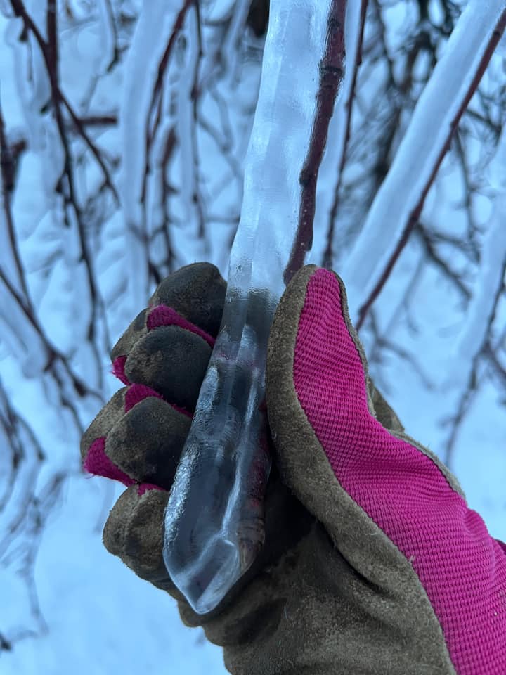
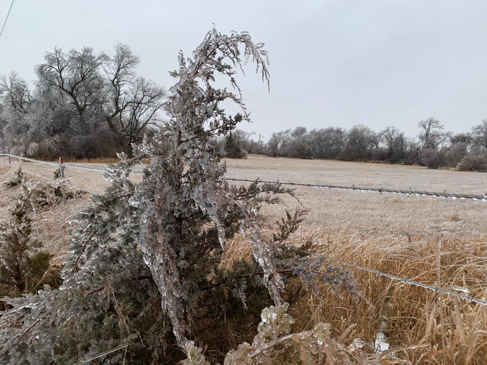
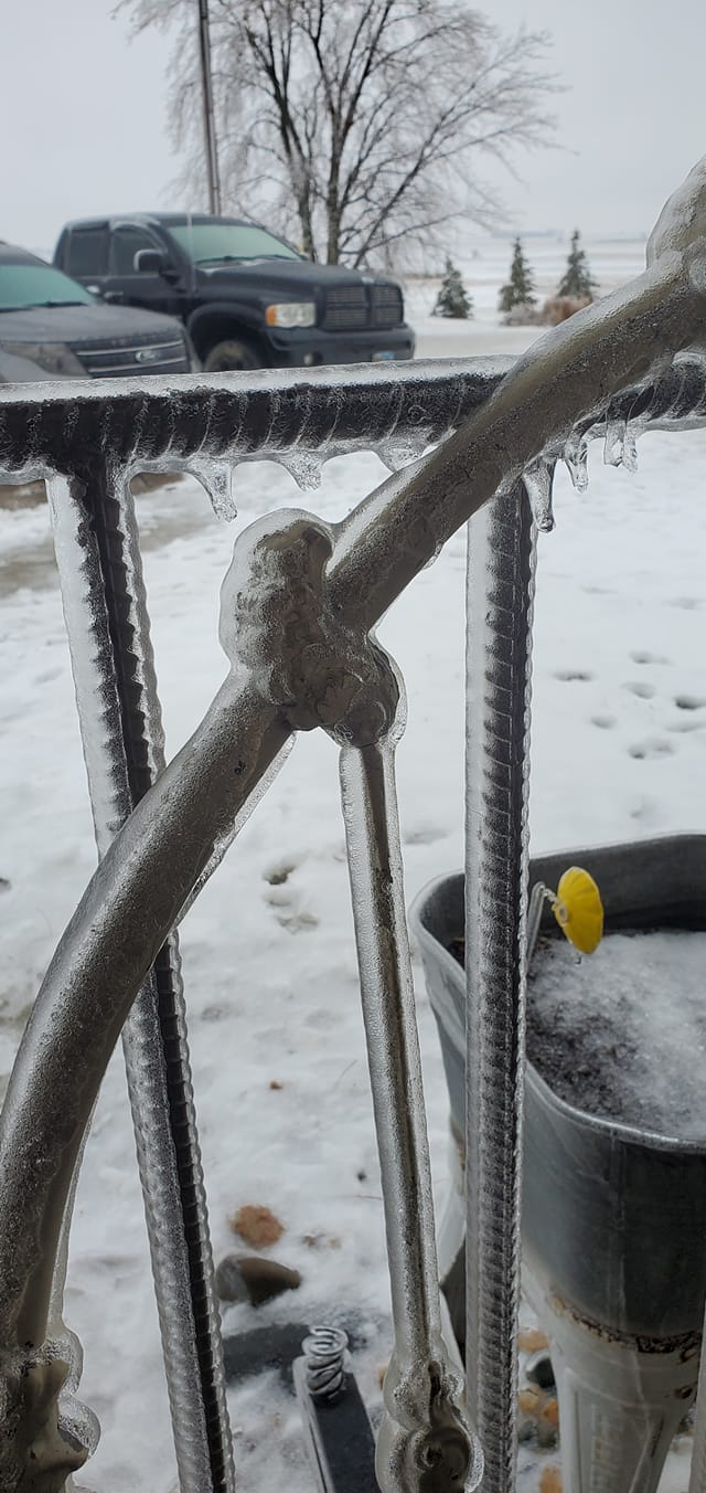
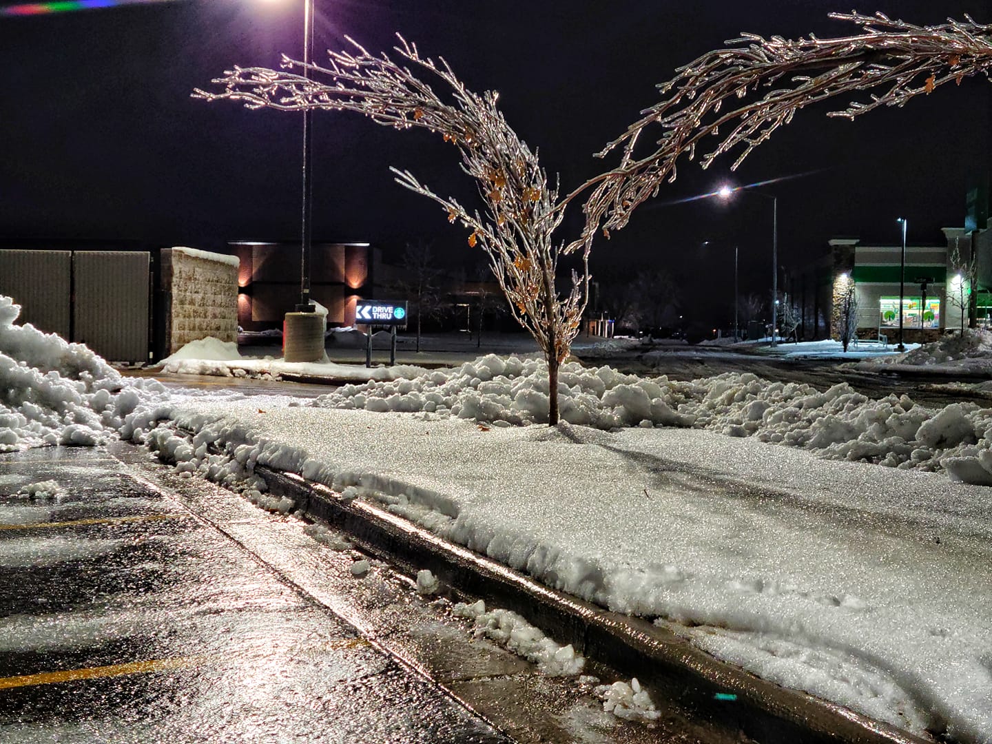
Ice Photos
 |
 |
 |
 |
| Parker, SD (photo credit: Amber Johnson) |
Bruce, SD (photo credit: Travis Koropatnicki) |
Elkton, SD (photo credit: Brittany Stein) |
West Sioux Falls, SD (photo credit: Diana Pastrana) |
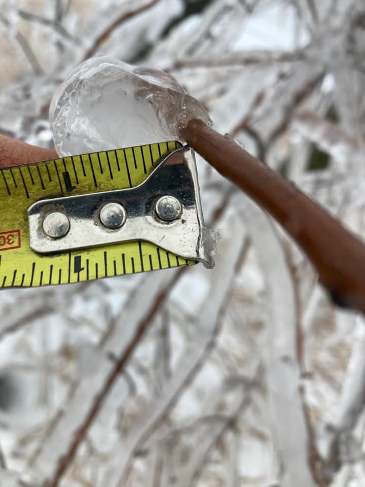
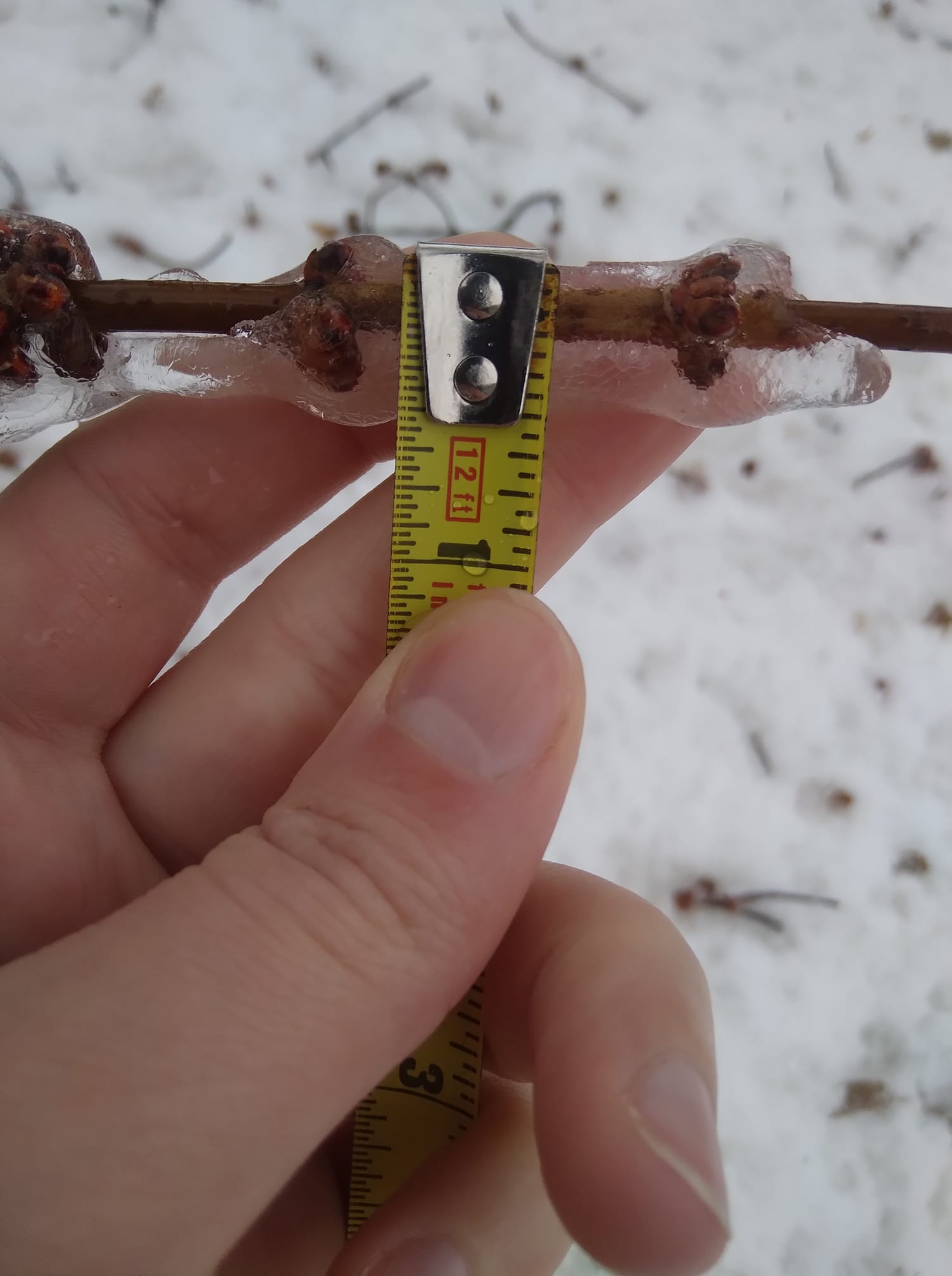
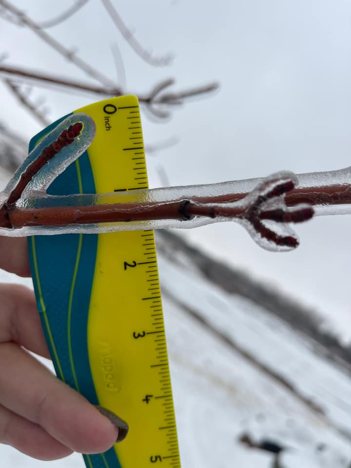
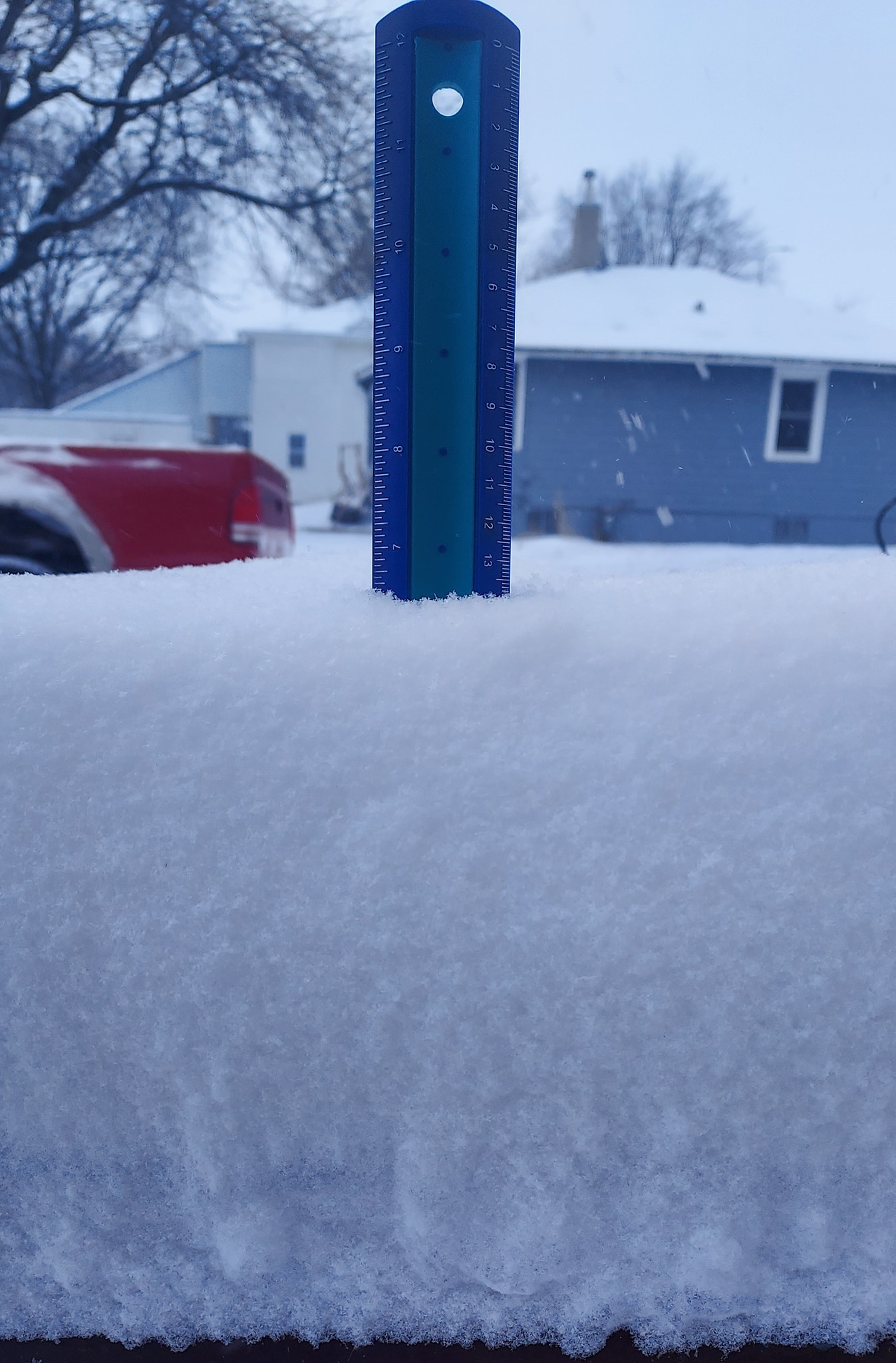
Snow and Ice Measurements
 |
 |
 |
 |
| Madison, SD (photo credit: Aaron Johnson) |
Irenton, IA (photo credit: Felicia Van Veldhuizen) |
Brookings, SD (photo credit: Robin Dunning Sorbe) |
Madison, SD (photo credit: Lisa Peters) |
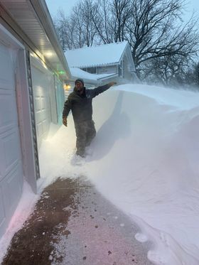
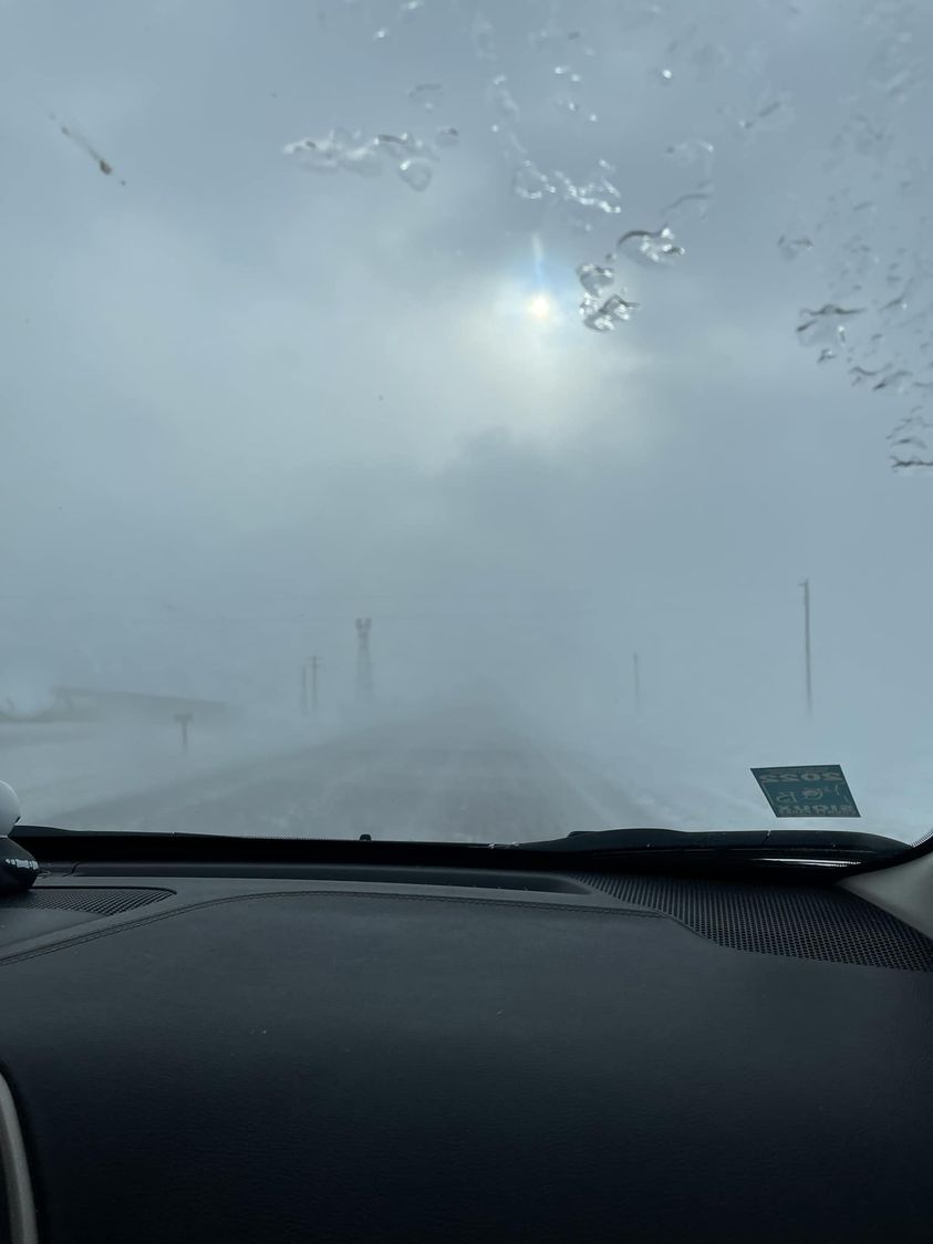
Drifting Snow
 |
 |
 |
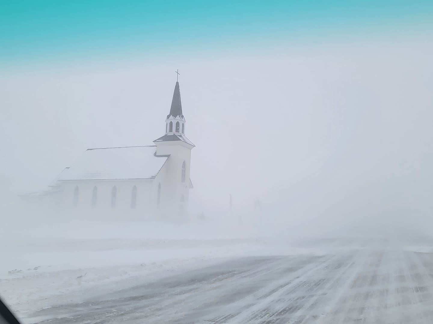 |
| Granville, IA (photo credit: Nicki Paulsen) |
Tyner, MN (photo credit: Nancyjane Huehl) |
HWY 11 between Canton & Alcester (photo credit: Amber Rose Hanzlik) | Madison, SD (photo credit: Michael Black) |
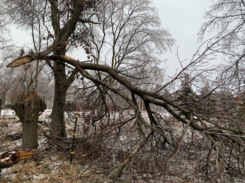
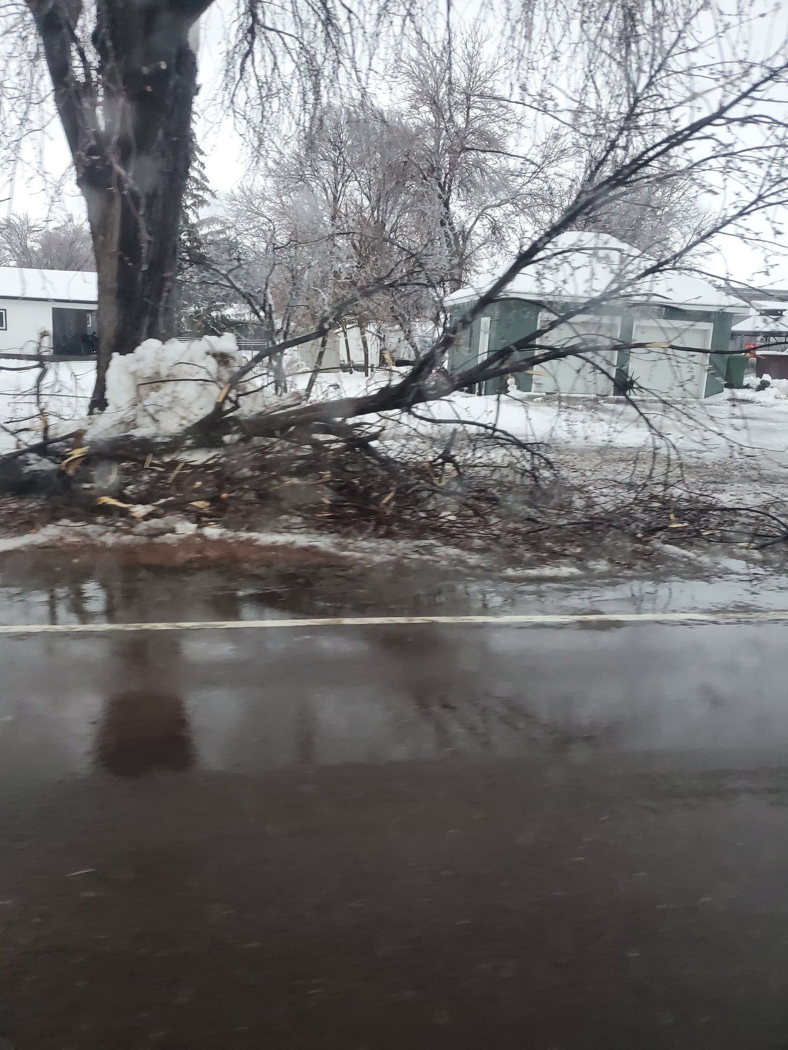
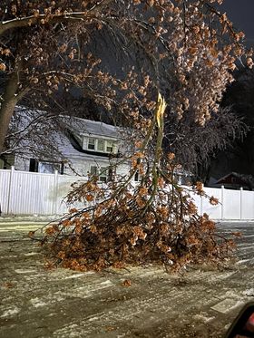
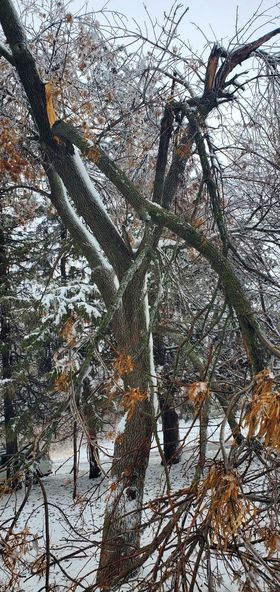
Tree Damage
 |
 |
 |
 |
| Bruce, SD (photo credit: Travis Koropatnicki) |
Larchwood, IA (photo credit: Kyle Bleeker) |
Sanborm, IA (photo credit: Dan Gottschalk) |
Melvin, IA (photo credit: Christy Year) |
 |
Media use of NWS Web News Stories is encouraged! Please acknowledge the NWS as the source of any news information accessed from this site. |
|


 Weather Story
 Weather Map
 Local Radar