Overview
|
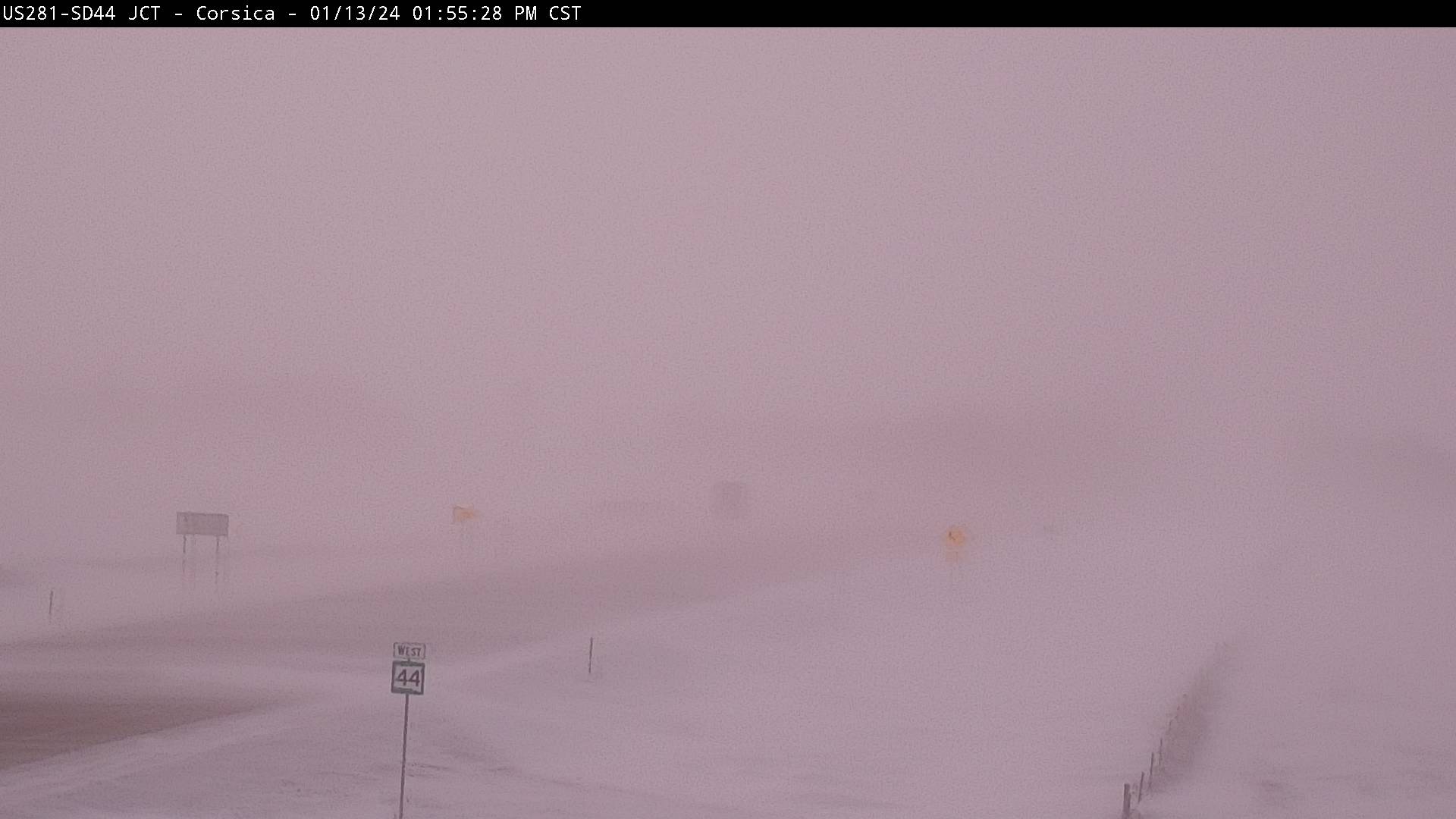
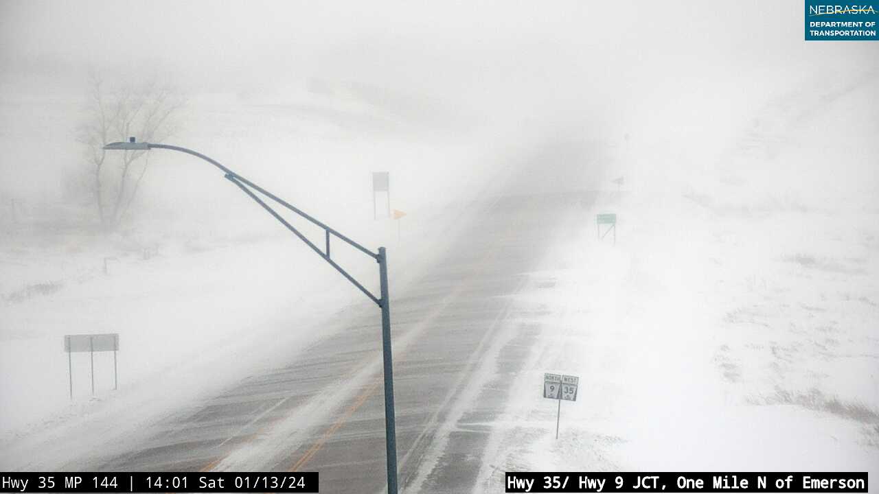
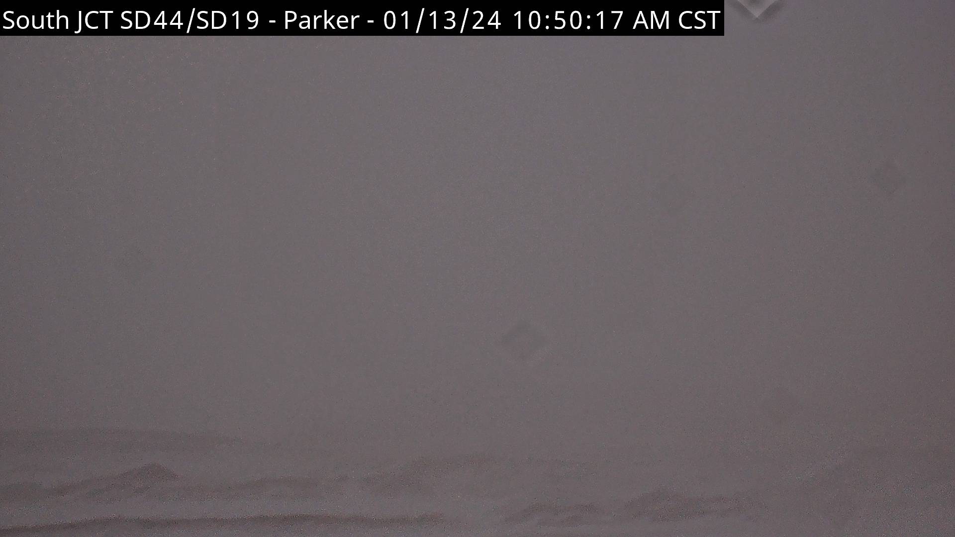
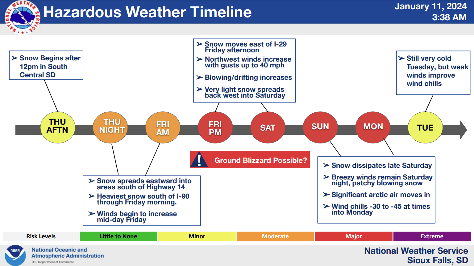
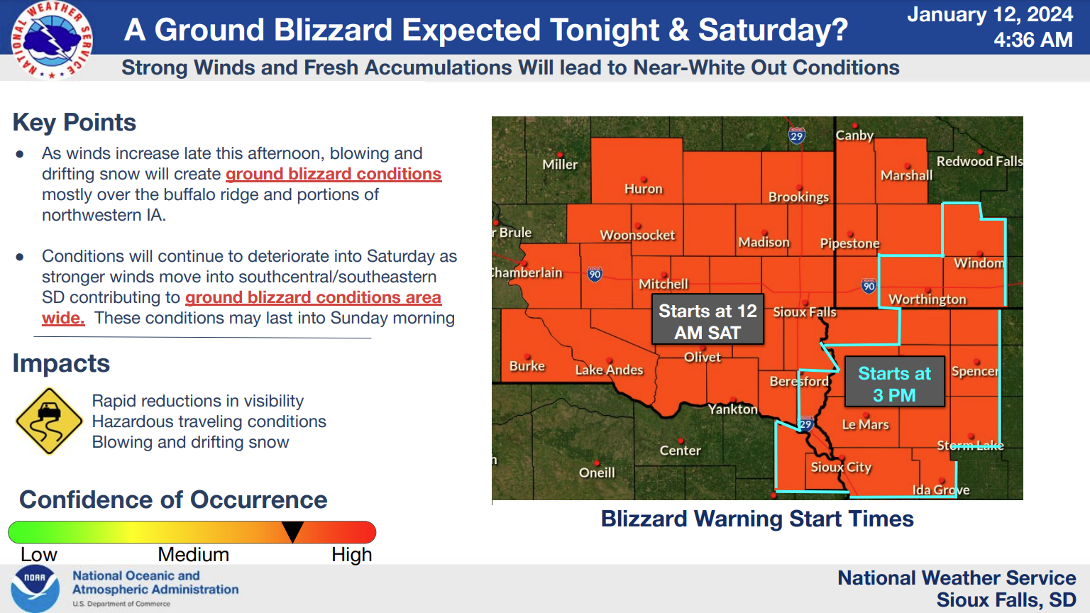
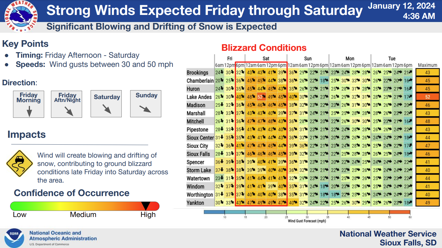
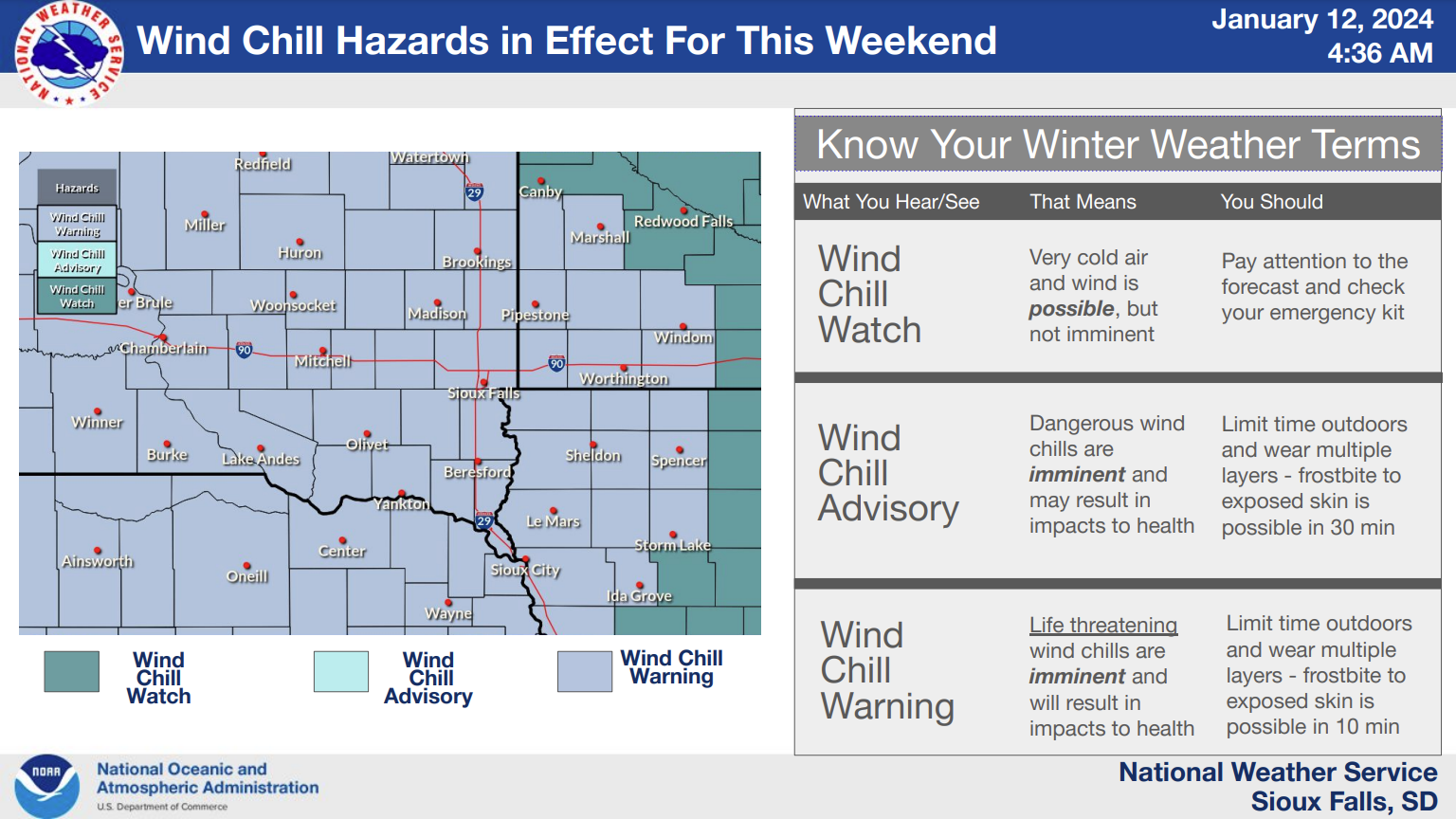
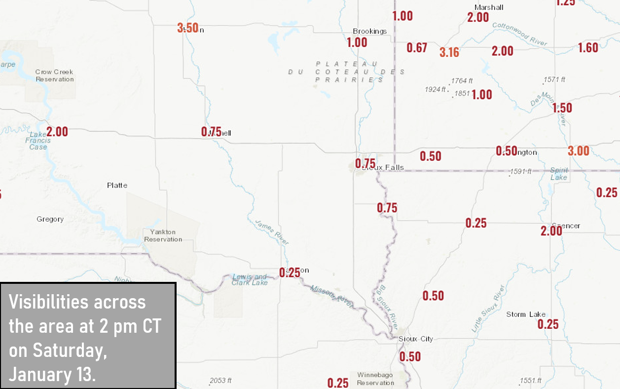
Multiple winter hazards occurred across the Northern Plains from the evening of January 11th through the morning hours of January 16th. Light to moderate snow began across the region during the afternoon and evening of January 11th before exiting the area throughout the day on January 12th. Less than an inch all the way up to 8 inches of snow was reported, highest south of I-90. Strong wind gusts moved in as the snow diminished with gusts up to 40-60 mph, which led to blowing and drifting snow. Widespread reduced visibilities from a mile to a quarter of a mile or less resulted in ground blizzard conditions for the entirety of January 13th. The worst conditions were across areas that received fresh snowfall during the previous 24 to 36 hours. During this same period of time, an Arctic airmass sank through the central United States, bringing well below average temperatures and life-threatening wind chills. Extreme cold with wind chills between -40°F and -60°F were reported. Although the ground blizzard ceased by January 14th, these dangerous wind chills continued through the morning hours of of January 16th before temperatures and wind chills warmed to non-hazardous levels. |
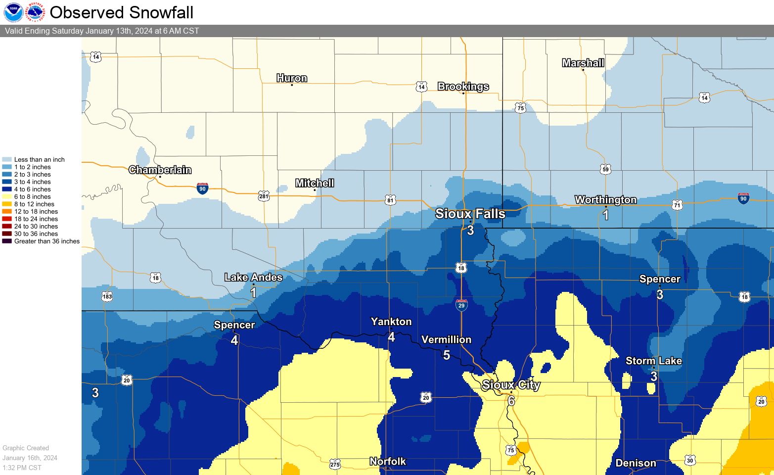 January 11-12, 2024 Snowfall |
Snowfall Reports
...SNOWFALL REPORTS JANUARY 11-13 2024...

Location                     Amount    Time/Date       Provider

...Iowa...

...Buena Vista County...
Storm Lake                   8.0 in    0800 AM 01/16   COOP

...Cherokee County...
0.9 NE Cherokee              5.3 in    0800 AM 01/16   COOP

...Dickinson County...
Spirit Lake 1.7 SW           3.0 in    0700 AM 01/15   COCORAHS
4.0 N Wahpeton               3.0 in    1200 AM 01/16   UCOOP
0.6 E Spirit Lake            4.1 in    0700 AM 01/16   COOP
Lake Park                    3.0 in    0700 AM 01/15   COOP

...Lyon County...
Rock Rapids                  3.0 in    0800 AM 01/16   COOP

...OBrien County...
Primghar                     6.0 in    0400 PM 01/15   COOP
Sanborn                      3.4 in    0800 AM 01/15   COOP
Sheldon                      5.2 in    0700 AM 01/16   COOP

...Plymouth County...
Le Mars                      6.0 in    0900 AM 01/16   COOP
Remsen                       6.0 in    0900 AM 01/16   COOP

...Woodbury County...
3.4 N Hornick                7.6 in    0700 AM 01/16   COOP
Sioux City                   6.9 in    0552 PM 01/13   Official NWS Obs

...Minnesota...

...Cottonwood County...
Windom                       0.6 in    0700 AM 01/15   COOP

...Nobles County...
Worthington 2 NNE            2.5 in    0700 AM 01/16   COOP

...Pipestone County...
Edgerton 0.2 WSW             0.4 in    0600 AM 01/15   COCORAHS

...Rock County...
Hills 0.2 NW                 1.7 in    0700 AM 01/15   COCORAHS

...Nebraska...

...Dixon County...
Newcastle                    7.2 in    0700 AM 01/15   COCORAHS
Wakefield 3 NW               5.5 in    0700 AM 01/15   COCORAHS

...South Dakota...

...Aurora County...
Stickney 3.8 SW              1.0 in    0700 AM 01/15   COCORAHS

...Beadle County...
Huron 1.3 S                  0.3 in    0730 AM 01/14   COCORAHS
Huron                        Trace     0314 AM 01/13   Official NWS Obs

...Bon Homme County...
Tyndall                      5.1 in    0800 AM 01/16   COOP

...Charles Mix County...
Academy 2 NE                 1.5 in    0900 AM 01/16   COOP

...Clay County...
Vermillion 1.4 SE            6.0 in    0600 AM 01/14   COCORAHS

...Davison County...
Mitchell                     Trace     0337 AM 01/13   Official NWS Obs

...Gregory County...
Burke 10.5 SSE               3.0 in    0700 AM 01/12   COCORAHS
Gregory                      3.0 in    0700 AM 01/15   COOP

...Hutchinson County...
Menno                        2.6 in    0600 PM 01/12   COOP
Parkston 0.1 NW              3.0 in    0800 AM 01/15   COCORAHS
Emery 10.8 S                 1.8 in    0600 AM 01/15   COCORAHS

...Lincoln County...
Harrisburg 0.8 NNE           3.4 in    0700 AM 01/13   COCORAHS
Canton                       4.2 in    0700 AM 01/14   COOP
Sioux Falls 3.6 SSE          3.3 in    0700 AM 01/14   COCORAHS

...McCook County...
Bridgewater                  2.0 in    0700 AM 01/14   COOP
Montrose                     2.0 in    0700 AM 01/14   COOP
Parker 7.2 N                 1.0 in    0700 AM 01/12   COCORAHS
Montrose 5.8 NW              0.7 in    0700 AM 01/13   COCORAHS
Salem 5NE                    0.5 in    0700 AM 01/15   COOP

...Minnehaha County...
Sioux Falls 5.0 SE ARPT      3.9 in    0700 AM 01/14   COCORAHS
Sioux Falls 3.4 ESE          2.9 in    0700 AM 01/14   COCORAHS
Sioux Falls 5.2 E            3.4 in    0700 AM 01/13   COCORAHS
Sioux Falls 3.7 WSW          3.2 in    0800 AM 01/12   COCORAHS
Hartford 6.4 S               2.5 in    0900 AM 01/15   COCORAHS
5 W Garretson                2.5 in    0700 AM 01/14   COCORAHS
NWS Sioux Falls              2.5 in    0509 AM 01/13   Official NWS Obs
Hartford 0.5 N               1.5 in    0600 AM 01/13   COCORAHS
Garretson 1.7 WSW            1.8 in    0700 AM 01/15   COCORAHS
Renner 4.1 NW                1.3 in    0700 AM 01/15   COCORAHS

...Moody County...
Colman 10.6 N                0.7 in    0700 AM 01/12   COCORAHS

...Turner County...
Hurley 0.2 S                 3.2 in    0600 AM 01/16   COCORAHS

...Yankton County...
Yankton 2 E                  4.0 in    0900 AM 01/15   COOP

Observations are collected from a variety of sources with varying
equipment and exposures. We thank all volunteer weather observers
for their dedication. Not all data listed are considered official.
Maximum Wind Gusts
...HIGHEST WIND REPORTS...

Location                     Speed     Time/Date       Provider

...Iowa...

...Buena Vista County...
Storm Lake Airport           45 MPH    0615 PM 01/13   AWOS
Storm Lake                   40 MPH    0900 PM 01/13   MESOWEST

...Cherokee County...
Marcus                       41 MPH    0915 AM 01/13   DAVIS

...Clay County...
Spencer Municipal Airport    46 MPH    0353 PM 01/12   ASOS
Webb                         25 MPH    0345 PM 01/12   DAVIS

...Dickinson County...
TERRIL                       40 MPH    1139 AM 01/13   CWOP
Milford                      38 MPH    0100 PM 01/13   CWOP
Lake Park                    37 MPH    0155 AM 01/13   CWOP
Spirit Lake                  36 MPH    0146 AM 01/13   CWOP
Wahpeton                     31 MPH    0634 PM 01/12   AWS

...Ida County...
Battle Creek                 42 MPH    0205 PM 01/12   DAVIS
Ida Grove                    29 MPH    0710 PM 01/12   MESOWEST

...Lyon County...
Larchwood                    30 MPH    1255 PM 01/13   DAVIS

...OBrien County...
Sheldon Airport              40 MPH    1235 PM 01/13   AWOS
Hartley                      33 MPH    0655 PM 01/13   DAVIS
Sutherland                   33 MPH    0135 PM 01/13   DAVIS

...Osceola County...
Sibley                       36 MPH    0835 PM 01/13   DAVIS

...Plymouth County...
Remsen                       40 MPH    1230 PM 01/13   DAVIS
Sioux City                   40 MPH    0955 AM 01/13   DAVIS
Le Mars Airport              39 MPH    0815 AM 01/13   AWOS
Loess Hills Tnc Broken       33 MPH    0111 PM 01/13   RAWS
Remsen                       31 MPH    1005 AM 01/13   DAVIS

...Sioux County...
1 NE Maurice                 45 MPH    1035 AM 01/13   AWOS
Sioux County Regional Airpor 45 MPH    1035 AM 01/13   MESOWEST
Hawarden                     40 MPH    1015 AM 01/13   CWOP
Alton                        38 MPH    0320 PM 01/13   MESOWEST
Sioux Center                 25 MPH    0915 AM 01/13   CWOP
Hull                         23 MPH    1000 AM 01/16   DAVIS

...Woodbury County...
Sioux Gateway Airport        49 MPH    0905 AM 01/13   ASOS
Moville                      39 MPH    0110 PM 01/13   MESOWEST
Danbury                      24 MPH    0900 PM 01/13   DAVIS
3.2 S Correctionville (SCAN) 20 MPH    1200 PM 01/13   MESOWEST

...Minnesota...

...Cottonwood County...
T.h.60 - Mountain Lake - Mp  46 MPH    0115 AM 01/13   MESOWEST
T.h.71 - Jeffers - Mp 43     43 MPH    0245 AM 01/13   MESOWEST
Windom Municipal Airport     43 MPH    1255 AM 01/13   AWOS
Westbrook                    23 MPH    0255 AM 01/13   DAVIS

...Jackson County...
Jackson Airport              46 MPH    0215 AM 01/13   AWOS
I-90 - Lakefield - Mp 67     44 MPH    0315 AM 01/13   MESOWEST
Lakefield                    36 MPH    0228 AM 01/13   CWOP
Brewster                     26 MPH    0135 PM 01/13   DAVIS
6 NW Orleans                 25 MPH    0440 PM 01/12   AWS

...Lincoln County...
U.S.14 - Lake Benton - Mp 7  42 MPH    1035 AM 01/13   MESOWEST
Ivanhoe                      37 MPH    1115 PM 01/12   CWOP
T.h.19 - Hendricks - Mp 2    36 MPH    1115 AM 01/13   MESOWEST

...Lyon County...
U.S.14 - Florence - Mp 21.2  48 MPH    1230 AM 01/13   MESOWEST
T.h.68 - Taunton - Mp 22.9   43 MPH    1255 AM 01/13   MESOWEST
Tracy Airport                43 MPH    1235 AM 01/13   AWOS
Balaton                      40 MPH    0530 AM 01/13   DAVIS
Marshall Municipal Airport   40 MPH    1232 AM 01/13   AWOS

...Murray County...
T.h.30 - Dovray - Mp 49      40 MPH    0250 PM 01/12   MESOWEST
Slayton Municipal Airport    38 MPH    1133 AM 01/13   AWOS

...Nobles County...
I-90 - Rushmore - Mp 35      42 MPH    1000 AM 01/13   MESOWEST
Worthington Airport          39 MPH    1105 AM 01/13   AWOS
Reading                      32 MPH    1125 AM 01/13   DAVIS

...Pipestone County...
U.S.75 - Trosky - Mp 30.3    46 MPH    0110 PM 01/13   MESOWEST
Redstone RAWS                36 MPH    0121 PM 01/13   RAWS

...Rock County...
Luverne                      48 MPH    0200 PM 01/13   DAVIS
I-90 - Beaver Creek Mp 4     44 MPH    0110 PM 01/13   MESOWEST
I-90 - Magnolia - Mp 21.6    44 MPH    1050 AM 01/13   MESOWEST
Luverne Airport              41 MPH    0215 PM 01/13   AWOS
Hardwick                     38 MPH    0225 PM 01/13   DAVIS

...Nebraska...

...Dakota County...
South Sioux City             40 MPH    1000 AM 01/13   CWOP

...Dixon County...
Concord 2E                   40 MPH    0135 PM 01/13   NE-MESO
Ponca                        30 MPH    0845 AM 01/13   DAVIS

...South Dakota...

...Aurora County...
SD RWIS Plankinton           50 MPH    1150 AM 01/13   SDDOT
White Lake (SD Mesonet)      46 MPH    0645 AM 01/13   SDSMESO

...Beadle County...
Huron Regional Airport       45 MPH    0822 AM 01/13   ASOS
SD RWIS Wolsey               45 MPH    1143 AM 01/13   SDDOT
SD RWIS Cavour               44 MPH    1058 AM 01/13   SDDOT

...Bon Homme County...
SD RWIS Tyndall              48 MPH    0834 AM 01/13   SDDOT
Scotland                     39 MPH    1115 AM 01/13   DAVIS

...Brookings County...
Brookings Municipal Airport  38 MPH    0957 AM 01/13   AWOS
Volga (SD Mesonet)           37 MPH    0150 PM 01/13   SDSMESO
Brookings 2NE                36 MPH    1015 AM 01/13   SDSMESO
Astoria 4 SSE (SD Mesonet)   33 MPH    0710 PM 01/15   SDSMESO
Elkton                       33 MPH    1115 AM 01/13   CWOP
Brookings                    30 MPH    1035 AM 01/13   DAVIS
Aurora 2NNE                  26 MPH    1120 AM 01/13   SDSMESO
White                        26 MPH    0515 AM 01/13   DAVIS
Elkton                       24 MPH    0100 AM 01/13   CWOP

...Brule County...
SD RWIS Kimball              51 MPH    0807 AM 01/13   SDDOT
Chamberlain Municipal Airpor 39 MPH    1215 PM 01/13   ASOS

...Charles Mix County...
SD RWIS Platte-Winner Bridge 59 MPH    1114 AM 01/13   SDDOT
SD RWIS WAGNER               51 MPH    0918 AM 01/13   SDDOT
Lake Andes RAWS              46 MPH    0141 PM 01/13   RAWS
Delmont                      37 MPH    0925 AM 01/13   DAVIS
Wagner                       35 MPH    0725 AM 01/13   DAVIS
Platte                       28 MPH    0345 PM 01/15   CWOP

...Clay County...
Beresford 7 WSW (SD Mesonet) 41 MPH    1000 AM 01/13   SDSMESO
Vermillion                   37 MPH    0555 AM 01/13   AWOS
Wakonda                      30 MPH    0945 AM 01/13   DAVIS

...Davison County...
Mitchell Municipal Airport   44 MPH    0916 AM 01/13   ASOS
Ethan                        27 MPH    1234 PM 01/13   AWS

...Douglas County...
SD RWIS Corsica              51 MPH    0928 AM 01/13   SDDOT
Armour                       35 MPH    0200 PM 01/13   DAVIS
Corsica                      35 MPH    0935 AM 01/13   DAVIS
Armour                       26 MPH    0640 AM 01/13   DAVIS

...Gregory County...
SD RWIS Ft. Randall Dam      61 MPH    0743 AM 01/13   SDDOT
SD RWIS Dallas               53 MPH    0838 AM 01/13   SDDOT
SD RWIS Dixon                50 MPH    0706 AM 01/13   SDDOT
Bonesteel                    41 MPH    1135 AM 01/13   DAVIS
Gregory                      40 MPH    0355 PM 01/15   AWOS
Herrick                      40 MPH    0225 AM 01/13   DAVIS
Butte 8NNW                   37 MPH    0800 AM 01/13   CWOP
2 N Bonesteel                28 MPH    1130 AM 01/13   AWS

...Hanson County...
SD RWIS Alexandria           47 MPH    0506 AM 01/13   SDDOT

...Hutchinson County...
SD RWIS Freeman              50 MPH    0909 AM 01/13   SDDOT
SD RWIS Tripp                50 MPH    0809 AM 01/13   SDDOT
Parkston (SD Mesonet)        39 MPH    1220 PM 01/13   SDSMESO
Ethan                        33 MPH    0215 PM 01/15   DAVIS

...Jerauld County...
SD RWIS Lane                 47 MPH    1207 AM 01/16   SDDOT
2 ESE Wessington Springs     46 MPH    0255 PM 01/15   AWOS

...Kingsbury County...
SD RWIS Arlington            43 MPH    1248 PM 01/13   SDDOT
Iroquois                     33 MPH    0915 AM 01/13   DAVIS
Erwin                        28 MPH    0325 AM 01/13   DAVIS

...Lake County...
Ramona                       27 MPH    0700 PM 01/13   DAVIS
Wentworth                    27 MPH    1135 PM 01/12   DAVIS

...Lincoln County...
Harrisburg                   50 MPH    1205 PM 01/13   CWOP
SD RWIS Davis                50 MPH    0947 AM 01/13   SDDOT
Canton                       38 MPH    0855 AM 01/13   AWOS
Tea                          29 MPH    1255 PM 01/13   AWOS

...McCook County...
SD RWIS Montrose             50 MPH    0848 AM 01/13   SDDOT
SD RWIS STANLEY CORNER       44 MPH    0522 AM 01/13   SDDOT
Canova                       43 MPH    0935 AM 01/13   CWOP
Montrose                     37 MPH    1145 AM 01/13   DAVIS
Salem                        26 MPH    1035 AM 01/13   DAVIS
Bridgewater                  22 MPH    0405 PM 01/12   DAVIS

...Miner County...
SD RWIS Howard               43 MPH    0839 AM 01/13   SDDOT
Winfred                      34 MPH    1115 AM 01/13   DAVIS

...Minnehaha County...
Sioux Falls Airport          48 MPH    1057 AM 01/13   ASOS
SD RWIS Dell Rapids          47 MPH    1114 AM 01/13   SDDOT
Sioux Falls 10 WSW (SD Meson 42 MPH    1105 AM 01/13   SDSMESO
Baltic 3 SE (SD Mesonet)     40 MPH    1030 AM 01/13   SDSMESO
Colton 2 ESE (SD Mesonet)    36 MPH    1015 AM 01/13   SDSMESO
Sioux Falls (SD Mesonet)     33 MPH    1240 PM 01/13   SDSMESO
Eros Data Center             30 MPH    1200 PM 01/13   MESOWEST
Brandon                      25 MPH    0650 AM 01/13   DAVIS

...Moody County...
SD RWIS Ward                 45 MPH    0953 AM 01/13   SDDOT
Flandreau 3 NNE (SD Mesonet) 39 MPH    1155 AM 01/13   SDSMESO
Colman                       35 MPH    0705 AM 01/13   DAVIS

...Sanborn County...
SD RWIS Forestburg           42 MPH    0740 AM 01/13   SDDOT
Letcher 2ENE                 41 MPH    1045 AM 01/13   SDSMESO

...Turner County...
SD RWIS Parker               49 MPH    0943 AM 01/13   SDDOT
SD RWIS IRENE                48 MPH    0932 AM 01/13   SDDOT
Marion                       31 MPH    0855 AM 01/13   DAVIS
Chancellor                   25 MPH    0435 AM 01/13   DAVIS
1 S Centerville              22 MPH    1205 PM 01/13   AWS

...Union County...
SD RWIS Beresford            46 MPH    1025 AM 01/13   SDDOT
SD RWIS North Sioux City     44 MPH    0853 AM 01/13   SDDOT

...Yankton County...
Yankton Municipal Airport    47 MPH    0823 AM 01/13   AWOS
SD RWIS Gayville             46 MPH    0833 AM 01/13   SDDOT

Observations are collected from a variety of sources with varying
equipment and exposures. We thank all volunteer weather observers
for their dedication. Not all data listed are considered official.
Minimum Wind Chill
...MINIMUM WIND CHILL REPORTS...

Location                     WC Temp.  Time/Date       Provider

...Iowa...

...Buena Vista County...
Storm Lake Airport           -51 F     0215 AM 01/14   AWOS

...Cherokee County...
Marcus                       -52 F     0715 PM 01/13   DAVIS

...Clay County...
Spencer Municipal Airport    -47 F     0653 PM 01/13   ASOS
Webb                         -41 F     0825 PM 01/13   DAVIS

...Dickinson County...
Terril                       -51 F     0759 PM 01/13   CWOP
Milford                      -49 F     1230 AM 01/14   CWOP
Lake Park                    -46 F     0120 AM 01/14   CWOP
Spirit Lake                  -46 F     0731 PM 01/13   CWOP
Wahpeton                     -42 F     1059 PM 01/13   AWS

...Ida County...
Battle Creek                 -49 F     0315 AM 01/14   DAVIS
Ida Grove                    -42 F     1005 PM 01/13   MESOWEST

...Lyon County...
Larchwood                    -49 F     0955 PM 01/13   DAVIS
4 SW George                  -38 F     0220 AM 01/14   AWS
Inwood                       -31 F     0935 AM 01/14   DAVIS

...OBrien County...
Hartley                      -53 F     0655 PM 01/13   DAVIS
Sutherland                   -51 F     0705 PM 01/13   DAVIS
Sheldon Airport              -49 F     1155 PM 01/13   AWOS

...Osceola County...
Sibley                       -55 F     0835 PM 01/13   DAVIS

...Plymouth County...
Remsen                       -50 F     1255 AM 01/14   DAVIS
Le Mars                      -40 F     1216 AM 01/14   CWOP
Loess Hills Tnc Broken       -39 F     0211 AM 01/14   RAWS

...Sioux County...
1 NE Maurice                 -51 F     0855 PM 01/13   AWOS
Sioux County Regional Airpor -51 F     0855 PM 01/13   MESOWEST
Hawarden                     -50 F     1245 AM 01/14   DAVIS
Alton                        -47 F     1200 AM 01/14   MESOWEST
Hull                         -46 F     0601 PM 01/13   DAVIS

...Woodbury County...
Danbury                      -45 F     0900 PM 01/13   DAVIS
Sioux Gateway Airport        -44 F     0152 AM 01/14   ASOS
3.2 S Correctionville (SCAN) -42 F     1200 AM 01/14   MESOWEST
Moville                      -41 F     1235 AM 01/14   MESOWEST
1 ENE Dakota City            -38 F     0756 AM 01/14   AWS

...Minnesota...

...Cottonwood County...
T.h.71 - Jeffers - Mp 43     -49 F     1210 AM 01/14   MESOWEST
Windom Municipal Airport     -47 F     0115 AM 01/14   AWOS
T.h.60 - Mountain Lake - Mp  -47 F     1215 AM 01/14   MESOWEST
Westbrook                    -44 F     0710 PM 01/13   DAVIS

...Jackson County...
I-90 - Lakefield - Mp 67     -50 F     1145 PM 01/13   MESOWEST
Brewster                     -48 F     0855 PM 01/13   DAVIS
Jackson Airport              -46 F     1235 AM 01/14   AWOS
6 NW Orleans                 -43 F     0110 AM 01/14   AWS
Lakefield                    -40 F     1151 PM 01/13   CWOP

...Lincoln County...
U.S.14 - Lake Benton - Mp 7  -56 F     0835 PM 01/13   MESOWEST
T.h.19 - Hendricks - Mp 2    -52 F     1030 PM 01/13   MESOWEST
Ivanhoe                      -50 F     1006 PM 01/13   CWOP

...Lyon County...
U.S.14 - Florence - Mp 21.2  -54 F     1045 PM 01/13   MESOWEST
Balaton                      -51 F     1005 PM 01/13   DAVIS
Tracy Airport                -47 F     1055 PM 01/13   AWOS
Marshall Municipal Airport   -45 F     1056 PM 01/13   AWOS
T.h.68 - Taunton - Mp 22.9   -44 F     1130 PM 01/13   MESOWEST

...Murray County...
Slayton Municipal Airport    -51 F     0913 PM 01/13   AWOS
T.h.30 - Dovray - Mp 49      -51 F     0920 PM 01/13   MESOWEST

...Nobles County...
I-90 - Rushmore - Mp 35      -56 F     1235 AM 01/14   MESOWEST
Reading                      -52 F     0735 PM 01/13   DAVIS
Worthington Airport          -52 F     1256 AM 01/14   AWOS
Bigelow                      -42 F     1055 PM 01/13   DAVIS

...Pipestone County...
U.S.75 - Trosky - Mp 30.3    -54 F     1245 AM 01/14   MESOWEST
Redstone RAWS                -48 F     1021 PM 01/13   RAWS

...Rock County...
Hardwick                     -54 F     0605 PM 01/13   DAVIS
I-90 - Magnolia - Mp 21.6    -53 F     0920 PM 01/13   MESOWEST
I-90 - Beaver Creek Mp 4     -51 F     0550 PM 01/13   MESOWEST
Luverne Airport              -48 F     0915 PM 01/13   AWOS

...Nebraska...

...Dakota County...
South Sioux City             -40 F     0645 AM 01/14   CWOP

...Dixon County...
Concord 2E                   -48 F     0600 PM 01/13   NE-MESO
Ponca                        -44 F     0805 AM 01/14   DAVIS

...South Dakota...

...Aurora County...
SD RWIS Plankinton           -56 F     1140 AM 01/13   SDDOT
White Lake (SD Mesonet)      -54 F     1205 PM 01/13   SDSMESO

...Beadle County...
SD RWIS Wolsey               -58 F     1113 AM 01/13   SDDOT
SD RWIS Cavour               -53 F     1153 AM 01/13   SDDOT
Huron Regional Airport       -51 F     1220 PM 01/13   ASOS

...Bon Homme County...
SD RWIS Tyndall              -49 F     0215 PM 01/13   SDDOT
Scotland                     -49 F     0355 PM 01/13   DAVIS

...Brookings County...
Brookings Municipal Airport  -53 F     0856 PM 01/13   AWOS
Astoria 4 SSE (SD Mesonet)   -53 F     0920 PM 01/13   SDSMESO
Volga (SD Mesonet)           -51 F     1035 PM 01/13   SDSMESO
White                        -50 F     0735 PM 01/13   DAVIS
Elkton                       -44 F     0945 PM 01/13   CWOP
Astoria                      -39 F     0305 PM 01/13   DAVIS
Toronto                      -38 F     1000 PM 01/13   DAVIS
Aurora 2NNE                  -37 F     0855 PM 01/13   SDSMESO

...Brule County...
SD RWIS Kimball              -52 F     1149 AM 01/13   SDDOT
Chamberlain Municipal Airpor -52 F     1215 PM 01/13   ASOS

...Charles Mix County...
SD RWIS Platte-Winner Bridge -55 F     1144 AM 01/13   SDDOT
SD RWIS WAGNER               -55 F     0219 PM 01/13   SDDOT
Delmont                      -50 F     0125 PM 01/13   DAVIS
Wagner                       -49 F     0230 PM 01/13   DAVIS
Lake Andes RAWS              -49 F     0141 PM 01/13   RAWS
Platte                       -45 F     1045 AM 01/13   DAVIS

...Clay County...
Beresford 7 WSW (SD Mesonet) -46 F     0200 AM 01/14   SDSMESO
Vermillion                   -45 F     0619 PM 01/13   AWOS
Wakonda                      -42 F     0155 AM 01/14   DAVIS

...Davison County...
Ethan                        -52 F     1234 PM 01/13   AWS
Mitchell Municipal Airport   -47 F     1153 AM 01/13   ASOS

...Douglas County...
SD RWIS Corsica              -54 F     0204 PM 01/13   SDDOT
Armour                       -52 F     0200 PM 01/13   DAVIS
Corsica                      -50 F     0135 PM 01/13   DAVIS

...Gregory County...
SD RWIS Dallas               -59 F     1203 PM 01/13   SDDOT
SD RWIS Dixon                -58 F     1209 PM 01/13   SDDOT
Bonesteel                    -57 F     1135 AM 01/13   DAVIS
Herrick                      -55 F     1225 PM 01/13   DAVIS
2 N Bonesteel                -54 F     1130 AM 01/13   AWS
Gregory                      -52 F     1155 AM 01/13   AWOS
SD RWIS Ft. Randall Dam      -51 F     1246 PM 01/13   SDDOT
Butte 8NNW                   -47 F     1215 PM 01/13   CWOP

...Hanson County...
SD RWIS Alexandria           -52 F     0104 PM 01/13   SDDOT

...Hutchinson County...
SD RWIS Freeman              -53 F     0340 PM 01/13   SDDOT
SD RWIS Tripp                -53 F     0133 PM 01/13   SDDOT
Ethan                        -48 F     1225 PM 01/13   DAVIS
Parkston (SD Mesonet)        -48 F     1150 AM 01/13   SDSMESO

...Jerauld County...
SD RWIS Lane                 -55 F     1027 AM 01/13   SDDOT
2 ESE Wessington Springs     -53 F     1155 AM 01/13   AWOS

...Kingsbury County...
Erwin                        -53 F     0425 PM 01/13   DAVIS
SD RWIS Arlington            -52 F     0609 PM 01/13   SDDOT
Iroquois                     -52 F     0615 PM 01/13   DAVIS

...Lake County...
Ramona                       -53 F     0700 PM 01/13   DAVIS
Wentworth                    -49 F     0945 PM 01/13   DAVIS
Winfred                      -39 F     1055 AM 01/13   DAVIS

...Lincoln County...
SD RWIS Davis                -52 F     1243 PM 01/13   SDDOT
Harrisburg                   -50 F     0837 PM 01/13   CWOP
Canton                       -47 F     0915 PM 01/13   AWOS
Tea                          -42 F     1055 PM 01/13   AWOS

...McCook County...
SD RWIS Montrose             -54 F     0745 PM 01/13   SDDOT
Canova                       -51 F     1005 PM 01/13   DAVIS
Salem                        -50 F     0645 PM 01/13   DAVIS
SD RWIS STANLEY CORNER       -46 F     0215 PM 01/13   SDDOT
Bridgewater                  -40 F     0455 PM 01/13   DAVIS

...Miner County...
Winfred                      -53 F     1015 PM 01/13   DAVIS
SD RWIS Howard               -51 F     0541 PM 01/13   SDDOT

...Minnehaha County...
SD RWIS Dell Rapids          -54 F     0821 PM 01/13   SDDOT
Colton 2 ESE (SD Mesonet)    -51 F     0900 PM 01/13   SDSMESO
EROS Data Center             -50 F     1100 PM 01/13   MESOWEST
Sioux Falls 10 WSW (SD Meson -50 F     0900 PM 01/13   SDSMESO
Baltic 3 SE (SD Mesonet)     -47 F     0830 PM 01/13   SDSMESO
Sioux Falls Airport          -47 F     0946 PM 01/13   ASOS
Baltic                       -44 F     0535 PM 01/13   DAVIS
Brandon                      -44 F     0605 PM 01/13   DAVIS
5 SSE Baltic                 -38 F     1005 PM 01/13   AWS

...Moody County...
SD RWIS Ward                 -54 F     1030 PM 01/13   SDDOT
Colman                       -52 F     1055 PM 01/13   DAVIS
Flandreau 3 NNE (SD Mesonet) -52 F     0615 PM 01/13   SDSMESO

...Sanborn County...
Letcher 2ENE                 -49 F     0135 PM 01/13   SDSMESO
SD RWIS Forestburg           -48 F     0454 PM 01/13   SDDOT

...Turner County...
SD RWIS Parker               -50 F     0835 PM 01/13   SDDOT
Marion                       -49 F     0335 PM 01/13   DAVIS
SD RWIS IRENE                -48 F     0759 PM 01/13   SDDOT
1 S Centerville              -43 F     0720 PM 01/13   AWS
Chancellor                   -41 F     0615 PM 01/13   DAVIS

...Union County...
SD RWIS Beresford            -51 F     0621 PM 01/13   SDDOT
SD RWIS North Sioux City     -45 F     0309 PM 01/13   SDDOT

...Yankton County...
SD RWIS Gayville             -47 F     0454 PM 01/13   SDDOT
Yankton Municipal Airport    -46 F     0239 PM 01/13   AWOS

Observations are collected from a variety of sources with varying
equipment and exposures. We thank all volunteer weather observers
for their dedication. Not all data listed are considered official.
Photos & Video
Header
 |
 |
 |
 |
| Corsica DOT Webcam (SDDOT) |
Emerson DOT Webcam (NEDOT) |
Parker DOT Webcam (SDDOT) |
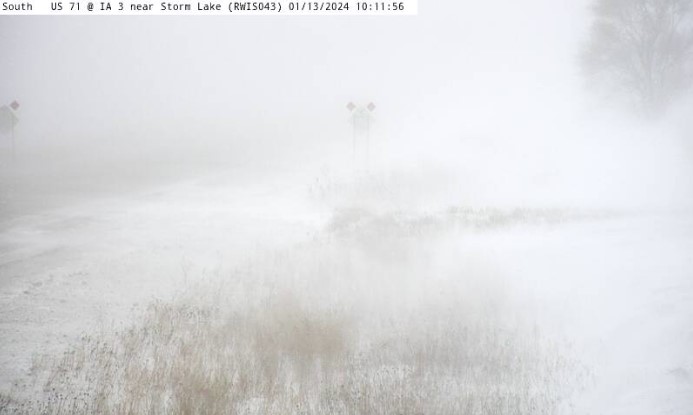
Storm Lake DOT Webcam (IADOT) |
Radar
.gif) |
.gif) |
.gif) |
.gif) |
.gif) |
| Radar loop from noon to 6 pm on January 11th. | Radar loop from 6 pm to midnight on January 11th. | Radar loop from midnight to 6 am on January 12th. | Radar loop from 6 am to noon on January 12th. | Radar loop from noon to 6pm on January 12th. |
Decision Support Forecast Information
 |
Media use of NWS Web News Stories is encouraged! Please acknowledge the NWS as the source of any news information accessed from this site. |
|


 Weather Story
 Weather Map
 Local Radar