Overview
|
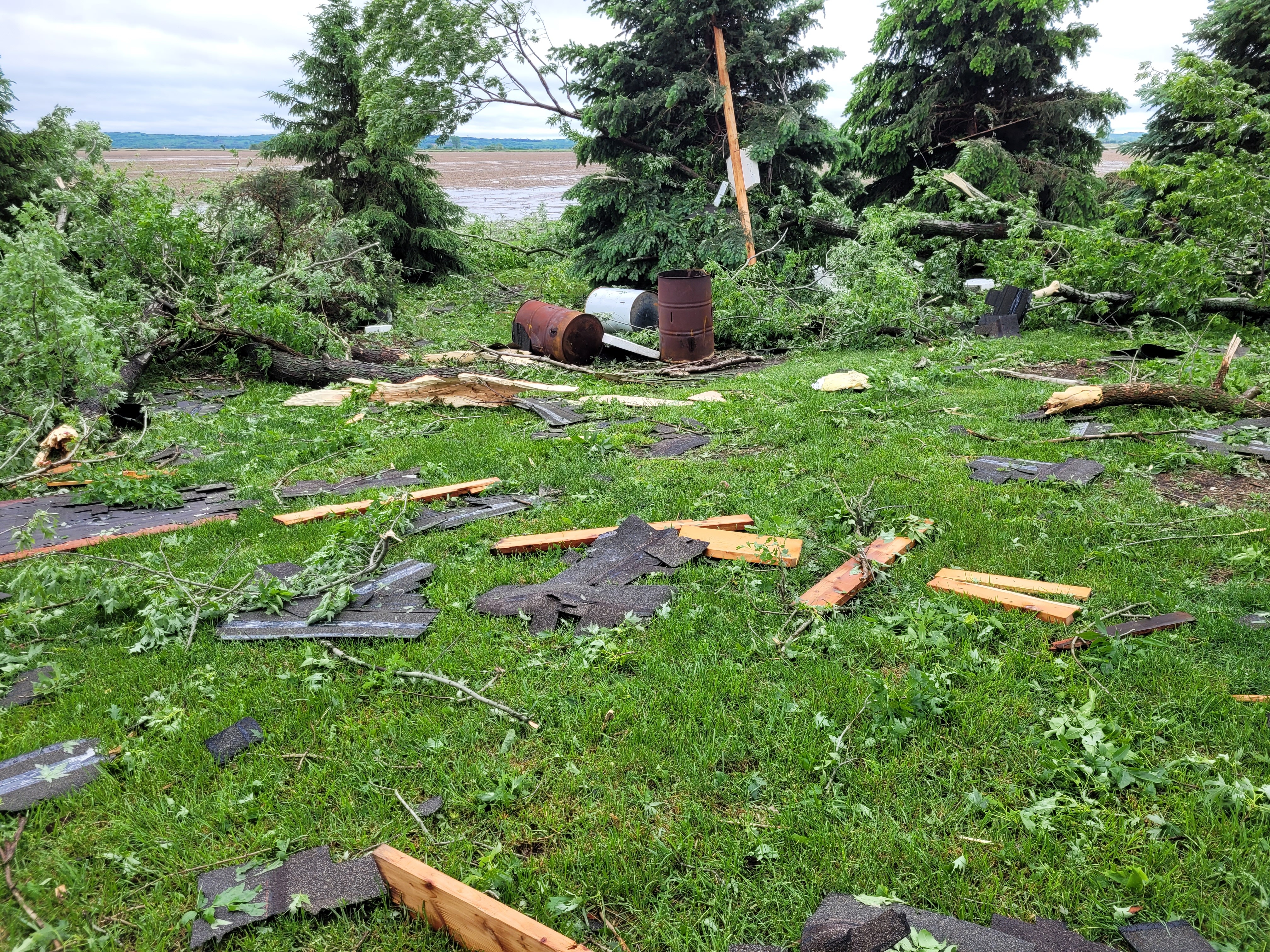
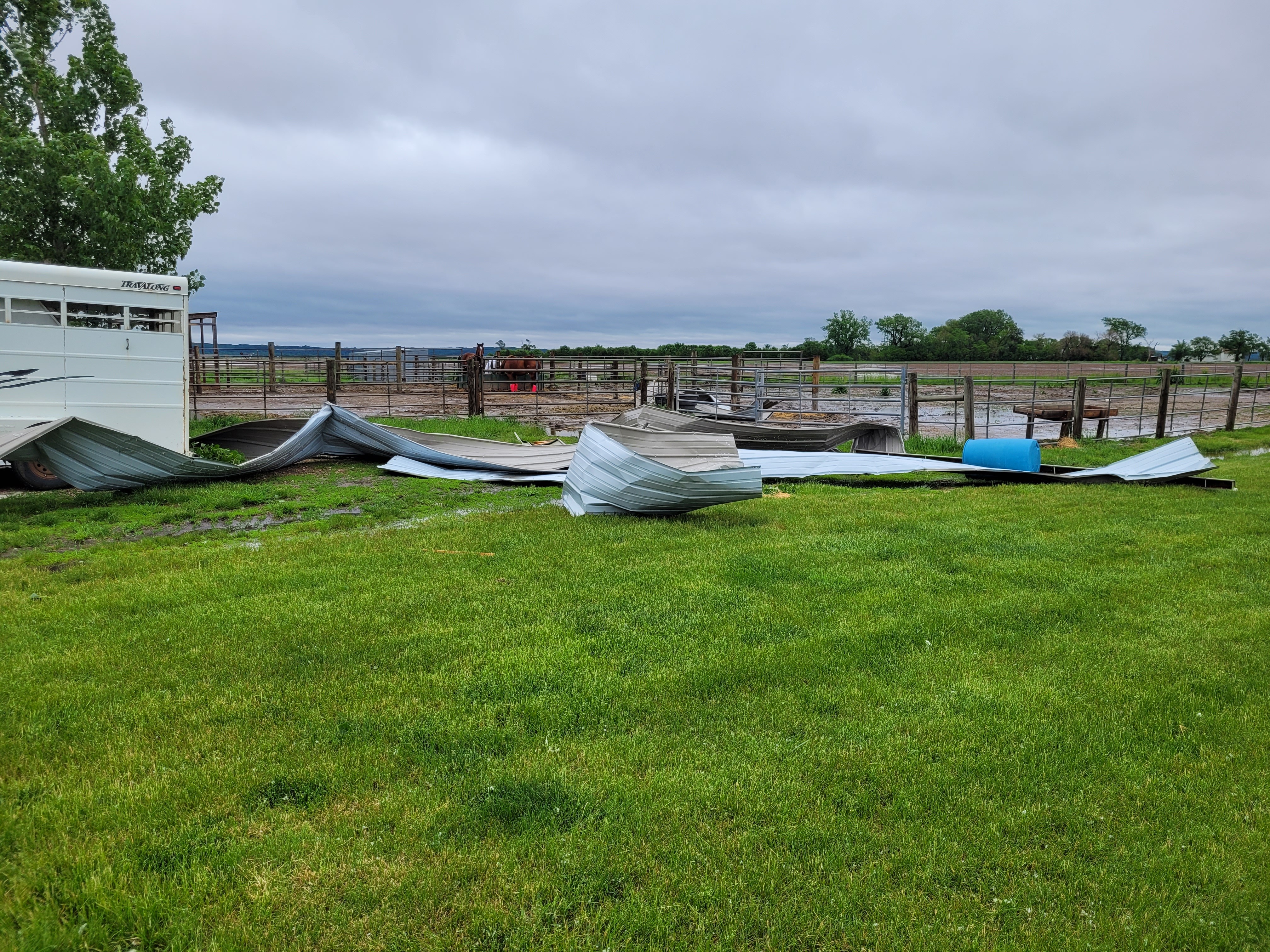
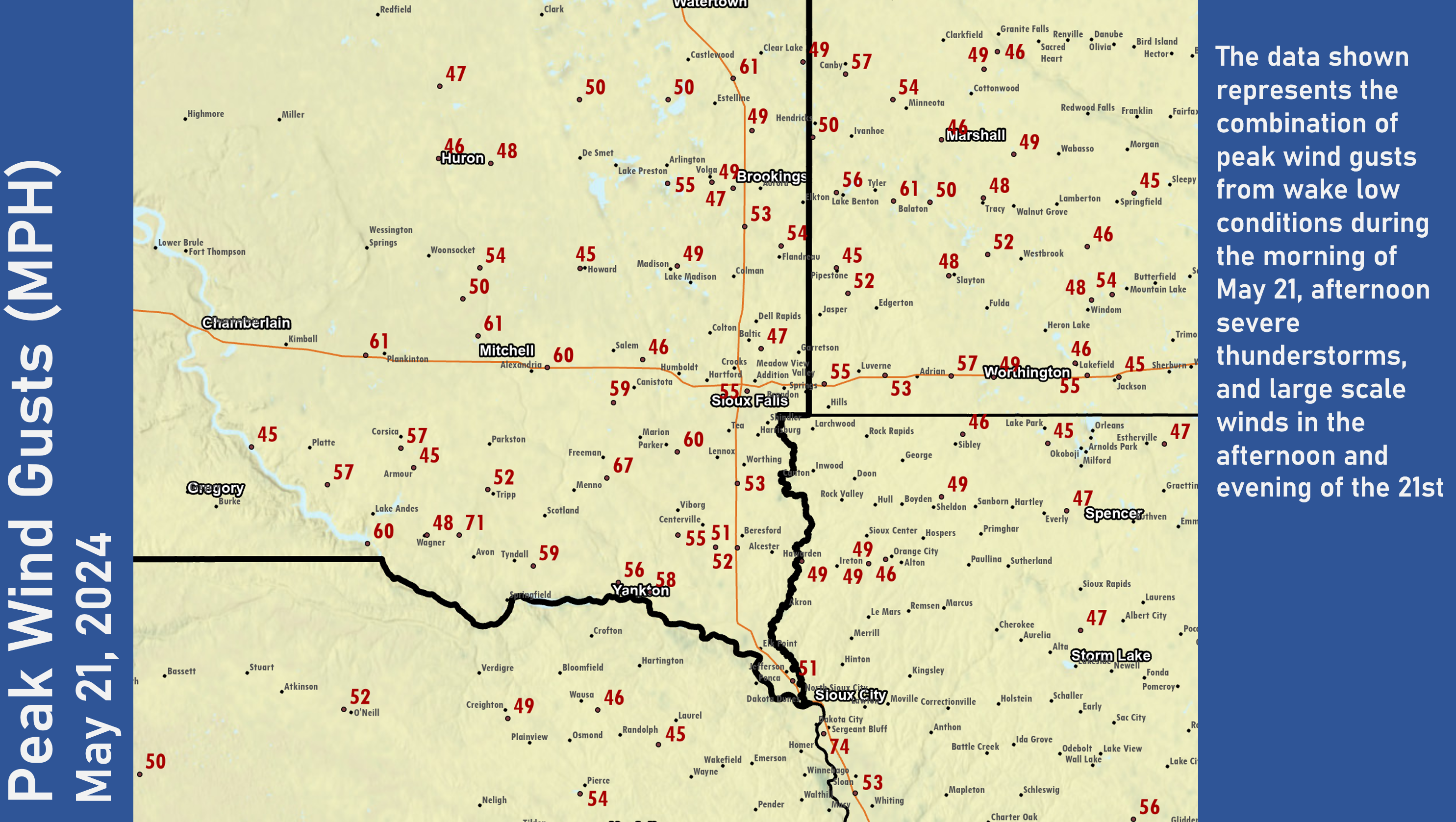
A long duration storm system brought large hail, damaging winds, and heavy rainfall to the region from the afternoon hours on May 20 through the evening of May 21. Supercell thunderstorms which developed over portions of the Tri-State area on the evening of the 20th, produced hail up to 3" in diameter in the city of Royal, IA. Additional large hail near Elk Point, SD produced hail depths approaching 6 or more inches. This event also featured a strong wake low on the morning of May 21st which brought powerful winds in excess of 50-60+ mph to parts of southeast South Dakota. These winds led to additional tree damage and power outages. Another round of storms moved into the area out of Nebraska during the evening of the 21st. These storms lead to heavy rainfall and several warnings for high winds. There was one tornado reported in Buena Vista county on the afternoon of May 21, north of the city of Alta, IA. No injuries or fatalities were reported, although there were three homesteads damaged.
|
 Standing Water from Heavy Rain on May 21st - Near Superior, IA (Dickinson County EM) |
Tornadoes:
|
Tornado - 5 WNW Truesdale
Track Map 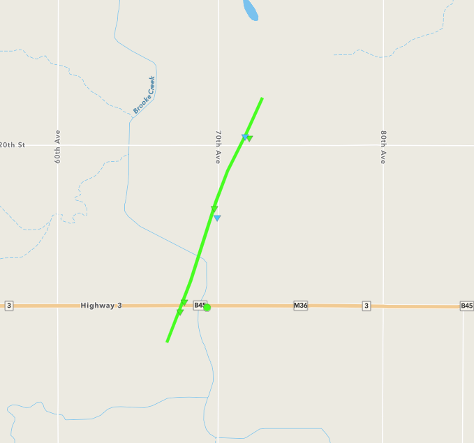  |
||||||||||||||||
The Enhanced Fujita (EF) Scale classifies tornadoes into the following categories:
| EF0 Weak 65-85 mph |
EF1 Moderate 86-110 mph |
EF2 Significant 111-135 mph |
EF3 Severe 136-165 mph |
EF4 Extreme 166-200 mph |
EF5 Catastrophic 200+ mph |
 |
|||||
Photos
 |
 |
 |
 |
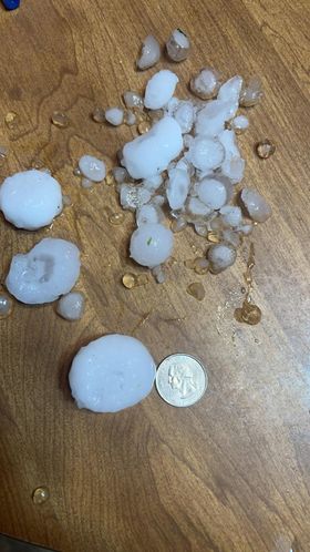
| Hail in Elk Point, SD (Public via Social Media) |
Hail in Elk Point, SD (Kathy Lawler) |
Hail in Sanborn, IA (Roger Fritz) |
Hail in Royal, IA (Cheryl Burgeson) |
 |
 |
 |
 |
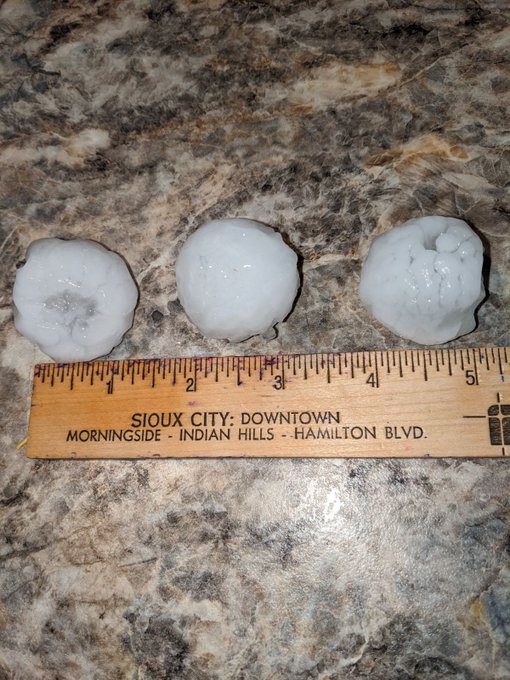
| Hail in Royal, IA (Brittney Haack) |
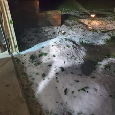
Large Branches Down, Sioux Falls (Sioux Falls EM) |
Wind Damage in Union County (Union County EM) |
Wind Damage in Union County (Union County EM) |
Radar
Radar loops from the evening of May 20 through the evening of May 21.
.gif) |
.gif) |
.gif) |
.gif) |
| Radar loop from 5 pm-11 pm on 5/20 | Radar loop from 11 pm On 5/20 to 5 am on 5/21 | Radar loop from 5 am to 11 am on 5/21 | Radar loop from 11 am to 5 pm on 5/21 |
Storm Reports
Here are some of the storm reports from around the area on the 20th into the 22nd.
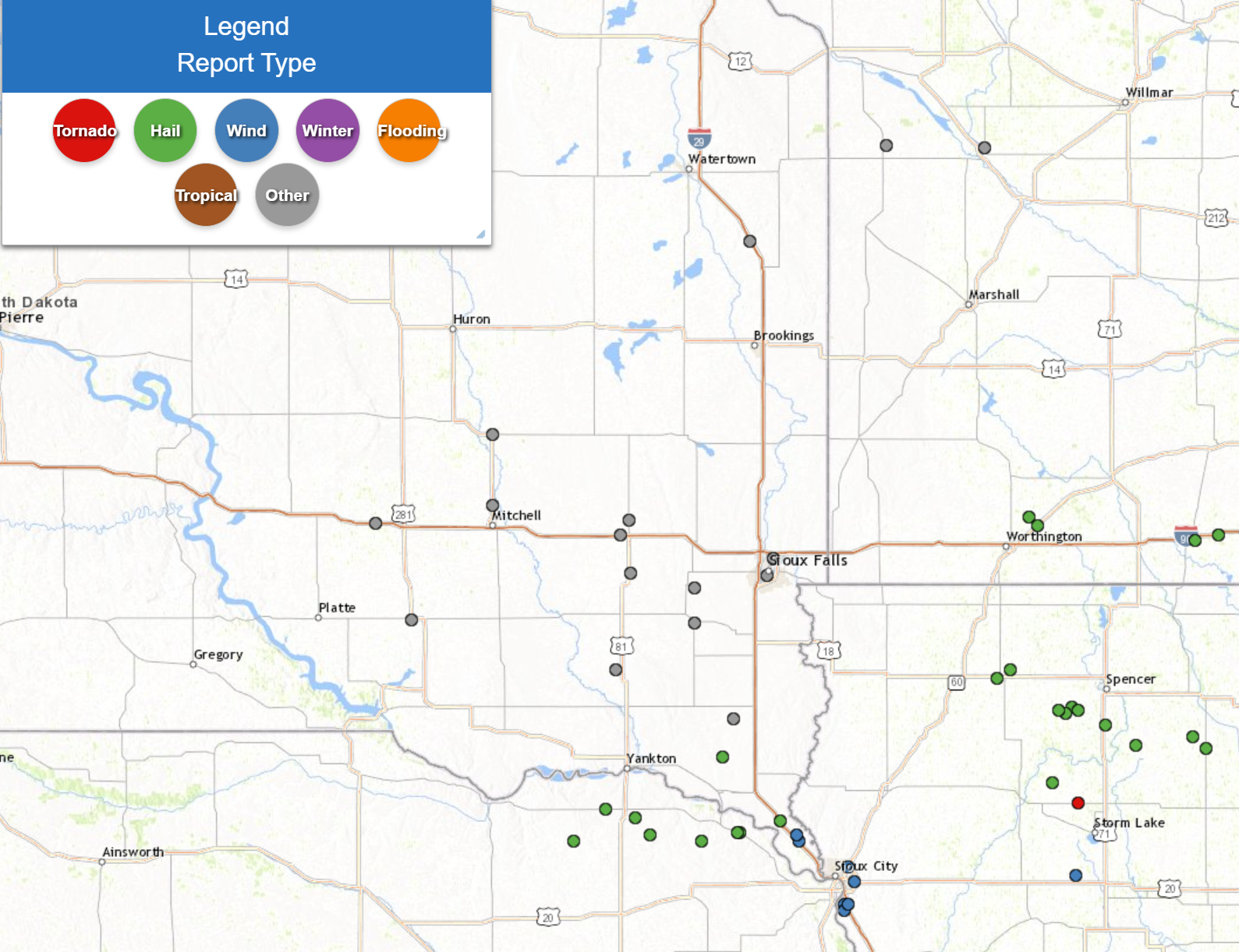 |
| 48 hour Storm Report Map from 5 PM May 20 to 5 PM May 22 (NWS Sioux Falls) |
Preliminary Local Storm Report...Summary
National Weather Service Sioux Falls SD
705 PM CDT Wed May 22 2024

..TIME...   ...EVENT...      ...CITY LOCATION...     ...LAT.LON...
..DATE...   ....MAG....      ..COUNTY LOCATION..ST.. ...SOURCE....
            ..REMARKS..

1058 PM     Tstm Wnd Dmg     3 NW Jefferson          42.64N 96.60W
05/20/2024                   Union              SD   Emergency Mngr

            Part of roof peeled off farm outbuilding.
            Time estimated from radar.

1059 PM     Hail             Elk Point               42.69N 96.68W
05/20/2024  E1.75 Inch       Union              SD   Emergency Mngr

            Quarter to golf ball sized hail, strong wind
            gusts, and heavy rain at the Sheriffs
            Office.

1100 PM     Tstm Wnd Dmg     2 NW Jefferson          42.62N 96.59W
05/20/2024                   Union              SD   Emergency Mngr

            Broken windows and portion of roof lifted
            off single family home. Downed large tree
            limbs. Time estimated from radar.

0839 AM     Non-Tstm Wnd Gst 3 ESE Parker            43.37N 97.08W
05/21/2024  M60 MPH          Turner             SD   Dept of Highways


0855 AM     Non-Tstm Wnd Gst 7 WSW Wall Lake         43.49N 97.08W
05/21/2024  M62 MPH          Turner             SD   Mesonet


0928 AM     Non-Tstm Wnd Gst 4 ESE Forestburg        44.01N 98.03W
05/21/2024  M54 MPH          Sanborn            SD   Dept of Highways


0911 AM     Non-Tstm Wnd Gst 3 NNE Sioux Falls       43.59N 96.71W
05/21/2024  M63 MPH          Minnehaha          SD   Public

            Via personal weather station. Several
            observations across the city of between
            58-63 mph.

0911 AM     Non-Tstm Wnd Dmg 1 SSW Sioux Falls       43.53N 96.74W
05/21/2024                   Minnehaha          SD   Emergency Mngr

            Power outages and a number of large tree
            branches down across the center of Sioux
            Falls.

0900 AM     Non-Tstm Wnd Gst 4 N Dolton              43.54N 97.38W
05/21/2024  M59 MPH          McCook             SD   Dept of Highways


0908 AM     Non-Tstm Wnd Dmg 4 SSW Salem             43.67N 97.43W
05/21/2024                   McCook             SD   Emergency Mngr

            Non-thunderstorm wind gust blew 40 foot
            travel trailer and pickup off I-90 near mile
            marker 362. Nearby anemometer at I-90 and
            Hwy 81 measured a gust to 51 mph.

0910 AM     Non-Tstm Wnd Dmg Salem                   43.72N 97.39W
05/21/2024                   McCook             SD   Emergency Mngr

            Small tree limbs down in Salem.

0824 AM     Non-Tstm Wnd Gst 7 ESE Menno             43.21N 97.45W
05/21/2024  M63 MPH          Hutchinson         SD   Mesonet

            Period of sustained winds of 40 to 50 mph as
            well from 810 to 900 CDT.

0819 AM     Non-Tstm Wnd Gst 3 S Corsica             43.38N 98.41W
05/21/2024  M57 MPH          Douglas            SD   Dept of Highways

            Sustained winds 40 to 45 mph.

0902 AM     Non-Tstm Wnd Gst 2 N Mitchell            43.77N 98.03W
05/21/2024  M61 MPH          Davison            SD   ASOS


0952 PM     Hail             8 NE Meckling           42.91N 96.95W
05/20/2024  E1.00 Inch       Clay               SD   Trained Spotter

            Lots of nickel to quarter sized hail.

0825 AM     Non-Tstm Wnd Gst 6 SSE Centerville       43.04N 96.90W
05/21/2024  M51 MPH          Clay               SD   Mesonet

            Sustained winds peaked 43 mph at 0825 CDT.

1030 PM     Hail             Newcastle               42.65N 96.88W
05/20/2024  E1.75 Inch       Dixon              NE   Trained Spotter

            Lots of quarter to golf ball sized hail.
            Ground covered in hail.

1030 PM     Hail             Newcastle               42.65N 96.87W
05/20/2024  E2.00 Inch       Dixon              NE   Public

            Hail pea size to 2 inches in diameter. Hail
            damage to siding, roofs, windows, and
            vehicles.

0927 PM     Hail             3 NW Brewster           43.73N 95.51W
05/20/2024  E1.50 Inch       Nobles             MN   Trained Spotter

            Time estimated from radar.

0928 PM     Hail             Brewster                43.70N 95.47W
05/20/2024  E1.00 Inch       Nobles             MN   Public


1042 PM     Tstm Wnd Gst     1 W Sergeant Bluff      42.40N 96.38W
05/20/2024  M72 MPH          Woodbury           IA   ASOS


1042 PM     Tstm Wnd Dmg     Sergeant Bluff          42.40N 96.36W
05/20/2024                   Woodbury           IA   Emergency Mngr

            Lots of trees down, some siding damage, and
            power lines down around Sergeant Bluff.

1042 PM     Hail             Sergeant Bluff          42.40N 96.36W
05/20/2024  E1.25 Inch       Woodbury           IA   Broadcast Media

            Viewer reports of half dollar or slightly
            larger hail in Sergeant Bluff area. Ground
            covered in hail.

0619 AM     Tstm Wnd Gst     2 SW Sergeant Bluff     42.38N 96.38W
05/21/2024  M71 MPH          Woodbury           IA   ASOS

            ASOS station KSUX Sioux Gateway Airport.

0624 AM     Tstm Wnd Dmg     2 NE Sioux City         42.53N 96.36W
05/21/2024                   Woodbury           IA   Broadcast Media

            Several trees and large branches down along
            Floyd Blvd in Sioux City. Time estimated via
            radar.

0626 AM     Tstm Wnd Gst     4 ESE Sioux City        42.48N 96.33W
05/21/2024  M60 MPH          Woodbury           IA   Public

            Via personal weather station. Time of peak
            wind between 6:25 and 6:30am.

0642 PM     Hail             Sanborn                 43.18N 95.66W
05/20/2024  E1.00 Inch       O`Brien            IA   Public

            Report with photo in social media.

0651 PM     Hail             Sanborn                 43.18N 95.66W
05/20/2024  M1.00 Inch       O`Brien            IA   Public

            Report from mPING: Quarter (1.00 in.)
            Received a simultaneous report of 1 inch
            hail from a trained spotter.

0658 PM     Hail             Sanborn                 43.18N 95.66W
05/20/2024  M1.75 Inch       O`Brien            IA   Public


0714 PM     Hail             3 ENE Sanborn           43.21N 95.60W
05/20/2024  E1.00 Inch       O`Brien            IA   Trained Spotter


0740 PM     Hail             2 NW Royal              43.08N 95.31W
05/20/2024  E2.50 Inch       Clay               IA   Trained Spotter

            Golf ball to tennis ball sized hail, damage
            to skylight on camper, and lots of
            sticks/leaves down on the ground.

0747 PM     Hail             4 W Royal               43.07N 95.37W
05/20/2024  E2.00 Inch       Clay               IA   Public

            Report from mPING: Hen Egg (2.00 in.).

0754 PM     Hail             3 W Royal               43.06N 95.34W
05/20/2024  M3.00 Inch       Clay               IA   Trained Spotter

            Report and photo from storm chaser via
            social media.

0815 PM     Hail             Greenville              43.02N 95.15W
05/20/2024  E1.50 Inch       Clay               IA   Public


0832 PM     Hail             Webb                    42.95N 95.01W
05/20/2024  E1.50 Inch       Clay               IA   Public

            Hail pea to ping-pong ball size.

0915 PM     Hail             Royal                   43.07N 95.28W
05/20/2024  M2.00 Inch       Clay               IA   Public

            Social media report with pictures and tape
            measure for reference.

0935 PM     Hail             7 SSW Peterson          42.82N 95.40W
05/20/2024  M1.50 Inch       Cherokee           IA   Emergency Mngr

            Relayed report from member of the public.
            Radar estimated.

0230 PM     Tornado          5 WNW Truesdale         42.75N 95.28W
05/21/2024                   Buena Vista        IA   Emergency Mngr

            Damage reported near Hwy 3 and 70th Ave.


&&
|
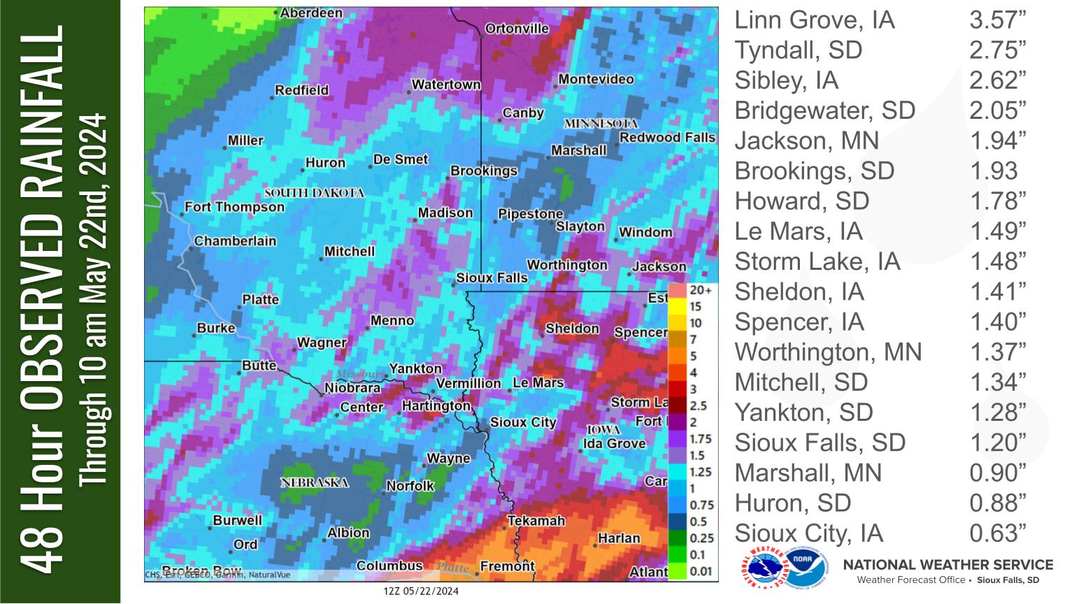
Rain Reports
Here's a look at rainfall reports from across the region.
 |
|||||||||||||||||||||||||||||||||||||||||||||||||||||||||||||||||||||||||||||||||||||||||||||||||||||||||||||||||||||||||||||||||||||||||||||||||||||||||||||||||||||||||||||||||||||||||||||||||||||||||||||||||||||||||||||||||||||||||||||||||||||||||||||||||||||||||||||||||||||||||||||||||||||||||||||||||||||||||||||||||||||||||||||||||||||||||||||||||||||||||||||||||||||||||||||||||||||||||||||||||||||||||
| 48 Hour Rainfall Map including May 20th to May 22nd (NWS Sioux Falls) |
|||||||||||||||||||||||||||||||||||||||||||||||||||||||||||||||||||||||||||||||||||||||||||||||||||||||||||||||||||||||||||||||||||||||||||||||||||||||||||||||||||||||||||||||||||||||||||||||||||||||||||||||||||||||||||||||||||||||||||||||||||||||||||||||||||||||||||||||||||||||||||||||||||||||||||||||||||||||||||||||||||||||||||||||||||||||||||||||||||||||||||||||||||||||||||||||||||||||||||||||||||||||||
|
 |
Media use of NWS Web News Stories is encouraged! Please acknowledge the NWS as the source of any news information accessed from this site. |
|


 Weather Story
 Weather Map
 Local Radar