Overview
|
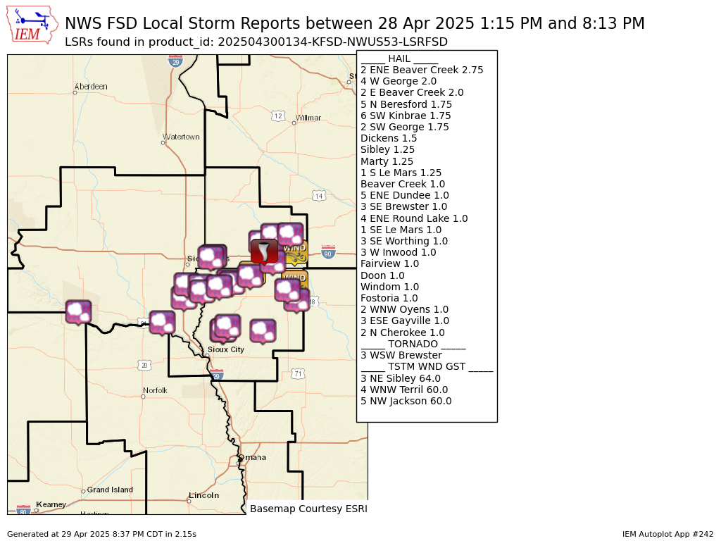
Several severe storms tracked through southwest Minnesota, northwest Iowa, and portions of southeast South Dakota (south of I-90) during the afternoon and evening on Monday, April 28, 2025. Large hail from 1 inch to 2.75" in size were most commonly observed, though a few damaging wind gusts from 60 to 64 MPH were also reported. There was also a brief tornado touchdown in an open field with no known damage southwest of Brewster, Minnesota. |
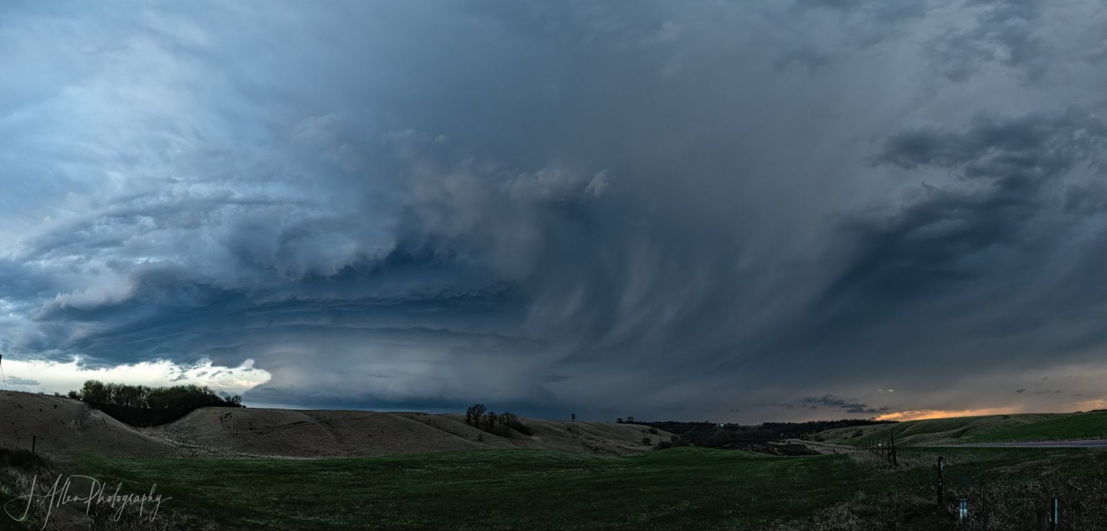 Supercell thunderstorm near Jackson, Minnesota (Photo credit: Judy Allen) |
Storm Reports
Preliminary Local Storm Report...Summary
National Weather Service Sioux Falls SD
834 PM CDT Tue Apr 29 2025

..TIME...   ...EVENT...      ...CITY LOCATION...     ...LAT.LON...
..DATE...   ....MAG....      ..COUNTY LOCATION..ST.. ...SOURCE....
            ..REMARKS..

0240 PM     Tornado          3 WSW Brewster          43.68N 95.53W
04/28/2025                   Nobles             MN   Storm Chaser

            Brief touchdown in an open field. No known
            damage.

0245 PM     Hail             6 SW Kinbrae            43.78N 95.57W
04/28/2025  E1.75 Inch       Nobles             MN   Public

            Report via social media.

0535 PM     Hail             Marty                   42.99N 98.43W
04/28/2025  E1.25 Inch       Charles Mix        SD   Public

            Quarters to slightly larger hail reported
            via social media. Time estimated by radar.

0643 PM     Hail             3 W Inwood              43.29N 96.51W
04/28/2025  M1.00 Inch       Lyon               IA   Public

            Report via social media.

0648 PM     Hail             Fairview                43.22N 96.49W
04/28/2025  E1.00 Inch       Lincoln            SD   Public

            Report via social media.

0700 PM     Hail             Doon                    43.28N 96.23W
04/28/2025  E1.00 Inch       Lyon               IA   Public

            Report via social media.

0115 PM     Hail             Beaver Creek            43.61N 96.36W
04/28/2025  M1.00 Inch       Rock               MN   Trained Spotter


0126 PM     Hail             2 E Beaver Creek        43.62N 96.32W
04/28/2025  M2.00 Inch       Rock               MN   Public

            Report from mPING: Hen Egg (2.00 in.).

0127 PM     Hail             2 ENE Beaver Creek      43.62N 96.32W
04/28/2025  M2.75 Inch       Rock               MN   Public

            Non-uniform hail measured at 2.8 inches at
            its widest.

0254 PM     Hail             5 ENE Dundee            43.86N 95.38W
04/28/2025  M1.00 Inch       Cottonwood         MN   Emergency Mngr

            Lots of quarter size hail.

0306 PM     Hail             3 SE Brewster           43.66N 95.43W
04/28/2025  M1.00 Inch       Jackson            MN   Public


0316 PM     Hail             Windom                  43.87N 95.12W
04/28/2025  M1.00 Inch       Cottonwood         MN   Emergency Mngr


0318 PM     Hail             4 ENE Round Lake        43.56N 95.39W
04/28/2025  M1.00 Inch       Jackson            MN   Public

            ground covered in nickel to quarter size
            hail.

0333 PM     Tstm Wnd Gst     5 NW Jackson            43.67N 95.05W
04/28/2025  M60 MPH          Jackson            MN   Public


0428 PM     Tstm Wnd Gst     4 WNW Terril            43.33N 95.05W
04/28/2025  E60 MPH          Dickinson          IA   Public

            Estimated 50 to 60 mph wind gusts along with
            small branches down. Pea sized hail also
            reported.

0429 PM     Hail             Fostoria                43.24N 95.16W
04/28/2025  M1.00 Inch       Clay               IA   Emergency Mngr


0520 PM     Hail             Dickens                 43.13N 95.02W
04/28/2025  M1.50 Inch       Clay               IA   Emergency Mngr

            Mostly dime to quarter sized, but some as
            large as ping pong balls. Time estimated via
            radar.

0604 PM     Hail             1 S Le Mars             42.77N 96.17W
04/28/2025  E1.25 Inch       Plymouth           IA   Public


0604 PM     Hail             1 SE Le Mars            42.78N 96.16W
04/28/2025  E1.00 Inch       Plymouth           IA   Trained Spotter

            Nickel to quarter size hail from 604 to 610
            pm. A few stones slightly larger than
            quarter size.

0611 PM     Hail             2 WNW Oyens             42.83N 96.10W
04/28/2025  E1.00 Inch       Plymouth           IA   Public


0628 PM     Hail             5 N Beresford           43.15N 96.78W
04/28/2025  E1.75 Inch       Lincoln            SD   Public

            Quarter to golf ball sized hail reported via
            social media.

0643 PM     Hail             3 SE Worthing           43.30N 96.73W
04/28/2025  E1.00 Inch       Lincoln            SD   Trained Spotter

            Hail up to quarter size along U.S. Highway
            18 and Minnesota Ave.

0708 PM     Hail             4 W George              43.34N 96.08W
04/28/2025  E2.00 Inch       Lyon               IA   Public

            Hen egg sized hail reported via broadcast
            media.

0709 PM     Hail             2 SW George             43.32N 96.03W
04/28/2025  E1.75 Inch       Lyon               IA   Public

            Ping pong to golf ball sized hail reported
            via social media.

0717 PM     Hail             3 ESE Gayville          42.87N 97.12W
04/28/2025  M1.00 Inch       Clay               SD   Trained Spotter


0725 PM     Hail             Sibley                  43.40N 95.74W
04/28/2025  E1.25 Inch       Osceola            IA   Public

            Quarter to half dollar sized hail reported
            via social media.

0735 PM     Tstm Wnd Gst     3 NE Sibley             43.43N 95.71W
04/28/2025  M64 MPH          Osceola            IA   Mesonet

            Mesonet station RSYI4 Sibley.

0813 PM     Hail             2 N Cherokee            42.77N 95.55W
04/28/2025  E1.00 Inch       Cherokee           IA   Public
&&
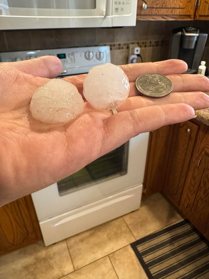
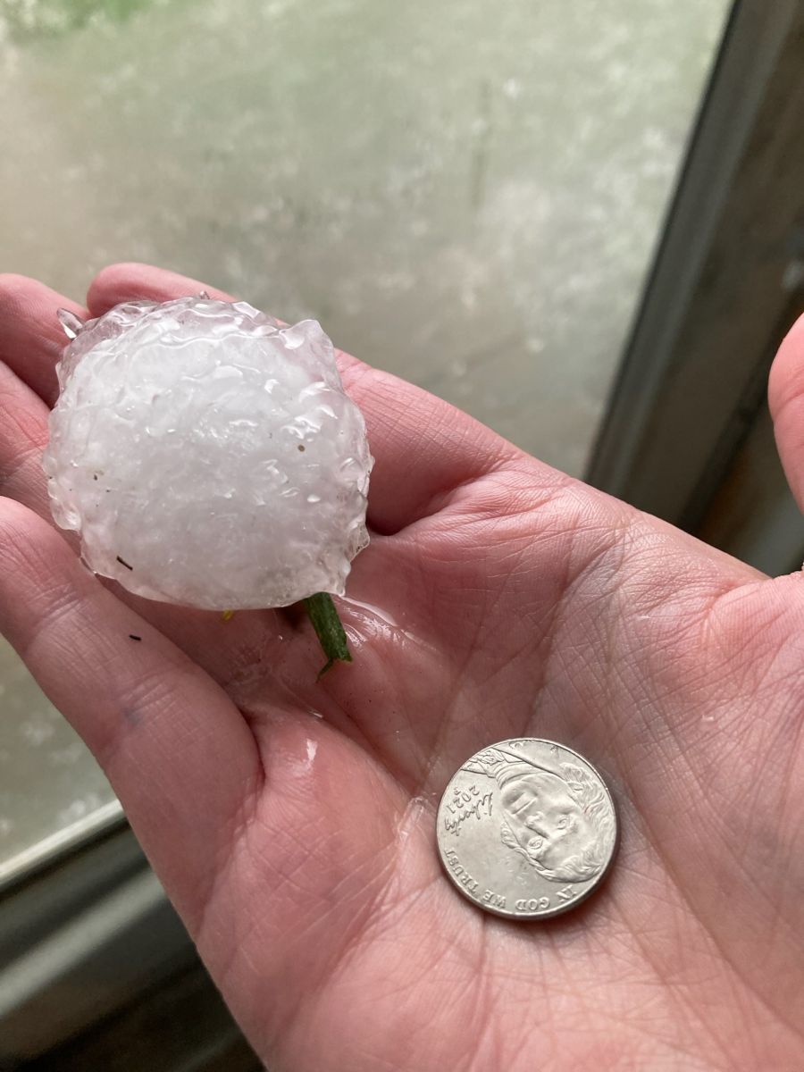
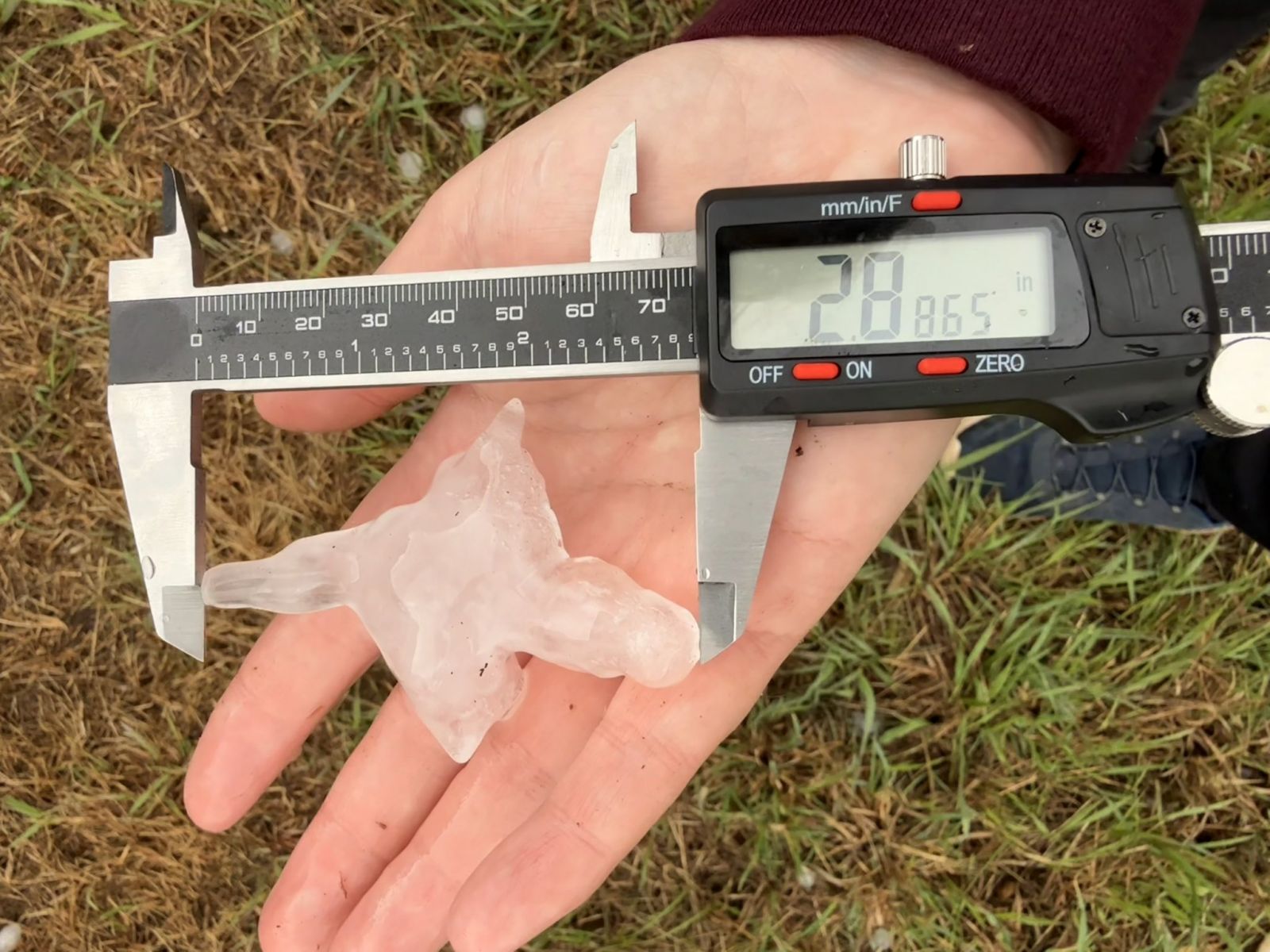
Hail
Here's a look at some of the hail which fell across the area.
|
|
 |
 |
 |
|
Large Hail East of Beaver Creek, MN (Dan Whittaker) |
Hail in Sibley, IA (Megan Ann Thole) |
Hail in Worthington, MN (Lindsey Busch) |
Hail South of Beresford, SD (Michael Mullinix) |
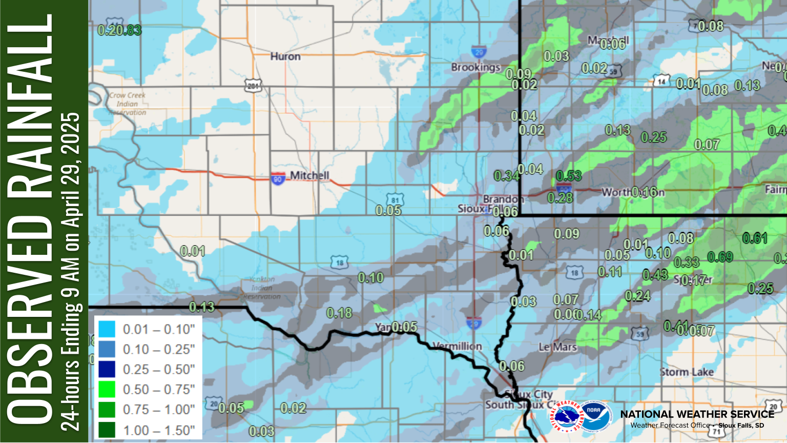
Rain Reports
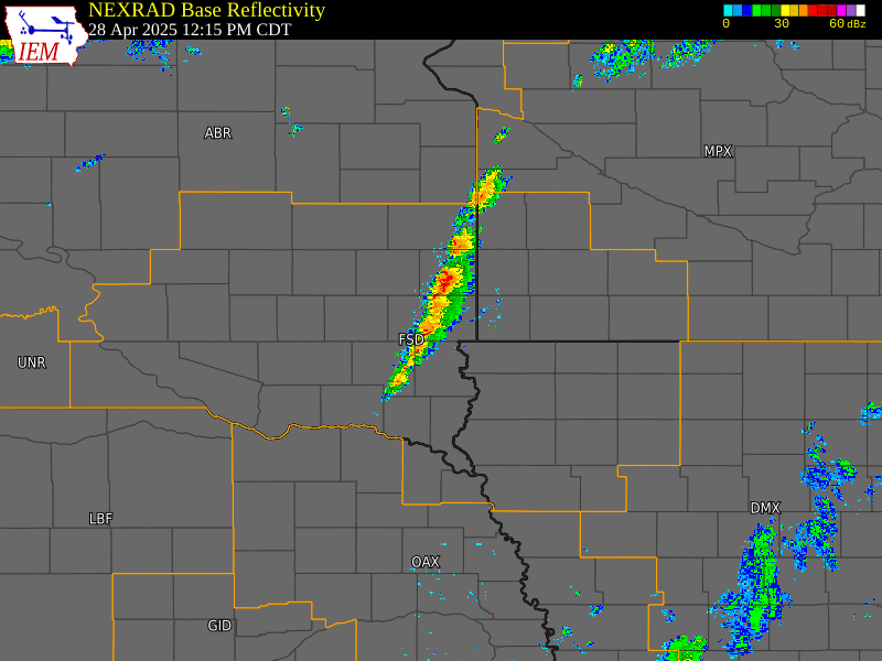
Radar
Loop from 12:15 pm through 9 pm CDT on April 28, 2025
 |
Media use of NWS Web News Stories is encouraged! Please acknowledge the NWS as the source of any news information accessed from this site. |
|


 Weather Story
 Weather Map
 Local Radar