Overview
|
A hot early June day brought a risk of strong to severe thunderstorms to portions of the Tri-State area during the late afternoon and evening hours of Monday. These thunderstorms also produced locally heavy rainfall with scattered reports of 2 to 4" inches of rainfall. |
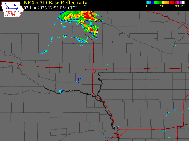 Radar Animation - June 2, 2025 |
 |
 |
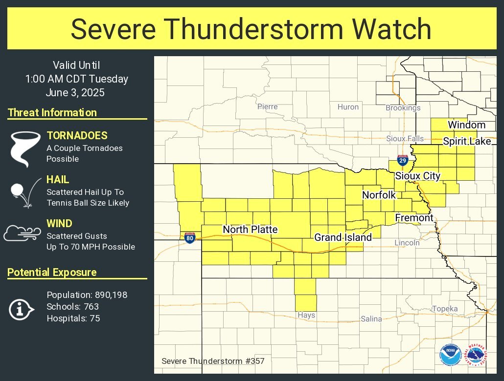 |
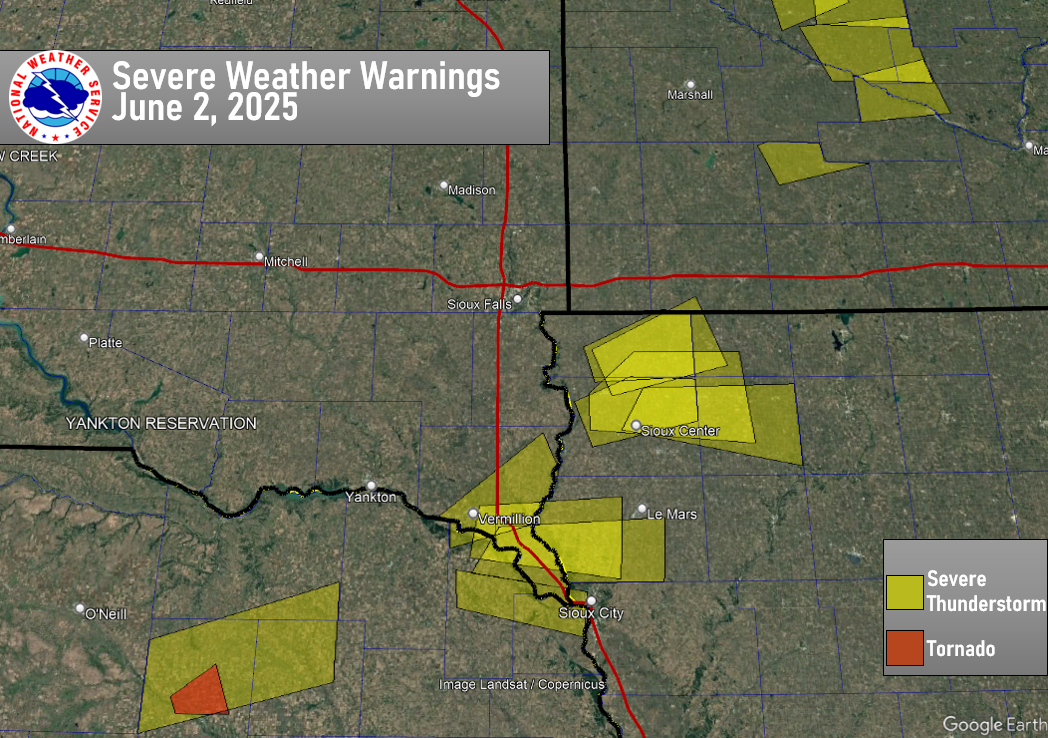
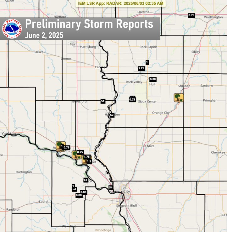
| Severe Weather Warnings - June 2 | Preliminary Storm Reports - June 2 | Severe Thunderstorm Watch - June 2 |
Storm Reports
The following is a listing of preliminary severe weather reports for June 2, 2025. As more information about the event is collected, additional reports may be added.
|
|||||||||||||||||||||||||||||||||||||||||||||||||||||||||||||||||||||||||||||||||||||||||||||||||||||||||||||||||||||||||||||||||||||||||||||||||||||||||||||||||||||||||||||||||||||
24 hour Rain Reports
Public Information Statement
National Weather Service Sioux Falls SD
1144 AM CDT Tue Jun 3 2025

...24 HOUR PRECIPITATION REPORTS...

Location                     Amount    Time/Date       Provider

...Iowa...

...Buena Vista County...
Storm Lake 3.1 S             1.79 in   1025 AM 06/03   COCORAHS
0.8 SW Linn Grove            1.58 in   1100 AM 06/03   COOP

...Cherokee County...
0.9 NE Cherokee              1.13 in   0800 AM 06/03   COOP

...Dickinson County...
Spirit Lake                  1.67 in   1116 AM 06/03   CWOP
TERRIL                       1.34 in   1119 AM 06/03   CWOP
Milford                      1.26 in   1115 AM 06/03   CWOP
Lake Park                    1.15 in   1110 AM 06/03   CWOP
Lake Park 0.2 N              1.01 in   0800 AM 06/03   COCORAHS

...Lyon County...
4 SW George                  2.83 in   1115 AM 06/03   AWS

...OBrien County...
Hartley                      1.39 in   1115 AM 06/03   CWOP
Sheldon                      1.28 in   0700 AM 06/03   COOP

...Plymouth County...
Loess Hills Tnc Broken       2.02 in   1111 AM 06/03   RAWS
Remsen                       1.45 in   0700 AM 06/03   COOP
6 NNE Jefferson              1.44 in   0700 AM 06/03   COCORAHS
6.2 NW Hinton                1.27 in   1045 AM 06/03   UCOOP
Le Mars 0.9 SE               1.21 in   0700 AM 06/03   COCORAHS
Le Mars 1.0 E                1.15 in   0530 AM 06/03   COCORAHS
Le Mars                      1.14 in   0800 AM 06/03   COOP

...Sioux County...
Sioux Center                 2.76 in   1115 AM 06/03   CWOP
Ireton 5.5 N                 2.46 in   0700 AM 06/03   COCORAHS
Hawarden                     2.11 in   1120 AM 06/03   CWOP
Orange City 0.4 NNE          1.12 in   0700 AM 06/03   COCORAHS

...Woodbury County...
1 ENE Dakota City            2.31 in   1118 AM 06/03   AWS
Sioux Gateway Airport        2.13 in   1052 AM 06/03   ASOS
SIOUX CITY                   1.80 in   1115 AM 06/03   CWOP
3.4 N Hornick                1.65 in   0700 AM 06/03   COOP
Sioux City                   1.50 in   0600 AM 06/03   COOP
Sioux City                   1.03 in   1119 AM 06/03   CWOP

...Minnesota...

...Jackson County...
Okabena 3.1 SW               1.30 in   0700 AM 06/03   COCORAHS
6 NW Orleans                 1.28 in   1115 AM 06/03   AWS
Lakefield                    1.03 in   1111 AM 06/03   CWOP

...Nobles County...
Worthington 1.9 SW           1.38 in   0700 AM 06/03   COCORAHS
Worthington 4.0 S            1.04 in   0700 AM 06/03   COCORAHS

...Nebraska...

...Dakota County...
South Sioux City             2.14 in   1115 AM 06/03   CWOP
Dakota City 0.48 S           1.25 in   0700 AM 06/03   COCORAHS

...Dixon County...
1 WNW Ponca                  4.10 in   0800 AM 06/03   COCORAHS
Concord 4.23 S               1.55 in   0700 AM 06/03   COCORAHS
Newcastle                    1.40 in   0600 AM 06/03   COOP

...South Dakota...

...Clay County...
Vermillion 0.6 SE            2.12 in   0800 AM 06/03   COCORAHS
Vermillion 1.4 SE            2.11 in   0600 AM 06/03   COCORAHS

...Lincoln County...
Worthing 2.0 W               1.37 in   0700 AM 06/03   COCORAHS
Canton                       1.05 in   0600 AM 06/03   COOP

...Turner County...
SD RWIS IRENE                1.89 in   1111 AM 06/03   SDDOT
Hurley 0.2 S                 1.34 in   0600 AM 06/03   COCORAHS
SD RWIS Parker               1.19 in   1110 AM 06/03   SDDOT

...Union County...
Elk Point 0.3 WSW            4.08 in   0700 AM 06/03   COCORAHS
Jefferson 2.9 SW             2.55 in   0700 AM 06/03   COCORAHS
Jefferson 4.9 S              2.09 in   0700 AM 06/03   COCORAHS
Jefferson 2.1 WNW            2.08 in   0700 AM 06/03   COCORAHS
Jefferson 1.1 E              2.07 in   0700 AM 06/03   COCORAHS
1 WNW Jefferson              1.00 in   0700 AM 06/03   COCORAHS

...Yankton County...
SD RWIS Gayville             1.58 in   1110 AM 06/03   SDDOT
Yankton 8.1 W                1.08 in   0800 AM 06/03   COCORAHS
Yankton 9.1 W                1.01 in   0700 AM 06/03   COCORAHS

Observations are collected from a variety of sources with varying
equipment and exposures. We thank all volunteer weather observers
for their dedication. Not all data listed are considered official.

$$
Photos & Video
 |
 |
 |
 |
|
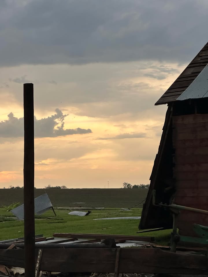
Thunderstorm Wind Damage (Credit: Angela Kreykes) |
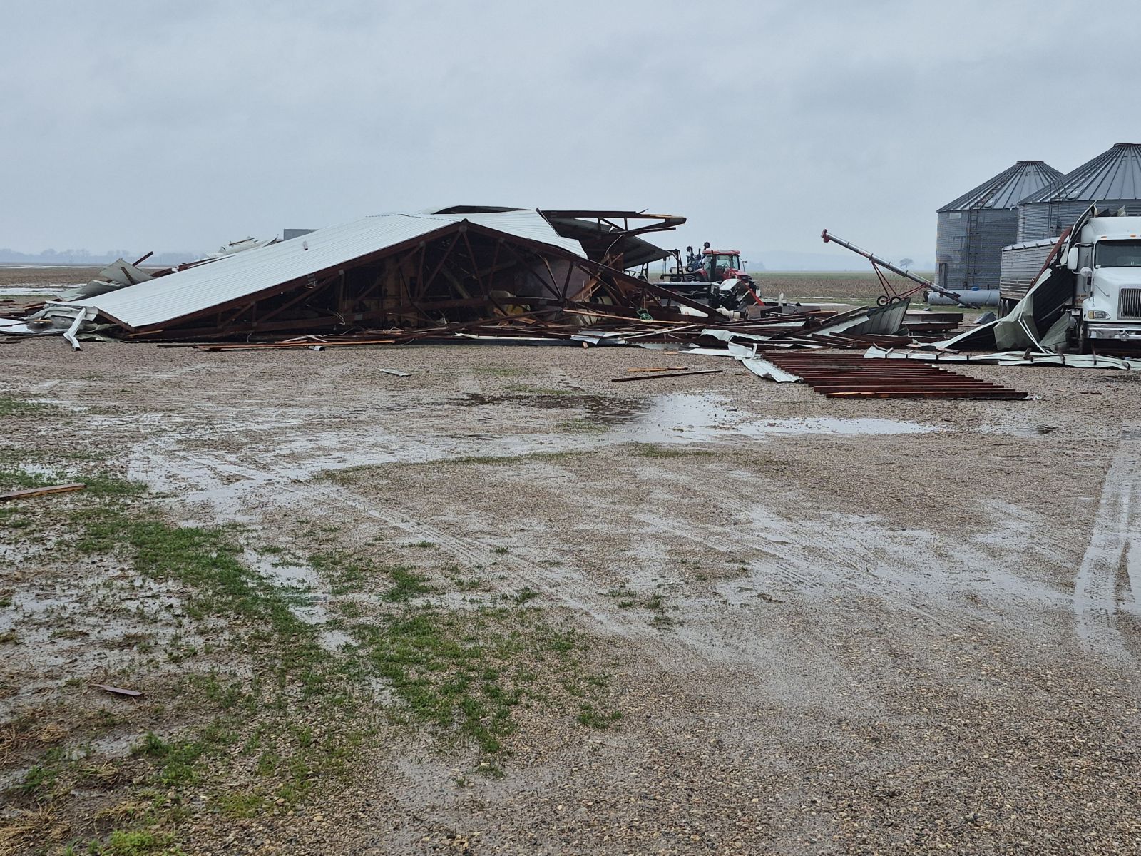
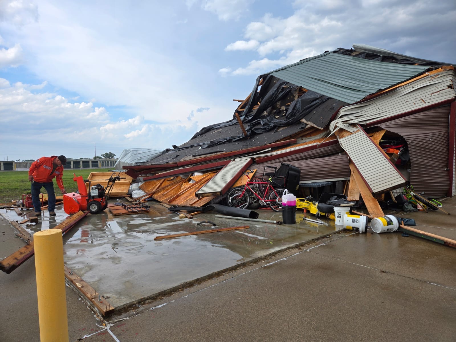
Thunderstorm Wind Damage |
Thunderstorm Wind Damage |
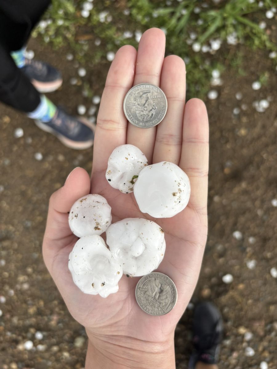
Large Hail west of |
 |
Media use of NWS Web News Stories is encouraged! Please acknowledge the NWS as the source of any news information accessed from this site. |
|


 Weather Story
 Weather Map
 Local Radar