Overview
|
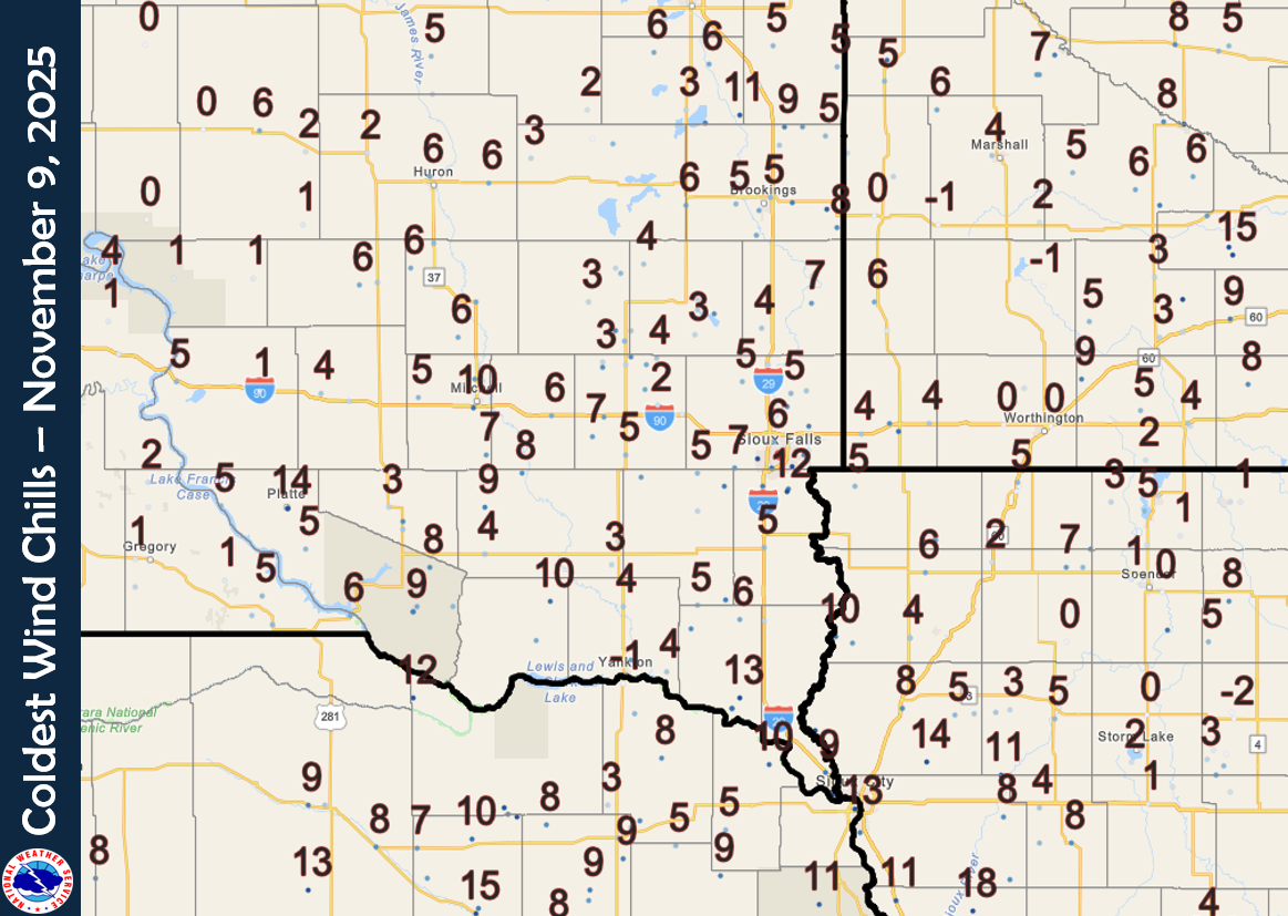
Winter made its first official appearance, as a significant snowfall moved across the Tri-State area on November 8th. Developing after midnight, the system gradually advanced southeast throughout the day, bringing the region its inaugural measurable accumulation. The snowfall was notably intense at times, with mid-morning reports indicating rates reached between a half-inch and a full inch per hour. By the time the event concluded, residents across the region reported widespread totals of 1 to 4 inches, though some localized, higher pockets were noted. The departing storm system ushered in a significant drop in temperatures. Overnight lows in many locations plummeted toward the teens, creating hazardous conditions. Accompanying a surge in wind speed, these frigid conditions contributed to minor snow drifting, further impacting travel and cleanup efforts. |
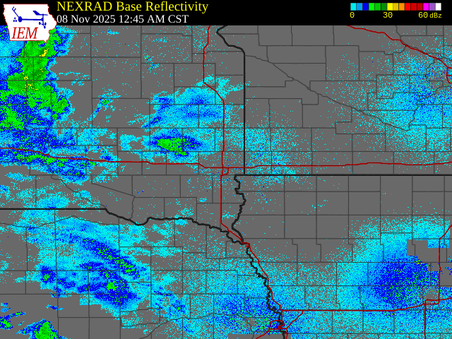 Radar Reflectivity - November 8, 2025 |
.png) |
 |
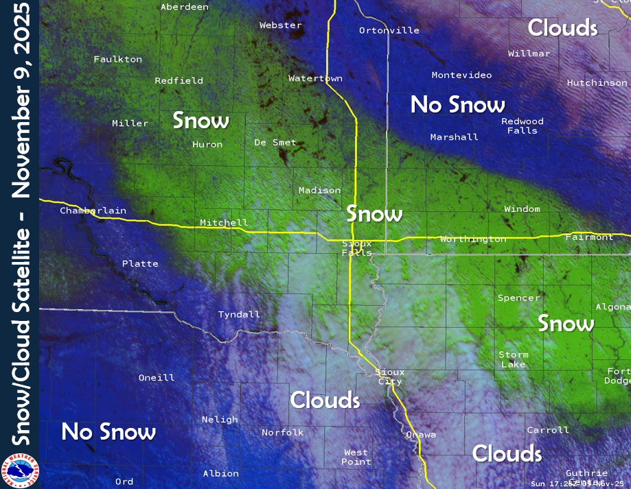 |
| Snowfall Analysis - November 8, 2025 | Coldest Wind Chills - November 8-9, 2025 | Satellite and Snow View - November 9th |
Storm Reports
Here is a listing of the highest snowfall reports during the November 8, 2025 winter weather event. This listing of reports may not include all of the reports received from this event, but highlight the highest totals in each county area.
|
| Storm Total Snowfall Analysis - November 8, 2025 |
Public Information Statement National Weather Service Sioux Falls SD 1141 AM CST Sun Nov 9 2025 ...STORM TOTAL SNOWFALL REPORTS NOVEMBER 8-9, 2025... Location Amount ...Iowa... ...Buena Vista County... Sioux Rapids 3.6 in ...Cherokee County... Cherokee 4.5 NNW 4.1 in ...Dickinson County... 3 SSE Lake Park 5.1 in 1 ESE Spirit Lake 4.5 in ...Lyon County... 2 NNE Inwood 3.5 in ...OBrien County... Sanborn 5.0 in ...Plymouth County... Remsen 3.0 in 1 ENE Le Mars 2.0 in ...Sioux County... 2.1 SE Sioux Center 4.0 in 3 N Sioux Center 4.0 in Orange City 3.3 in Hull 3.0 in Orange City 0.4 WNW 3.0 in ...Woodbury County... 3 NNE Sioux City 1.0 in Sergeant Bluff 1.0 in 3.4 N Hornick T in ...Minnesota... ...Cottonwood County... 2.6 NW Windom 2.5 in ...Lincoln County... Hendricks 8.0 SE 0.2 in ...Murray County... Chandler 2.8 WNW 2.0 in ...Nobles County... Wilmont 4.0 in Brewster 3.5 in Worthington 3.0 in 2 NE Worthington 2.0 in ...Pipestone County... Edgerton 3.5 in 1 NNW Pipestone 3.0 in Edgerton 0.2 WSW 1.0 in ...Rock County... 4 ENE Hardwick 3.0 in Hills 0.2 NW 3.0 in ...Nebraska... ...Dakota County... Hubbard 3.1 SW 0.5 in ...Dixon County... 3 NNW Ponca 2.5 in ...South Dakota... ...Aurora County... 1 N Plankinton 3.0 in Stickney 3.8 SW 2.0 in ...Beadle County... 2 S Huron 2.6 in ...Bon Homme County... Tyndall 1.3 in ...Brookings County... Brookings 0.2 SSW 2.1 in Aurora 0.3 NE 2.0 in Brookings 1.4 SW 2.0 in 6 SSW Brookings 2.0 in Astoria 2.2 SSE 2.0 in Brookings 2 NE 1.7 in 2 NE Brookings 1.7 in Brookings 2 NE 1.6 in White 0.4 WNW 1.5 in Brookings 0.2 SSW 1.0 in ...Brule County... Pukwana 1.9 S T in ...Charles Mix County... Academy 2 NE 0.1 in ...Clay County... 1.4 S Vermillion 2.3 in Vermillion 1.4 SE 1.5 in ...Davison County... Mitchell 3.2 in Mitchell 2.5 in ...Gregory County... Burke 10.5 SSE 1.6 in Dallas 8.8 S 1.0 in ...Hanson County... Spencer 5.6 NW 3.5 in ...Hutchinson County... Parkston 6.5 WSW 3.0 in Menno 2.0 in Emery 10.8 S 1.5 in8 ...Kingsbury County... De Smet 0.2 SSE 2.0 in Arlington 9.0 SSW 2.0 in ...Lake County... 3 W Madison 3.0 in 5 SE Ramona 2.5 in Wentworth 4.7 SSW 2.0 in ...Lincoln County... 1 NNW Canton 4.7 in 4 SSE Sioux Falls 4.5 in 1 N Tea 4.0 in Sioux Falls 4.2 S 3.4 in ...McCook County... Parker 7.2 N 5.0 in Salem 4.0 in Montrose 3.5 in 5 E Canistota 3.5 in Bridgewater 3.0 in Spencer 3.0 in Montrose 5.8 NW 3.0 in ...Miner County... 1 SSW Howard 3.0 in Howard 5.3 W 2.8 in ...Minnehaha County... Sioux Falls 6.0 ENE 5.0 in Renner 4.1 NW 5.0 in Dell Rapids 4.8 in Sioux Falls 1.1 SSE 4.5 in Humboldt 3.5 in 4 WNW Rowena 3.5 in 3 N Sioux Falls 3.2 in Sioux Falls 5.2 E 3.2 in Renner 4.1 NW 3.0 in 5 W Rowena 3.0 in Hartford 0.5 N 3.0 in Sioux Falls 3.6 ESE 2.8 in ...Moody County... Flandreau 2.1 in ...Sanborn County... Letcher 0.5 E 3.1 in Woonsocket 0.2 WSW 2.5 in ...Turner County... Hurley 0.2 S 3.1 in Parker 3.0 in ...Yankton County... Yankton 3.0 in 4 W Mayfield 2.5 in Lesterville 2.5 in Observations are collected from a variety of sources with varying equipment and exposures. We thank all volunteer weather observers for their dedication. Not all data listed are considered official. |
 |
Media use of NWS Web News Stories is encouraged! Please acknowledge the NWS as the source of any news information accessed from this site. |
|


 Weather Story
 Weather Map
 Local Radar