Overview
|
A strong low pressure system moved across the area January 21st and 22nd, 2026. An initial dusting of up to 1 inch of snow fell on Tuesday January 21st. An Arctic front brought strong wind gusts, peaking up to 80 mph, on Wednesday January 22nd. Combined with scattered light snow falling into the winds and snow already on the ground, areas of blowing snow brought periodic whiteout conditions to portions of the region. The entire two-day period brought snowfall amounts up to nearly 3 inches. Some area schools, especially in southwest Minnesota, closed early due to poor visibility. |
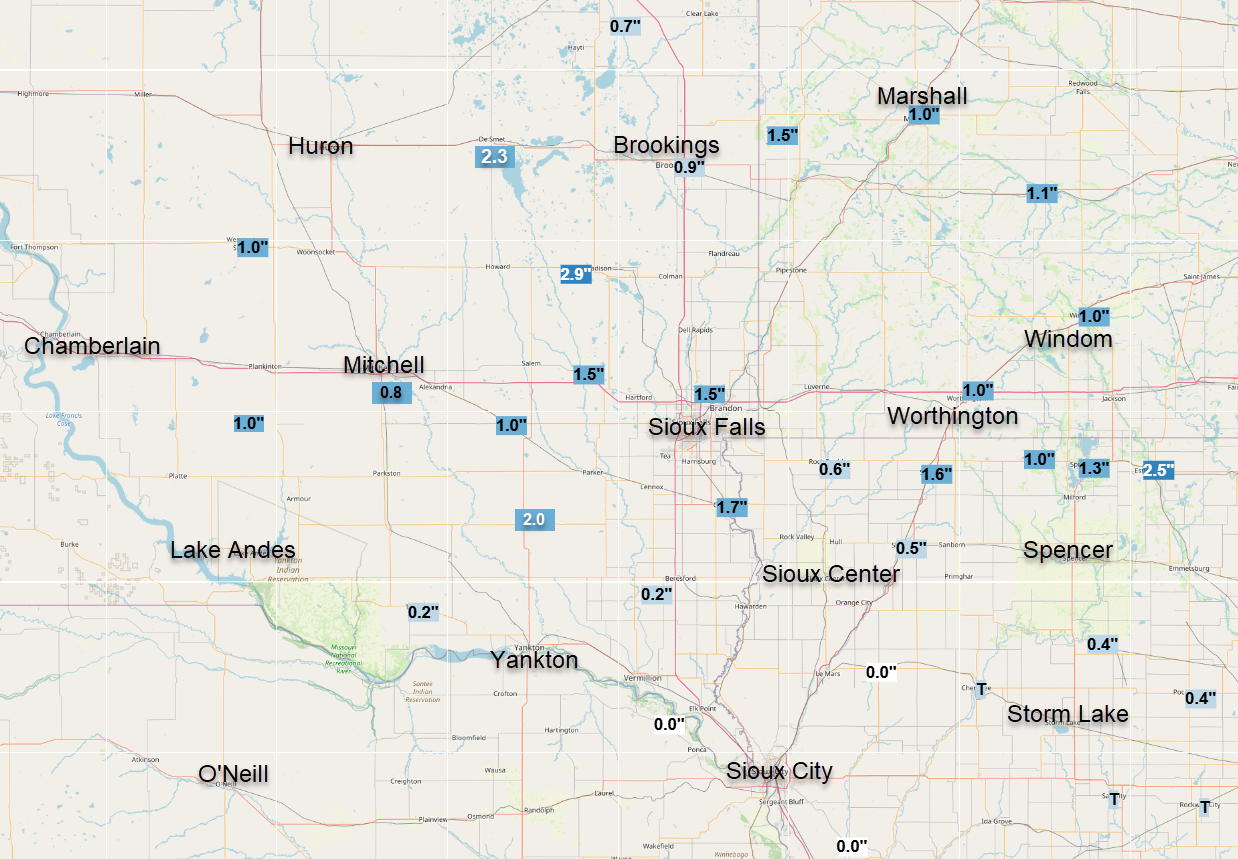 Map of Snowfall Jan 20-21, 2026 |
Snow
| City, State | 2-Day Snow Total |
| Madison, SD | 2.9" |
| Canton, SD | 1.7" |
| Sibley, IA | 1.6" |
| Montrose, SD | 1.5" |
| Sioux Falls Airport, SD | 1.5" |
| Spirit Lake, IA | 1.3" |
| Bridgewater, SD | 1.0" |
| Lake Park, IA | 1.0" |
| Marshall, MN | 1.0" |
| Wessinton Springs, SD | 1.0" |
| Windom, MN | 1.0" |
| Worthington, MN | 1.0" |
| Brookings, SD | 0.9" |
| Rock Rapids, IA | 0.6" |
| Sheldon, IA | 0.5" |
| Sioux Rapids, IA | 0.4" |
| Centerville, SD | 0.2" |
| Tyndall, SD | 0.2" |
| Cherokee, IA | Trace |
Wind
Peak Winds Wednesday January 21st, 2026
Afternoon wind gusts peaked 60-80 mph in portions of south central and southeast South Dakota, prompting a High Wind Warning.
 |
| Map of peak observed wind gusts from Wednesday January 23, 2026 |
...HIGHEST WIND REPORTS ENDING AT 4 PM CST JAN 21 2026...

Location                     Speed     Time/Date       Provider

...Iowa...

...Buena Vista County...
Storm Lake Airport           63 MPH    0215 PM 01/21   AWOS
Storm Lake                   53 MPH    0225 PM 01/21   MESOWEST

...Cherokee County...
Cherokee Municipal Airport   47 MPH    0358 PM 01/21   AWOS
Marcus                       46 MPH    0215 PM 01/21   DAVIS

...Clay County...
Spencer Municipal Airport    49 MPH    0301 PM 01/21   ASOS
Spencer                      41 MPH    0200 PM 01/21   MESOWEST

...Dickinson County...
TERRIL                       49 MPH    0239 PM 01/21   CWOP
Lake Park                    43 MPH    0330 PM 01/21   CWOP
Spirit Lake                  40 MPH    0241 PM 01/21   CWOP


...Ida County...
Battle Creek                 49 MPH    0255 PM 01/21   DAVIS
Ida Grove                    45 MPH    0140 PM 01/21   MESOWEST

...Lyon County...
Larchwood                    43 MPH    0125 PM 01/21   DAVIS

...OBrien County...
Sheldon Airport              51 MPH    0155 PM 01/21   AWOS
Hartley                      40 MPH    0145 PM 01/21   DAVIS


...Osceola County...
Sibley                       65 MPH    0115 PM 01/21   MESOWEST

...Plymouth County...
Le Mars Airport              55 MPH    0215 PM 01/21   AWOS
Remsen                       49 MPH    0205 PM 01/21   DAVIS
Sioux City                   47 MPH    0105 PM 01/21   DAVIS
Loess Hills Tnc Broken RAWS  43 MPH    0311 PM 01/21   RAWS


...Sioux County...
1 NE Maurice                 61 MPH    1255 PM 01/21   AWOS
Hawarden                     55 MPH    0200 PM 01/21   CWOP


...Woodbury County...
Sioux Gateway Airport        68 MPH    0121 PM 01/21   ASOS
Moville                      60 MPH    0215 PM 01/21   MESOWEST
Sioux City                   58 MPH    0130 PM 01/21   MESOWEST


...Minnesota...

...Cottonwood County...
T.h.60 - Mountain Lake - Mp  52 MPH    0200 PM 01/21   MESOWEST
T.h.71 - Jeffers - Mp 43     48 MPH    0355 PM 01/21   MESOWEST
Windom Municipal Airport     43 MPH    0335 PM 01/21   AWOS


...Jackson County...
I-90 - Lakefield - Mp 67     46 MPH    0335 PM 01/21   MESOWEST
Jackson Airport              44 MPH    0236 PM 01/21   AWOS


...Lincoln County...
U.s.14 - Lake Benton - Mp 7  49 MPH    0120 PM 01/21   MESOWEST
T.h.19 - Hendricks - Mp 2    46 MPH    0250 PM 01/21   MESOWEST

...Lyon County...
U.s.14 - Florence - Mp 21.2  57 MPH    0210 PM 01/21   MESOWEST
Tracy Airport                47 MPH    0300 PM 01/21   AWOS
T.h.68 - Taunton - Mp 22.9   46 MPH    0230 PM 01/21   MESOWEST
Marshall Municipal Airport   45 MPH    0251 PM 01/21   AWOS

...Murray County...
Slayton Municipal Airport    46 MPH    0233 PM 01/21   AWOS
T.h.30 - Dovray - Mp 49      44 MPH    0250 PM 01/21   MESOWEST

...Nobles County...
I-90 - Rushmore - Mp 35      47 MPH    0220 PM 01/21   MESOWEST
Worthington Airport          46 MPH    0224 PM 01/21   AWOS


...Pipestone County...
U.s.75 - Trosky - Mp 30.3    51 MPH    0250 PM 01/21   MESOWEST
Redstone RAWS                44 MPH    0321 PM 01/21   RAWS

...Rock County...
I-90 - Beaver Creek Mp 4     64 MPH    1240 PM 01/21   MESOWEST
I-90 - Magnolia - Mp 21.6    45 MPH    0130 PM 01/21   MESOWEST
Luverne Airport              41 MPH    0115 PM 01/21   AWOS

...Nebraska...

...Dakota County...
South Sioux City             59 MPH    0115 PM 01/21   CWOP
D3-Rwis 35 48.65             46 MPH    0107 PM 01/21   MESOWEST

...Dixon County...
Ponca                        44 MPH    0125 PM 01/21   DAVIS

...South Dakota...

...Aurora County...
SD RWIS Plankinton           71 MPH    1129 AM 01/21   SDDOT
White Lake (SD Mesonet)      64 MPH    1120 AM 01/21   SDSMESO

...Beadle County...
SD RWIS WOLSEY               56 MPH    1037 AM 01/21   SDDOT
Huron Regional Airport       54 MPH    1104 AM 01/21   ASOS
SD RWIS Cavour               51 MPH    1052 AM 01/21   SDDOT

...Bon Homme County...
SD RWIS Tyndall              65 MPH    1139 AM 01/21   SDDOT
Scotland                     60 MPH    1205 PM 01/21   DAVIS

...Brookings County...
Brookings Municipal Airport  48 MPH    0153 PM 01/21   AWOS
Volga (SD Mesonet)           47 MPH    0155 PM 01/21   SDSMESO
Brookings 2NE (SD Mesonet)   44 MPH    0200 PM 01/21   SDSMESO
Astoria 4 SSE (SD Mesonet)   40 MPH    0300 PM 01/21   SDSMESO


...Brule County...
SD RWIS Kimball              66 MPH    1109 AM 01/21   SDDOT
Chamberlain Municipal Airpor 58 MPH    1015 AM 01/21   ASOS

...Charles Mix County...
SD RWIS Platte-Winner Bridge 73 MPH    1129 AM 01/21   SDDOT
SD RWIS WAGNER               67 MPH    1208 PM 01/21   SDDOT
Lake Andes RAWS              66 MPH    1141 AM 01/21   RAWS
Wagner                       62 MPH    1230 PM 01/21   AWOS

...Clay County...
Vermillion                   61 MPH    1215 PM 01/21   AWOS
Beresford 7 WSW (SD Mesonet) 55 MPH    1245 PM 01/21   SDSMESO

...Davison County...
Mitchell Municipal Airport   61 MPH    1136 AM 01/21   ASOS
Mount Vernon (SD Mesonet)    58 MPH    1050 AM 01/21   SDSMESO

...Douglas County...
SD RWIS Corsica              69 MPH    1148 AM 01/21   SDDOT
Armour                       41 MPH    1245 PM 01/21   DAVIS

...Gregory County...
SD RWIS Dixon                68 MPH    1103 AM 01/21   SDDOT
SD RWIS Dallas               66 MPH    1113 AM 01/21   SDDOT
Gregory 16N (SD Mesonet)     65 MPH    1055 AM 01/21   SDSMESO
Bonesteel                    56 MPH    1125 AM 01/21   DAVIS
Gregory 7SSW (SD Mesonet)    56 MPH    1135 AM 01/21   SDSMESO
Butte 8NNW                   55 MPH    1145 AM 01/21   CWOP
Herrick                      51 MPH    1115 AM 01/21   DAVIS

...Hanson County...
SD RWIS Alexandria           63 MPH    1209 PM 01/21   SDDOT

...Hutchinson County...
SD RWIS Freeman              65 MPH    1154 AM 01/21   SDDOT
SD RWIS Tripp                64 MPH    1127 AM 01/21   SDDOT
Menno 7ESE (SD Mesonet)      59 MPH    1145 AM 01/21   SDSMESO
Parkston (SD Mesonet)        49 MPH    1115 AM 01/21   SDSMESO
Ethan                        48 MPH    1100 AM 01/21   DAVIS

...Jerauld County...
SD RWIS Lane                 62 MPH    1112 AM 01/21   SDDOT

...Kingsbury County...
De Smet 7N (SD Mesonet)      54 MPH    1145 AM 01/21   SDSMESO
3 NNW De Smet                51 MPH    1155 AM 01/21   AWOS
SD RWIS Arlington            46 MPH    0118 PM 01/21   SDDOT

...Lake County...
Madison 6S (SD Mesonet)      59 MPH    1155 AM 01/21   SDSMESO
SD RWIS MADISON              52 MPH    1240 PM 01/21   SDDOT
Madison Airport              48 MPH    1235 PM 01/21   AWOS

...Lincoln County...
SD RWIS Davis                60 MPH    1258 PM 01/21   SDDOT
HARRISBURG                   43 MPH    0339 PM 01/21   CWOP
Tea                          41 MPH    0135 PM 01/21   AWOS

...McCook County...
SD RWIS Montrose             64 MPH    1228 PM 01/21   SDDOT
SD RWIS STANLEY CORNER       60 MPH    0100 PM 01/21   SDDOT
Canova                       56 MPH    1210 PM 01/21   CWOP
Salem                        44 MPH    1230 PM 01/21   DAVIS
Montrose                     43 MPH    1225 PM 01/21   DAVIS

...Miner County...
SD RWIS Howard               53 MPH    1205 PM 01/21   SDDOT
Winfred                      40 MPH    1145 AM 01/21   DAVIS


...Minnehaha County...
Sioux Falls Airport          56 MPH    0119 PM 01/21   ASOS
SD RWIS DELL RAPIDS          51 MPH    1234 PM 01/21   SDDOT
Sioux Falls 10 WSW (SD Meson 43 MPH    1240 PM 01/21   SDSMESO
Baltic 3 SE (SD Mesonet)     42 MPH    1255 PM 01/21   SDSMESO


...Moody County...
Flandreau 3 NNE (SD Mesonet) 50 MPH    1255 PM 01/21   SDSMESO
Colman                       38 MPH    0145 PM 01/21   DAVIS

...Sanborn County...
SD RWIS ALPENA               62 MPH    1124 AM 01/21   SDDOT
Letcher 2ENE (SD Mesonet)    56 MPH    1205 PM 01/21   SDSMESO
Woonsocket 4NNW (SD Mesonet) 56 MPH    1110 AM 01/21   SDSMESO
SD RWIS Forestburg           55 MPH    1203 PM 01/21   SDDOT

...Turner County...
SD RWIS IRENE                68 MPH    1222 PM 01/21   SDDOT
SD RWIS Parker               64 MPH    1244 PM 01/21   SDDOT
Parker 7NNE (SD Mesonet)     57 MPH    1235 PM 01/21   SDSMESO

...Union County...
SD RWIS Beresford            68 MPH    0105 PM 01/21   SDDOT
SD RWIS North Sioux City     61 MPH    0138 PM 01/21   SDDOT

...Yankton County...
SD RWIS Gayville             69 MPH    1248 PM 01/21   SDDOT
Yankton Municipal Airport    61 MPH    1237 PM 01/21   AWOS
SD RWIS VELDIN CORNER        57 MPH    1233 PM 01/21   SDDOT

Observations are collected from a variety of sources with varying
equipment and exposures. We thank all volunteer weather observers
for their dedication. Not all data listed are considered official.
Photos & Video
Impacts
Strong wind gusts of up to 80 mph on Wednesday January 21, 2026 brought periods of whiteout conditions, mainly while snow was falling, across much of the region. Conditions were particularly treacherous in portions of southeast SD, southwest MN, and northwest IA where a blizzard warning was issued.
 |
 |
 |
 |
| Webcam Near Trosky, MN at 1:06 PM CST Jan 21, 2026 (Courtesy of MNDOT) |
Webcam Near Howard, SD at 1:03 PM CST Jan 21, 2026 (Courtesy of SDDOT) |
Webcam Near Pheasant City at 1:04 PM CST Jan 21, 2026 (Courtesy of SD DOT) |
Webcam Near Dell Rapids, SD at 1:02 PM CST Jan 21, 2026 (Courtesy of SD DOT) |
 |
 |
 |
| High Wind Warning in effect January 21st | Winter Weather Advisory and Blizzard Warning in effect January 21st | Special Weather Statement for Blowing Dust in effect January 21st |
 |
Media use of NWS Web News Stories is encouraged! Please acknowledge the NWS as the source of any news information accessed from this site. |
|


 Weather Story
 Weather Map
 Local Radar