In the Sioux Falls area, the year 2001 featured 6 major weather events, with generally long periods of uneventful weather in-between. Total precipitation measured at Sioux Falls airport was 30.18 inches, or 6.32 inches above normal. In parts of southern Sioux Falls, around 35 inches of precipitation was recorded for the year. The average temperature for 2001 would have come out to an almost exactly normal 45.5 degrees, if it were not for the record warm November, which pushed the yearly average to an actual 46.5 degrees in 2001.
The year started out on the snowy side in January, continuing the snowy pattern that began with a bang in November 2000. The snow cover had melted down to an inch on the ground by January 13-14th when 5.3 inches new snowfall boosted the snow cover back up to 6 inches. The big event of the winter was a monster wet snowstorm in late January, the bulk of which hit the lower James Valley in South Dakota, but still dumped 8 to 10 inches of wet heavy snow in the Sioux Falls area on January 29-30th.
On February 2nd, the lowest temperature of 2001 was recorded at the Sioux Falls airport with -19 degrees. February and March featured lesser snowfalls than previous months, but were also much below normal in temperatures, helping to preserve the continuous snow cover from November 7, 2000 to March 27, 2001, a record long 141 day period of continuous snow on the ground. This ranks ahead of the previous record 125 day period from November 17, 1996 to March 21, 1997, with snow cover records back to 1947 at Sioux Falls. But the total snowfall for the 2000-2001 season of 57.9 inches ranks 13th, well behind the all-time record of 94.7 inches in the 1968-69 winter. That winter also had a record all-time snow depth of 34 inches, compared to the maximum in the 2000-01 winter of 12 inches from February 25th- March 2nd. The 2000-01 winter could also have been one of the coldest winters on record if it was not for the relatively mild January, and it only ended up as the 10th coldest winter for the December through February period.
April 2001 did not have much snow, but it did feature two heavy rain events, the first one of 1.48 inches on April 11th, and the second a whopping 3.72 inches on April 22nd, for the biggest 24 hour precipitation event of 2001. Nearly 5 inches total precipitation occurred in parts of the Sioux Falls area for the 3-day period from the 21st to the 23rd, topped off by 1.4 inches snowfall on the 23rd for the only measurable snowfall for April. The total monthly precipitation of 6.97 inches was a record for April, and there was the typical flooding of parkland, farmland, and some roads adjacent to the Big Sioux River near Sioux Falls, mainly early and late in the month. Also for April there was a record low barometric pressure for the month of 28.84 inches set on the 7th. A record high minimum was recorded on April 29th with 61 degrees.
In May the only notable facts were a record high of 92 degrees set on the 15th, and a record low maximum of 50 degrees set on the 23rd. But the weather wildness returned in the first half of June with major severe weather events the nights of the 9-10th and especially the 12-13th. In the first event, after midnight thunderstorm winds gusted up to 66 mph with some large hail in the area. In the second event, wave after wave of thunderstorms traversed the area, with winds gusting up to 79 mph, and hail reported up to the size of baseballs, causing damage especially to vehicles, windows, and siding in southeast Sioux Falls. There were also brief small tornadoes reported in the area from this storm system. This incredible system also produced a flash flood in Valley Springs due to 4 to 7 inches of rain within 1 to 2 hours. Later in the month, the warmest temperature of 2001 was recorded on June 24th with 97 degrees.
There were 4 significant events noted the rest of the summer which otherwise was rather blasé. Early on July 23rd, 2.36 inches of much needed rain was measured at the airport, with another 2.52 inches registered the morning of the 24th, which caused water up to 4 feet deep on some main roads in Sioux Falls. In the early evening of July 27th, a small tornado caused damage in Lennox southwest of Sioux Falls. With the sultry summer weather, record high minimums were set on July 31st with 79 degrees, and August 5th with 76 degrees. The next record in 2001 was a record low of 14 on October 26th.
September, October, and most of November were uneventful until November 23-24th when 3.20 inches of rain fell at the airport. Up until then, November was warm and dry, with a record high of 75 degrees set on the 5th, and record highs tied on the 6th with 71 degrees and on the 12th with 68 degrees. The warm spell ended when a heavy wet snowstorm dumped 12.6 inches snow at Sioux Falls airport on November 26th to early on the 27th, with even more snow to the west and north. Up to 2 inches water equivalent was measured with this snowfall in the area, and helped make November 2001 the wettest November on record with 4.76 inches precipitation at the airport. November 2001 still ended up as the warmest November on record with an average of 43.6 degrees for the month. December returned to the dry uneventful but rather mild weather pattern, at least until the end of the month, averaging 6.7 degrees above normal for December.
THE FOLLOWING TABLES GIVE A MONTH BY MONTH BREAKDOWN OF WEATHER IN 2001 AT THE SIOUX FALLS AIRPORT...
AVERAGE             DEPARTURE  EXTREMES    MONTHLY
 MONTH          MAX   MIN   MONTHLY  FROM NORM  HIGH LOW    RECORDS

JANUARY        27.6  10.0     18.8    PLUS 5.0   42  13B
FEBRUARY       21.0   1.2     11.1   MINUS 8.6   39  19B
MARCH          34.4  18.9     26.7   MINUS 5.8   55   1
APRIL          60.4  35.7     48.1    PLUS 1.2   87  21  1st WETTEST
MAY            70.3  47.9     59.1    PLUS 0.7   93  39
JUNE           80.3  57.1     68.7    PLUS 0.4   97  45
JULY           85.6  65.7     75.7    PLUS 1.4   94  51
AUGUST         83.1  61.2     72.2    PLUS 0.8   94  48
SEPTEMBER      72.4  50.1     61.3    PLUS 0.4   88  31
OCTOBER        60.8  35.6     48.2   MINUS 0.4   90  14
NOVEMBER       55.9  31.2     43.6   PLUS 10.6   75  10  1st WETTEST
DECEMBER       33.6  16.3     25.0    PLUS 6.7   50   2B

 2001          57.1  35.9     46.5    PLUS 1.0   97  19B

NORMAL YEAR    56.8  34.2     45.5

NOTE...NOVEMBER 2001 WAS ALSO THE WARMEST NOVEMBER ON RECORD.
DEPARTURE             DEPARTURE    MAX WIND GUSTS...
   MONTH           FROM NORM   SNOWFALL  FROM NORM   DIRECTION/MPH/DATE

JANUARY    1.50    PLUS  .99     13.9     PLUS 7.2      NW 40 ON 26TH
FEBRUARY    .65    PLUS  .01      8.4     PLUS 0.7      NW 43 ON 25TH
MARCH       .78   MINUS  .86      3.2    MINUS 4.8       W 39 ON 13TH
APRIL      6.97    PLUS 4.45      1.4    MINUS 0.8       S 51 ON 29TH
MAY        1.92   MINUS 1.11       0                    NW 46 ON 22ND
JUNE       3.13   MINUS  .27       0                     E 56 ON 12TH
JULY       5.88    PLUS 3.20       0                     S 38 ON 31ST
AUGUST     1.37   MINUS 1.48       0                     S 38 ON 29TH
SEPTEMBER  2.25   MINUS  .77       0                     S 35 ON 1ST
OCTOBER     .86   MINUS  .92       T     MINUS 0.6      NW 45 ON 24TH-25TH
NOVEMBER   4.76    PLUS 3.67     13.8     PLUS 8.7      NW 45 ON 24TH
DECEMBER    .11   MINUS  .59      2.9    MINUS 4.9      NW 39 ON 23RD

 2001     30.18    PLUS 6.32     43.6     PLUS 5.5       E 56 ON JUN 12TH


RICHARD S. RYRHOLM/ CLIMATIC FOCAL POINT


 Weather Story
 Weather Map
 Local Radar
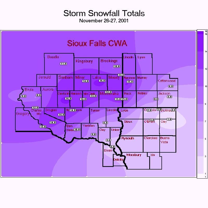