Sioux Falls, SD
Weather Forecast Office
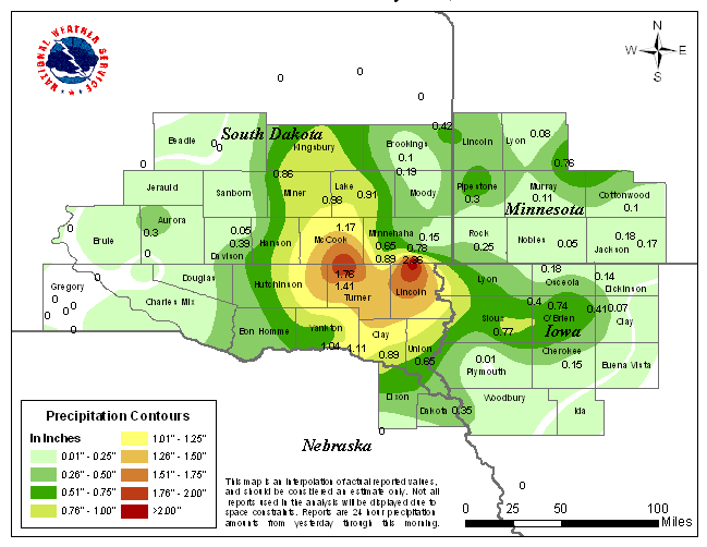
The map above shows where the rain was heaviest, and where some locations did not receive much rain at all the evening of July 27th through the morning of July 28th. Notice that much of the area between Salem South Dakota and Harrisburg South Dakota recieved more than an inch and half of rainfall. Some locations from central Sioux Falls through northern Lincoln county measured more than two inches. It was also rather wet toward the northwest up to around Carthage, and toward the east to around Sanborn Iowa, where amounts were mostly between a half and nine tenths of an inch.
Popular Pages
Past Weather Events
Regional Weather Roundup
Daily Temp/Precip
Hazardous Weather
Local Climate Archives
Climate Graphs and Data
Seasonal
EvapoTranspiration
Fire Weather
Grassland Fire Danger
Flooding (River)
Summer Weather
Travel Forecasts
Winter Weather
Winter Preparedness
Forecast Snowfall Graphic
Winter Temp Climatology

US Dept of Commerce
National Oceanic and Atmospheric Administration
National Weather Service
Sioux Falls, SD
26 Weather Lane
Sioux Falls, SD 57104-0198
605-330-4247
Comments? Questions? Please Contact Us.


 Weather Story
 Weather Map
 Local Radar
 Follow us on X
 Follow us on Facebook
 Follow us on YouTube
 FSD RSS Feed