Narrow bands of snow can occur anywhere in the United States. An excellent example of a narrow snowband occurred on November 20, 2015. Below is a plot of the snowfall across southeastern South Dakota and northern Iowa.
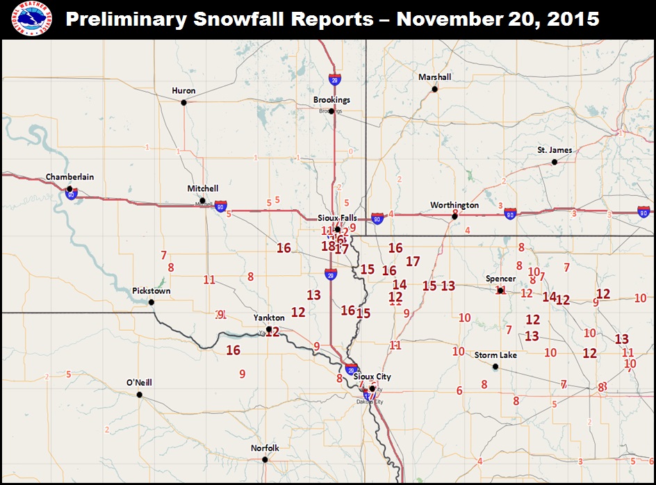
Notice the large difference (or gradient) in snowfall from south of Interstate 90 to north of Interstate 90. To the south of I-90, there was 12 to 18 inches of snow from the south side of Sioux Falls into far northwestern Iowa. North of Interstate 90, snowfall rapidly decreased to less than 6 inches, with no snowfall farther north toward Brookings and Marshall. In fact, over a distance of approximately 20 miles, snowfall increased from 2 to 4 inches, to 16 to 18 inches.
So why do the bands of heavy snowfall form? And how can such an extreme gradient in snowfall form?
There are three basic ingredients that are needed in the atmosphere to produce narrow bands of snow. They are:
1.) Moisture
This first ingredient is rather obvious. The atmosphere has to have enough moisture in the air to produce clouds and snow. If there is not enough moisture, then snow will not develop. For heavier snowfall, the atmosphere needs to continously bring moisture into the clouds so that snow continues to be produced and fall to the ground. The more effectively the atmosphere is able to bring moisture to the clouds, the heavier the snow may be.
2.) Front
A front is needed so that air is forced to rise in the atmosphere to produce clouds and snowfall. In summer, we typically look for fronts near the surface to produce thunderstorms. For narrow bands of snowfall, we are no longer looking at the surface for the front. Instead we look for fronts located between 3000 and 15000 feet above the ground. This forces air to be lifted in an area where the production of snow is most efficient. Near the surface, the atmosphere typically does a poor job forming snowflakes, but as one rises in the atmosphere and temperatures fall to 0ºF to -10ºF, snowfall production can occur more rapidly. So having a front located in the area where temperatures are in that range can force moist air to rise and quickly form snowflakes.
3.) Atmospheric instability
Atmospheric instability is needed to make the air rise even more quickly. The quicker the air rises, the more quickly snow forms in the clouds and the heavier the snowfall is at the surface. In summer, meteorologists talk about instability when looking for the development of thunderstorms. The instability associated with bands of heavy snow in winter is much less than in summer, so it is rare to see thunderstorms. For comparison, the typical thunderstorm has air rising well over 10 mph and in severe storms this can approach 100 mph. For the most intense snowbands, the air is rising around 2 mph. While much slower than a thunderstorm, this is still much higher than is typically seen in the atmosphere, and that speed is able to produce very heavy snowfall.
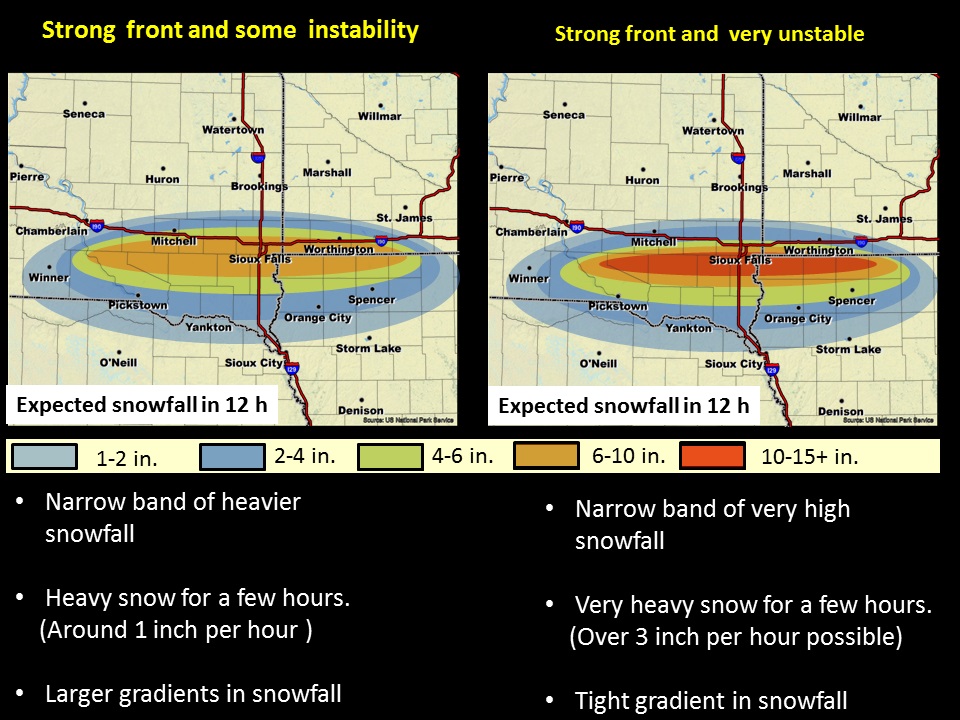
Atmospheric instability impacts bands of heavy snow in two ways. First, the less stable the atmosphere is, the faster the air rises and the heavier the snowfall. Second, the less stable the atmosphere is, the more narrow the band of snow is. Here are some examples.
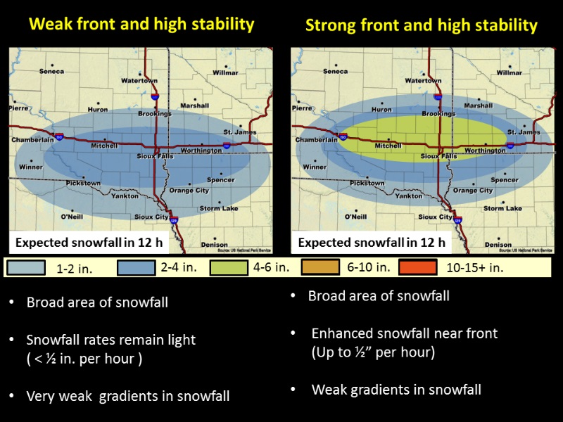
For the first example, there is the same atmospheric stability. The difference is that there is a weak front above the surface on the left and a strong front above the surface on the right. On the left, with both a weak front and high stability, there is a broad area of 2 to 4" of snow and as one goes from north to south, the amount of snow changes very slowly. Also the rate of snowfall is rather slow - typically much less than a half inch an hour. Looking at the right figure, there is a stronger front but also high stability. The stronger front will increase the lift so that there may be 6 inches in 12 hours and perhaps a half inch of snow per hour snowfall rate. But while there is a larger difference in snowfall from north to south, the change is still relatively little. For example, looking near Brookings, the snow fall ranges from 1 inch north of Brookings to around 4 inches south of Brookings. And the area of 4 to 6 inches covers a large area from Brookings to Sioux Falls.
Now let's look at what happens when we change the stability.


 Weather Story
 Weather Map
 Local Radar