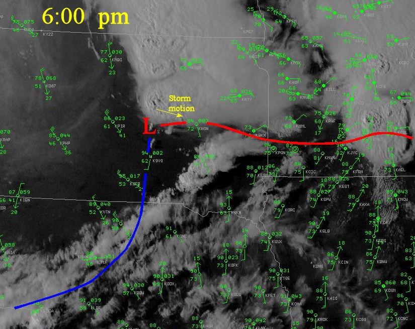
A tornadic thunderstorm moved across Beadle County, South Dakota between 6:30 pm and 8:00 pm on August 24, 2006. The type of thunderstorm that produced the tornadoes is known as a cyclic supercell. A supercell is a thunderstorm that has strong rotation on the inflow side of the storm called a mesocyclone, and is responsible for most of the strong tornadoes (F2 or greater) and very large hail that affects the United States. A cyclic supercell is one in which the mesocyclone occludes, i.e. the cold air from the outflow of the thunderstorm surrounds the mesocyclone, and a new updraft and mesocyclone form on the inflow side of the storm. In some cases, these mesocyclones will produce a new tornado. The radar discussion below will follow the supercell into Beadle County, until it exits into Kingsbury County around 7:50 pm. During this time, the primary mesocylcone will mature, produce a tornado that tracks from 24 miles from west of Wessington, South Dakota, to southwest of Huron, SD. This tornado was rated F3. Then a second mesocyclone forms to the southeast of the original mesocyclone, and produces a tornado that tracked south of Cavour, SD. This tornado was rated F2.
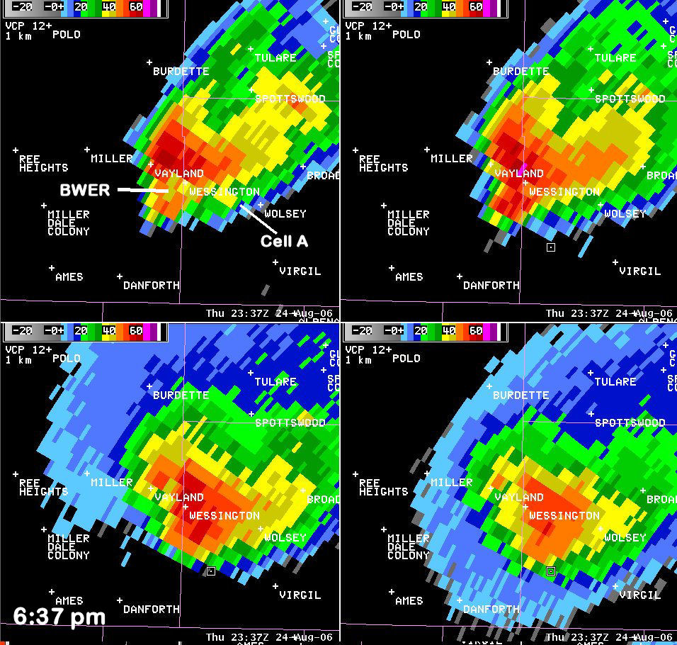
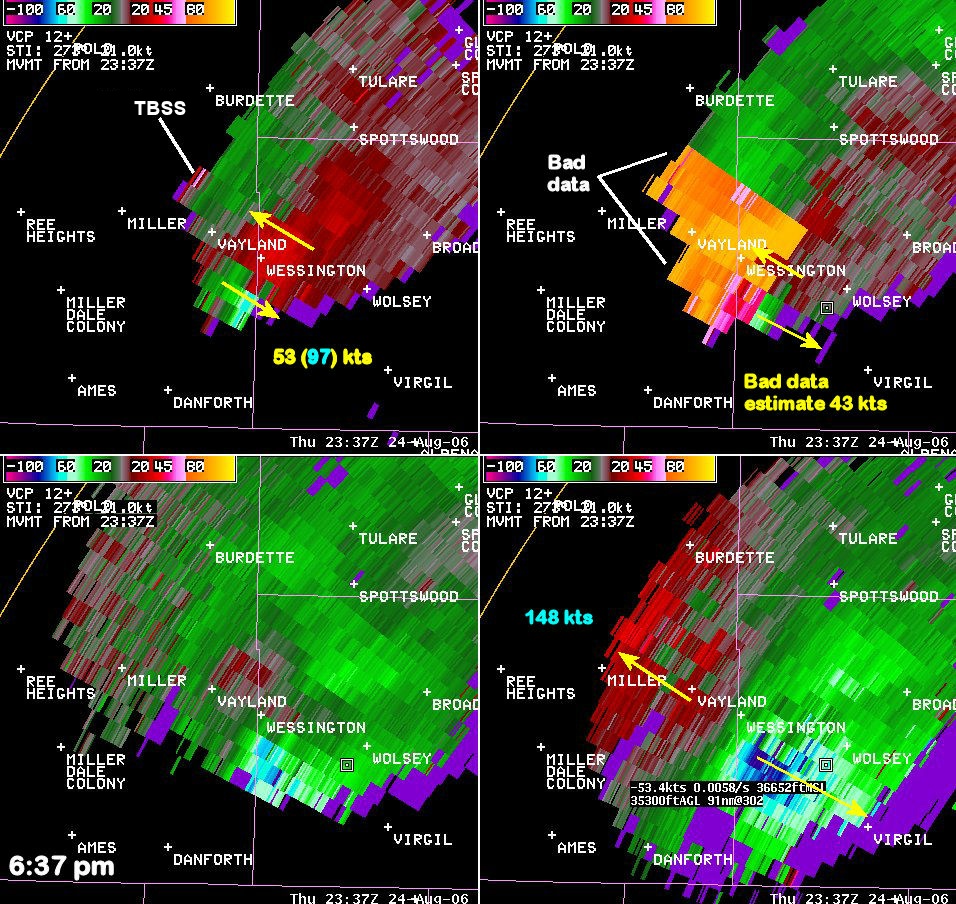
Both reflectivity and storm relative motion (SRM) will be examined in the images below. Reflectivity measures the amount of rain (or hail) that is within the storm, the stronger the reflectivity the heavier the rain (or hail) that is falling. Storm relative motion measures the wind velocity coming toward (green on image) or away (red on image) from the radar. To make circulation easier to see SRM subtracts out the storm motion of the detected wind velocity so that a more balanced circulation is observed. For both SRM and reflectivity, 4 panel images will be shown. In the upper left will be the 0.5 degree slice of the radar scan, in the upper right 1.5 degrees, in the lower left is 2.4 degrees, and in the lower right is 3.4 degrees. You can click on any of the radar images below for a larger view.
The supercell was crossing from Hand into Beadle County near Wessington, SD at 6:37 pm CDT. At this time, the tornado was 0.25 miles wide and had F2 strength. At 0.5º (upper left of 4-panels), a bounded weak echo region (BWER) was evident west of Wessington. A BWER occurs when the updraft prevents significant precipitation (rain or hail) from falling through it. At the same time, the mesocyclone bring rain and hail around the south and east side of the updraft which results in a “hole” of lower reflectivity. Presence of a BWER is indicative of a very strong rotation and very strong updraft. One can verify that this is a BWER and not a spurious return by looking at SRM. The mesocyclone, with a rotational velocity of 53 kts, is coincident with the BWER at 0.5º. Unfortunately bad data at 1.5º prevent an examination of the mesocyclone at this level. Also notice that at 1.5º, the reflectivity is much higher above the BWER at 0.5º.
At 0.5º, there is evidence of a storm merger. A weak cell which formed earlier on the cold front has merged with the forward flank of the storm.
There are also weak reflectivity returns that extend northwest of the high reflectivity (north of Wayland). From the reflectivity image alone, it is difficult to tell if this is a three-body scatter spike (TBSS) which can be indicative of large hail. However, a look at SRM shows weak outbound velocity at this same point. The subtraction of the storm motion will result in weak outbound velocity when the actual (ground-based) velocity is near zero which would strongly support the inference of a TBSS and the presence of large hail. Note that at 1.5º there is also reflectivity >65 dBz (purple colored return). The storm top divergence found at 3.4º (maximum inbound velocity + maximum outbound velocity near the storm) is near 150 kts, and also indicates large hail is likely present.
Finally, notice that at all 4 levels there is little if any reflectivity to the southeast of the storm. This supports what was seen on satellite. There is little cloud cover above the inflow of the updraft allowing very unstable air to continue to come into the storm.
 |
 |
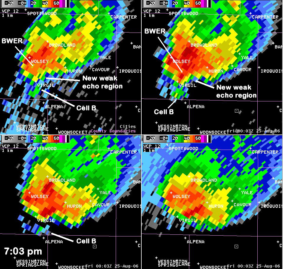
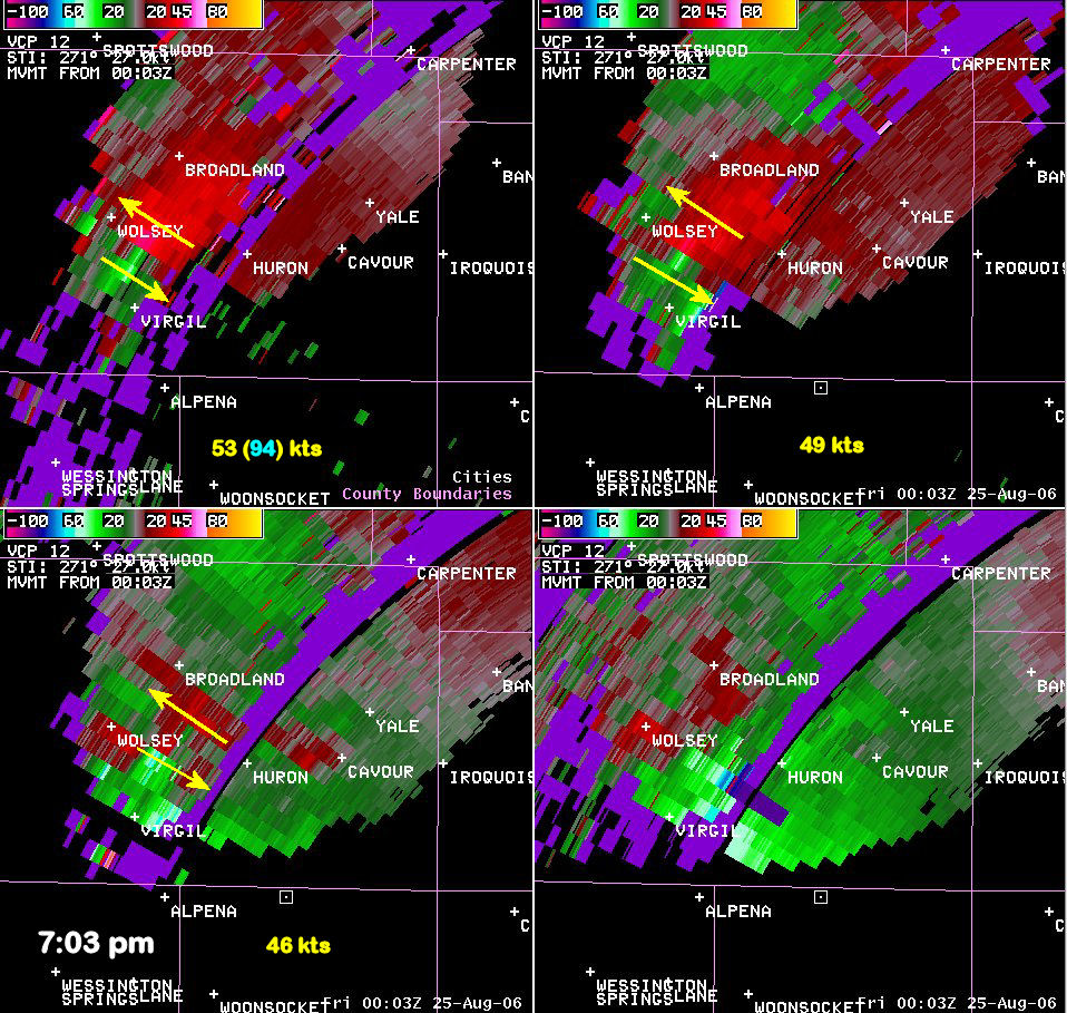
The tornado was located 2 miles south-southeast of Wolsey. Based upon the damage survey, the tornado had been at its strongest when it was 2 miles south of Wolsey at 7:01 pm. At this time, the tornado had winds near 200 mph making a strong F3 tornado. A BWER is evident at 0.5º and 1.5º to the southeast of Wolsey. This is coincident with a very strong mesocyclone (53 (49) kts rotational velocity at 0.5º (1.5º)). The gate-to-gate shear (the largest difference between adjacent pixels along the same azimuth) was 94 kts which is well above the criteria for a tornado vortex signature (TVS) this far from the radar. While the radar is not the tornado’s own rotation, this is an intense rotation within the mesocyclone that can be indicative of tornado formation. There is also evidence of a new updraft beginning to form to the southeast of the BWER. Both 2.4º and 3.4º have a maximum of reflectivity east of Virgil with little reflectivity observed at 0.5º and 1.5º. There is a secondary maximum in reflectivity near Wolsey and over the BWER. Downwind of this secondary maximum between Wolsey and Huron, is likely where any large hail was occurring. Finally, note the weak cell forming south of Virgil. This cell was moving to the northeast and approaching the supercell.
 |
 |
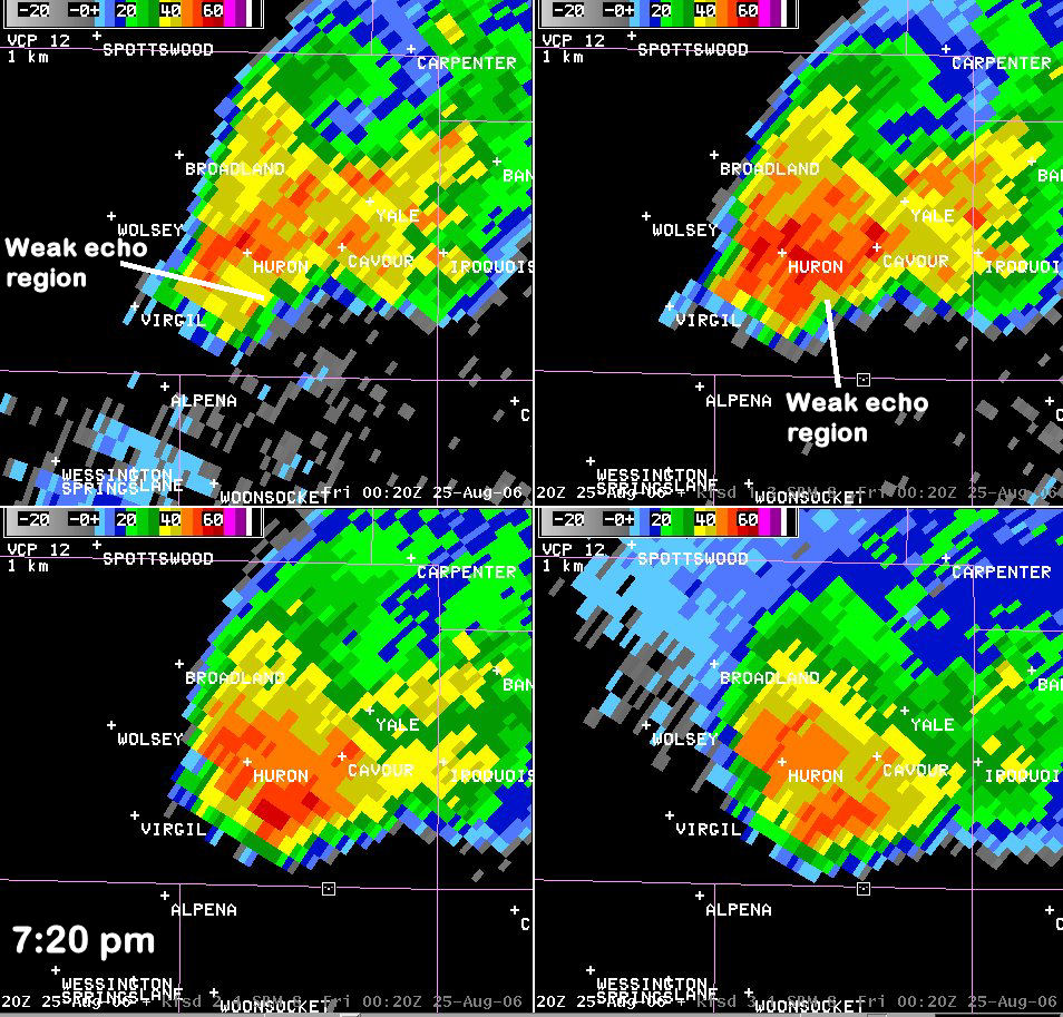
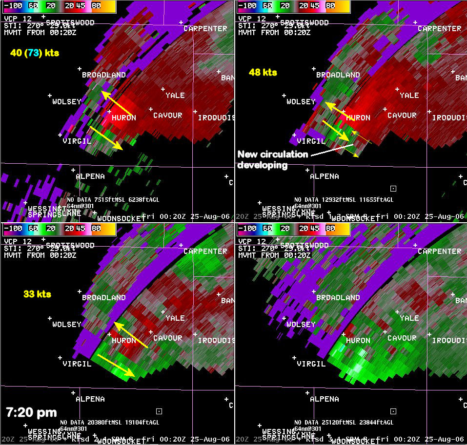
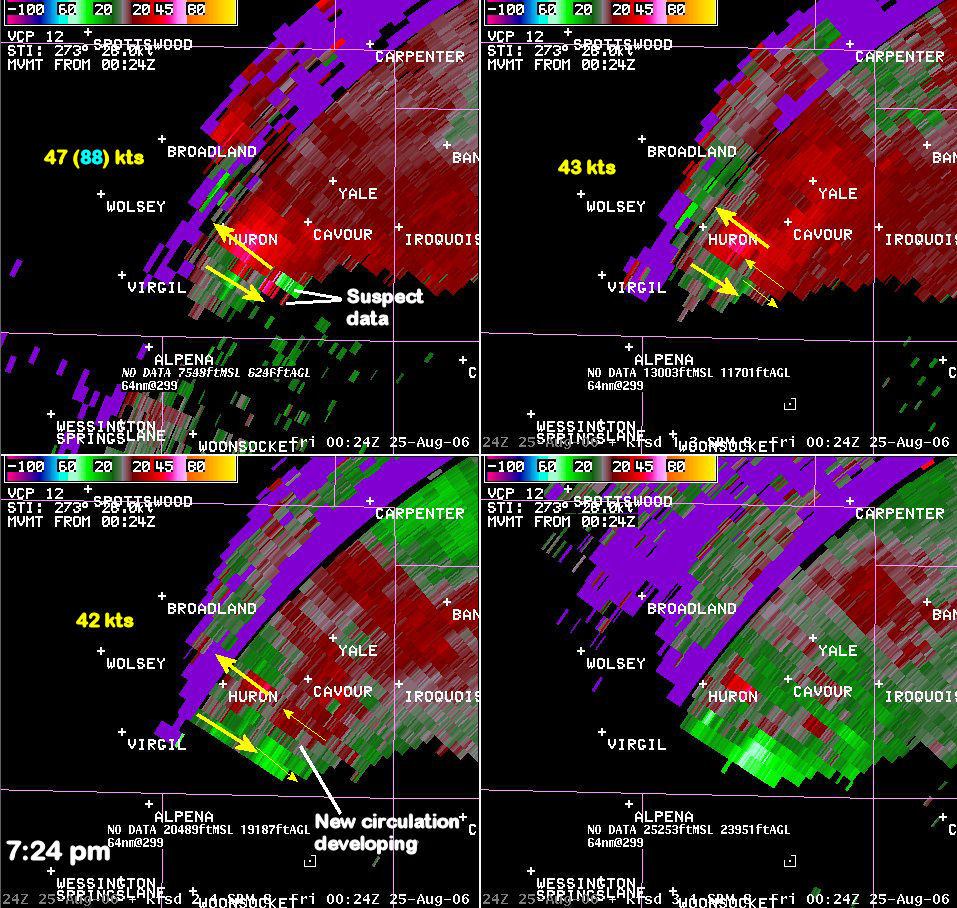
The tornado that hit Wessington and Wolsey had weakened to F1 at this point and by 7:22 pm CDT would dissipate. Meanwhile at 7:18 pm CDT, a new tornado formed 3 miles southeast of Huron. This is coincident with the new updraft that had formed east of Virgil around 7:00 pm CDT. In the reflectivity imagery, it has become the primary updraft as the highest reflectivity at 2.4º and 3.4º is now southeast of Huron. A weak echo region is evident at 0.5º and 1.5º in this same area. The original mesocyclone has become less organized to the southwest of Huron with only the remnants of a weak echo region at 0.5º southwest of Huron. Even though the reflectivity signature shows the new updraft becoming predominant, the SRM imagery shows that the primary mesocyclone has the strongest rotational velocities with greater than 40 kts above 1.5º and 30 kts at 2.4º. The new updraft has also begun to rotate with weak rotation observed at 2.4º.
 |
 |
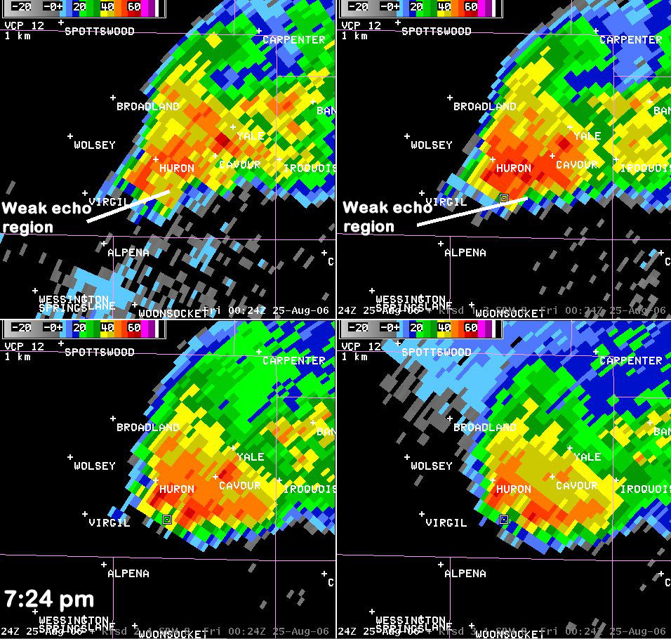
The tornado continues to develop south of Cavour. At the same time, a rope tornado formed southwest of Huron at 7:23 pm CDT. The tornado south of Cavour was associated with the mesocyclone that was reorganizing southeast of Huron. The circulation with the original mesocyclone began to strengthen rapidly with rotational velocity exceeding 40 kts and 88 kts of gate-to-gate shear. The secondary circulation has deepened and is evident at 1.5º and 2.4º. Meanwhile, at 0.5º, the circulation appears to be anticyclonic. However, the speed in both of the inbound and outbound does not correlate well with nearby pixels. Large inbound velocities are adjacent to weak outbound resulting in an unrealistic gradient along the same radial. These velocities have been labeled as bad data and, based on data at subsequent times and also at higher levels, it is hypothesized that a cyclonic circulation actually exists in this area but the sudden appearance of this circulation at 0.5º led to problems with the dealiasing algorithm in assigning the correct velocity. As the mesocyclone continues to organize, a significant weak echo region has developed.
 |
 |
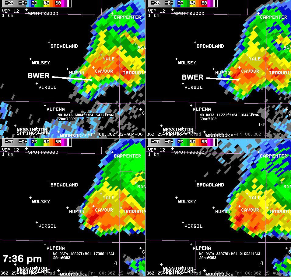
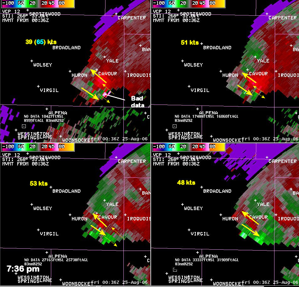
The tornado was located approximately 7 miles south of Cavour between 7:33 and 7:38 pm CDT. The tornado was strongest at this point reach F2 intensity and a width of 300 to 400 yards. The primary circulation has reorganized and become dominant by this time. A BWER has formed at 0.5º and 1.5º south of Cavour. At 0.5º, the higher reflectivity was beginning wrap around the south side of the mesocyclone giving a hook appears to the reflectivity. Meanwhile, the strongest circulation at 1.5º, 2.4º, and 3.4º was coincident with the BWER. The rotational velocity once again exceeded 50 kts. A second circulation continues to be evident southeast of the strongest east circulation south of Cavour. However, this circulation has become more shallow and is not evident above 1.5 degrees.
 |
 |


 Weather Story
 Weather Map
 Local Radar