
A heat wave over the Southwest will intensify this week, peaking and expanding into the Intermountain West and northern High Plains this weekend. Severe thunderstorms and heavy rainfall are expected over parts of the Upper Midwest to mid-Mississippi Valley today. Critical to extremely critical fire weather conditions from the Northwest and the northern Great Basin on Saturday and Sunday. Read More >
|
Supercell Thunderstorms Create Swath of Damage and Injury
|
|
A lone supercell thunderstorm developed around 3 pm southeast of Claremont, in Kent County. The storm quickly became severe, producing nickel sized hail. A few minutes later, south of Aspermont (Stonewall County), the storm produced its first tornado. Large hail was reported with this storm as well. The supercell storm continued to move east where it again produced a brief tornado in southern Throckmorton County. Very large hail continued with this storm as it continued to move east along a stalled surface boundary. The next tornado occurred in northern Palo Pinto county at 6:20 pm. Four inch hail accompanied the storm at this time. Continuing to propagate along the surface boundary, the storm moved into the western metroplex where it packed baseball sized hail. At approximately 7:40 pm, a couple of tornadoes briefly touched down in North Richland Hills (Northeast Tarrant County).
At least 3 people were injured by the large hail that fell during this event, and numerous roofs, gutters, windows, airplanes, automobiles, and trees were damaged. The damage cost from these storms will likely continue to rise over the coming weeks and months.
Photo of 3 inch hailstone that fell |


 April 5th, 2003 may go down in history as one of the costliest hail storm events ever in the United States!
 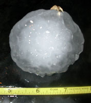 Three inch hail also pummeled northeast Tarrant County. New supercell storms formed behind the main storm that originated in west Texas, however, no more tornadoes were found from the series of supercells that moved over the metroplex. Large hail (larger than baseballs) did continue with the storms as they moved further east. Four and a half inch hail fell in far northern Rockwall County. The large hail swath ended around 10:50 pm, west of Sulphur Springs (Hopkins County), where 1.75 inch hail fell.