| Remembering Delta Flight 191 |
 |
| Credit: Dallas Morning News |
Introduction |
| The Delta Air Lines Flight 191 airplane crash at Dallas/Fort Worth International Airport (DFW) occurred around 6:05 P.M. CDT on August 2, 1985. The National Transportation Safety Board's (NTSB) Accident Board determined that the cause of the incident was wind-shear associated with an intense thunderstorm downdraft that occurred at the north end of the airport along runway 17 Left (17L). Today we know this intense, localized downburst as a microburst, a weather phenomenon that was not well understood at the time of the accident. For information on an intense, but slightly larger downburst, see macroburst. The table below lists several aircraft incidents in which weather played a major role or was the direct cause for the loss of life and/or the loss of the airplane. The Delta Air Lines Flight 191 accident marked the 3rd event between 1975 and 1985 in which more than 100 fatalities occurred in an aircraft incident due to a microburst in the United States. The events on August 2, 1985, as well as other dates (see table below) likely helped to drive the need to reform aviation weather safety. These needs included the improved the detection of hazardous weather to aircraft using remote sensing instruments, equipping pilots and aircraft with tools to identify weather hazards to aircraft and continued collaboration between the National Weather Service (NWS) and Federal Aviation Administration (FAA). |
Weather Related Commercial Airline Incidents in the U.S. |
| Flight | Date | Crash Location |
Destination | Weather Hazard |
Number of Fatalities |
| Capital Airlines 20 | 1/18/1960 | Charles City, VA | Norfolk, VA | Aircraft Icing | 50 |
| Northwest Airlines 705 | 2/13/1963 | Florida Everglades |
Portland, OR | Thunderstorm (Turbulence) |
43 |
| Pan American World Airways 214 |
12/08/1963 | Elkton, MD | Philadelphia, PA | Thunderstorm (Lightning) |
81 |
| Eastern Air Lines 66 | 6/24/1975 | NYC | NYC | Thunderstorm (Microburst) |
113 |
| Southern Airways 242 | 1/04/1977 | New Hope, GA | Atlanta, GA | Thunderstorm (Hail) |
62 |
| Air Florida 90 | 1/13/1982 | Washington D.C. | Fort Lauderadale, FL | Aircraft Icing | 70 |
| Pan American World Airways 759 |
7/09/1982 | Kenner, LA | Las Vegas, NV | Thunderstorm (Microburst) |
153 |
| Delta Air Lines 191 | 8/02/1985 | Grapevine, TX | Los Angeles, CA | Thunderstorm (Microburst) |
137 |
| Continental 1713 | 11/15/1987 | Denver, CO | Bosie, ID | Aircraft Icing | 28 |
| US Air 405 | 4/22/1992 | NYC | Cleveland, OH | Aircraft Icing | 27 |
| US Air 1016 | 7/2/1994 | Charlotte, NC | Charlotte, NC | Thunderstorm (Microburst) |
68 |
| American Airlines 4184 | 10/31/1994 | Roselawn, IN | Chicago, IL | Aircraft Icing | 68 |
| Comair 3272 | 1/09//1997 | Monroe, MI | Detroit, MI | Aircraft Icing | 29 |
| American Airlines 1420 | 6/01/1999 | Little Rock, AR | Little Rock, AR | Thunderstorm (Poor Visibility) |
11 |
| Colgan Air 3407 | 2/12/2009 | Buffalo, NY | Buffalo, NY | Aircraft Icing | 50 |
| Events here are compiled from FAA and NTSB reports. This is NOT an exhaustive list and there are likely other events not listed! |
| Numerous reports, documentaries and reports have been completed following the events on August 2, 1985. Of particular interest is the official FAA/NTSB Report on the incident. The focus of this webpage will be to detail meteorological conditions that resulted in the development of showers and thunderstorms near the DFW International Airport that likely resulted in the loss of Delta Air lines Flight 191. In addition, a brief look at some of the new forecast methodologies and technology that was developed is discussed. |
Meteorological Overview |
|||
|
The national surface map on the morning of August 2, 1985, at 7:00 A.M CDT revealed that a cold front extended from the east coast back into the southern plains. The figure (to the left and in the link) are courtesy of the National Oceanic and Atmospheric Administration (NOAA) Library. For a larger image of the surface map, click here or on the image itself. Temperatures at 7:00 A.M. CDT were already quite mild with readings in the upper 70s ahead of the southward moving cold front. Cold fronts are not too common during this time of year, due to the lack of strong temperature contrasts that drive these features. Oftentimes, the lack of any appreciable cloud cover and/or precipitation results in sufficient modification of the air mass behind the front. This in turn decreases the horizontal temperature contrast and thus effectively weakens the front. However, in the case of August 2, 1985, the widespread cloud cover and light rain behind the front (as noted by observations at Oklahoma City, Tulsa and Fort Smith [not shown]) kept afternoon temperatures fairly cool for the summertime (readings in the 80s and low 90s). The areas of scattered clouds and light precipitation likely served to reinforce this temperature contrast. The Weather Service Meteorological Observatory (WSMO) at Stephenville, TX, was responsible for radiosonde observations during this era of the NWS. The radiosonde observation was taken twice daily (1200 UTC [7:00 A.M. CDT] and 0000 UTC [7:00 P.M. CDT]). On the morning of August 2, 1985 (left panel in figure below), the radiosonde data revealed modest instability, but very weak vertical wind shear, something fairly usual for the summer. With daytime heating, the lowest several thousand feet of the atmosphere heat up and convective currents develop. These convective currents tend to "mix" the atmosphere and result in a decrease in the moisture content and an increase in the temperature near the surface. This is manifest in the increase in the theoretical cloud base height as can be seen when comparing the 1200 UTC (theoretical cloud base of 4,900 feet) and 0000 UTC (theoretical cloud base of 10,000 feet) data. Unknown to scientists at the time, the temperature and moisture profile plotted on a diagram such as a Skew-T Log P as seen in the right panel in the figure below, is actually favorable for microbursts (dependent on whether a sufficiently strong shower or thunderstorm develop).
|
| Daytime temperatures to the south of the cold front across north and central Texas climbed into the upper 90s and even up to 101°F at DFW. The daytime heating combined with low level moisture resulted in the development of afternoon cumulus clouds across much of north and central Texas. Through the afternoon, temperatures increased with daytime heating and areas of afternoon clouds began to develop as evidenced by routine weather observations seen in the table below. Several hours before the incident, a few observations of cumulonimbus and towering cumulus clouds were reported by the weather observer at DFW International Airport. Visible satellite imagery by the late afternoon hours revealed that mature thunderstorms were already ongoing along the frontal boundary with areas of towering cumulus in and around the DFW Metroplex. Through much of the afternoon, mostly sunny skies persisted and winds were generally light and variable. Dr. Ted Fujita obtained archived satellite imagery during this time and these are annotated in the figures below. Note that areas along the frontal boundary (near and just south of the Red River) are likely characterized by higher instability values due to deep moist convergence along the frontal zone. Based on the position of convection during the late afternoon hour via satellite imagery (see below), it is possible that the frontal zone lifted slightly to the north--especially if thunderstorm outflow was sufficiently strong. Regardless, the daytime heating and enhanced moisture convergence along the front likely resulted in sufficient instability for a rather impressive satellite presentation of deep moist convection. As noted above, this convection likely produced numerous outflow boundaries that served to induce lift and result in the development of additional thunderstorms farther towards the southwest near the DFW Metroplex. |
Visible Satellite Imagery on August 2, 1985 |
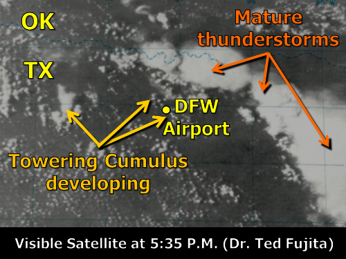 Visible Satellite Imagery at 5:35 P.M. CDT |
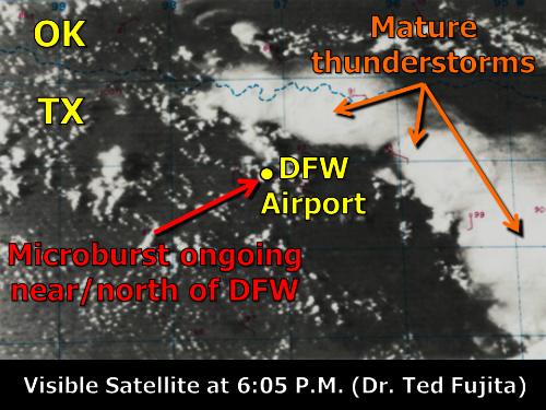 Visible Satellite Imagery at 6:05 P.M. CDT |
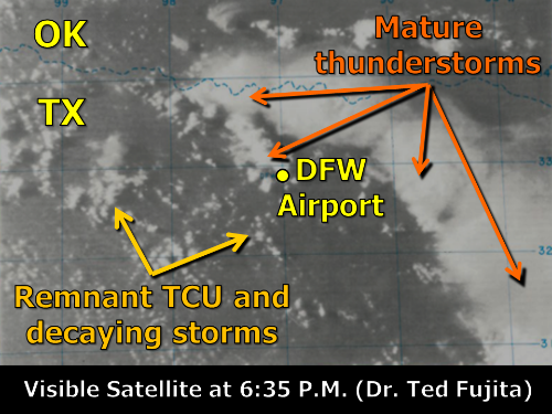 Visible Satellite Imagery at 6:35 P.M. CDT |
| Click one of the above thumbnails for a larger image |
Weather Observations at DFW Intl. Airport on August 2, 1985 |
| Time | Sky & Wx Condition |
Temperature (°F) |
Temperature (°F) |
Wind Speed (M.P.H) |
Wind Direction (°) |
Weather Remarks |
| 12:00 PM |
Mostly Sunny |
95°F | 68°F | 6 M.P.H. | South (190°) | None |
| 1:00 PM |
Partly Cloudy |
98°F | 67°F | 6 M.P.H. | East (100°) | Developing Moderate Cumulus (MDT CU) |
| 2:00 PM |
Partly Cloudy |
96°F | 67°F | 9 M.P.H. | South-Southwest (220°) | Towering Cumulus (TCU) |
| 3:00 PM |
Partly Cloudy |
100°F | 66°F | 5 M.P.H. | West (260°) | Cumulonimbus (CB) NE of DFW |
| 4:00 PM |
Partly Cloudy |
100°F | 67°F | 6 M.P.H. | South-Southwest (220°) | Towering Cumulus all around DFW (TCU ALQDS) |
| 5:00 PM |
Partly Cloudy |
100°F | 65°F | 7 M.P.H. | South-Southwest (210°) | Cumulonimbus N of DFW & Towering Cumulus (CB N & TCU) |
| 6:00 PM |
Mostly Cloudy |
101°F | 65°F | 9 M.P.H. | East-Southeast (120°) | Cumulonimbus N/NE of DFW & Towering Cumulus (CB N-NE & TCU) |
| 6:05 PM |
Mostly Cloudy |
N/A | N/A | 9 M.P.H. | East-Northeast (70°) | Thunderstorm N/NE of DFW & moving S |
| 6:14 PM |
Cloudy | N/A | N/A | 42 M.P.H (53 M.P.H. gust) |
North (360°) | Thunderstorm N/NE of DFW & moving S |
| 6:26 PM |
Thunderstorm w/Rain |
N/A | N/A | 58 M.P.H (80 M.P.H. gust) |
West-Northwest (300°) | Thunderstorm N of DFW & moving S |
| 7:00 PM |
Thunderstorm | 88°F | 68°F | 11 M.P.H. | North-Northeast (20°) | Peak Wind gust of 70kt at 300° from the WNW at 6:25 PM (PKWND 3070/25) |
| As seen in the satellite imagery, most of the convection near the DFW area "appeared" relatively benign, compared to convection along the Red River (as inferred from the visible satellite presentation). A brief radar tour of convection near the DFW Metroplex will be examined next. |
Stephenville Radar Imagery |
| During this time period, the NWS was comprised of NWS Weather Service Forecast Offices (WSFOs), Weather Service Offices (WSOs) and Weather Service Meteorological Observatories (WSMOs). One of the main roles for individuals at WSMOs often was to manually operate and interpret radar data from the 1957 Weather Surveillance Radar (WSR-57). While these radars provided the ability to determine the location, and to some degree, the intensity of precipitation echoes, it was oftentimes difficult to determine wind intensity associated with these echoes from radar alone. Through the 1990s, the NWS, FAA, and the Department of Defense (DoD) upgraded and installed Doppler Radars (WSR-88Ds) across the country. Doppler Radars have the ability to determine not only the intensity (related to the size of the object) of the target, but it has the capability to determine target motion (and inferred associated wind speeds). The WSR-57 located at the WSMO in Stephenville did identify developing precipitation echoes near and north of the DFW International Airport. The Stephenville radar is located approximately 80 miles (70 nautical miles) to the southwest of DFW International Airport. Radar imagery during the 80s and 90s was displayed using a Video Integrator Processor (VIP). There were six levels in which echoes were classified (Weak, Moderate, Strong, Very Strong, Intense and Extreme). Archived radar imagery for this event begins at around 5:28 P.M. CDT and lasts through 6:17 P.M. CDT. |
5:28 P.M. CDT Stephenville Radar Imagery |
| Some convection (CU and TCU) were observed near DFW around 5:00 P.M. CDT from the Stephenville radar. This activity was likely remnants from old decaying thunderstorms in the area. By 5:28 P.M. CDT, new radar echoes began to intensify north of DFW. In some cases, the "newer" echoes were often than the parent echo as air was likely rapidly forced upward along outflow boundaries. At this time, the radar specialist at the Stephenville WSMO noted that the strength of the precipitation echo near the runway could be classified as category VIP 1 ("weak echo"). The weather observer at DFW International Airport reported cumulonimbus clouds to the north of the airport as these echoes began to mature at the 5:00 P.M. CDT observation. The movement of these echoes was very slow to the south and southwest due to the absence of strong mid or upper level winds as seen in the visible satellite and radar imagery. If one compared the first two radar images, one can clearly see little in the way of horizontal displacement between the two echoes. This is indicative of a very slow storm motion. At this time, Delta Air Lines Flight 191 continued towards DFW Airport by way of the Blue Ridge VOR just east of present-day Melissa, TX. |
5:48 P.M. CDT Stephenville Radar Imagery |
| The radar imagery (seen below) during this time now showed a black "speck" or "hole" in the southwestern-most cell, likely indicating that cell intensity has increased to VIP 3 or into the "Strong" category. Similarly, observers at DFW International Airport had been reporting areas of moderate cumulus, with even a few remarks about thunderstorms building in the area over the past hour. Satellite imagery around 15 minutes before also suggested areas of towering cumulus ahead of the main convective complex along the Red River. During this time, flight crew aboard Delta Air Lines Flight 191 could visually observe convective activity near Fort Worth after they had detoured around convection near Texarkana. |
Stephenville Radar Imagery |
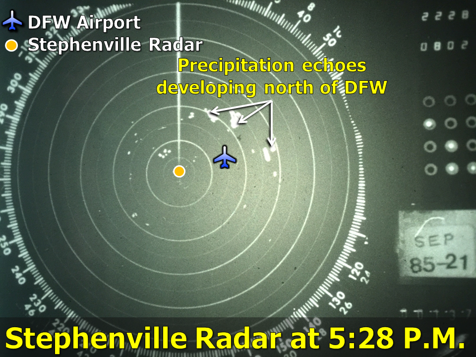 Stephenville WSR-57 Radar imagery at 5:28 P.M. CDT |
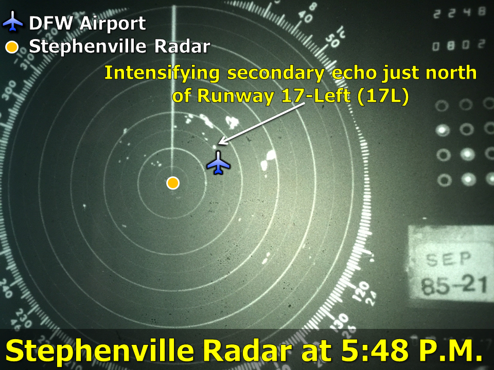 Stephenville WSR-57 Radar imagery at 5:48 P.M. CDT |
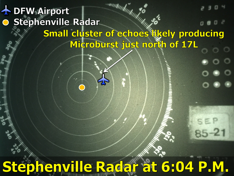 Stephenville WSR-57 Radar imagery at 6:04 P.M. CDT |
| Click one of the above thumbnails for a larger image |
6:04 P.M. CDT Stephenville Radar Imagery |
| By 6:00 P.M. CDT, moments before the crash, the radar imagery showed two distinct cells adjacent to one another---each showing strengths of VIP 3 or "Strong" intensity around 2-4 miles north of runway 17L, Delta Air Lines Flight 191's intended target. During this time, several observers reported hearing thunder from this activity and the co-pilot of the aircraft noted lightning. While winds were reported to be "relatively calm" at the observation site near the center of DFW International Airport, a microburst with winds in excess of 80 M.P.H. was likely beginning to develop with the precipitation echoes just north of runway 17L, likely unknown to anyone. Information from the Low Level Wind Shear Alert System (LLWAS) located just north of the location of the observer recorded a wind gust of 46 knots (53 MPH) just a few minutes after Delta Air Lines Flight 191 reportedly exited the rain curtain associated with the convective cell. Here is a wind trace from the anemometer at DFW. The figure was obtained by Dr. Ted Fujita. Based on information from the flight data recorder, it would appear that Delta Air Lines Flight 191 likely traversed a region in which rain, lightning and very turbulent winds were occurring. Just a minute or two after this radar image was taken, the DFW International Airport observer reported a thunderstorm to the north and northeast of their location as noted in the table of official observations and encodes and transmits a non-routine special observation at 6:05 P.M. CDT Visible satellite imagery at this time also showed a few thunderstorms in the vicinity of DFW International airport. Even still, the true microburst was not recorded at the observation site. A very different scene was likely unfolding, however, only a mile or two north of the observation site. The region north of runway 17L was likely experiencing tremendous amounts of wind. |
The Crash |
| At 6:05 P.M. CDT Delta Air Lines Flight 191 crash landed just short of runway 17L, striking a vehicle on Texas State Highway 114 after emerging from precipitation that was heavy enough to enshroud the aircraft. According to eyewitness accounts, after the plane struck the vehicle on highway 114, it "rebounded" and then slammed into the ground. The airplane then struck a couple of large water tanks located on the north-side of DFW International Airport. The impacts with the ground and the water tanks resulted in a large fireball which consumed a majority of the airplane. Twenty-six people survived the crash (mainly those seated in the aft of the plane), but tragically 137 people lost their lives. |
|
The figures below (courtesy of the Star-Telegram [Fort Worth, TX] and Dallas Morning News [Dallas, TX]) reveal the remains of the aircraft after crash landing at DFW.
|
 Aft section of Delta 191 post-crash landing at DFW. Credit: Dallas Morning News |
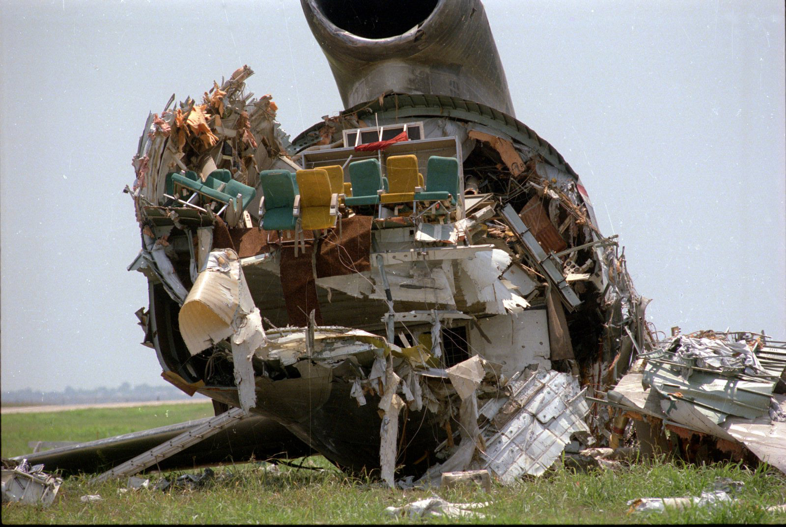 Interior of aft section of Delta 191. Credit: Star-Telegram |
| Click one of the above thumbnails for a larger image |
Imagery from the Stephenville radar indicates that the weather echoes have likely decreased from VIP 3 or "strong" perhaps downward to VIP 1 ("weak") or 2 ("moderate"). While a slight weakening of the echo may have been observed, it is likely that very strong winds are continuing across the northern sides of DFW airport. Due to the non-Doppler capabilities and the distance between the Stephenville radar and the precipitation echoes, sampling the magnitude of these strong winds would have been virtually impossible. It does appear plausible that an additional core of very strong winds barreled through the north side of DFW and over the crash site of Delta Air Lines Flight 191 during this time. Moreover, the weather observer contractor transmitted another non-routine weather observation at 6:14 P.M. CDT which revealed a rapid increase in winds of up to 42 M.P.H. with wind gusts to 53 M.P.H. These winds are likely on the leading edge of a core of the microburst that downed Delta Air Lines Flight 191. The strongest core of winds appeared to have arrived at the observation site at DFW 8 minutes later (6:25 P.M) when the observer recorded an 80 M.P.H wind gust. By 6:35 P.M., visible satellite imagery reveals only a few remnant areas of showers and perhaps towering cumulus clouds.
Prior to the Delta Air Lines Flight 191 incident at DFW International Airport the field phase of a research project, the Joint Airport Weather Studies (JAWS) aimed at studying microbursts had just completed. The JAWS project, however, targeted mainly dry microbursts across the high plains of Colorado. A new project, the MIcroburst and Severe Thunderstorm (MIST) experiment, would look at environments supportive of wet microbursts. This project occurred during the summer of 1986 and examined convection across the southeast United States. Research from both JAWS and MIST revealed that certain thermodynamic environments lend themselves to two primary classes of microbursts: wet and dry. These classes are a product of processes that drive or enhance the downdraft of the thunderstorm, the environment in which the downdraft formed and the amount of precipitation produced at the surface. Dry microbursts develop as precipitation particles either melt or evaporate below the very high cloud base. Melting or the subliming of ice particles or the evaporation of liquid particles can help to drive a very strong downdraft. As the name implies, little to no precipitation occurs with dry microbursts. Conversely, wet microbursts can form when very dry air at mid levels is mixed with the moist air along and inside the cloud. This results in evaporation necessary to create a strong downdraft. Precipitation amounts of at least one-tenth of an inch or greater typically accompany wet microbursts. In addition, a third class of known as "hybrid" microbursts has often been used to characterize microbursts that exhibit characteristics of both wet and dry microbursts. The figure below summarizes key findings from the data collected via various research projects (e.g., JAWS and MIST).
Conceptual Microburst Models |
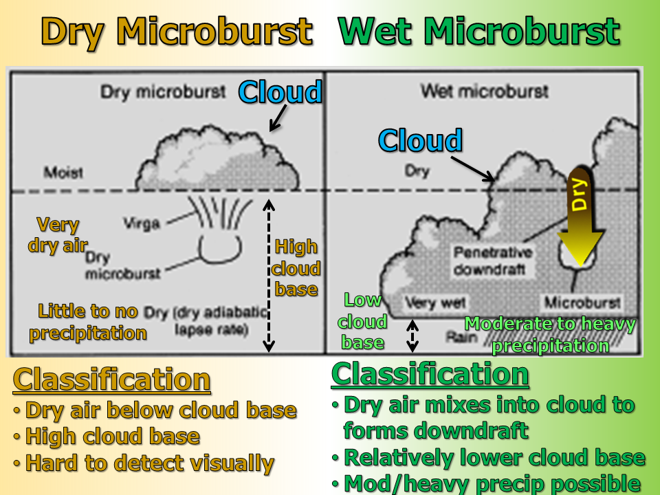 Conceptual model of dry (left) and wet (right) microburst. Figure adapted from Wakimoto and Atkins (1991) |
From the figure above, it was theorized that the factors that drive or enhance the thunderstorm downdraft are related to the melting or evaporation of precipitation particles(hail/graupel or rain) below the cloud base (dry microburst) or entrainment of dry air into the convective cloud, creating cooler denser air that sinks rapidly through the cloud. Thermodynamic diagrams (Skew-T Log P) were determined to be very useful in determining whether or not conditions are favorable for microbursts. In addition, Wakimoto and Atkins (1991) examined various thermodynamic diagrams (Skew-T Log P) and plots of Equivalent Potential Temperature or theta-E to diagnose environments favorable for microbursts. The figures below are plots that essentially summarize the data gathered from radiosondes during the MIST project. The project determined that environments for microburst were often characterized as those having very weak deep layer wind shear and weak to modest instability. In addition, this difference in "theta-E" is thought to be important for the development of a strong downdraft. This difference can be maximized when low theta-E air exists at mid levels, while large amounts of high theta-E air is located in lower levels of the atmosphere. As seen in the composite profiles, morning soundings on "microburst days" usually exhibit a fair amount of low level stability as noted by the bulge in the temperature (solid black line in panel A) and theta-E (solid black line in panel B) towards the right side of the figure. Composite soundings from MIST revealed that afternoon "microburst days" were characterized by a low level temperature and moisture profile that exhibited an upside down V or "inverted V" and a sufficient difference in mid- and low-level theta-E values as seen in panels C and D, respectively. During the MIST project, it was determined that a 20K difference in theta-E was a good discriminator between microburst and non-microburst days (assuming conditions are favorable for convection).
Idealized Soundings and Theta-E profiles for Microbursts |
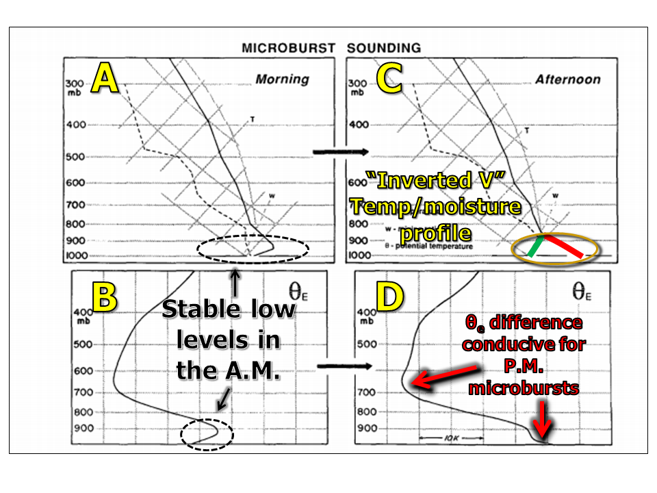 A/B show typical Skew-T & Theta-E vs. pressure profiles on the A.M. of a "microburst day" C/D show typical Skew-T & Theta-E vs. pressure profiles on the P.M. of a "microburst day". |
Observed Soundings and Theta-E profiles from Stephenville, TX
|
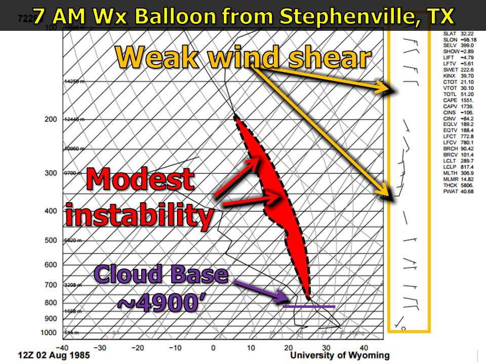 12 UTC (7:00 A.M. CDT) data from Stephenville, TX |
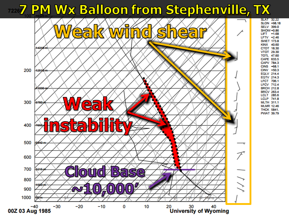 00 UTC (7:00 P.M. CDT) data from Stephenville, TX |
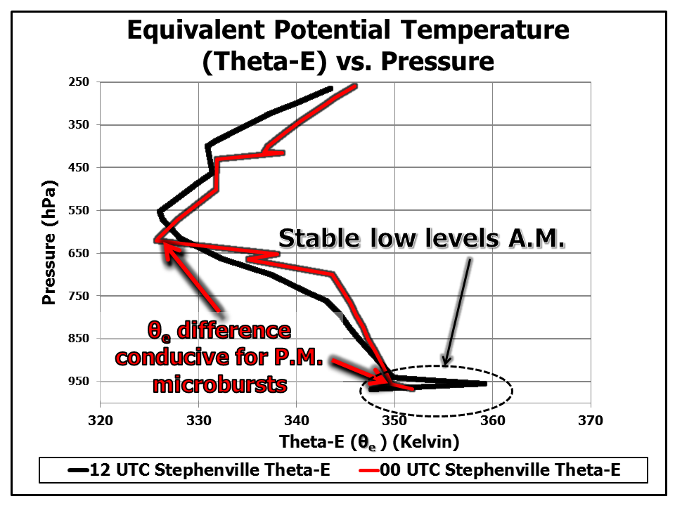
Theta-E vs. Pressure profile for 12 UTC and 00 UTC data from Stephenville, TX.
| Click one of the above thumbnails for a larger image |
Improved Detection |
The Terminal Doppler Weather Radar (TDWR) |
| The Terminal Doppler Weather Radar or TDWR, is a type of radar system that has been deployed at 45 locations across the United States and Puerto Rico. This system was developed at Lincoln Laboratories, a division of the Massachusetts Institute of Technology, back in the late 1990s. These radars were strategically placed at airports (see map) that were particularly susceptible to microbursts and other low-level atmospheric phenomenon that may be hazardous to aircraft. The TDWR are maintained by the FAA, but are used heavily by NWS and DoD personnel as well. The TDWR operate in 1 of 2 modes - monitor or hazardous mode. While in monitor mode, the TDWR typically takes around 5 to 6 minutes to complete a sampling cycle. The monitor mode is somewhat analogous to the WSR-88D's "clear air mode", in which the radar is placed in a state in which rapid low level updates are not necessary. When the TDWR detects precipitation echoes of a certain strength or detects wind shear associated with a developing microburst, the hazardous mode is activated. While in this mode, the TDWR can provide one minute updates to FAA staff, NWS/DoD meteorologists and pilots. According to the Lincoln Laboratory, no commercial airline accidents caused by wind shear have occurred at airports in which a TDWR is present and operating in the U.S. In addition to providing improved detection of weather hazardous to aircraft and airports, the TDWR offers an additional tool for NWS meteorologist to utilize to issue severe thunderstorm and tornado warnings! The figures and movies below compare and contrast the evolution of a microburst that occurred over Dallas, TX, as viewed from both the TDWR at Dallas Love Field (TDAL) and the WSR-88D at the Fort Worth Spinks Airport (FWS) on the afternoon of June 9, 2015. The right thumbnail (radial velocity) is particularly useful for meteorologists as it displays a "classic" downburst signature. |
| Click here for a GIF animation of radar reflectivity from TDAL on 06/09/2015 | Click here for a GIF animation of radial velocity from TDAL on06/09/2015 |
| In the velocity figure (from TDAL at 2100 UTC or 4:00 P.M. CDT), annotated TDAL radial velocity, note that the winds within the orange circle are spreading apart or diverging outward (as shown by the arrows) with some winds flowing towards the top left portion of the figure (towards the northwest) and some winds flowing towards the bottom right portion of the figure (towards the southeast). This signature is one that often tells meteorologist that a downburst is in progress. With the one minute data, one can clearly observe the complete evolution of the microburst from the TDWR. The thumbnails below show an animation of the part of the lifecycle of this microburst near Dallas Love Field Airport as seen from TDAL. Contrast that with radar imagery from the annotated KFWS radial velocity, the divergent wind pattern is not clearly as defined due to both the longer distance between the KFWS radar and the thunderstorm, but also the larger gaps in time between volume scans. The Dallas microburst on 06/09/2015 produced a 58 knot (67 M.P.H.) wind gust just after 4:15 P.M. CDT. For a map of some of the associated damage, click here Dallas Microburst Storm Reports. This storm report map was created with assistance from the Iowa Environmental Mesonet. |
GIF Animations (animations may take a few moments to load) of Dallas Microburst on 06/09/2015 as viewed from KFWS between 2100-2130 UTC
(5 Minute Radar Data)
| Click here for a GIF animation of radar reflectivity from KFWS on 06/09/2015 | Click here for a GIF animation of radial velocity from KFWS on 06/09/2015 |
| In addition to improvements in ground based remote sensing of these hazards, the FAA mandated that all commercial airliners have the capability to detect low level wind shear. Airline companies had approximately 5 years to comply with this new regulation. |
The Integrated Terminal Weather System (ITWS) |
|
The Integrated Terminal Weather System or ITWS is a tool that integrates a variety of meteorological instrumentation in order to support airport and aircraft operations. The ITWS combines information from surface weather observation stations, the TDWR, the Next Generation Radar (NEXRAD), aircraft observations, lightning networks, low level wind shear alert systems and Air Surveillance Radars (ASRs). Many of the algorithms that the ITWS uses were developed by engineers and scientists at Lincoln Laboratories. Full implementation of the ITWS occurred in 2001 and today services many airports across the U.S. (including DFW International and Dallas Love Field Airports). By utilizing information from each of these systems, the ITWS is able to extrapolate conditions between 30 and 60 minutes into the future, offering critical information to decision makers at airports. The ITWS has an algorithm that is dedicated to the detection of low level wind shear associated with microbursts. No tool as powerful as the ITWS Microburst Detection algorithm existed prior to the late 1990s. In addition to low level wind shear associated with microbursts, the ITWS has the capability to diagnose and extrapolate the position of gust fronts or wind shift lines that can be used to plan various runway configurations. ITWS also provides information on lightning within a certain range of the airport as well as information critical for determining the intensity and direction of non-thunderstorm low level winds. Much of this information is viewed by FAA personnel at Air Route Traffic Control Centers (ARTCCs); however, this information is often packaged and can be sent to pilots directly for their own situational awareness and decision making. In addition, the ITWS is displayed at many Center Weather Service Units (CWSUs),which are co-located with ARTCCs, and meteorologists there can often provide additional service via their expert analysis of the meteorological data.
|
Memorial |
|
The following inscription can be found on a memorial site located at Founder's Plaza located on the northwest side of DFW International Airport. It reads:
On August 2, 1985, Delta Air Lines Flight 191, a Lockheed L-1011, crashed on final approach to the Dallas-Fort Worth International Airport, approximately 2 miles due east of this site. A total of 135 persons died in the accident, including 126 of the 152 passengers on board, 8 of 11 crew members and one motorist on the ground. |