National Weather Service United States Department of Commerce

Hurricane Milton Strengthening in the Gulf of Mexico; Dangerous Heat in the Southwest

Hurricane Milton is strengthening in the southwest Gulf of Mexico. Milton is expected to become a major hurricane and bring significant impacts to Florida this upcoming week, including heavy rain and flooding, life-threatening storm surge, and damaging winds. Meanwhile, a late season heat wave will continue across portions of California into the Desert Southwest through Monday. Read More >

Banner for the 2024 eclipse


On Monday April 8th, 2024 a Total Solar Eclipse crossed North America, passing over Mexico, the United States and Canada. All of North and Central Texas was able to experience at least a partial eclipse. Learn more about this historic event, including the climatology for North and Central Texas. 


What is a total solar eclipse?

According to NASA, a total solar eclipse happens when the Moon passes between the Sun and Earth, completely blocking the face of the Sun. People located in the center of the Moon's shadow when it hits Earth will experience a total solar eclipse. Learn more about the different types of eclipses here.

Path of the Eclipse

The map below shows the path of totality (shaded area) and the centerline of the eclipse (purple line). Totality tracked directly across North and Central Texas on April 8th, 2024, started in southwestern Lampasas County at 1:34 pm CDT and ended in northeastern Lamar County at 1:48 pm CDT. The entire state of Texas saw at least a partial solar eclipse early that afternoon.

The blue dots on the map represent the locations that experienced totality, and the red dots represent the locations that experienced a partial eclipse. Click on the map for the times the eclipse occurred.


View larger map    Data Source: NASA Scientific Visualization Studio
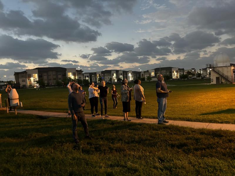
Many National Weather Service offices along the path of the eclipse were able to capture this historic event. Here are some of the pictures we took at our office in north Fort Worth and what others shared across the region. For many of us, the clouds dissipated just in time for totality. Totality lasted a little over 2 minutes at the office.


Picture of the staff at NWS Fort Worth

NWS Fort Worth staff observing the Total Solar Eclipse during totality.


Solar Eclipse Impact on Weather 


The image to the left shows the visible satellite loop as the moon shadow traveled across Texas. While there was a brief reduction in the low cloud cover as the shadow moved through, clouds began to develop again in the afternoon as storms were expected later.

How much did the temperature drop during the eclipse? Our office recorded a drop of 3.3ºF during totality.  The image to the right also shows the decrease in solar radiation. 


Eclipse Satellite Imagery Loop

Satellite Loop during the Eclipse across Texas


NWS Fort Worth Temperature drop

Temperature and Solar Radiation observation at the NWS Fort Worth


1 / 6
Eclipse from Fort Worth, TX. Photo by NWS Employee
2 / 6
Partial Eclipse from Athens, TX
3 / 6
Total Eclipse from Athens, TX
4 / 6
Partial Eclipse from Fort Worth, TX. Photo by NWS Employee
5 / 6
Total Eclipse from Fort Worth, TX. Photo by NWS Employee
6 / 6
Dallas Skyline During Totality


Timelapse of the Eclipse

Here's a look at the eclipse from our office earlier today as the shadow passes over. Totality was a little over 2 minutes at the office. #txwx #Eclipse2024 pic.twitter.com/Y2OmbbpRpj


Shadow Bands during the Eclipse

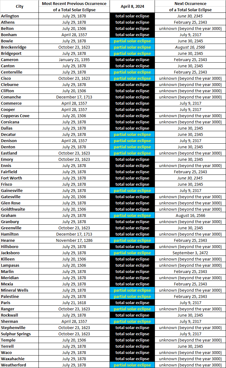
A total solar eclipse occurs about once every 18 months.  However, at any given location, it may be several centuries between occurrences.  Before the April 8th, 2024 eclipse, the most recent total solar eclipse within North or Central Texas was in 1878, and there won't be another in our region until 2317.  Hearne (Robertson County), which missed out on totality in 2024, will not experience a total solar eclipse between 1286 and 2343, a period of more than a thousand years.  To say this was a once-in-a-lifetime experience would be understating its rarity.

The map below shows the date of the previous total solar eclipse in your location (prior to 2024) and the next future occurrence (if available).  Beneath the map is a table with this information.  (Occurrences of partial and annular eclipses are not considered here.)
 

Map of Eclipse Dates


View Larger Map


Table of Eclipse Dates


Table of Eclipse Dates

italics indicate total solar eclipse only occurs within part of the city


Cloud Climatology

During the first half of April, the early afternoon frequently has clouds.  Clear or mostly clear skies occur less than 30% of the time, but mostly cloudy or overcast skies resulting in poor viewing conditions only occur around 35% of the time.  Even if clouds are present, many aspects of an eclipse may still be visible.  In other words, in a majority of the scenarios shown in the pie chart below, the sky condition may still allow for adequate eclipse viewing.


DFW Cloud Climatology Categories (April 1-15)


On average, better sky conditions occur in the Hill Country with greater cloud cover in Northeast Texas.  Although cloud cover tends to be greater during the cold season when El Niño conditions are present, the difference during April is negligible across North and Central Texas.


April 8 Cloud Cover Climatology - All Years

Cloud Climatology - April 8th - All Years

April 8 Cloud Cover Climatology - El Nino Years

Cloud Climatology - April 8th - El Niño Years

Maps created by Brian Brettschneider, NOAA


Last 29 Years of Satellite Data on April 8


Temperature and Precipitation

On April 8, normal high temperatures are in the 70s with normal low temperatures in the 50s.  Record highs are generally in the 90s while record lows are in the lower 30s.

The pie charts show the distribution of high temperatures during the first half of April.  High temperatures in the 80s are more common in Central Texas and less common in Northeast Texas.  Highs in the 70s dominate North Texas.  Cooler days (highs in the 60s or lower) are more common in Northeast Texas where they occur nearly 30% of the time.  Highs below 70º occur less than 20% of the time in Dallas/Fort Worth, Waco, and Killeen.

Rain chances are somewhat greater in Northeast Texas, but precipitation occurs about a third of the time regionwide.  Thunderstorms occur more than 20% of the time in Northeast Texas, but the chance of thunder is as low as 14% in Killeen.  Severe weather peaks during the spring in our region, and those occurrences of thunder may include large hail, damaging winds, and flooding.  The incidence of tornadoes also peaks during the spring in North and Central Texas.  As a result, residents and visitors alike are urged to keep abreast of the weather.


Dallas/Fort Worth

Climatological Data for April 8
normal high 75º
normal low 53º
record high 97º in 2020
record low 32º in 1938
chance of rain 33%
chance of thunder 18%


DFW - High Temperature Distribution (April 1-15)

Dallas/Fort Worth - High Temperature Distribution (April 1-15)


Killeen

Climatological Data for April 8
normal high 76º
normal low 52º
record high 94º in 1986 and 1963
record low 30º in 2007
chance of rain 33%
chance of thunder 14%


Killeen - High Temperature Distribution (April 1-15)

Killeen - High Temperature Distribution (April 1-15)


Paris

Climatological Data for April 8
normal high 73º
normal low 51º
record high 89º in 2020 and 1948
record low 30º in 2018 and 2007
chance of rain 36%
chance of thunder 21%


Paris - High Temperature Distribution (April 1-15)

Paris - High Temperature Distribution (April 1-15)


Waco

Climatological Data for April 8
normal high 76º
normal low 53º
record high 95º in 1948
record low 33º in 1938
chance of rain 32%
chance of thunder 17%


Waco - High Temperature Distribution (April 1-15)

Waco - High Temperature Distribution (April 1-15)


Aviation Climatology


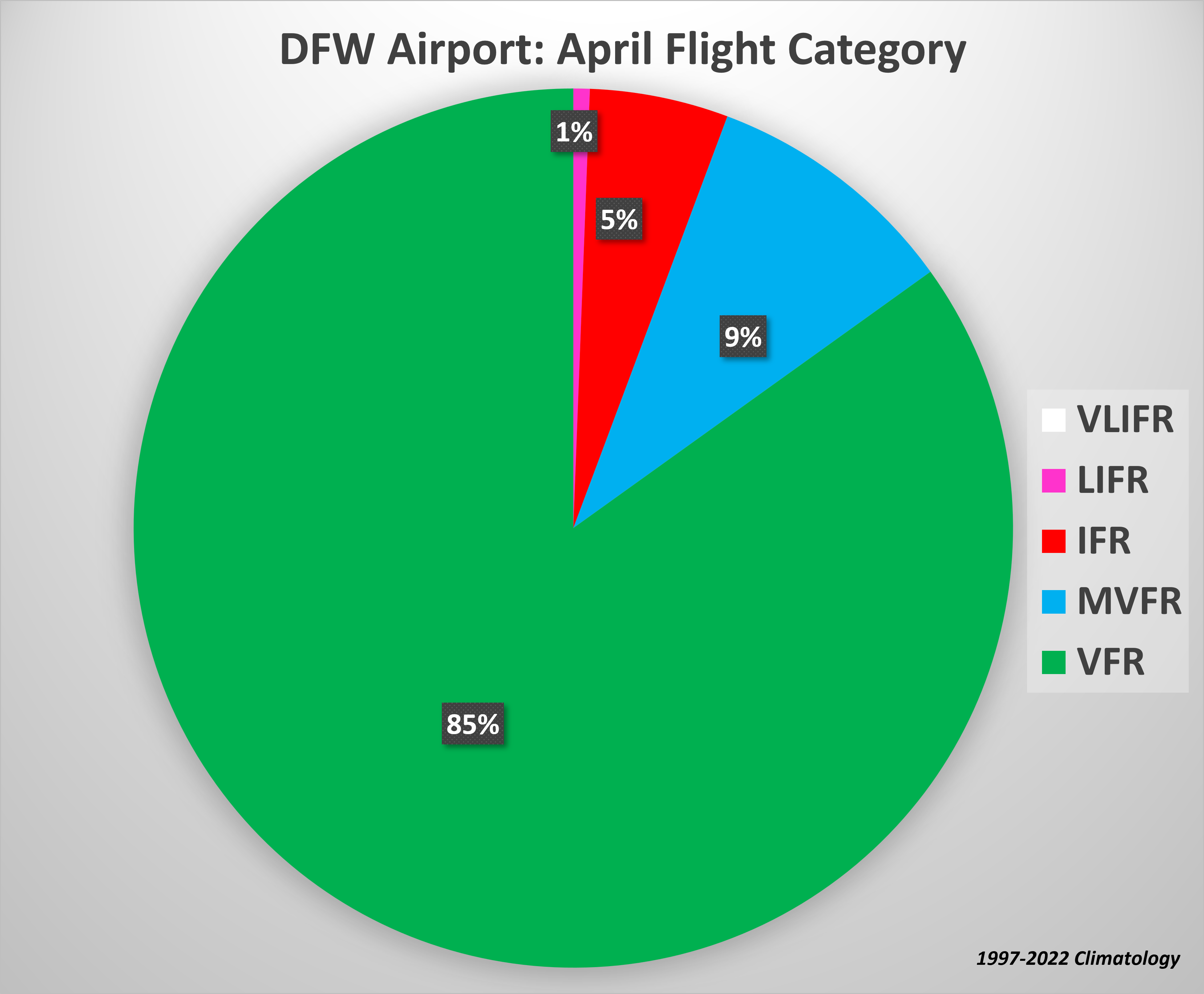
DFW Airport - Flight Categories During April


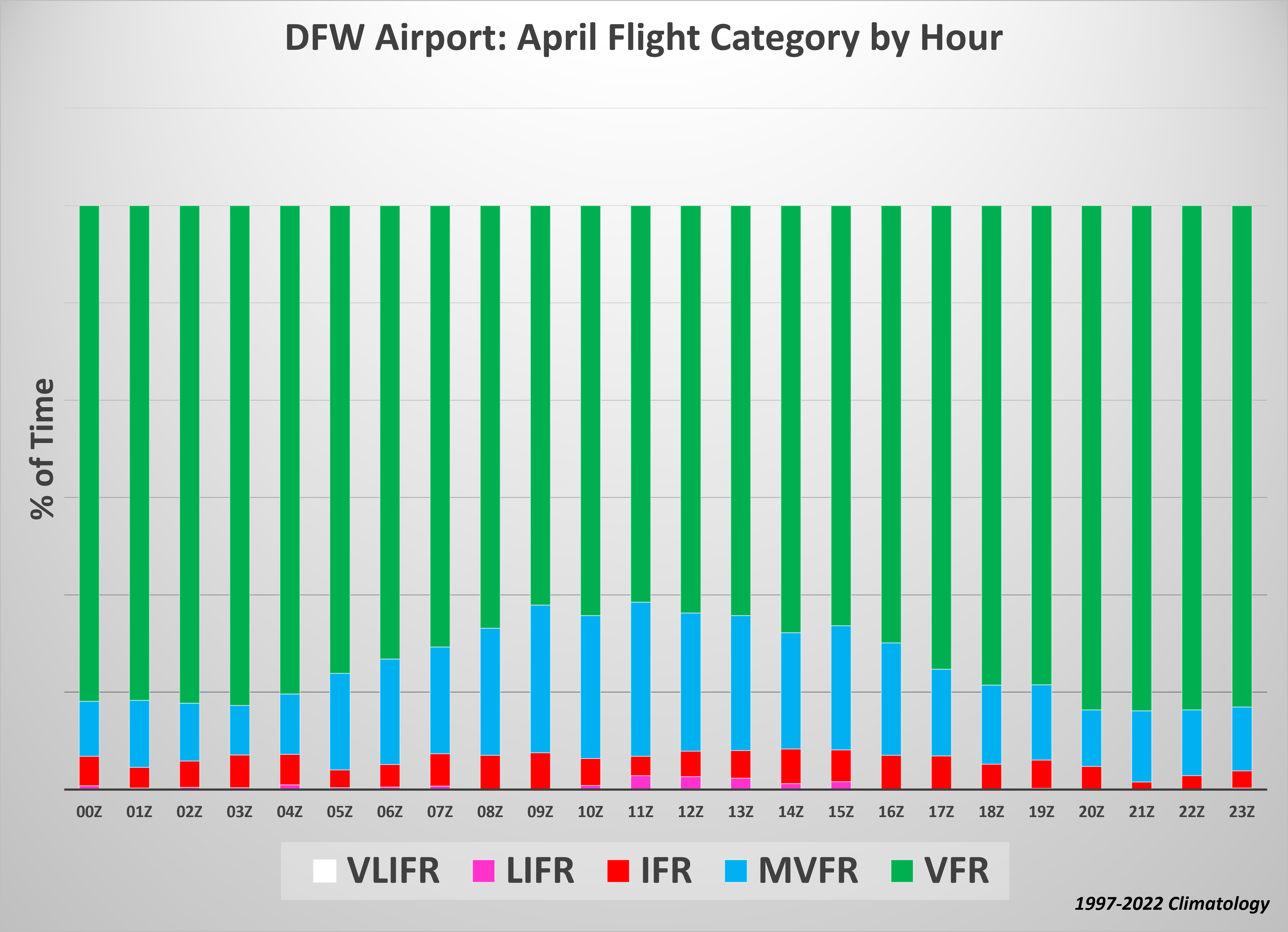
DFW Airport - April Flight Categories by Hour


Additional Eclipse Resources


Traffic & Travel Information


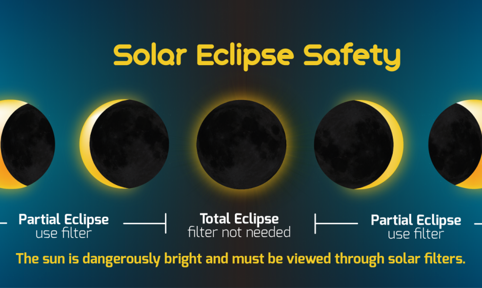
Safety

Click here to learn more about staying safe during the eclipse. Vea de forma segura el eclipse: Información en español


Image showing Solar Eclipse Safety

Credit: NOAA, Space Weather Prediction Center


Graphics


What is Solar Eclipse

What is a Total Solar Eclipse?

Solar Eclipse Safety: Travel Tips

Eclipse Safety: Travel Tips
Ver en Español

Solar Eclipse Safety: Glasses
Safety: Glasses
Ver en Español
 
What Happens during a Total Eclipse

What Happens During a Total Eclipse? Ver en Español

Solar Eclipse Impact on Weather

Solar Eclipse Impact on Weather

How would clouds impact the eclipse?
How Would Clouds Impact the Eclipse? Ver en Español
 
Eclipse Sky Cover Climatology

Eclipse Sky Cover Climatology in North Texas

Solar Eclipse: Become a Citizen Scientist

Solar Eclipse: Become a Citizen Scientist

Severe Weather Safety
Severe Weather Safety for the Total Eclipse