
Tropical Depression Two is expected to gradually strengthen and could bring tropical storm conditions to the Florida Panhandle beginning late Monday. Areas of flash flooding will be possible through Thursday along the eastern and central Gulf Coast. Severe thunderstorms will develop and move along a cold front crossing the Upper Midwest Monday, and through the Ohio Valley/Mid-Atlantic on Tuesday. Read More >
Ellis County Tornadoes: April 16, 2002
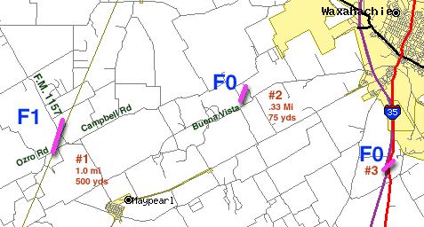
Preliminary Information
The National Weather Service conducted a survey of the damage in Ellis county from a storm that affected the area on Tuesday evening April 16th. It was determined that a total of three tornadoes occurred.
|
The second tornado touched down at approximately 750 pm about 6 miles northeast of Maypearl on Hoyt Road just north of Buena Vista road. A large awning from a mobile home was ripped off and thrown several hundred feet into a metal fence. That portion of the fence was damaged by the impact but other portions of the fence were downed by high winds as well. There was also considerable tree damage in a localized area. This tornado was rated F0 with wind speeds estimated at 70 mph. It had a path length of 1/3 mile and a path width of 75 yards. The final tornado was reported by spotters and Texas Department of Public Safety officials at 801 pm at mile marker 394 on interstate 35 south of Waxahachie. Two tractor trailers were overturned. This tornado has been rated F0. The National Weather Service staff in Fort Worth will continue to evaluate the data and reports from this storm. Any additional findings will be included in later public information statements. |


 The first tornado touched down at 731 pm about 3.5 miles northwest of Maypearl on Orzo Road where a large storage shed was destroyed. The tornado moved northeast crossing Farm Road 157. In this area several homes had mostly minor roof damage with one home losing nearly all of its shingles. Several trees were either damaged or uprooted and a few storage buildings were destroyed.
  To the east on Campbell Road the tin roof of a horse stable was blown off and a wooden beam was driven into the ground. The tornado had a broad circulation with a width of about 500 yards. Path length was approximately 1 mile and this tornado was rated F1 on the Fujita scale. Winds were estimated at 80 mph.