|
February 2011 Review
February 2011 will be remembered for the extraordinarily cold weather that began the month. For Dallas/Fort Worth, there were several events that had not occurred in many years:
-
record low temperature of 15°F on February 10 - first record low temperature since December 4, 2006
-
100 hours below freezing - longest streak since January 1997 (107 hours)
-
high temperature of 20°F on February 2 - lowest high temperature since December 22, 1990 (16°F)
-
5 consecutive mornings in the teens - first time since December 1989
After the first 10 frigid days of the month, temperatures made a dramatic rebound. The average temperatures for the latter half of the month were more than 30 degrees warmer than the opening 10 days.
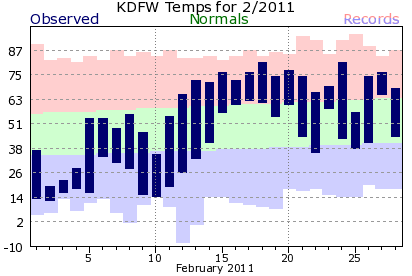 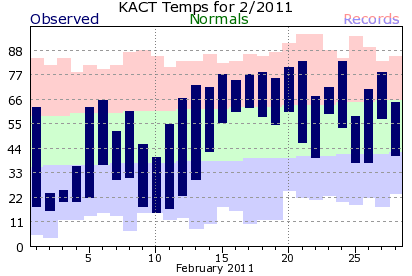
Despite some of the coldest weather in many years, mild days outnumbered the cold ones nearly 2 to 1. As a result, February 2011 was near normal. Monthly mean temperatures at DFW and Waco were actually slightly above normal.
Although January and early February were below normal, the warm weather in December and late February buoyed mean winter temperatures above normal. True to form, La Niña helped yield above normal winter temperatures, but the winter of 2010-2011 actually falls well within the middle (near normal) tercile.
|
Dallas/Fort Worth
Winter Temperatures
|
| |
2010-11 |
Normal |
Departure |
| Mean |
47.1 |
46.7 |
+0.4 |
| High |
58.1 |
56.9 |
+1.2 |
| Low |
36.1 |
36.5 |
-0.4 |
|
|
Waco
Winter Temperatures
|
| |
2010-11 |
Normal |
Departure |
| Mean |
49.1 |
48.4 |
+0.7 |
| High |
61.3 |
59.5 |
+1.8 |
| Low |
36.8 |
37.3 |
-0.5 |
|
In general, fewer snowfall events occur during La Niña winters. Early February looked nothing like La Niña as bitter arctic air invaded North Texas. At DFW Airport, there were four calendar days with measurable snowfall during the first 9 days of the month. February 1978 was the last time there were 4 days with measurable snowfall in a 9-day period.
|
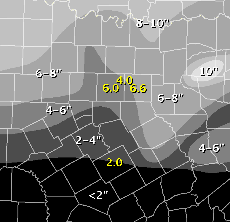
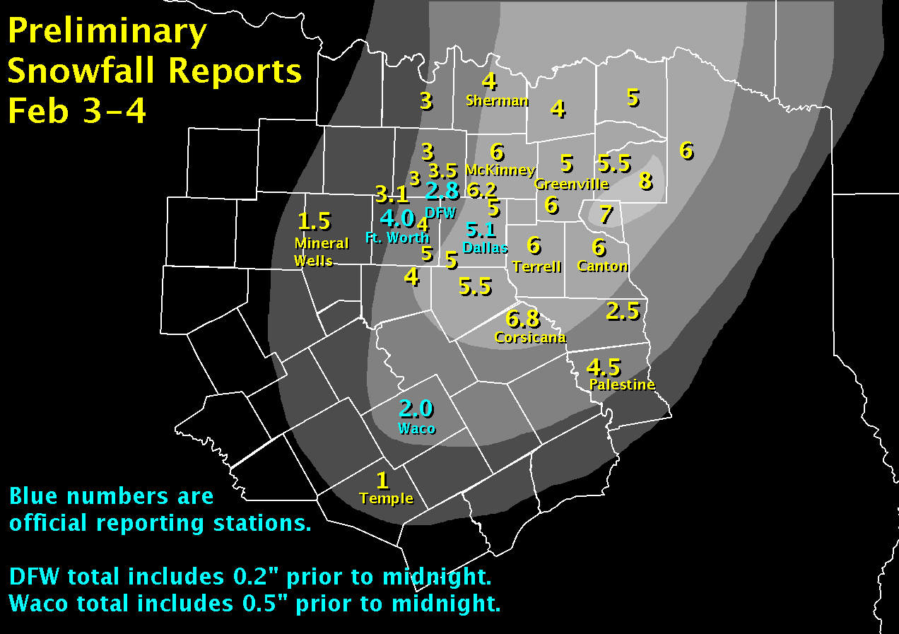
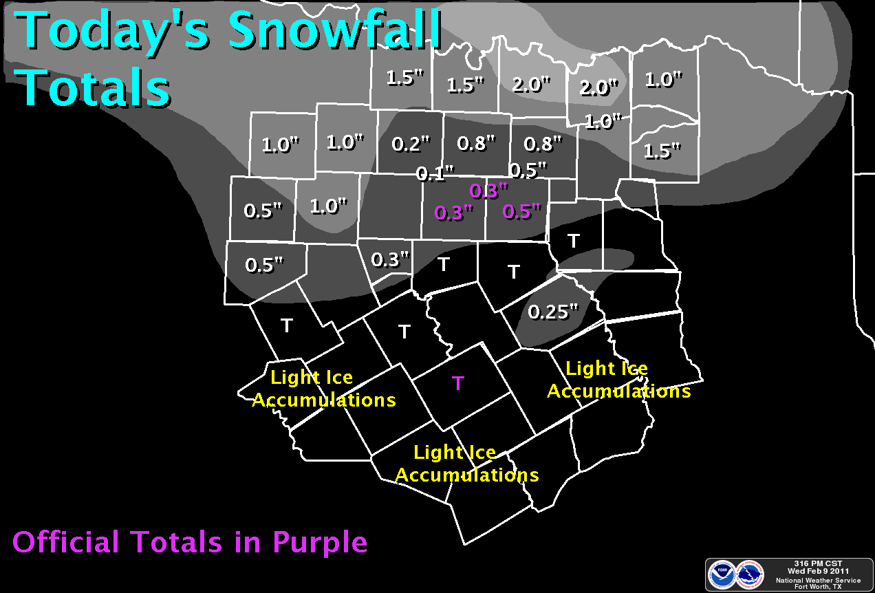
The map to the right shows the estimated February snowfall totals from across North Texas. Official totals are in yellow:
|
February 2011 - Official Snowfall Totals
|
| Location |
Snowfall |
| DFW Airport |
4.0 |
| Waco |
2.0 |
| Dallas |
6.6 |
| Fort Worth |
6.0 |
Dallas/Fort Worth
Greatest Snowfall Totals
for February |
| Rank |
Snowfall |
Year |
| 1 |
13.5 |
1978 |
| 2 |
12.6 |
2010 |
| 3 |
7.5 |
1924 |
| 4 |
4.2 |
1951 |
| 5 |
4.0 |
2011 |
| 6 |
3.7 |
1975 |
| 7 |
3.6 |
1929 |
| 8 |
3.5 |
2002 |
| 9 |
3.1 |
1938 |
| 10 |
3.0 |
1903 |
|
Waco
Greatest Snowfall Totals
for February |
| Rank |
Snowfall |
Year |
| 1 |
13.0 |
1924 |
| 2 |
4.8 |
1966 |
| 3 |
4.0 |
1923 |
| 4 |
3.6 |
2010 |
5
(tie) |
3.0 |
1940 |
| 3.0 |
1910 |
| 7 |
2.3 |
2004 |
8
(tie) |
2.0 |
2011 |
| 2.0 |
1965 |
| 10 |
1.9 |
1985 |
|
|
Estimated Snowfall - February 2011
|
|
|
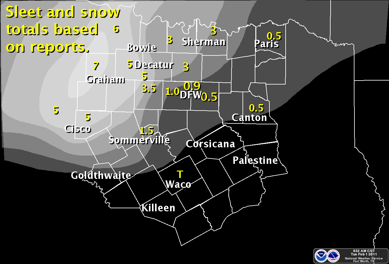
February 1
|
February 3-4
|
February 9
|
|
During the February 3-4 event, Waco recorded 2 inches of snow. For Waco, this is one of only five events with at least 2 inches of snowfall during the last 25 years. One of the previous events occurred just last winter. The other events are likely memorable as well.
|
|
Waco
Snowfall Events of 2" or More
During the Last 25 Years
|
| Snowfall |
Dates |
| 2.0 |
February 3-4, 2011 |
| 3.1 |
February 23, 2010 |
| 3.5 |
April 7-8, 2007 (Easter) |
| 2.3 |
February 13-14, 2004 (Valentine's Day) |
| 2.4 |
November 25, 1993 (Thanksgiving) |
|
|
|
Following the snow events, little precipitation fell the remainder of the month. Two events during the last week of the month brought rainfall to areas mainly east of the I-35 corridor. Even with that rain, nearly all of North Texas finished February with below normal precipitation. The driest areas were in western portions of North Texas.
Keeping with La Niña, winter precipitation totals were below normal across all of North Texas. Thanks to the heavy rain/snow event on January 9, Waco was within the middle (near normal) tercile. However, DFW was very near the dividing line between the middle and driest terciles.
|
|
|
|
| February 2011 Precipitation |
| Location |
Precipitation |
Normal |
Departure |
| DFW Airport |
0.92 |
2.37 |
-1.45 |
| Waco |
1.82 |
2.43 |
-0.61 |
| Dallas Love Field |
1.35 |
2.31 |
-0.96 |
| Fort Worth Meacham |
0.78 |
|
|
| Dallas Executive |
0.94 |
|
|
| Fort Worth Alliance |
0.79 |
|
|
| Arlington |
1.24 |
2.60 |
-1.36 |
| Denton |
0.71 |
2.55 |
-1.84 |
| McKinney |
1.33 |
2.91 |
-1.58 |
| Terrell |
2.68 |
2.95 |
-0.27 |
| Corsicana |
2.05 |
3.08 |
-1.03 |
| Mineral Wells |
0.72 |
1.99 |
-1.27 |
|
| Winter 2010-2011 Precipitation (December-February) |
| Location |
Precipitation |
Normal |
Departure |
% of Normal |
| DFW Airport |
4.57 |
6.84 |
-2.27 |
67 |
| Waco |
6.29 |
7.09 |
-0.80 |
89 |
| Dallas Love Field |
4.66 |
6.73 |
-2.07 |
69 |
| Fort Worth Meacham |
3.63 |
|
|
|
| Dallas Executive |
3.91 |
|
|
|
| Fort Worth Alliance |
3.64 |
|
|
|
| Arlington |
4.92 |
7.43 |
-2.51 |
66 |
| Denton |
3.93 |
7.15 |
-3.22 |
55 |
| McKinney |
4.99 |
8.58 |
-3.59 |
58 |
| Terrell |
6.70 |
8.73 |
-2.03 |
77 |
| Corsicana |
6.72 |
9.17 |
-2.45 |
73 |
| Mineral Wells |
2.92 |
5.15 |
-2.23 |
57 |
|
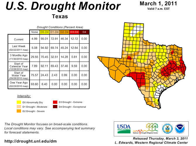
Precipitation deficits grew regionwide this winter, and drought has continually expanded across the Lone Star State.
|
|
|