
Dangerous heat will expand from the Gulf Coast into the Southern Plains and Desert Southwest through week's end. Additional extreme heat impacting the Pacific Northwest will shift to the northern Plains by the weekend. Tropical Storm Bertha is expected to continue to impact portions of the northwestern Gulf Coast from south central Louisiana to the upper Texas coast today. Read More >
Fort Worth/Dallas, TX
Weather Forecast Office
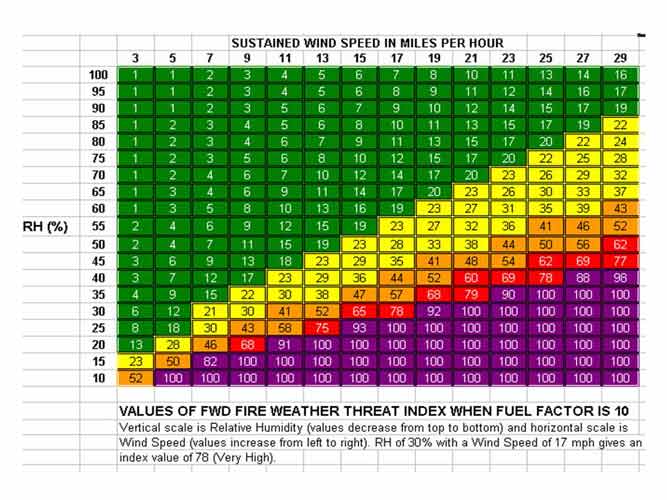
What is the WFO FWD Fire Weather Threat Index?
The National Weather Service (identifier FWD) in Fort Worth has developed an index to assess the fire weather threat across north Texas. The FWD Fire Weather Threat Index that you see on the WFO Fort Worth fire weather pages is a locally-developed scaled value derived from relative humidity, wind speed, and fuel factor.
The values of the index range from 1 (minimal threat) to 100 (highest threat). Theoretically, values should be near 1 when winds are light, relative humidities are over 90%, and fine fuels (typically grasses) are either green or moist from recent rains.
On the other extreme, values should be near 100 (highest threat) during dry periods in the fall and winter when sustained winds are at least 20 mph and relative humidity values are less than 35%. Recent rainfall and/or substantial green vegetation could make the FWD Fire Threat Index much lower, even with low humidities and strong winds.
Fire Weather Threat Values of FWD Fire Weather Threat Index
|
LOW |
MODERATE |
HIGH |
VERY HIGH |
EXTREME |
Current Hazards
National Outlooks
Tropical
Local Storm Reports
Storm Reports (Graphical)
Submit Storm Report
Tornado Warnings
Severe Thunderstorm Warnings
Flash Flood Warnings
Forecasts
Forecast Discussion
Graphical Forecast
Aviation Forecasts
Fire Weather
Hazard Planner
N. Texas Convective Parameters
US Dept of Commerce
National Oceanic and Atmospheric Administration
National Weather Service
Fort Worth/Dallas, TX
3401 Northern Cross Blvd.
Fort Worth, TX 76137
817.429.2631
Comments? Questions? Please Contact Us.

