A significant heat wave is underway for the Intermountain West, Northern Plains, and Upper Great Lakes, peaking in intensity through midweek and lingering across parts of the Northern Plains and Midwest until this weekend. In southwest Texas, excessive rainfall may bring a risk for potentially life-threatening flash and arroyo flooding through Thursday. Read More >
|
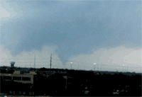
Tarrant County Tornadoes: April 16, 2002
|
|||
|
On April 17, a team of meteorologists from the National Weather Service in Fort Worth conducted a survey of the damage caused by the tornadoes in Tarrant County. A total of four separate tornado tracks were found as the storm tracked from near Everman to east Fort Worth.
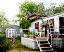
trees was noted as the tornado moved northeast. The tornado then moved through the Bonaventure mobile home park. One mobile home in the park lost most of its roof. |
|
||
|
Numerous others suffered minor roof damage and lost skirting around their bases. Trees were also damaged. The tornado dissipated at approximately 548 pm along Lon Stephenson Road and east of Forest Hill drive. This tornado was rated F0 on the Fujita scale, with winds estimated near 70 mph. Path length was 1.6 miles and average path width was 100 Yards. |
|||
|
|
The second tornado developed at approximately 551 pm, near the intersection of Anglin drive and southeast Loop 820. Trees were uprooted just north of Loop 820 and Anglin, and shingles were peeled from roofs near Alandale and Suellen Road. |
||
|
The third tornado developed at approximately 554 pm, along Redwood Blvd and north of Collett Little Road. The tornado downed trees and damaged mobile homes along Redwood North and Redwood East streets. The tornado continued northeast, breaking large tree limbs along Mosson and Saunders roads. The tornado crossed east Loop 820 near Sun Valley Drive and dissipated north of Laster Road, just east of Loop 820. This tornado was rated F0 on the Fujita scale, with estimated winds of 70 mph. Path length was 0.8 miles and average path width was 70 yards. |
|||
|
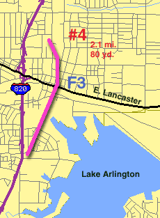
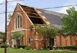
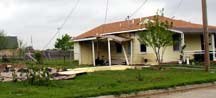
As the third tornado was in progress, the storm developed a new area of rotation west of Lake Arlington. This area spawned the most significant tornado of the four. This tornado developed at 559 pm just south of Ramey Avenue and just east of Loop 820 in east Fort Worth. The tornado damaged a strip mall and heavily damaged a duplex on the south side of Ramey. A large sign from the mall was carried nearly 100 feet. The duplex had its roof removed and portions of the walls were blown down. Several homes along Carruthers, Felder, Debra, and Vel roads had their roofs partially removed.
|
|
||
|
Just west of the Handley-Rosedale intersection, a metal-supported billboard sign was bent to the ground. Two businesses, one of brick construction and one of metal, were heavily damaged along Handley drive between Rosedale and Lancaster Avenue. The brick building had part of its roof removed, part of its roof collapsed, and exterior walls were blown down. The metal building was completely removed from its foundation and deposited 50 feet to the northwest. The tornado turned to the north after it crossed Lancaster Ave. Roof and tree damage was observed between Handley and Forest, to the north of Lancaster.
|
|||


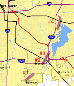
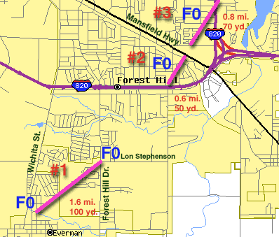
 The tornado dissipated at approximately 553 pm between Melinda Road and Mansfield Highway. This tornado was rated F0 on the Fujita Scale, with estimated winds of 60 mph. Path length was 0.6 miles and path width was 50 yards.