
Remnant moisture from Tropical Storm Rachel will persist over portions of the Great Basin and Southwest on Monday, bringing a potential heavy to excessive rainfall risk. Well above average and potentially record breaking temperatures will develop across the Plains and Midwest early this week, spreading into the Lower Mississippi Valley and Southeast midweek. Read More >
The Heat IndexWe use this table to provide you with Heat Index values. These values are for shady locations only. Exposure to full sunshine can increase heat index values by up to 15°F. Also, strong winds, particularly with very hot, dry air, can be extremely hazardous as the wind adds heat to the body. The Heat Index Chart is below. 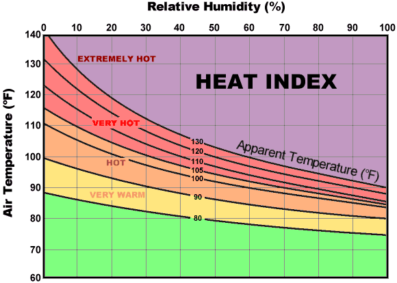 How to read the chart...Follow the temperature line until it intersects the relative humidity line. Then read the Heat Index on the curved line. For example, an air temperature of 100°F and Relative Humidity of 40%. Follow the 100°F temperature line until it intersects the 40% relative humidity line. Then curved line that also intersects is the Heat Index of 110°F, or Very Hot. That is the temperature the body thinks it is and attempts to compensate for that level of heat. Remember, these values are in the SHADE. You can add up to 15°F to these values if you are in direct sunlight. The chart below tells you the risk to the body from continued exposure to the excessive heat.
|
||||||||||||||||||||
 NEXT: Beat the Heat - Safety Rules NEXT: Beat the Heat - Safety Rules |
||||||||||||||||||||
  |



 Follow us on X
 Follow us on Facebook
 Follow us on YouTube
 FWD RSS Feed