National Weather Service United States Department of Commerce
Ice Accumulation January 23- 25, 2026

Ice Accumulation Jan 23-26, 2026


Sleet Accumulation January 23-35, 2026

Sleet/Snow Accumulation Jan 23-26, 2026


Visible satellite imagery from Texas

Visible Satellite Imagery of Texas on Wednesday Jan 28th


  • A powerful winter storm impacted much of the eastern CONUS during the weekend of January 23-26th. Widespread mixed precipitation occurred across much of North and Central Texas from Friday night through much of the day Sunday.
  • Sleet, snow, and/or freezing rain resulted in widespread hazardous travel conditions, thousands of canceled flights, and school/business closures. The frigid temperatures persisted even after the precipitation ended over much of the following week.
  • The official snowfall total for Dallas/Fort Worth International Airport was 2.4” (January 24-25).
  • The official snowfall total for Waco Regional Airport was 0.3" of sleet on January 24, and a Trace of sleet on January 25th. 
  • This significant event impacted most of Texas and the South Central and Southeastern US. The image below shows the NWS winter weather products on January 25, 2026.

NWS Radar at 8 am and Products issued January 25, 2026

NWS Warnings, Watches, and Advisories on January 25, 2026. Radar and temperature captured at 8 am January 25, 2026. 
(image by: NWS Southern Region ROC)

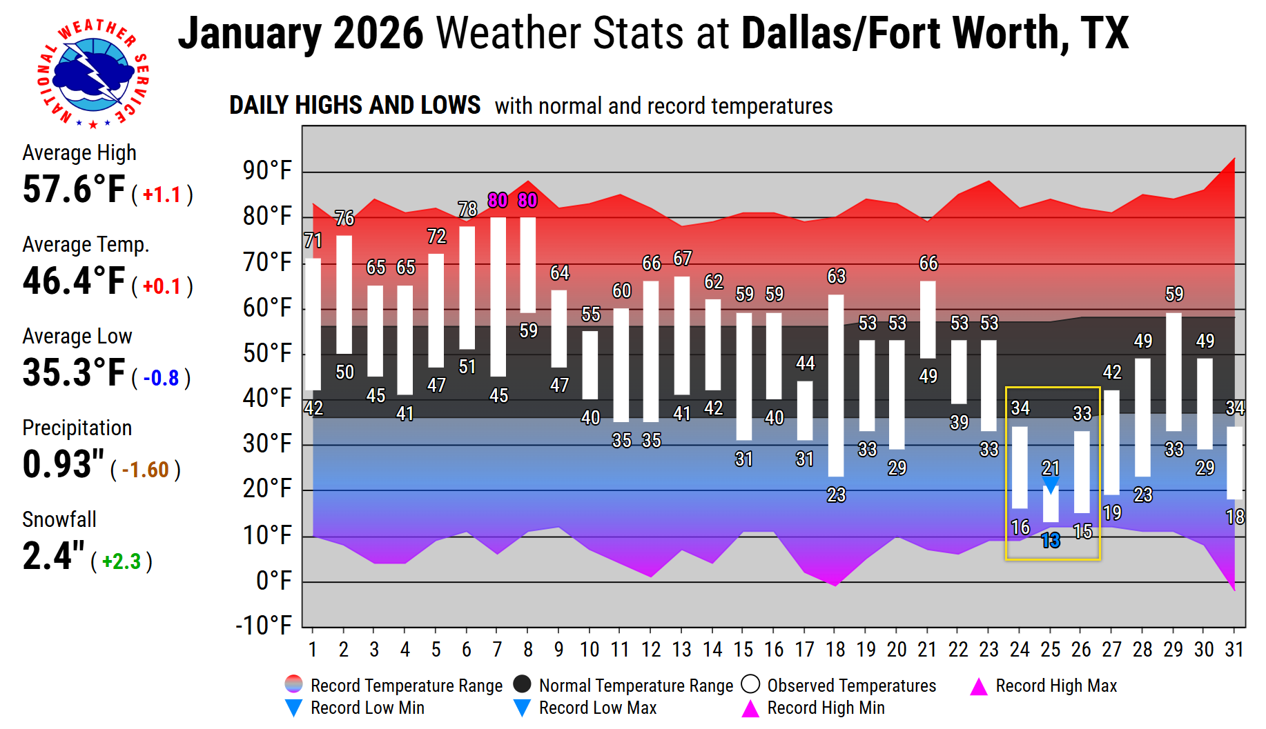
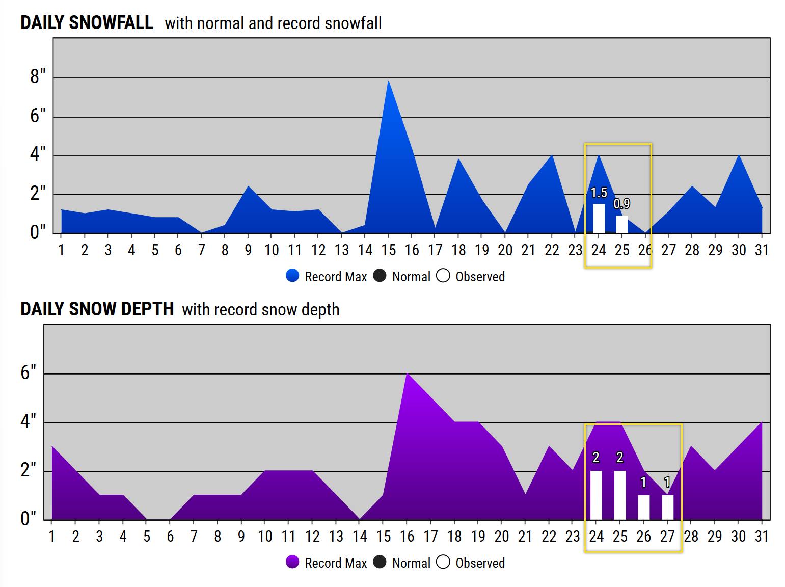
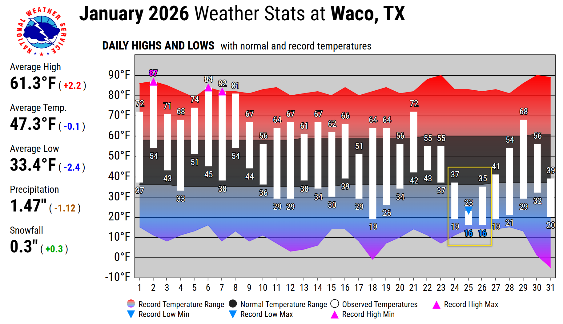
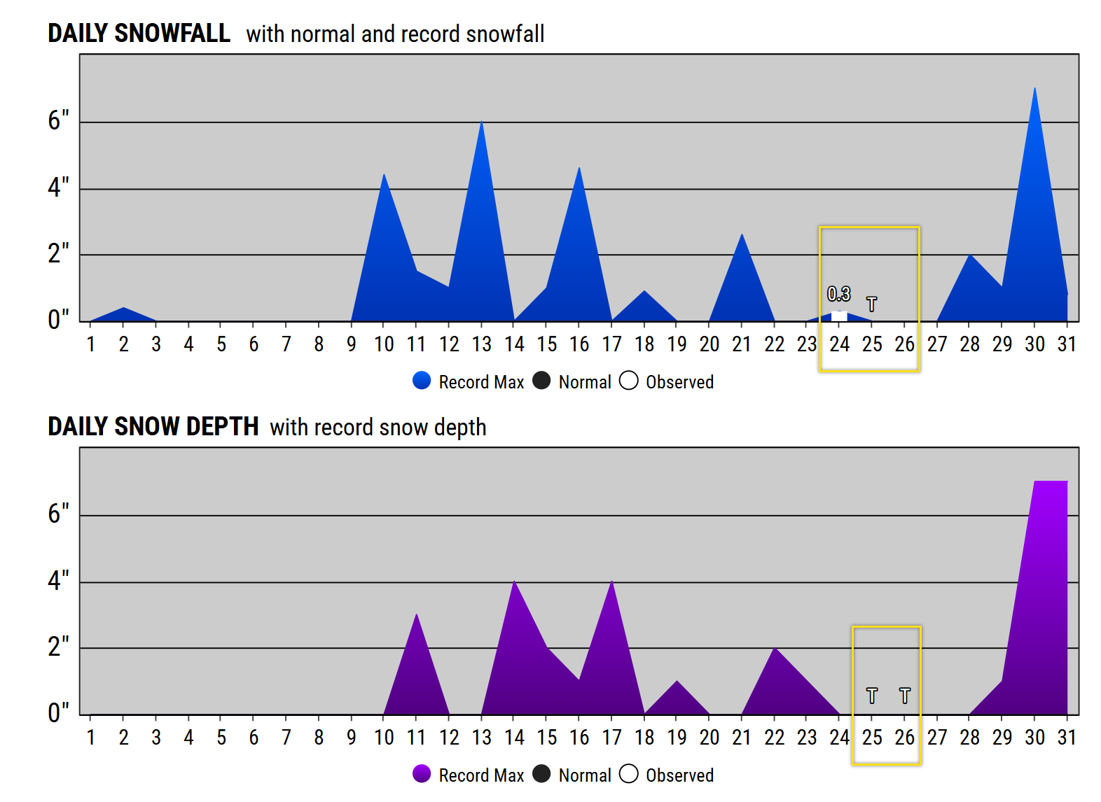
The late-January 2026 winter storm was a classic "shallow cold air" event with multiple shortwave troughs moving over top of the cool airmass. The storm was characterized by a powerful Arctic front that undercut a moist, subtropical air mass, leading to a prolonged period of freezing rain, sleet, and eventually snow.

Synoptic Overview

The storm was driven by a deep, positively tilted longwave trough that became established across the Western U.S., allowing a series of shortwave disturbances to eject into the Southern Plains.

Upper-Level Analysis (300mb & 500mb)

  • 300mb: A powerful subtropical jet was positioned across the Southern Tier, providing significant synoptic-scale lift through upper-level divergence in the left-exit region of a jet streak.

Map Analysis of 300 mb


  • 500mb: A deep closed low over the Desert Southwest moved slowly eastward. Strong vorticity advection ahead of this low provided the mid-level forcing necessary for widespread precipitation across North Texas.


Low-Level Analysis (850mb & Surface)

  • 850mb: The 850mb layer remained above freezing (the "warm nose") for much of Jan 23 and 24. This warm layer was fueled by southwesterly flow tapping into Pacific and Gulf moisture.


  • 925mb/Surface: A ~1045mb Arctic high pressure system over the Northern Plains bled a very shallow, dense cold air mass southward. The surface “freezing line” moved into North Texas Friday evening, the Metroplex Friday night, and Central Texas on Saturday, with temperatures crashing from the 50s into the 20s in just a few hours.


Thermodynamics Profile (RAOB Soundings)


The defining feature of this storm was the vertical temperature profile. Early RAOB (Radiosonde Observation) soundings from Jan 24 showed a classic "Warm Nose" signature.


  1. Surface to ~925mb: Sub-freezing temperatures. This layer was roughly 2,000–3,000 feet deep—just deep enough to refreeze raindrops into sleet (ice pellets) rather than keeping them as freezing rain.

  2. ~925mb to 800mb: An elevated melting layer with temperatures above freezing. Snowflakes falling from the clouds would melt completely in this layer.

  3. Above 800mb: Typical sub-freezing temperatures where precipitation began as snow.

By the evening of Jan 25, the 850mb "warm nose" finally eroded as the mid-levels cooled, transitioning the p-type from sleet to snow. There were also periods of lake-effect snow that developed downwind of many area lakes, particularly those with extended north-south fetches.

DFW Airport

  • Total snow/sleet accumulation for this event was 2.4 inches (January 24-25).
    • 1.5 inches was recorded on January 24th, and 0.9 inches was recorded on January 25th, for a total of 2.4 inches for this event.
    • 0.9 inches is the new record for snowfall on January 25. The previous record was 0.1 inches set back in 1949.
  • Hours at or below freezing:
    • 58 consecutive hours: from 1 am on January 24 through 4 pm on January 26
    • The temperature climbed to 33 degrees from 4 pm to 6 pm on Monday January 26, but then dropped at or below freezing for another 16 hours until 10 am Tuesday January 27. Combined with the 58 hours above, this makes a total of 74 nonconsecutive hours.
  • New record for Low Max Temperature of 21 degrees on Sunday January 25. The previous record was 23 degrees set in 1940.
  • January was very dry and warm ahead of this event.  Only 0.2 inches of rain (rank #6) was observed at DFW Airport from Jan 1-21. The first three weeks were also the 8th warmest by average temperature.
DFW Airport Climate Stats

January 2026 Daily Temperatures


DFW Snowfall January 2026

January 2026 Daily Snowfall and Snow Depth

Waco Regional Airport

  • 0.3" of sleet on January 24, and a Trace of sleet on January 25.
    • Tied record for snowfall of a Trace set on Sunday January 25. The record of Trace also occurred in 1961, 1949, and 1943.
  • Hours at or below freezing:
    • 56 consecutive hours: from 8 am on January 24 through 4 pm on January 26.
    • The temperature climbed to 33 degrees from 4 pm to 6 pm on Monday January 26, but then dropped at or below freezing for another 17 hours until 11 am Tuesday January 27. Combined with the 56 hours above, this makes a total of 73 nonconsecutive hours.
  • New record for Low Max Temperature of 23 degrees on Sunday January 25. The previous record was 24 degrees set in 1940.
Waco Regional Airport Climate Stats

January 2026 Daily Temperatures


Waco Snowfall January 2026

January 2026 Daily Snowfall and Snow Depth


Note: 

  • For the purposes of snow observing and reporting, frozen precipitation or snowfall includes snow, sleet (ice pellets), snow pellets, snow grains, and ice crystals.
  • Freezing precipitation (freezing rain or freezing drizzle) is considered liquid precipitation and is not included in snowfall.


Impacts to Aviation


This winter storm event brought significant impacts to aviation across North and Central Texas.

  • FAA operational initiatives: Ground delay programs, arrival rate limits, and recovery measures were applied to manage traffic flow and maintain safety under storm conditions.
  • Surface and deicing constraints: Runway, taxiway, and ramp icing onset and ongoing deicing operations limited the availability of safe aircraft parking, taxiing, and gate access.

For DFW Airport

  • The airport spent most of the event at a reduced rate of 24-28 (rotating three runways for arrivals/departures/cleaning), dropping to a minimum rate of 12 (one runway for both departures and arrivals) on the afternoon/evening of Sunday, January 25th.
  • Total Flight Cancellations: The event resulted in an estimated ~5,859 total flight cancellations from January 23rd through January 28th.
  • Significant flight delays: Hundreds of flights were delayed each day (e.g., 411 on Jan 25, 787 on Jan 26), reflecting persistent congestion in airport operations.

*Source FAA 


DFW Airport - airplane and deicing

DFW Airport - social media post

Dallas Love Field - ice removal operations
Dallas Love Field - social media post
DFW Airport - ice and snow removal operations
Ice and Snow Removal Operations at DFW Airport - social media post


DFW Airport - social media post

Ice Accumulation January 23-26, 2026

Ice Accumulation Jan 23-26, 2026


Snow and sleet accumulations January 23-26, 2026

Snow and Sleet Accumulation Jan 23-26, 2026


NWS Fort Worth Office on January 31, 2023
Snow and Sleet and Irving 
Satellite Image
Satellite Imagery during the morning of Monday January 26, 2026


Snow and sleet in North Richland Hills

Snow and sleet in North Richland Hills


Snow and Sleet in highways in Fort Worth
Snow and ice cover I-35 in north Fort Worth
(photo by Dallas Morning News)

Ice in downtown Dallas

Winter precipitation over downtown Dallas
(photo by Dallas Morning News) 
Snow and sleet in Fort Worth
Roads covered by sleet in downtown Fort Worth
(photo by Fort Worth Star-Telegram)


TxDOT Camera across the region
TxDOT Camera shows snow and sleet on roads
TxDOT Camera across the region
TxDOT Camera shows snow and sleet on roads


TxDOT Camera across the region
TxDOT Camera shows snow and sleet on roads
TxDOT camera across the region
TxDOT Camera shows snow and sleet on roads


* photos courtesy of NWS employees, partners, the public, etc.


nws logo

Media use of NWS Web News Stories is encouraged!
Please acknowledge the NWS as the source of any news information accessed from this site.

Additional event recaps can be found on the NWS Fort Worth Past Event Page.

nws logo