|
-
September 1874: A tropical storm made landfall on the lower Texas coast, and moved north through the central part of Texas. This storm may account for some high monthly precipitation totals, such as ten inches for some places. (1)
-
September 1886: The sixth hurricane of the season made landfall near Brownsville, and moved up through Texas, possibly causing the almost four and a half inches of rain in Palestine on the 24th of the month. (2)
-
September 1897: The second hurricane of the season makes landfall near Galveston and causes 13 deaths. The remnants brought two to three inches of rain to Forestburg, Temple, Weatherford and Hewitt. (4)
-
September 9-10, 1900: The first hurricane of the season, the infamous Galveston hurricane, brings its remnants into North Texas. Fort Worth recorded wind gusts up to 52 miles per hour. Widespread one to three inch rains occurred, with Hearne, Dublin and Temple recording four inches. (5)
-
August 17-19, 1915: A hurricane that hit Galveston dumped four to eight inches of rain over the north and east sections of North Texas. Fifty to sixty mile per hour winds, uprooted trees, signs blowing down, and windows breaking where reported at DFW. (6)
-
September 8-10, 1921: A weak hurricane moved onshore near Tampico, Mexico, and mixed with a weak cold front, over south central Texas, bringing a United States record of 36.4 inches of rain in 18 hours to Thrall. The floods killed 215 people and caused 19 million dollars in damage over central Texas. About six tornadoes occurred. (8)
-
September 14-18, 1936: A tropical disturbance moved inland over the lower Texas coast, and the remnants brought heavy rain to western and southwestern sections of North Texas. There was five to ten inches of rain and extensive flooding. The flooding of the Concho River damaged or destroyed highways, bridges and 300 buildings. (10)
-
August 26-27, 1947: The third hurricane of the season moved inland near Galveston and brought over nine inches of rain at Dallas, with six inches falling in a span of three hours. Fort Worth only saw four inches. No flooding was reported, but there was a sharp rise in the water level of the river. (13)
-
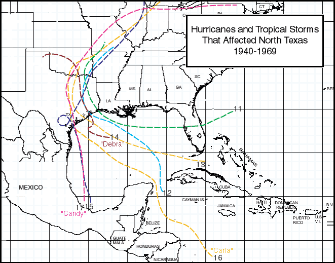
July 26, 1959: The remnants of Hurricane Debra, after coming ashore on the Upper Texas Coast, moved through Tyler and Paris, but had little impact on the DFW area. (14)
-
June 24-26, 1960: A tropical low, formerly a tropical storm that had made landfall along the Upper Texas Coast, brought heavy rainfall to east Texas. There was locally an inch or less, but the clouds and rain brought mild temperatures. (15)
-
September 11-13, 1961: The remnants of Hurricane Carla, which made landfall near Port O'Connor, moved across North Texas, bringing an east wind of about 30-40 miles per hour with gusts to 65 miles per hour. A new low barometric record was set at Carter Field of 28.94 inches. Three to five inches of rain fell, but was very beneficial. However, a total of about 408 million dollars in damage occurred in Texas with Carla, with the most damage occurring in the coastal areas. (16)
-
June 23-24, 1968: Thunderstorms brought widespread one to two inch rains to the area, possibly being the remnants of Tropical Storm Candy, which made landfall near Port Aransas. In the evening, a tornado was blamed for damaging roofs and trees in Brock. (17)
-
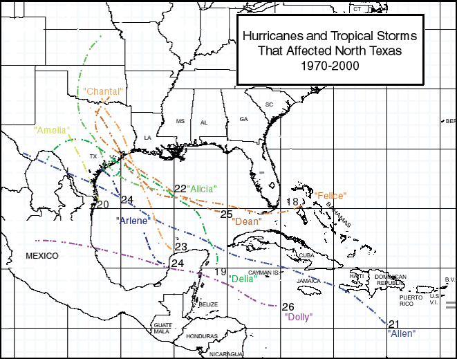
September 5-6, 1973: The remnants of Tropical Storm Delia, which made landfall on the Upper Texas Coast, caused widespread two to three inch rains. Some Denton and Collin county locations received four to six inches of rain. (19)
-
August 1-5, 1978: The remnants of Tropical Storm Amelia, which came ashore along the lower Texas coast, brought torrential rain(20-30 inches) to parts of the Hill Country and the Albany area. A total of 29 inches of rain fell at Albany in only 24 hours, which is the largest amount ever recorded in a day at an official Texas station. Tremendous flash flooding occurred and 33 deaths resulted. (20)
-
August 9-10, 1980: Hurricane Allen moved inland across southern Padre Island, bringing heavy rain and flooding to south Texas. Tornadoes occurred in Austin, and did much damage. In DFW, high cloudiness, brought maximum temperatures in the 90's, providing limited relief from a summer heat wave that saw 69 100-degree days. (21)
-
October 12-13, 1981: The remnants of Pacific Hurricane Norma came across central Texas. Torrential rain fell and a few weak tornadoes were spawned. In Tarrant County, five people drowned. Ten to thirteen inches of rain fell between Denton and Bridgeport. One to three inches fell over Johnson and Ellis counties. Also, ten to twenty inches fell from Abilene to Gainesville. High winds damaged buildings and trees near DFW. Total damage was around 50 million dollars.
-
August 18-19, 1983: The remnants of Hurricane Alicia, which came ashore along the middle to Upper Texas Coast, moved through North Texas, with widespread two to three and a half inch rains and localized flooding. One boy drowned, and a roof of a gym collapsed. Trees and power lines were downed and a highway sign blew over, killing a truck driver. DFW only recorded wind gusts up to 45 miles per hour. (22)
|
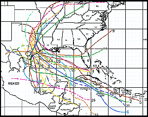
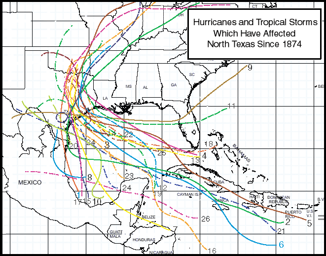
Hurricanes and Tropical Storms That Have Affected North Texas Since 1874
(Click image for larger view.)
1874-1939 Map
1940-1969 Map
1970-2000 Map
-
October 18-20, 1983: The remnants of Pacific Hurricane Tico brought torrential rains of eight to fifteen inches over west Texas, and southwest and central Oklahoma. The outskirts of the system produced less than an inch of rain over most of the local area.
-
August 1-2, 1989: After coming ashore along the Upper Texas Coast, the remnants of Hurricane Chantal moved through North Central Texas. Heavy rain and flooding occurred in Eastland, Erath and Stephens counties. Burleson recorded the most rainfall total of two and three quarters inches. (23)

-
June 20-21, 1993: The remnants of Tropical Storm Arlene, which came ashore along the lower Texas coast, brought 10-16 inches of rain, widespread flooding, and damage to east Texas. Damage amounted to around three to five million dollars and one death. (24)
-
July 31, 1995: The remnants of Tropical Storm Dean, after making landfall along the middle to Upper Texas Coast, brought heavy rain to Hood and Somervell counties. Six to ten inches of rain fell between Glen Rose and Lipan, and street flooding occurred in Arlington. An F0 tornado damaged a home and destroyed outbuildings. Street flooding also occurred in Dallas, Fort Worth and Burleson. (25)
-
August 27-31, 1996: The combination of a weak cold front and the moisture from Hurricane Dolly brought two to four inches of widespread rain over the local area. Cleburne received 5.4 inches. In Parker and Johnson counties, roads were flooded. Over the five day span, street flooding occurred in many other cities as well, including Decatur, Weatherford, Azle, Dallas, Fort Worth and Euless. (26)
-
September 23-24, 2005: Although a Category 5 storm in the Gulf of America, Hurricane Rita made landfall as a Category 3 storm just east of the Texas-Louisiana border during the early morning hours of September 23, 2005. Rainfall was scant in North Texas, but wind gusts reached 40 to 50 mph in the Dallas/Fort Worth Metroplex on September 24. Gusts were near 60 mph east of Dallas.
-
August 5-6, 2008: Tropical Storm Edouard made landfall on the Upper Texas Coast on August 5. During the early morning hours of August 6, the remnants were centered near Comanche, Hamilton, and Goldthwaite where as much as 8 to 10 inches of rain fell.
-
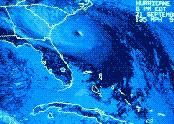
September 13, 2008: Hurricane Ike devastated the Upper Texas Coast, making landfall at Galveston during the early morning hours of September 13. As the center of the storm passed through Anderson County, sustained winds of 50 mph rapidly diminished to near-calm. Ike's winds blew down numerous trees and caused power outages throughout East Texas. A special report is available here!
-
September 7-8, 2010: After making landfall along the northern gulf coast of Mexico on the 6th, the remnants of Tropical Storm Hermine moved through the western portions of North Texas dropping several inches of water in some locations and producing 8 tornadoes. Significant flash flooding occurred during the late evening hours of September 7th through September 8th. Up to 12 inches of rain fell across the area with the highest totals along the Interstate 35 corridor. Numerous high water rescues and evacuations were conducted across the region. On September 8th, an EF2 tornado moved through the western city limits of Dallas, injuring one person. Just prior to the Dallas tornado, an EF1 tornado moved through Seagoville in the southeastern portions of Dallas County. Two fatalities occurred during the event due to the flooding.
-
June 18, 2015: Tropical Storm Bill made landfall on Matagorda Island on June 16th. By the 18th, Tropical Depression Bill had moved north, near the I-35 corridor, and had brought flooding to parts of North Texas. The counties that experienced the most significant flooding were Wise and Montague, and the northern parts of Parker County. Over a foot of rain fell in parts of Montague County. The ground in many areas was still saturated from heavy rainfall in April and May , and the heavy rainfall from TD Bill quickly overflowed creeks, streams, lakes, and roads. In some areas it took over 24 hours for the water to drain. There was one fatality, from drowning, during this event in Bell County.
-
July 8, 2024: On July 2, Hurricane Beryl reached Category 5 strength over the Caribbean Sea, the earliest ever in a season for a Category 5 storm in the Atlantic basin. Beryl made landfall near Matagorda Beach on July 8 as a Category 1 storm. Portions of East Texas experienced flooding rains and damaging winds. Palestine recorded a peak wind of 47 mph.
 For additional information about Hurricanes and Tropical Storms, please visit the National Hurricane Center! For additional information about Hurricanes and Tropical Storms, please visit the National Hurricane Center!
|


