|
North and Central Texas Snowfall Events for Winter 2009-2010
|
| |
|
Winter 2009-2010 will be remembered by many as one of the snowiest winters in North Texas in quite some time. The official site for the Metroplex, D/FW Airport, recorded 17.1 inches of snowfall making it the 2nd snowiest season on record. Some locations had even more snow, with a few spots having 25 inches or more. Central Texas had considerably less snow.
Also of interest was how there was very little freezing rain during the season. Typically North and Central Texas will have one or two ice events during the winter months, but not this year.
|
D/FW Snowiest Seasons
1   17.6   1977-78
   2   17.1   2009-10*
   3   15.3   1963-64
   4   13.5   1923-24
   5   10.4   1976-77
   6    9.5   1909-10
   7    9.2   1916-17
   8    8.8   1947-48
   9    8.1   1937-38
  10    7.3   1965-66
        7.3   1941-42
|
So why was this winter so snowy and cold for parts of North Texas? In two words, "El Nino." The return of El Nino is the main factor in this winters weather pattern. El Nino typically brings cooler and wetter conditions to much of Texas, as seen in the graphic to the right.
Scroll down the page to see more information on the bigger snowfall events during the winter.
|
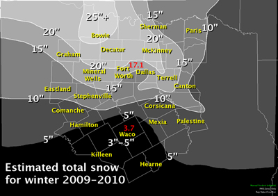
Winter Season 2009-2010 Total Snowfall Map
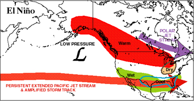
Typical Cold Season El Nino Patterns for North America
|
|
|
December 2nd, 2009
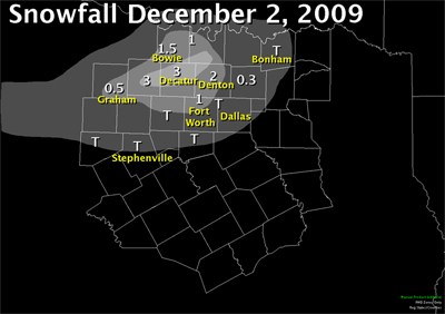
An upper level low pressure system moved across north Texas in the early morning hours of December 2. Temperatures in the upper levels became just cold enough for a transition from rain to all snow across the northwestern parts of north Texas, even though surface temperatures were above freezing.
Snow fell hard enough to offset the rate of melting, and locations across Jack, Wise, and Cooke county received 2-3 inches of snow accumulation. Skies rapidly cleared by the mid-morning hours and sunshine and warmer temperatures melted almost all of the snow by noon.
|
 |
|
| December 4th, 2009
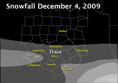
An upper level disturbance moved across Central Texas and produced light snow across the areas of central and southeast Texas. A very dry air mass near the surface limited the snowfall intensity and amounts, and no one in North or Central Texas received more than an inch with this system.
Heavier snow fell in the Houston area where they recorded their earliest measurable snowfall on record.
|
 |
|
|
Christmas Eve 2009 Snowstorm/Blizzard
A strong cold front moved into North Texas late on the 23rd; sweeping through and south of the region during the early morning hours on the 24th. Winter Storm Warnings and Winter Weather Advisories were issued late in the evening on the 23rd, as data suggested the low would move further south across the region. The more southern movement of the low would allow the colder air to deepen enough for the precipitation to fall as all snow.
Light rain began to change over to light snow in Graham and Mineral Wells between 5 and 6 am on the 24th. This transition to snow progressed southeast during the morning hours, with the northwestern third to half of North Texas changing over to all snow during the early afternoon.
Northwest winds from 20 to 40 mph brought blizzard to near blizzard conditions to much of the region through the evening hours on the 24th. Wind advisories were out for the region, and a High Wind Warning was even issued for northwestern sections. Most of the snow had ended by 10 pm on Christmas Eve, but not before dropping 1 to 9 inches.
|
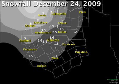
Total Snowfall Map From December 24th, 2010 Snowstorm
|
|
Lows Christmas morning were in the 20s, so the snow stuck around and many enjoyed their first ever white Christmas in North Texas.
|
| December 29th, 2009
With a cold air mass in place, a weak upper level disturbance from the Pacific moved over north Texas. Precipitation began as light rain and sleet by midday and transitioned to light snow over northwest of a Lampasas to Hillsboro to Paris line where temperatures were near freezing.
The highest accumulations of 1-2 inches occurred in the Northwestern parts of North Texas where the coldest temperatures were located.
|
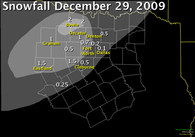
Total Snowfall Map From December 29th, 2010 |
|
| February 11th-12th, 2010
Record breaking snow fell across northern portions of North Texas on the 11th and 12th of February. Cold air was already in place across North Texas as a slow moving upper level low approached. The low slowed significantly as it got closer to the region and this allowed relatively warm and moist air to move over the colder air at the surface for an extended period of time.
This very unusual event brought snowfall totals of a foot or more for many locations around the D/FW Metroplex. Haslet reported 14.4 inches, while the D/FW Airport had a record shattering 12.5 inches.
Widespread power outages resulted from the heavy snow weighing down tree limbs and shorting out transmission lines. Clean up from the tree damage lasted for weeks.
|
D/FW Records With This Event
-
Greatest All-Time calendar day snowfall
-
Record daily maximum snowfall for Feb 11th
-
Greatest All-Time 24-Hour snowfall total
-
Record 24-Hour snowfall in February
|
|
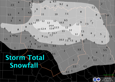
Total Snowfall Map From February 11-12th, 2010 Snowstorm |

NWS Ft. Worth Feb 11th |
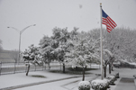
NWS Ft. Worth Feb 11th |
| |
|
|
|
February 14th, 2010
A fast moving cold front brought strong north winds and colder temperatures to the area on Valentine's Day. An upper level low pressure system tracked across the Midwest, and was too far northeast to bring snow to most areas of North Texas.
However, a band of light snow developed along and just north of the Red River during the afternoon with far northern Lamar county registering an inch.
|
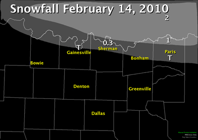
Total Snowfall From February 14th, 2010 |
|
|
February 23rd, 2010
A strong upper level low pressure system tracked across Central Texas and brought some snow to much of the area. The highest accumulations were located south of I-20, closer to where the center of the upper low had tracked.
Snow began in the early morning hours in the west and moved east and southeast during the day. Heavy snow fell across the southern half of North Texas during the late morning and afternoon hours before ending.
|
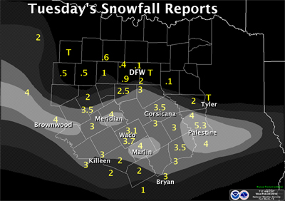
Total Snowfall Map From February 23, 2010 Snowstorm |
|
|
March 20th-21st, 2010
An unusually strong and cold upper level low slowly moved along the Red River Valley on March 20 and 21st. Heavy snowfall occurred on the backside of the slow moving upper low with measurable snowfall occurring mainly to the north of I-20.
A very localized and heavy band of snow developed during the early morning hours of the 21st and dumped 5-9 inches of snow across Collin county. Some locations just 20 miles to the southwest of this band of snow only picked up 1 inch. Snow continued into the early afternoon hours on the 21st across East Texas before ending.
This system also was responsible for a late season freeze across much of North Texas.
|
D/FW Records With This Event
|

McKinney, Tx March 21
|
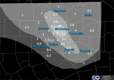
Total Snowfall Map from March 20-21, 2010 Snowstorm
|