Life-threatening and locally catastrophic flash and urban flooding is expected across portions of south-central Texas through early Friday, with significant river flooding and rapid rises on small streams, arroyos, and typically dry washes expected. A significant heat wave continues for the Rockies, Northern Plains, and Great Lakes into the Mid-Atlantic, peaking in intensity through midweek. Read More >
Overview
|
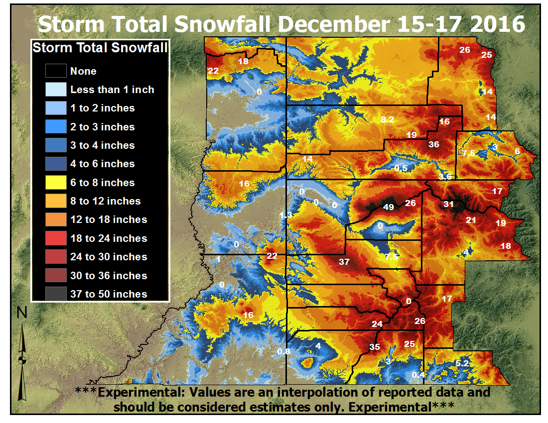
A major winter storm brought several feet of heavy snow to the eastern Utah and western Colorado mountains during the evening of December 15th through the morning of December 17th. Most locations received one to two inches of liquid equivalent precipitation, with measured liquid precipitation equivalence as high as four inches! Both Highway 550 over Red Mountain Pass and Highway 65 over the Grand Mesa were closed for more than 24 hours due to avalanche danger and mitigation during and after this storm. Many accidents along I-70 occurred due to winter weather, and many passes in western Colorado were closed for shorter duration during this storm due to either vehicle accidents or avalanche mitigation. This storm brought snowpack up significantly in water basins across eastern Utah and western Colorado. |
|
 |
 |
 |
 |
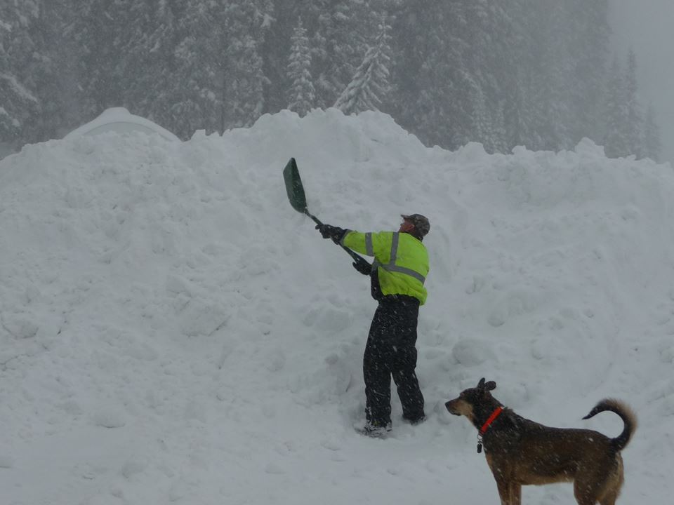
| Digging out from 33" of snow on December 17, 2016. Photo courtesy Grand Mesa Lodge. |
9" fell at Spring Valley, near Glenwood Springs. Photo courtesy Rick Walter |
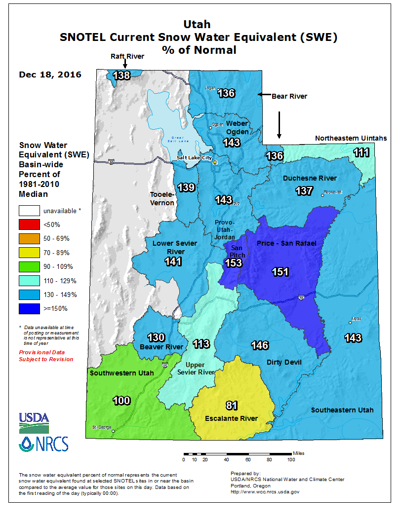
Snow Water Equivalent (SWE) percentage of normal in Utah as of 12/18/2016 |
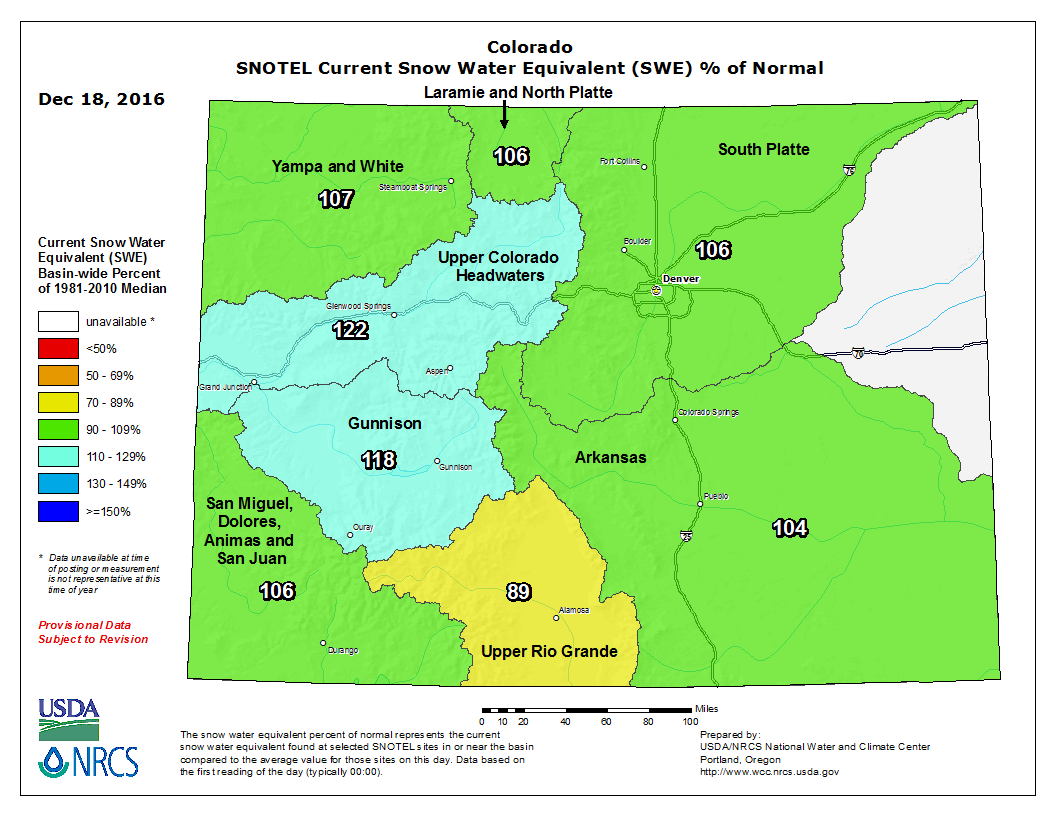
Snow Water Equivalent (SWE) percentage of normal for Colorado as of 12/18/2016 |
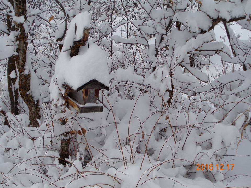
Photos & Video:
Header
 |
 |
 |
 |
| Snow piling up in Ouray, CO on December 17, 2016 (Heather Smith) |
Just north of Ouray, CO on December 17, 2016 (Mary Carkin) |
Buried snowmobile trailer on the Grand Mesa December 17, 2016 (Grand Mesa Lodge) |
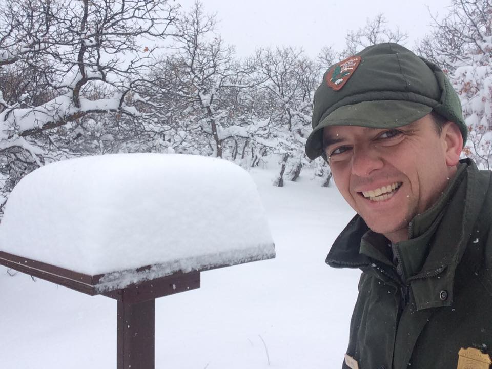
12.5" fell at Black Canyon National Park (NPS) |
Storm Reports
Preliminary and estimated mountain storm total values are shown. This is
followed by individual reports, both 24 and 48 hour values.

Elkheat & Park Range...... 14 to 26 inches
Flattops.................. 12 to 36 inches
Grand Mesa................ 20 to 40 inches with 49 inches near Park Reservoir (9960')
Gore & Elk Range.......... 14 to 19 inches
West Elk & Sawatch Range.. 19 to 31 inches with 49 inches near Schofield Pass (10700')
Uncompahgre Plateu........ 30 to 40 inches
Northwest San Juans....... 16 to 27 inches
Southwest San Juans....... 19 to 35 inches
Eastern Uintas............ 11 to 22 inches
Eastern Tavaputs.......... 14 to 18 inches
La Sals & Abajos.......... 15 to 22 inches


...Snowfall Reports...

Location                     Amount    Time/Date       Elevation (ft.)
Cedaredge 10.5 NNW           33.8 in   0800 AM 12/18   10399
Irwin Ski Lodge              31.0 in   0521 PM 12/17   10400
4 NE North Pole Peak         27.0 in   1201 PM 12/18   9470
Crested Butte 6.2 N          23.5 in   0700 AM 12/18   9606
Gothic                       23.5 in   0700 AM 12/18   9469
Ouray                        21.9 in   0507 PM 12/17   7720
Ouray Spotter                21.9 in   0736 AM 12/18   7727
Ouray                        21.9 in   0736 AM 12/18   7728
Pitkin 1.1 SW                18.0 in   0700 AM 12/18   9139
6 NNW Rockwood               17.9 in   0700 AM 12/18   8976
Taylor Park                  10.4 in   0509 PM 12/17   9179
4 NW Colona                  10.0 in   0507 PM 12/17   null
3 N Skyway                   9.0 in    0642 PM 12/17   7696
Vail 2.6 E                   8.6 in    0700 AM 12/18   8389
Montrose 2e                  7.5 in    0700 AM 12/18   5806
Montrose 7.3 ENE             7.2 in    0700 AM 12/18   6914
Gunnison 6.6 N               6.5 in    0700 AM 12/18   7941
Vail 0.9 WNW                 6.0 in    0700 AM 12/18   8172
Durango 4.8 WSW              5.8 in    0700 AM 12/18   7430
Steamboat Springs 0.7 ESE    5.7 in    0700 AM 12/18   7049
El Jebel                     5.5 in    0720 AM 12/18   6427
Pagosa Springs 1.6 SSW       5.2 in    0800 AM 12/18   7401
Bayfield 7N                  4.4 in    0700 AM 12/18   7460
Hayden                       4.0 in    0600 PM 12/17   6467
Gunnison 3wsw                4.0 in    0700 AM 12/18   7602
Cortez 11nw                  4.0 in    0700 AM 12/18   6598
Carbondale                   3.6 in    0500 AM 12/18   6171
Glenwood Springs 1.7 NW      3.6 in    0700 AM 12/18   6050
Durango 0.8 SSW              3.0 in    0700 AM 12/18   6624
Wolcott 2.3 N                3.0 in    0700 AM 12/18   7224
Wolcott 2n                   3.0 in    0700 AM 12/18   7215
Hotchkiss 5wnw               1.5 in    0700 AM 12/18   5763
17 W Glade Park              1.3 in    0800 AM 12/18   6385
Canyonlands the Neck         1.0 in    0800 AM 12/18   5930
Arboles 5wnw                 1.0 in    0700 AM 12/18   6545
Hovenweep National Monument  0.8 in    0800 AM 12/18   5240
Rifle 3.2 ENE                0.5 in    0700 AM 12/18   5472
Durango 7.1 N                0.5 in    0800 AM 12/18   6575
Rifle 3ene                   0.5 in    0700 AM 12/18   5436
Grand Junction 3.9 SSE       0.5 in    0700 AM 12/18   4676
Ignacio Spotter              0.4 in    0700 AM 12/18   6562
Grand Junction 4.1 W         0.1 in    0700 AM 12/18   4630
 |
Media use of NWS Web News Stories is encouraged! Please acknowledge the NWS as the source of any news information accessed from this site. |
|