
A heat wave over the Southwest will intensify this week, peaking and expanding into the Intermountain West and northern High Plains this weekend. Critical to extremely critical fire weather conditions are forecast from the Northwest and the northern Great Basin this weekend. Particularly Dangerous Situation Red Flag Warnings have been issued. Read More >
Overview
|
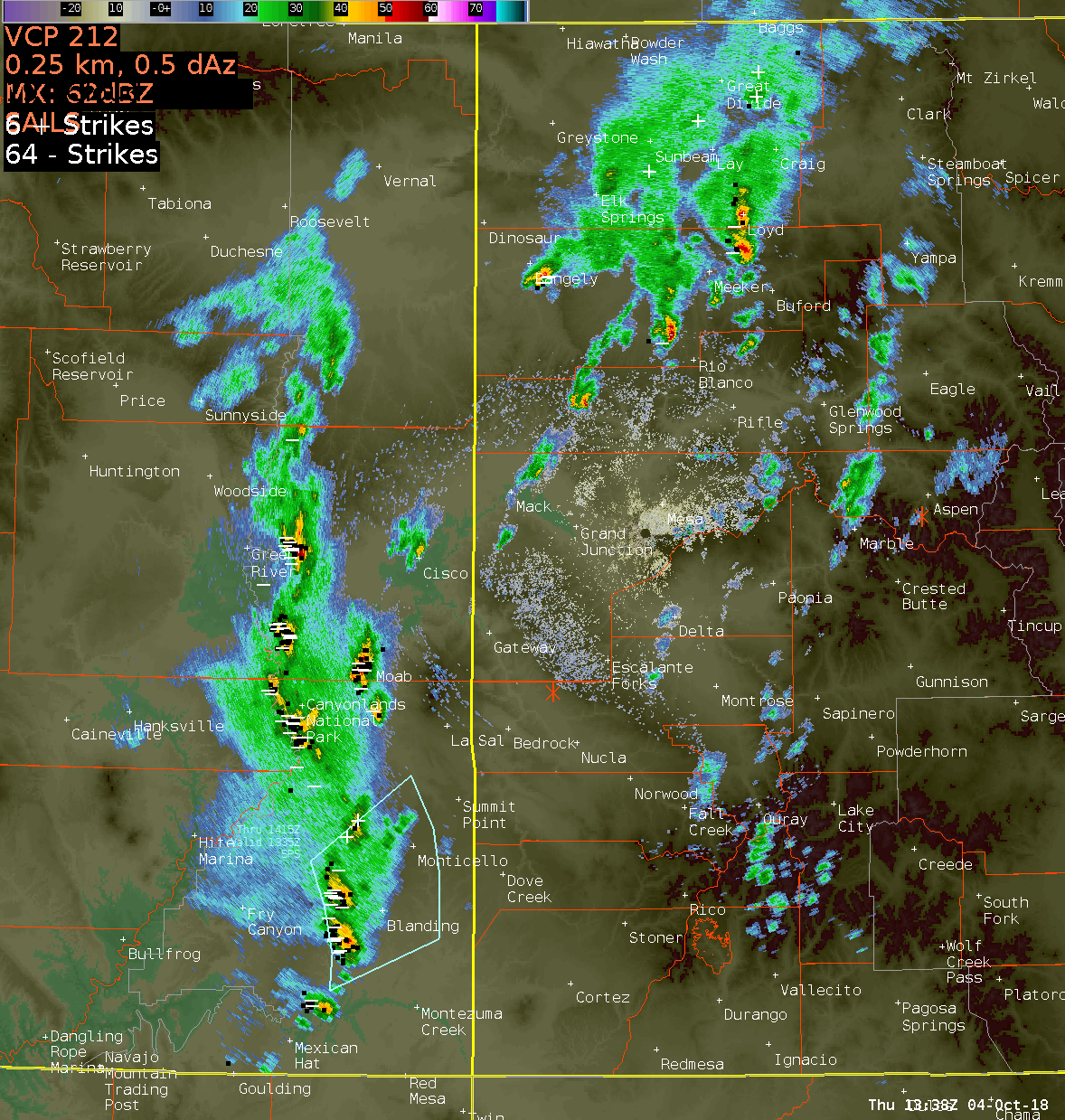
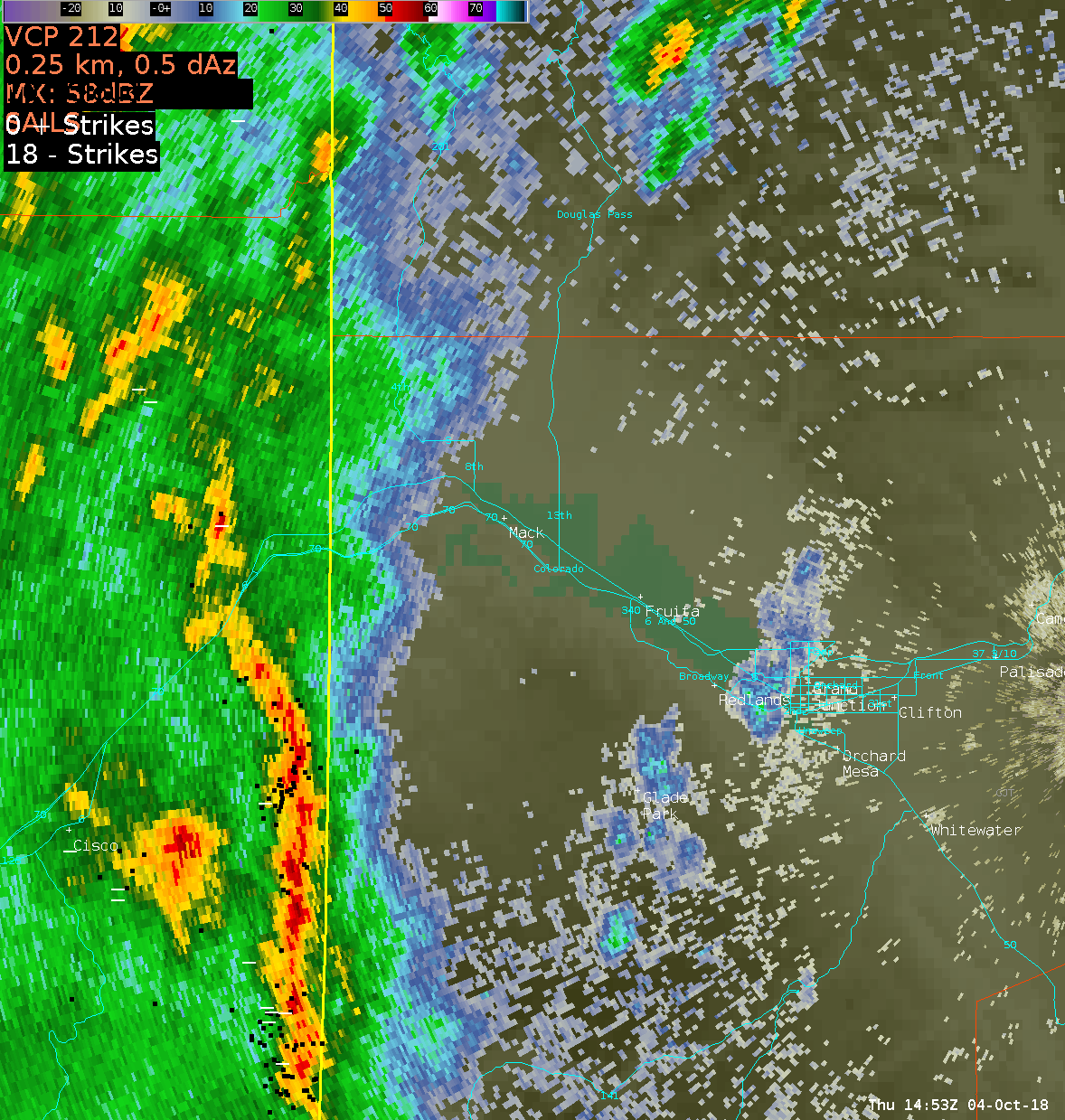
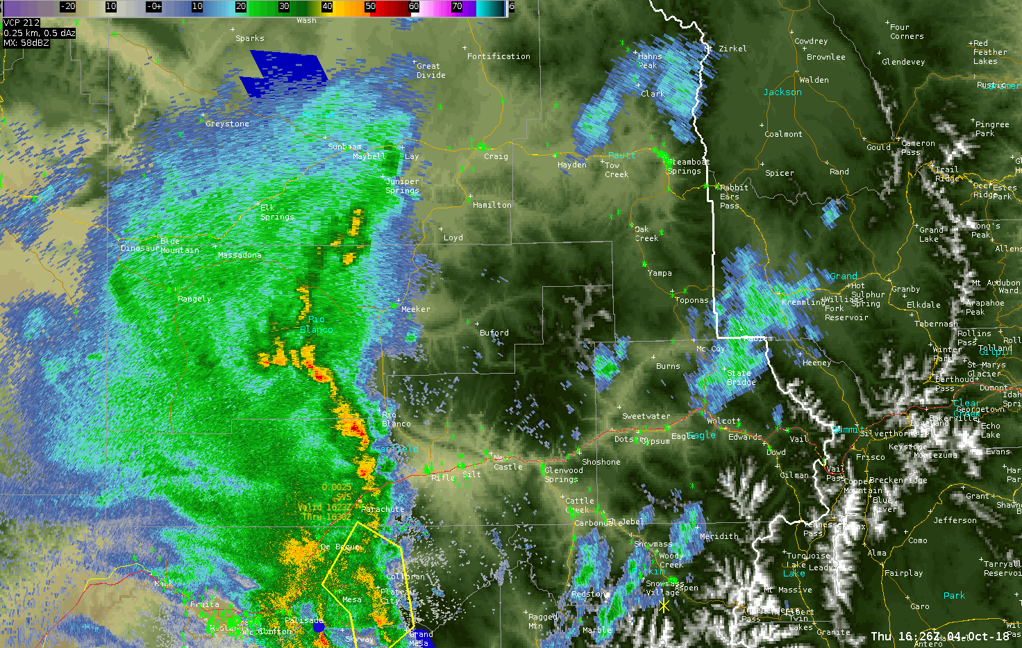
A potent disturbance embedded in southwest flow aloft produced strong thunderstorms which moved across eastern Utah and western Colorado on Thursday, October 4th. The unsettled weather began during the early morning hours when a storm produced quarter-sized hail in Palisade, Colorado around 3:30 AM MDT. Winds associated with thunderstorms throughout the day were very strong and even exceeded Category 1 hurricane strength at times. The peak wind gust on October 4th was 82 MPH which was recorded at the Rifle Garfield County Airport at 10:39 AM MDT. This resulted in some damaging winds with a single engine Cessna aircraft being tipped sideways onto a wing as well as onto its nose. Twenty minutes later, five trees, including two cottonwoods, were knocked down just northwest of Carbondale in Garfield County.
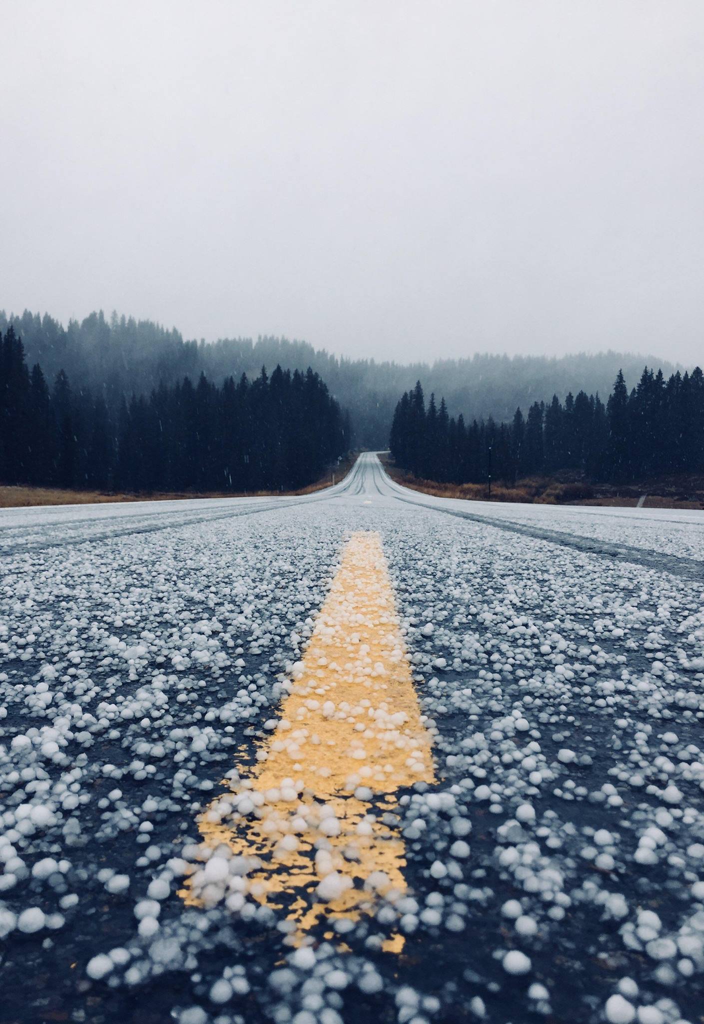
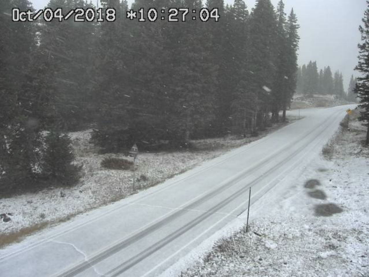
The wild weather that day also allowed the Grand Mesa to see its first snowfall of the season with some light accumulations on Highway 65. |
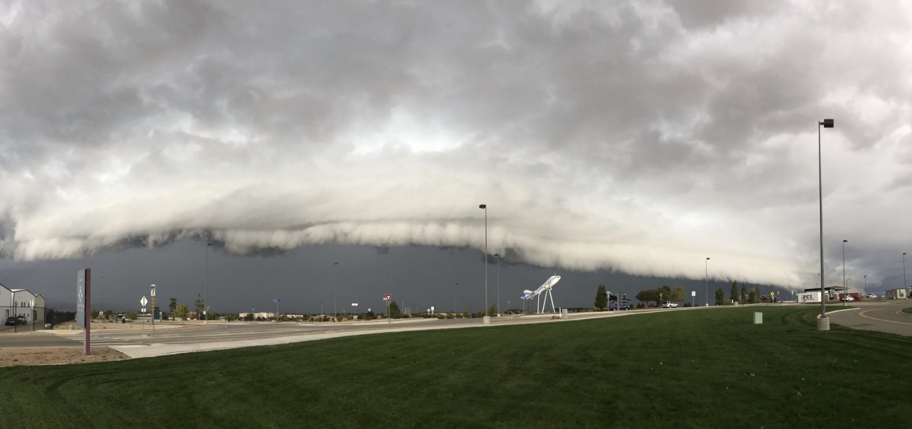 Shelf Cloud Approaches NWS Grand Junction (Credit: Mike Charnick) |
Photos & Video:
 |
 |
| Hail Accumulating on the Grand Mesa (Credit: Rue via KKCO11 News) |
First Snow on the Grand Mesa (Credit: CDOT) |
Radar:
 |
 |
 |
| Line of Storms Crossing Eastern Utah | Severe Storm Moving Through Grand Valley | Storms Moving Through Garfield County |
Storm Reports
Public Information Statement
National Weather Service Grand Junction CO
731 AM MDT Fri Oct 5 2018

A cold front moved through eastern Utah and western Colorado on
Thursday, October 4th. Scattered showers and thunderstorms
accompanied the front with some storms becoming severe. These severe
storms produced gusty outflow winds exceeding 58 MPH and hail almost
three-quarters of an inch in diameter.

...HAIL REPORTS...

Location                     Size      Time/Date       Provider

...Colorado...

...Delta County...
Grand Mesa Lodge             0.70 in   1006 AM 10/04   Public
Hotchkiss 4NW                0.25 in   1030 AM 10/04   Public
Hotchkiss 6NW                0.25 in   1030 AM 10/04   Public

...Mesa County...
Palisade                     1.00 in   0330 AM 10/04   Public
Loma 5NNW                    0.25 in   0930 AM 10/04   Public
Loma                         0.25 in   0940 AM 10/04   Public

...Routt County...
Steamboat Ski Resort         0.25 in   1207 PM 10/04   Public

...Utah...

...Grand County...
Moab 1W                      0.25 in   0815 AM 10/04   Public

...WIND REPORTS...

Location                     Speed     Time/Date       Provider

...Colorado...

...Delta County...
Jay, Hotchkiss 3NNW          70 MPH    1052 AM 10/04   RAWS

...Garfield County...
Garfield County Rgnl AP      82 MPH    1041 AM 10/04   ASOS
Rio Blanco 2ESE              81 MPH    1031 AM 10/04   CODOT
Silt 1WSW                    67 MPH    1054 AM 10/04   CODOT
Douglas Pass                 64 MPH    1005 AM 10/04   Dept of Highways
Douglas Pass                 62 MPH    0115 PM 10/04   CODOT
Silt                         61 MPH    1055 AM 10/04   Trained Spotter

...Mesa County...
1 WNW Fruita                 65 MPH    0931 AM 10/04   Public
4 NE Cameo                   61 MPH    1005 AM 10/04   Mesonet
Mack 5NW                     56 MPH    0922 AM 10/04   Trained Spotter
Grand Jct. Redlands          45 MPH    0930 AM 10/04   Public
Mesa 1.5W                    40 MPH    1020 AM 10/04   Fire Dept/Rescue

...Utah...

...San Juan County...
Valley of the Gods           42 MPH    0734 AM 10/04   CO-OP Observer

...RAINFALL REPORTS...

Location                     Amount    Time/Date       Provider

...Colorado...

...Archuleta County...
Sandoval Mesa, Arboles 7NE   0.07 in   0212 PM 10/04   RAWS
4 NE Arboles                 0.04 in   0134 PM 10/04   RAWS
Chimney Rock 4ENE            0.03 in   0221 PM 10/04   CWOP
Pagosa Springs 15.0SSE       0.02 in   0900 AM 10/04   COCORAHS
Pagosa Springs 1SE           0.02 in   0830 AM 10/04   COOP

...Delta County...
Paonia                       0.09 in   0159 PM 10/04   CWOP
Cedaredge 1.0NE              0.09 in   0800 AM 10/04   COCORAHS
Cedaredge 1.0NE              0.09 in   0800 AM 10/04   COCORAHS
Whitewater 11SSE             0.08 in   0203 PM 10/04   CWOP
Cedaredge 1NNW               0.08 in   0159 PM 10/04   CWOP
Orchard City                 0.05 in   0200 PM 10/04   USGS
Paonia 2WSW                  0.01 in   0200 PM 10/04   HADS

...Dolores County...
Salter, Dolores 12NNW        0.04 in   0224 PM 10/04   RAWS

...Eagle County...
Vail 19SSW                   0.08 in   0229 PM 10/04   CWOP
Avon                         0.07 in   0235 PM 10/04   CWOP
Eagle 13SSE                  0.06 in   0225 PM 10/04   UCN
Dowd Junction                0.05 in   0156 PM 10/04   RAWS
Carbondale 5.7E              0.04 in   0750 AM 10/04   COCORAHS

...Garfield County...
Glenwood Springs             0.07 in   0200 PM 10/04   HADS
Glenwood Springs             0.07 in   0200 PM 10/04   HADS

...Gunnison County...
Crested Butte                0.80 in   0214 PM 10/04   CODOT
Taylor Park                  0.05 in   0200 PM 10/04   COOP
Mount Crested Butte          0.05 in   0224 PM 10/04   CWOP
Taylor Park, Tincup 13NW     0.03 in   0157 PM 10/04   RAWS
Crested Butte                0.03 in   0200 PM 10/04   HADS
Sapinero 3ENE                0.03 in   0145 PM 10/04   HADS
Gunnison                     0.02 in   0800 AM 10/04   COCORAHS
8 NNW Iola                   0.02 in   0119 PM 10/04   RAWS
Almont 1WSW                  0.01 in   0200 PM 10/04   HADS
Gunnison 3WSW                 T in     0800 AM 10/04   COOP

...La Plata County...
Vallecito 7NNE               0.09 in   0145 PM 10/04   USGS
Durango                      0.08 in   0800 AM 10/04   COCORAHS
Big Bear Park                0.07 in   0155 PM 10/04   RAWS
Bayfield 3ESE                0.05 in   0235 PM 10/04   CWOP
Durango 7.1N                 0.04 in   0745 AM 10/04   COCORAHS
Ignacio 4NE                  0.04 in   0145 PM 10/04   USGS
4 WNW Bayfield               0.04 in   0140 PM 10/04   RAWS
3 N Durango                  0.02 in   0808 AM 10/04   COCORAHS
Redmesa 3NW                  0.02 in   0220 PM 10/04   CWOP
Durango                      0.01 in   0820 AM 10/04   COOP
Durango                      0.01 in   0820 AM 10/04   COOP

...Mesa County...
Grand Jct. Redlands          0.32 in   0700 AM 10/05   Trained Spotter
Palisade                     0.32 in   0158 PM 10/04   CWOP
Gateway                      0.09 in   0900 AM 10/04   COOP
1 E Grand Junction           0.08 in   0230 PM 10/04   CWOP
Collbran                     0.06 in   0800 AM 10/04   UCOOP
Fruitvale                    0.06 in   0730 AM 10/04   COCORAHS
Collbran                     0.06 in   0800 AM 10/04   UCOOP
Grand Junction Rgnl AP       0.05 in   1053 AM 10/04   ASOS
Grand Junction Rgnl AP       0.05 in   1053 AM 10/04   ASOS
Fruitvale 1W                 0.04 in   0215 PM 10/04   CWOP

...Moffat County...
Craig 2SE                    0.68 in   0200 PM 10/04   GOES
Ladore, Greystone 11NW       0.09 in   0223 PM 10/04   RAWS

...Montezuma County...
Cortez Municipal Airport     0.08 in   1053 AM 10/04   ASOS
Dolores                      0.06 in   0228 PM 10/04   CWOP
Mancos 3NW                   0.06 in   0130 PM 10/04   HADS
Morefield, Mancos 7WSW       0.06 in   0140 PM 10/04   RAWS
Cortez                       0.04 in   0215 PM 10/04   UPR
Chapin Mesa 3N, M Verde NP   0.03 in   0230 PM 10/04   RAWS
Yellow Jacket 1NW            0.03 in   0800 AM 10/04   COCORAHS

...Montrose County...
6 WSW Montrose               0.06 in   0825 AM 10/04   COCORAHS
Black Canyon                 0.05 in   0157 PM 10/04   RAWS
Black Canyon                 0.05 in   0157 PM 10/04   RAWS
7 SSW Olathe                 0.04 in   0227 PM 10/04   CWOP
Montrose Rgnl Airport        0.03 in   1053 AM 10/04   ASOS
Olathe 1W                    0.02 in   0158 PM 10/04   CWOP

...Ouray County...
Ridgway 1NNW                 0.07 in   0200 PM 10/04   HADS
Ouray 3NNW                   0.04 in   0215 PM 10/04   HADS
Colona 2SSW                  0.01 in   0215 PM 10/04   HADS
Ridgway                      0.01 in   0825 AM 10/04   COOP
Camp Bird 2WNW                T in     0215 PM 10/04   HADS

...Pitkin County...
Aspen-Pitkin Cnty Airport    0.01 in   1053 AM 10/04   ASOS

...Rio Blanco County...
Rangely 1E                   1.23 in   0200 PM 10/04   COOP
Buford 12WSW                 0.06 in   1124 AM 10/04   RAWS

...Utah...

...San Juan County...
Monticello 5SSE              0.08 in   0217 PM 10/04   CWOP
Monticello no. 2             0.05 in   0740 AM 10/04   COOP

...Uintah County...
Vernal                       0.52 in   0220 PM 10/04   AWS

Observations are collected from a variety of sources with varying
equipment and exposures. We thank all volunteer weather observers
for their dedication. Not all data listed are considered official.
 |
Media use of NWS Web News Stories is encouraged! Please acknowledge the NWS as the source of any news information accessed from this site. |
|

