Widespread, life-threatening considerable flash flooding is expected in south-central Texas through at least Friday. Catastrophic river flooding and rapid rises on small streams, arroyos, and typically dry washes are expected in the Texas Hill Country. Wildfire smoke is impacting air quality across much of the Great Lakes region into the Northeast U.S. with Air Quality Alerts in effect. Read More >
Moderate to severe drought conditions covered much of the state of Colorado by the end of May 2012, and worsened considerably throughout the summer months. By late summer and early fall, severe to exceptional drought conditions were felt across much of Colorado. Leading up to these widespread severe to exceptional drought conditions, mountain snowpack for the winter of 2012 was at historically low levels. These near record low snowpack levels and resultant below normal runoff, in addition to below normal precipitation and above normal temperatures throughout the late spring, summer and early fall, contributed to the elevated drought conditions across the state and areas beyond just Colorado. High wildland fire danger, significant agricultural impacts, and water shortages and restrictions were all being realized by the end of June across Colorado.
Many record high temperatures were also set during the summer months, especially June. June of 2012 was the hottest June in Denver since weather records began back in 1872. Many areas in western Colorado also saw record high temperatures including several 100 degree days. This record breaking and triple digit heat was felt statewide. Denver had a total of seventeen 90 degree days and a stretch of five consecutive 100 degree days during the month of June. On two of these days, Denver tied it’s all-time record high of 105°F. On the western slope, Grand Junction saw eighteen 90 degree days and six 100 degree days in Grand Junction during the month of June. To put it in perspective, the normal high temperature in Denver during the month of June is 82 degrees on average, making high temperatures in June 2012 some 10 to 20 degrees above normal. On the other side of the divide, the normal high temperature in Grand Junction during the month of June is 88 degrees on average, making high temperatures in June 2012 some 8 to 12 degrees above normal which is still very hot for this time of year.
Some relief to the hot and dry conditions were seen in early July across western Colorado due to an early onset of monsoonal moisture with several stations reporting above normal precipitation for the month of July. This was short-lived though as hot and dry conditions returned by August and persisted into September with most of the area reporting well below normal precipitation, resulting in little change to the severe to extreme drought conditions and high wildland fire danger.
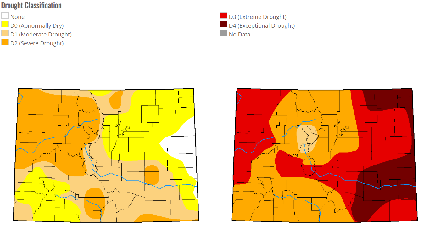
Map showing the change in drought conditions through the Summer of 2012. Map on left is the state of the drought as of May 1, 2012; the map on the right is the state of the drought as of Oct 2, 2012. (source: USDA)
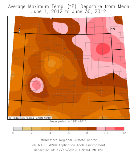
Map showing the average maximum temperature's departure from normal for the month of June 2012. Positive numbers indicate temperatures were above normal. The entire state shows temperatures during the month of June 2012 were above normal on average with northeast Colorado and southwest Colorado seeing the highest departure with maximum temperatures roughly 10 to 12 degrees above normal. (source: MRCC)
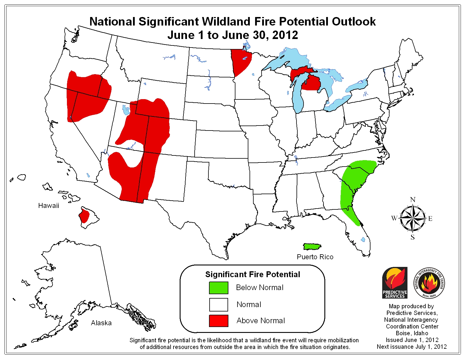
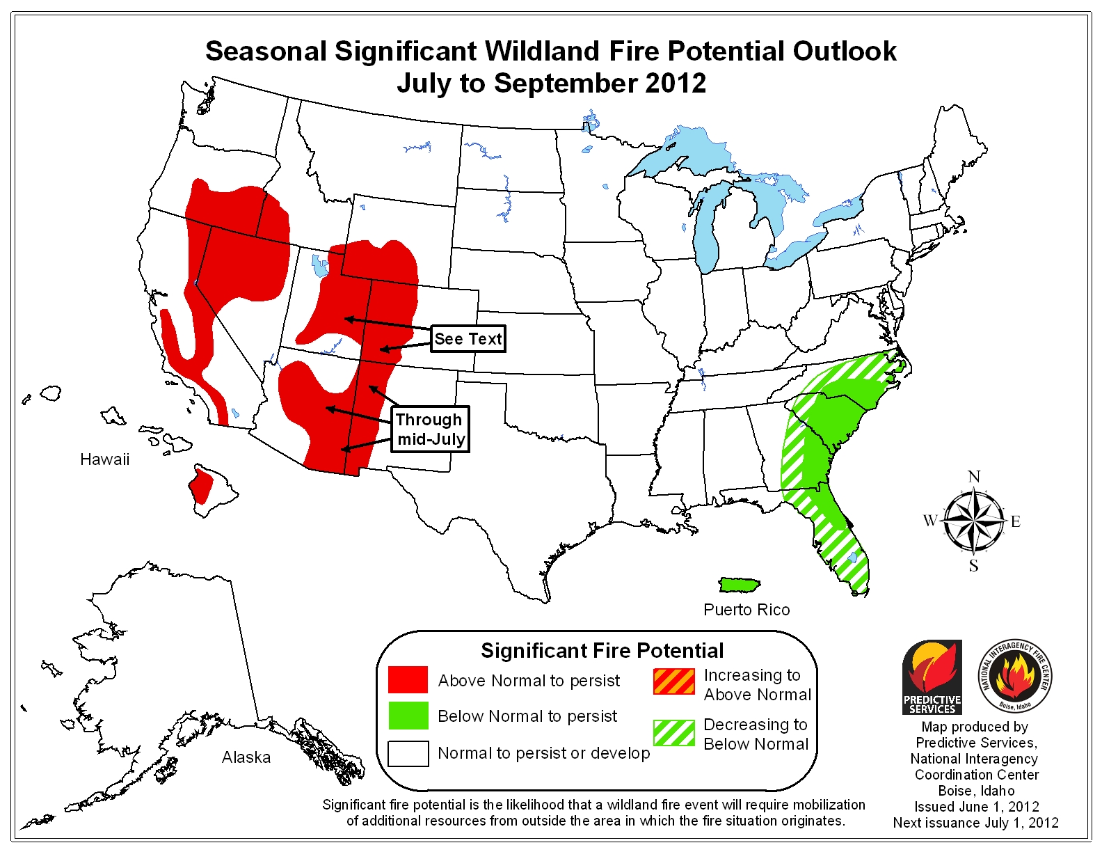
The following two maps below indicate the National Significant Wildland Fire Potential Outlook for June and then the rest of the summer into the Fall from July through September. These maps go to show the impact the heat and drought had on the wildfire season. (source: NIFC/Predictive Services)