
Widespread life-threatening flash and urban flooding continues in south-central Texas, with considerable flooding impacts possible across central Texas. Wildfire smoke is impacting air quality across much of the Great Lakes region into southern New England and the Mid-Atlantic. Monsoonal thunderstorms may produce isolated to scattered flash flooding across the Southwest into the Great Basin. Read More >
Storm Overview
|
The historic snowstorm that brought over 40 inches of snow to the Western Slope started as a strong and unseasonably cold low pressure system that spun over Nevada and far western Utah the day before Thanksgiving in 1919. This low slowly drifted east before dropping southward into the Four Corners region over the following 2 days. An area of high pressure then set up and hindered the progression of the low pressure which allowed ample moisture to get wrapped around the storm and move into eastern Utah and western Colorado. This occurred from Wednesday, the 26th, through Thanksgiving Day before the storm moved off onto the Plains late Friday, November 28th (Figure 1). Unseasonably cold air accompanied the passage of this storm (Figure 2). Surface temperatures on the 26th were on the mild side with high temperatures ranging from the upper 30s to mid 40s. Colder temperatures moved into the region over the next 24 hours with high temperatures on Thanksgiving Day ranging from the low 20s to mid 30s for the lower elevations (Table 1). Finally, in the wake of the storm on the 28th, high temperatures only climbed into the upper teens to the mid 20s for much of the area. A persistent ridge of high pressure left in the storm's wake allowed the cold spell to continue into early December as numerous record low temperatures were set across the region. All signs indicate that what occurred is what we now call an Atmospheric River (AR) Event. The biggest indicator of an AR event is a strong tap of warm, moist Pacific air. During the Thanksgiving 1919 storm this looks to have occurred and led to precipitation falling in the form of rain at times while it was snowing hard at lower elevations. A newspaper article from Ouray, Colorado mentioned that Dallas Divide, sitting at an elevation of nearly 9000 feet, received rain while it was snowing at Montrose and Ridgway. This was found during much of November 1919 as the Desert Southwest ended November with monthly precipitation values up to 5 inches above normal (Figure 3). Several rivers in Arizona also experienced record-breaking flooding which also indicates much higher than normal precipitation. |
.png) Storm Total Snowfall Amounts from Across Eastern Utah and Western Colorado November 26-28, 1919 (NWS) |
Figure 1: Progression of the 500mb Trough November 26-29, 1919:
.jpg) |
.jpg) |
.jpg) |
.jpg) |
| 500mb Geopotential Height (m) on 11-26-1919 (NOAA/ESRL) |
500mb Geopotential Height (m) on 11-27-1919 (NOAA/ESRL) |
500mb Geopotential Height (m) on 11-28-1919 (NOAA/ESRL) |
500mb Geopotential Height (m) on 11-29-1919 (NOAA/ESRL) |
Figure 2: Progression of Cold Air Aloft into the Four Corners Region November 26-28, 1919:
.jpg) |
.jpg) |
.jpg) |
| 700mb Air Temperature (degK) on 11-26-1919 (NOAA/ESRL) |
700mb Air Temperature (degK) on 11-27-1919 (NOAA/ESRL) |
700mb Air Temperature (degK) on 11-28-1919 (NOAA/ESRL) |
Table 1: 24-Hour High Temperature Change Across Eastern Utah and Western Colorado November 26 to 27, 1919:
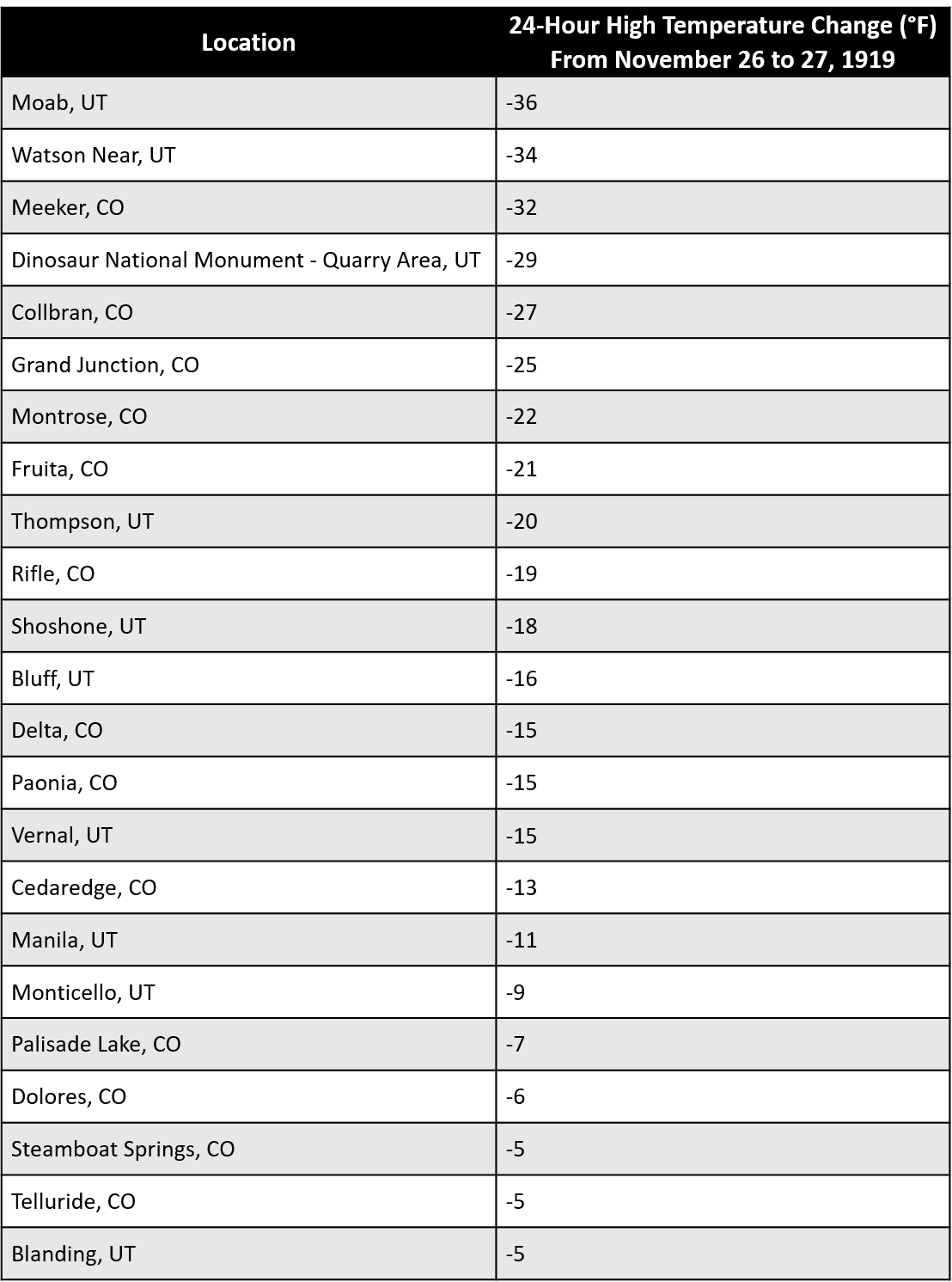
Figure 3: Precipitation Anomaly (in inches) for November 1919:
.png)
Storm Impacts
The National Weather Service in Grand Junction would like to thank the Colorado Climate Center, Uintah County History Center, and the Rifle and Glenwood Springs branches of Garfield County Libraries for their contributions. Additionally, we would like to thank the following newspapers: the Grand Junction Daily Sentinel, Vernal Express, Rifle Telegram, Montrose Daily Press, Glenwood Post, Ouray County Plaindealer, Rio Blanco Herald Times, and both Utah Digital Newspapers and Colorado Historic Newspapers
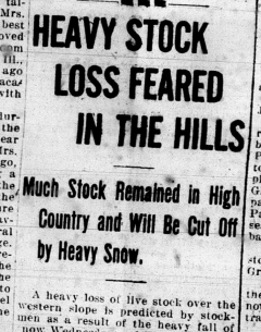
The primary impact to the Western Slope from the Thanksgiving 1919 snow storm was to the livestock industry. Across Mesa, Montrose, Eagle, Garfield, and Rio Blanco counties, archived newspaper clippings from the days following the snow storm continually mentioned the heavy loss to the cattle industry. The pleasant, late fall weather enabled much of the cattle to stay up in the higher elevations longer than normal. Unfortunately, this meant that when the heavy snow came the farmers were unable to bring them down or even feed them.
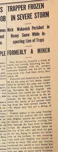
Travel was greatly impacted as a result of the anomalously high snowfall totals. With snow drifts in excess of 10 feet in some places, most roads became impassable. By the evening hours of November 26th, numerous cars were stuck and abandoned in the snow between Montrose and Delta, Colorado. By November 28th, several cars and trucks were snowbound between Rifle and Meeker, Colorado. Additionally, the road from Mack to Palisade and from Palisade to Glenwood Springs in western Colorado was barely passable. The road was closed between Glenwood Springs and Gypsum. On November 29th, all of the roads in Garfield County were closed to automobiles while the road from Eagle to Minturn was impassable after receiving between 18 to 24 inches of snow.
Delayed mail was also a direct result of the hazardous conditions and closed roads. A U.S. mail route from Rifle to Meeker was impacted due to a huge snow drift 12 miles outside of Rifle on November 28th. The mail carrier’s truck became stuck in the snow and attempts to finish the route were made with sleds. It took about a day and a half for Meeker to receive the mail that was intended to be delivered on November 27th.
Significant impacts occurred in Grand Junction throughout the Thanksgiving storm. Schools were closed on November 28th as a result of the deep snow, and the merchants in town abandoned their deliveries for several days. The heavy snow also threatened to collapse the roofs of numerous homes and businesses. However, workers were able to keep up with the snow rates and no collapses were reported. The railway system experienced significant delays with all trains leading to and from Grand Junction running several hours behind schedule on Thanksgiving Day. Trains that were due in the city the afternoon of November 27th did not arrive until later that night.
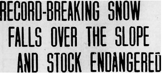
Unfortunately, there was one confirmed fatality that occurred as a result of the Thanksgiving 1919 snow storm. The Glenwood Post reported that a former miner from Aspen who had recently gone into the business of trapping lost his life in the deep snow near Coal Basin, Colorado on November 28th. Several search parties were attempted after he was reported missing but the deep snow hindered efforts. It was not until December 3rd that the body was found. The former miner most likely froze to death.
 |
.png) |
.jpg) |
 |
| Montrose Daily Press Headline on 11-28-1919 (Montrose Daily Press) |
Rifle Reveille Telgram Article on 11-28-1919 (Rifle Telegram) |
Vernal Express Article on 12-5-1919 (Vernal Express) |
Glenwood Post Article on 12-13-1919 (Glenwood Post) |
 |
.jpg) |
 |
 |
| Daily Sentinel Headline on 11-28-1919 (Daily Sentinel) |
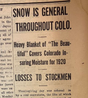
Vernal Express Article on 11-28-1919 (Vernal Express) |
Daily Sentinel Headline on 12-3-1919 (Daily Sentinel) |
Glenwood Post Headline on 11-29-1919 (Glenwood Post) |
 |
Media use of NWS Web News Stories is encouraged! Please acknowledge the NWS as the source of any news information accessed from this site. |
|

