
Flash flooding threatens areas from the Tennessee Valley to the Carolinas as storms repeat along a stalled front. Monsoonal storms may trigger flooding in the Southwest. Dangerous heat expands across the Desert Southwest, Plains, mid-Mississippi Valley and Southern Tier. Critical fire weather for interior Pacific Northwest. Cooler, drier air brings brief relief to the Great Lakes and Northeast. Read More >
Overview
|
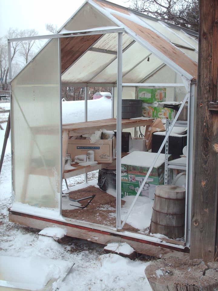
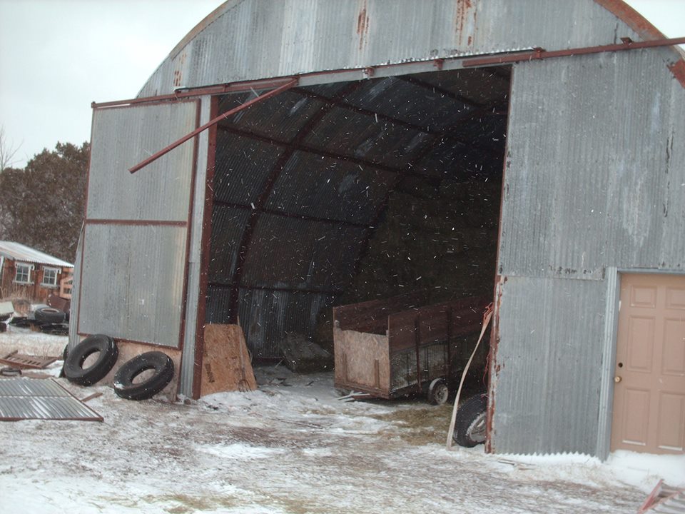
A strong cold front moved through eastern Utah and western Colorado on Sunday through Monday, March 5th-6th, bringing very strong winds to the region. Wind advisories had been issued nearly 48 hours in advance of these strong winds reaching the highly populated areas of eastern Utah and western Colorado. The San Juan Mountains in Colorado got hit the hardest, with some locations reaching 100 mph winds! Many valleys recorded wind gusts to 60 mph, which caused some damage to lighter structures such as greenhouses and barns. Check out recorded wind gusts below, and some photos shared with us from this storm. |
 Damage to a barn 5 miles south of Collbran, CO. Photo courtesy Teresa Woodrum Fletcher |
 |
 |
 |
| Damage to a greenhouse 5 miles south of Collbran, CO. Photo courtesy Teresa Woodrum Fletcher. | Damage to a barn 5 miles south of Collbran, CO. Photo courtesy Teresa Woodrum Fletcher. | Tree down in Carbondale after the early morning strong wind gusts. Photo courtesy Nathan Baier. |
Wind:
...Wind Reports above 40 mph...

Location                     Speed     Time/Date       Lat/Lon
Eagle Mountain               119 MPH   0300 AM 03/06   37.88N/107.74W
Senator Beck                 107 MPH   0400 AM 03/06   37.91N/107.73W
Monarch Pass                 106 MPH   0453 AM 03/06   38.50N/106.32W
Gold Hill - Telluride Ski Re 104 MPH   0200 AM 03/06   37.90N/107.82W
Kendall Mountain             91 MPH    0300 AM 03/06   37.79N/107.64W
Putney                       80 MPH    0600 PM 03/05   37.89N/107.68W
Telluride Regional Arpt      78 MPH    1255 AM 03/06   37.95N/107.91W
The Crown - 2 SSW Emma       78 MPH    1049 PM 03/05   39.35N/107.09W
Douglas Pass - 26 N Mack     77 MPH    0728 PM 03/05   39.60N/108.81W
9 NNW La Sal                 71 MPH    0800 PM 03/05   38.46N/109.25W
Wildhorse - 25 E East Carbon 69 MPH    0848 PM 03/05   39.55N/109.91W
Upper P.R. Canyon - 28 WNW M 69 MPH    1027 PM 03/05   39.47N/109.29W
Mt Abrahms                   68 MPH    0400 AM 03/06   37.96N/107.65W
Storm King Mountain - 4 WNW  68 MPH    0158 PM 03/05   39.59N/107.40W
Dead Horse - 13 ENE Buford   67 MPH    1257 AM 03/06   40.08N/107.37W
2 SW Great Divide            65 MPH    1046 PM 03/05   40.76N/107.85W
17 SSE Naples                65 MPH    0720 PM 03/05   40.20N/109.35W
Huntsman Mesa - 3 NNE Powder 63 MPH    1148 PM 03/05   38.33N/107.09W
Storm Peak Observatory       63 MPH    1110 PM 03/05   40.46N/106.74W
Diamond Rim - 18 NE Naples   61 MPH    0727 PM 03/05   40.62N/109.24W
Vernal Arpt                  61 MPH    0829 PM 03/05   40.44N/109.51W
14 SE Randlett               60 MPH    0845 PM 03/05   40.05N/109.69W
Dragon Road - 13 SSW Rangely 59 MPH    1118 AM 03/05   39.92N/108.89W
McCook Ridge - 35 NW Mack    59 MPH    1027 PM 03/05   39.63N/109.27W
Bryson Canyon - 19 W Mack    59 MPH    1248 AM 03/06   39.28N/109.22W
Garfield County Regional Arp 59 MPH    0909 PM 03/05   39.53N/107.72W
Porcupine Creek - 6 ENE Topo 58 MPH    0157 AM 03/06   40.10N/106.68W
Grand Junction Regional Arpt 58 MPH    0833 PM 03/05   39.12N/108.52W
Pinto - 18 SE Massadona      57 MPH    0123 AM 03/06   40.02N/108.40W
2 SE Rifle                   57 MPH    0151 AM 03/06   39.51N/107.75W
Kings Point - 26 WSW Hiawath 57 MPH    0926 PM 03/05   40.86N/109.10W
Hangman - 3 NW Burns         56 MPH    0155 AM 03/06   39.92N/106.92W
Jay - 3 NNW Hotchkiss        56 MPH    0352 AM 03/06   38.85N/107.74W
2 ENE Whiterocks             56 MPH    0900 PM 03/05   40.48N/109.91W
Craig - Moffat County Arpt   56 MPH    1201 AM 03/06   40.50N/107.52W
Winter Ridge - 41 WNW Mack   56 MPH    1027 PM 03/05   39.50N/109.56W
Meeker Arpt                  55 MPH    1056 PM 03/05   40.05N/107.89W
Eagle County Regional Airpor 55 MPH    0140 AM 03/06   39.64N/106.92W
Nucla - Hopkins Field Ap     55 MPH    0935 PM 03/05   38.24N/108.56W
Cottonwood Basin - 6 E Escal 55 MPH    0248 PM 03/05   38.57N/108.28W
3 NNW El Jebel               54 MPH    0803 PM 03/05   39.45N/107.12W
Yampa Plateau - 14 SE Naples 54 MPH    0927 PM 03/05   40.28N/109.29W
1 WSW Silt                   54 MPH    1026 PM 03/05   39.54N/107.67W
Jacks Canyon - 15 NW Escalan 53 MPH    0250 PM 03/05   38.75N/108.58W
Delta Airport                53 MPH    0335 AM 03/06   38.79N/108.06W
Montrose Regional Arpt       52 MPH    0222 AM 03/06   38.51N/107.89W
Upper Sand Wash - 41 SE Rand 52 MPH    0827 PM 03/05   39.71N/109.44W
Pine Ridge - 6 NW Cameo      52 MPH    1134 PM 03/05   39.24N/108.38W
1 NE Glenwood Springs        52 MPH    1134 PM 03/05   39.56N/107.31W
Big Indian Valley - 8 ESE La 51 MPH    0820 PM 03/05   38.22N/109.28W
1 S Cameo                    51 MPH    1011 PM 03/05   39.13N/108.32W
Nucla - 1 NNE Naturita       51 MPH    0358 AM 03/06   38.23N/108.56W
Canyonlands Field Arpt       51 MPH    1129 PM 03/05   38.76N/109.75W
Demaree - 16 N Mack          51 MPH    1049 PM 03/05   39.46N/108.88W
Taylor Park - 13 NW Tincup   50 MPH    0357 AM 03/06   38.91N/106.60W
Black Canyon - 9 SW Maher    50 MPH    1257 AM 03/06   38.54N/107.69W
Snowmass                     50 MPH    1122 PM 03/05   39.33N/106.99W
Calico - 4 WNW Elk Springs   49 MPH    1053 PM 03/05   40.38N/108.52W
Hayden                       49 MPH    0155 AM 03/06   40.48N/107.22W
Ladore - 11 NW Greystone     49 MPH    0123 PM 03/05   40.74N/108.84W
Dinosaur NM - 15 WSW Greysto 48 MPH    0922 PM 03/05   40.51N/108.93W
Hunter Creek - 19 W Rio Blan 48 MPH    1118 PM 03/05   39.77N/108.33W
2 NE Shoshone                48 MPH    0118 AM 03/06   39.60N/107.15W
2 S Woody Creek              48 MPH    0200 AM 03/06   39.25N/106.88W
3 W Telluride                47 MPH    0806 PM 03/05   37.94N/107.88W
Gypsum - 3 ESE Sweetwater    46 MPH    0113 AM 03/06   39.69N/106.97W
Avon                         45 MPH    0510 AM 03/06   39.66N/106.55W
Carbondale                   45 MPH    0234 AM 03/06   39.40N/107.22W
4 NW Ridgway                 45 MPH    0319 AM 03/06   38.20N/107.80W
4 E New Castle               45 MPH    0311 AM 03/06   39.57N/107.45W
Dry Lake - 4 NE Steamboat Sp 44 MPH    1156 PM 03/05   40.53N/106.78W
Aspen - Pitkin Cnty Arpt     44 MPH    0529 AM 03/06   39.22N/106.87W
1 SE Maeser                  44 MPH    0800 PM 03/05   40.46N/109.56W
Big Bear Park - 2 ENE Tacoma 44 MPH    1255 AM 03/06   37.50N/107.73W
Cortez Municipal Arpt        44 MPH    0403 AM 03/06   37.30N/108.63W
UT-191 @ Monticello          44 MPH    0220 PM 03/05   37.76N/109.40W
2 N Vernal                   43 MPH    0815 PM 03/05   40.48N/109.54W
18 W Blanding Muni Arpt      43 MPH    0130 AM 03/06   37.56N/109.82W
Palisade                     43 MPH    0900 AM 03/05   39.10N/108.35W
Blanding                     43 MPH    0215 AM 03/06   37.58N/109.48W
Steamboat Lake State Park    43 MPH    0200 AM 03/06   40.78N/107.06W
Little Dolores - 11 W Glade  43 MPH    0849 PM 03/05   38.97N/108.94W
Fort Duchesne                42 MPH    0831 PM 03/05   40.28N/109.86W
1 S Steamboat Springs        42 MPH    1117 PM 03/05   40.46N/106.82W
6 NNE Cameo                  42 MPH    0908 PM 03/05   39.24N/108.27W
Grand Mesa - Skyway Pt       41 MPH    0200 AM 03/06   39.06N/108.06W
1 SSW Grand Junction         41 MPH    0851 PM 03/05   39.07N/108.56W
22 SW Rangely                40 MPH    1000 PM 03/05   39.87N/109.10W
Molas Pass                   40 MPH    0400 AM 03/06   37.75N/107.69W
Cart Creek - 17 ESE Manila   40 MPH    0128 PM 03/05   40.88N/109.42W
Maeser                       40 MPH    0753 PM 03/05   40.46N/109.57W
West Summit                  40 MPH    0700 PM 03/05   38.01N/109.13W
 |
Media use of NWS Web News Stories is encouraged! Please acknowledge the NWS as the source of any news information accessed from this site. |
|

