Grand Junction, CO
Weather Forecast Office
Periods of Light Snow Across the North Today...Dry and Mild for the Weekend
A weak disturbance will move across the region today. This will result in periods of snow, favoring the northern and portions of the central Colorado mountains, through this evening. Accumulations will be light...generally between 2 and 4 inches...and minimal impacts are expected. After this system exits to the east, a strong ridge of high pressure will build over the southwestern U.S. This will keep conditions dry through the weekend with temperatures rebounding back to above normal under mostly sunny skies. Sunday is on track to be the warmest day of the year so far with daytime highs running 5 to 10 degrees above normal. This will be a welcome relief, especially for those lower valleys that have been plagued by inversions the last few weeks.
A stronger Pacific storm will move into the Great Basin late in the weekend with snow showers returning to the area by Monday. There are still some inconsistencies in the models on the timing, track and intensity of this storm but, either way, cool and unsettled weather looks to make a return to the Desert Southwest by mid next week.
Latest Weather Map

Forecast Snowfall Totals

Forecast High Temperatures Today

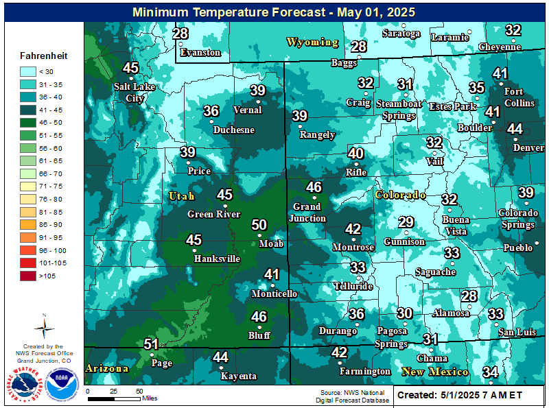
Forecast Low Temperatures Tonight
Hazards
Detailed Hazards Viewer
National Briefing
Outlooks
Transportation Decision Support
Winter Storm Severity Index
Forecasts
Aviation Weather
Fire Weather
Forecast Discussion
Forecast Points
Local Area
Severe Weather
Soaring Forecast
Winter Weather
Hydrology
Recreational River Report
Rivers and Lakes
River Forecast
Weather Safety
Preparedness
NOAA Weather Radio
SkyWarn
Spotter Training Calendar
StormReady
US Dept of Commerce
National Oceanic and Atmospheric Administration
National Weather Service
Grand Junction, CO
2844 Aviators Way
Grand Junction, CO 81506-8644
970-243-7007
Comments? Questions? Please Contact Us.

