
Scattered severe storms are expected in the Midwest this afternoon/tonight, with another threat possible in the central/southern Plains. Late-season snow is expected over parts of the central Rockies including the Denver Metro into Wednesday. Severe thunderstorms are expected Tuesday and Wednesday across Texas and the mid-South, with threats of damaging winds, large hail, tornadoes, and flooding. Read More >
Grand Junction, CO
Weather Forecast Office

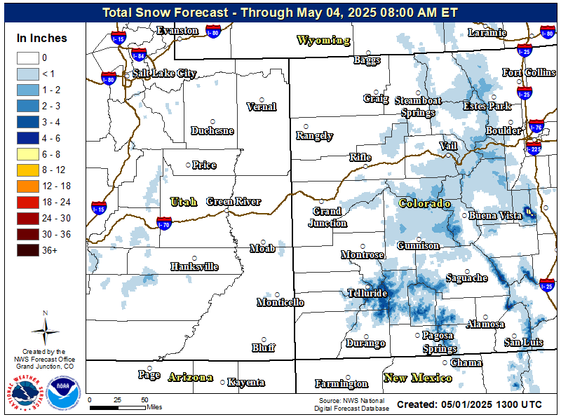
Temperatures will fall to below normal tonight as the first in a series of Pacific storms moves through the region. So, after a period of dry and warm days, a return to cooler and more unsettled weather is expected.
Expect scattered valley rain showers and mountain snow showers tonight with the snow level will lowering to between 6000 and 8000 feet as colder air filters into the area. Snow accumulations in the mountains appear to be in the 4 to 8 inch range on average, with locally higher amounts up to 12 inches above 10,000 feet. Higher valleys may see a changeover to all snow or precip mixing in with snow overnight into early Friday morning, but accumulations appear minimal at best. To summarize the key points from this event:
More rain and snow is expected across the area Saturday night and Sunday!
Hazards
Detailed Hazards Viewer
National Briefing
Outlooks
Transportation Decision Support
Winter Storm Severity Index
Forecasts
Aviation Weather
Fire Weather
Forecast Discussion
Forecast Points
Local Area
Severe Weather
Soaring Forecast
Winter Weather
Hydrology
Recreational River Report
River Forecast
Weather Safety
Preparedness
NOAA Weather Radio
StormReady
SkyWarn
US Dept of Commerce
National Oceanic and Atmospheric Administration
National Weather Service
Grand Junction, CO
2844 Aviators Way
Grand Junction, CO 81506-8644
970-243-7007
Comments? Questions? Please Contact Us.

