A heat wave over the Southwest will intensify this week, peaking and expanding into the Intermountain West and northern High Plains this weekend. Critical to extremely critical fire weather conditions are forecast from the Northwest and the northern Great Basin this weekend. Particularly Dangerous Situation Red Flag Warnings have been issued. Read More >
Drought Information Statement
National Weather Service Grand Junction CO
1058 AM MDT Thu Jul 16 2020
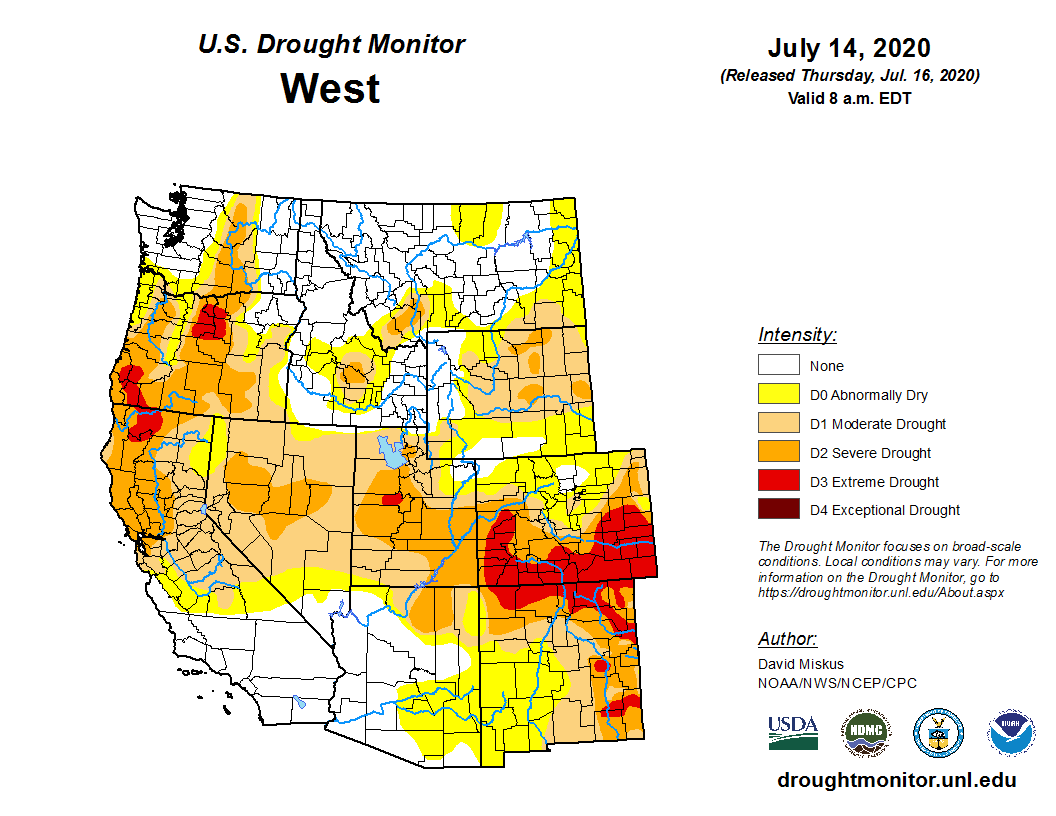
...DROUGHT EXPANDS OVER WESTERN COLORADO...

.SYNOPSIS:
Drought categories have expanded over western Colorado with
extreme drought pushing slightly westward and northward.

Fall precipitation and spring snow accumulation were well below
normal for portions of southwestern Colorado. The dry conditions
have continued for the past few months. Precipitation in the
southern valleys and mountains and west central valleys was below
normal for April and continued to be below normal for the month of
May. June was a mixed bag of some areas above normal and some below.
So far the beginning of July has been dry with well below normal
precipitation and well above normal temperatures.

Areas in D3...Extreme Drought...include Archuleta, San Juan,
La Plata, Delta counties with large portions of Hinsdale,
Montezuma, Dolores, Montrose, San Miguel counties and a smaller
part of eastern Mesa and western Ouray counties.

The increase in drought severity is due to low soil moisture,
lack of snow pack and early melt, below normal precipitation,
lower stream flows, and drying vegetation.

.CLIMATE SUMMARY:
Last fall precipitation was well below normal leading to low soil
moisture content across the southwestern Colorado region going
into the winter season. Snow pack was near normal for the majority
of the winter season but then started to quickly decrease in the
middle of spring. Dry conditions for both the mountains and
valleys in southwestern Colorado and the west central valleys
became entrenched in April and continued through early July. Early
summer rains have been sorely lacking keeping precipitation well
below normal over a large portion of western Colorado.

.HYDROLOGIC SUMMARY AND OUTLOOK:
Average seven day stream flow has ranged from below normal to much
below normal with the 28 day average also ranging from below normal
to much below normal for southwestern Colorado. Flows continued to
quickly decrease to base flow levels early and in many cases are
now running below base flow for this time of year.

.SUMMARY OF IMPACTS:
Impacts include low soil moisture, lower stream flows, and drying
vegetation. Wild fire starts are more prevalent and a few fires in
western Colorado have had large growth characteristics.

.DROUGHT MITIGATION ACTIONS:
None reported.

.PRECIPITATION/TEMPERATURE OUTLOOK:
Into the early summer, there is a better than average chance of
above normal temperatures and better chances of below normal
precipitation across western Colorado.

Current observations show that the ENSO cycle is and will
continue in a neutral condition through the summer. Chances
increase that La Nina will start in the fall.
Latest Drought Monitor (Released July 16th)
Courtesy of National Drought Mitigation Center