Overview
A supercell thunderstorm developed along a rapidly advancing cold front on the evening of May 23rd. This storm produced at least 2 brief tornadoes before transitioning into a large swath of damaging winds north of McCook. The following are the results of several storm surveys conducted by the National Weather Service in Goodland Kansas. These results are preliminary and will likely be adjusted as new information comes in.Tornadoes:
|
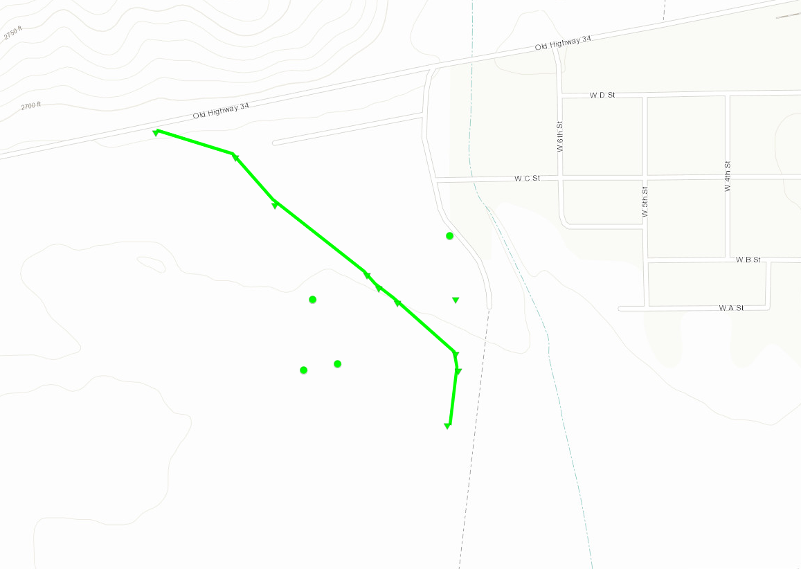
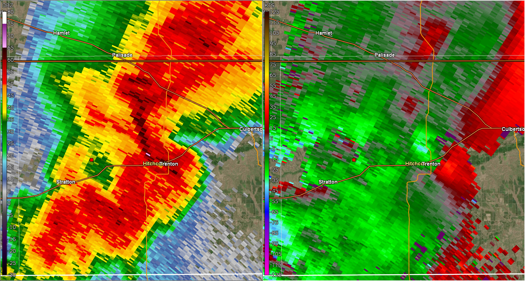
Tornado - Trenton, NE
|
||||||||||||||||
|
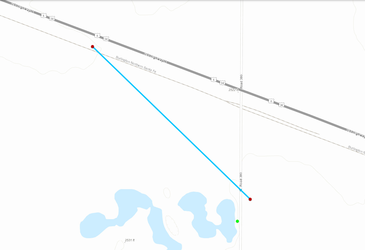
Tornado - 5 West of McCook, NE
|
||||||||||||||||
 |
 |
 |
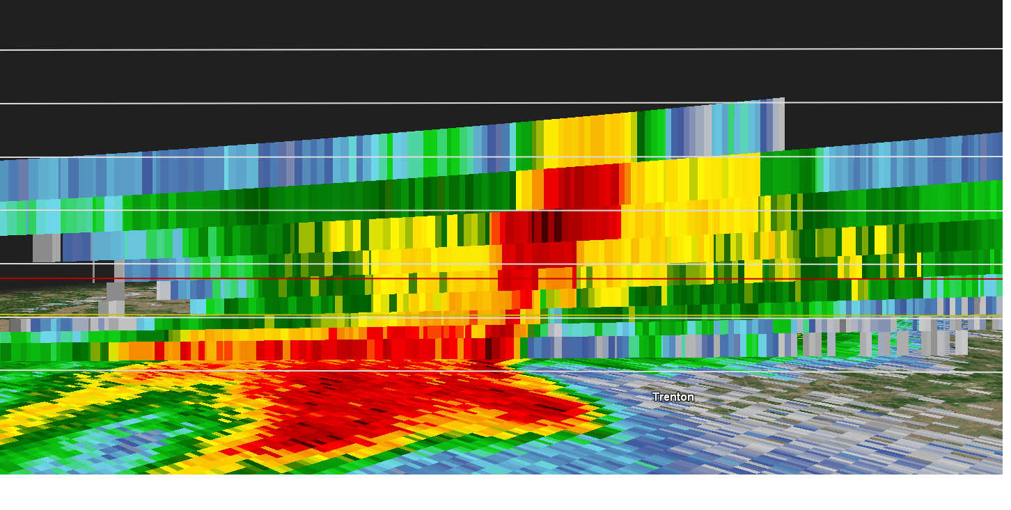 |
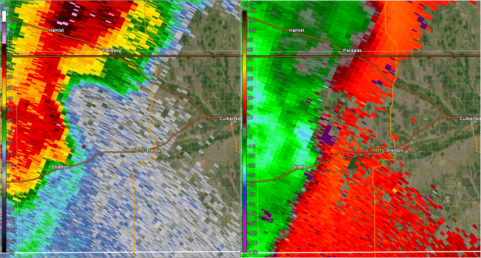
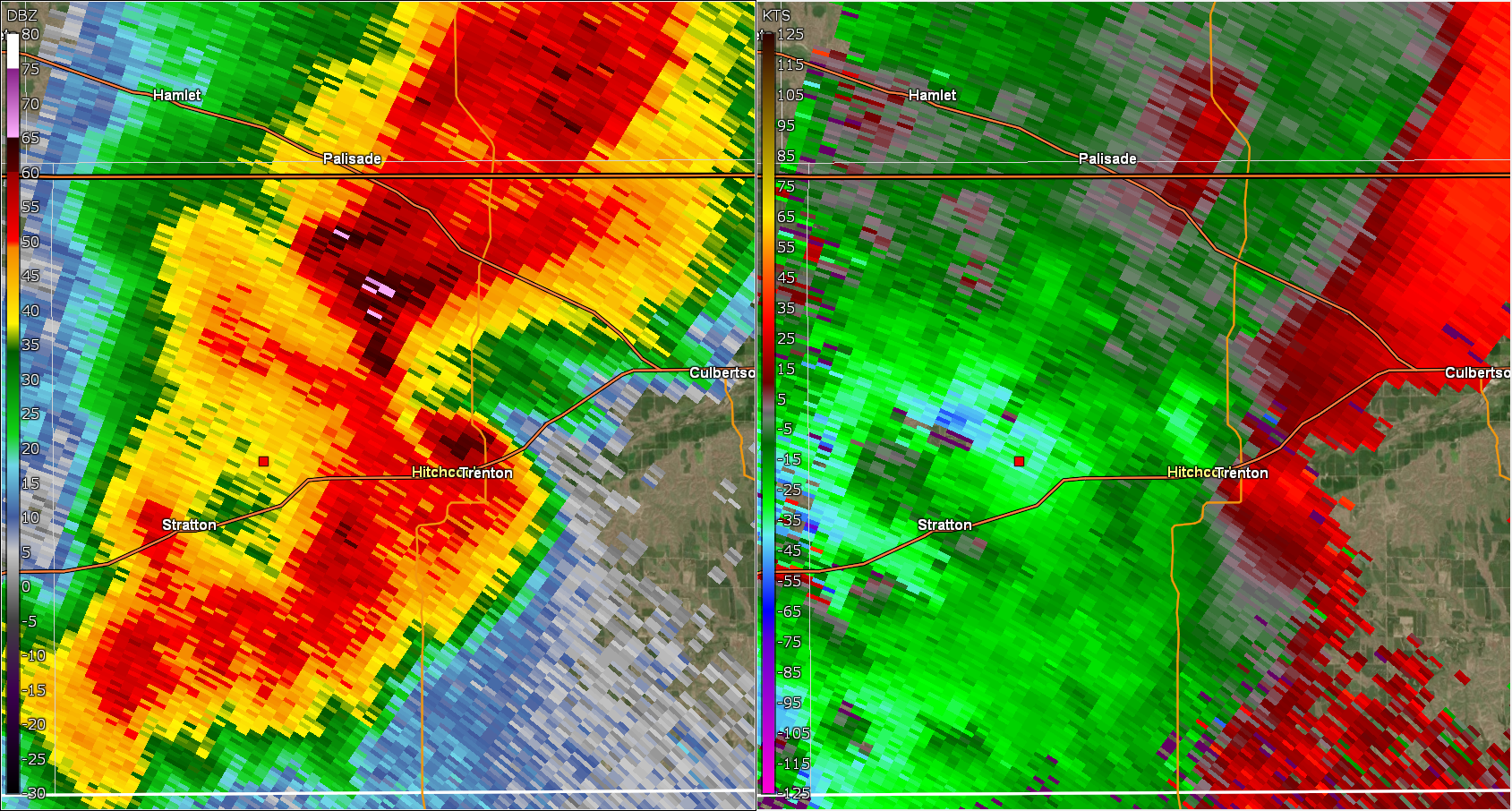
| 844 PM CDT to 915 PM CDT 0.5 Reflectivity and Storm Relative Motion | Estimated start time of Trenton tornado | Rapid intensification of mesocyclone as it moves over Trenton (3 minutes after previous image) | Reflectivity cross section at 901 PM MDT. Image shows updraft area lofting high reflectivity high into atmosphere. |
The Enhanced Fujita (EF) Scale classifies tornadoes into the following categories:
| EF0 Weak 65-85 mph |
EF1 Moderate 86-110 mph |
EF2 Significant 111-135 mph |
EF3 Severe 136-165 mph |
EF4 Extreme 166-200 mph |
EF5 Catastrophic 200+ mph |
 |
|||||
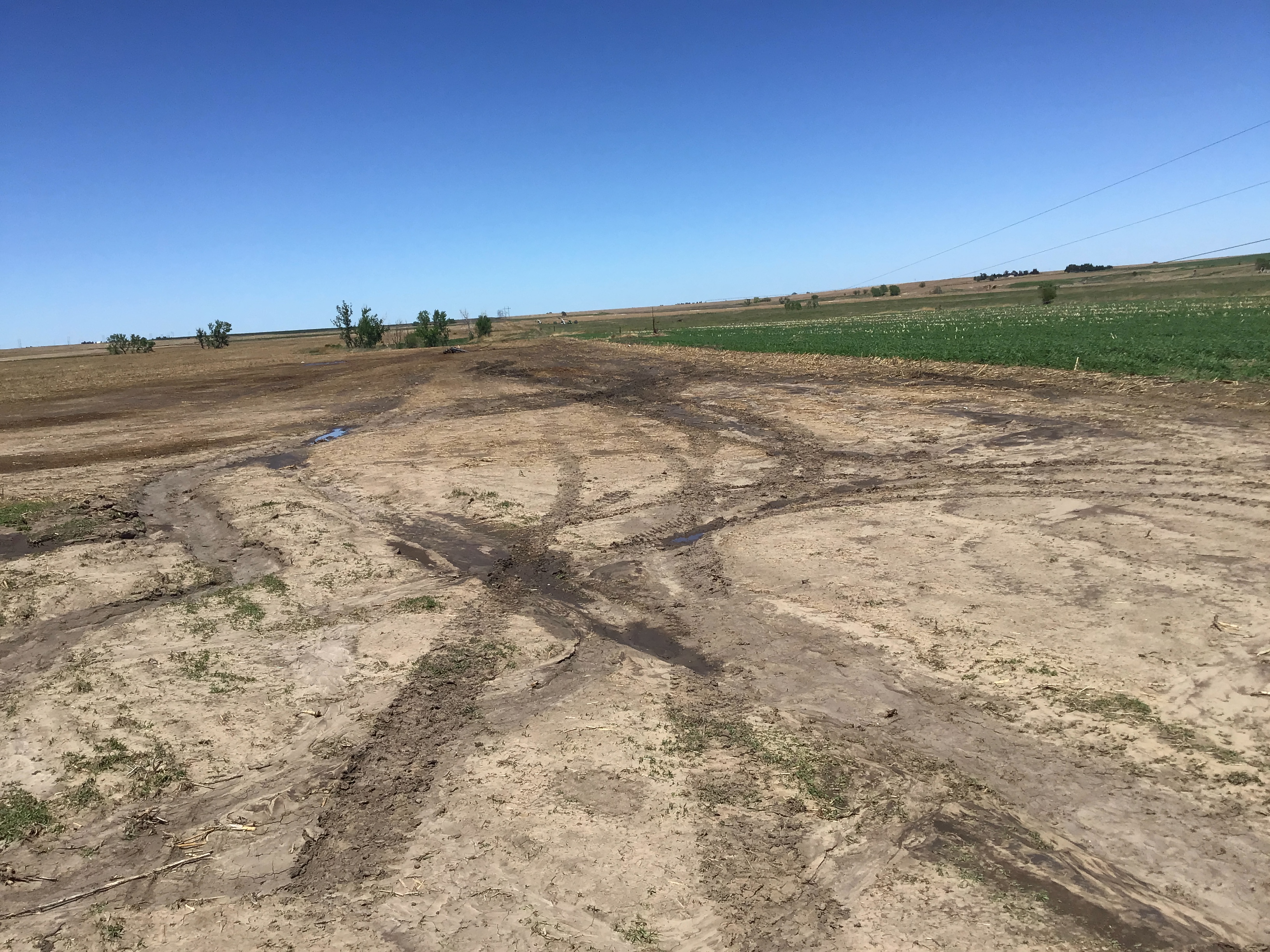
Wind Damage:
Wind
|
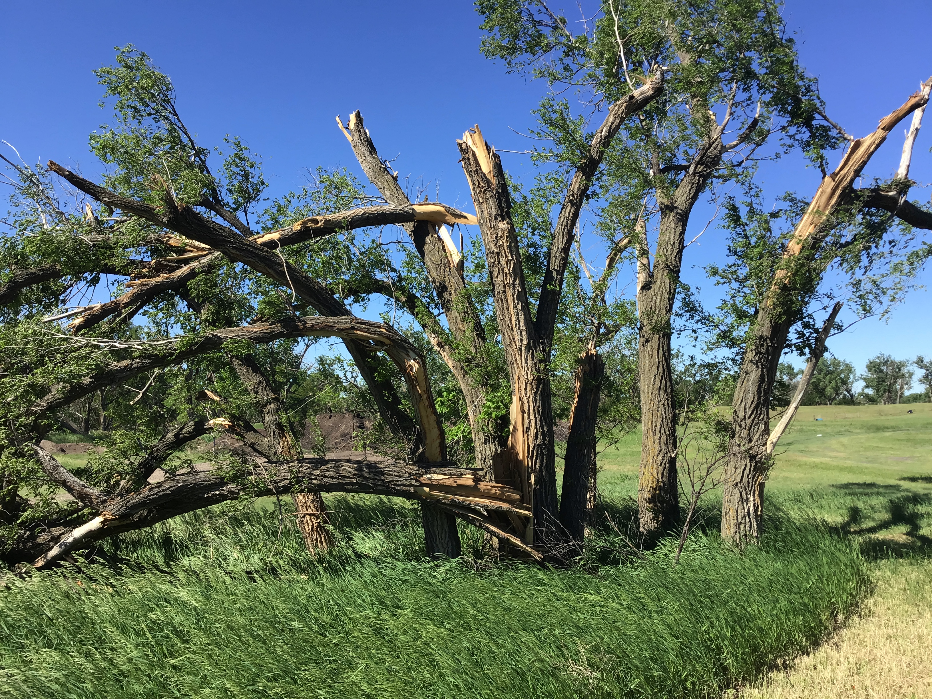
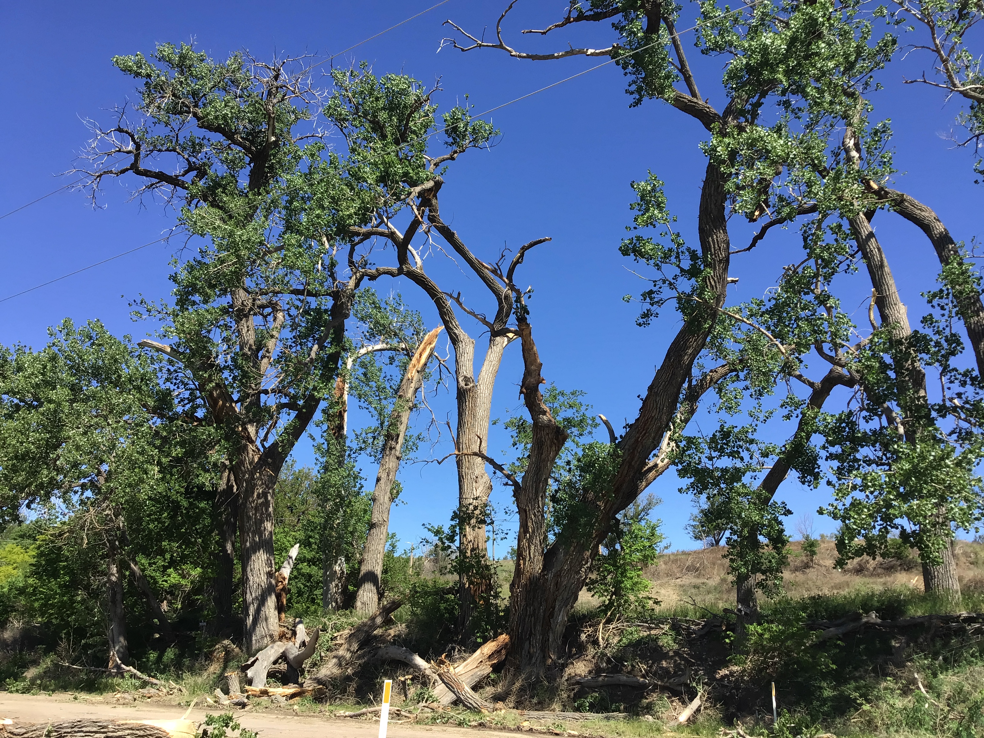
Thunderstorm Wind - 3 NNW of McCook
|
||||||||||||||
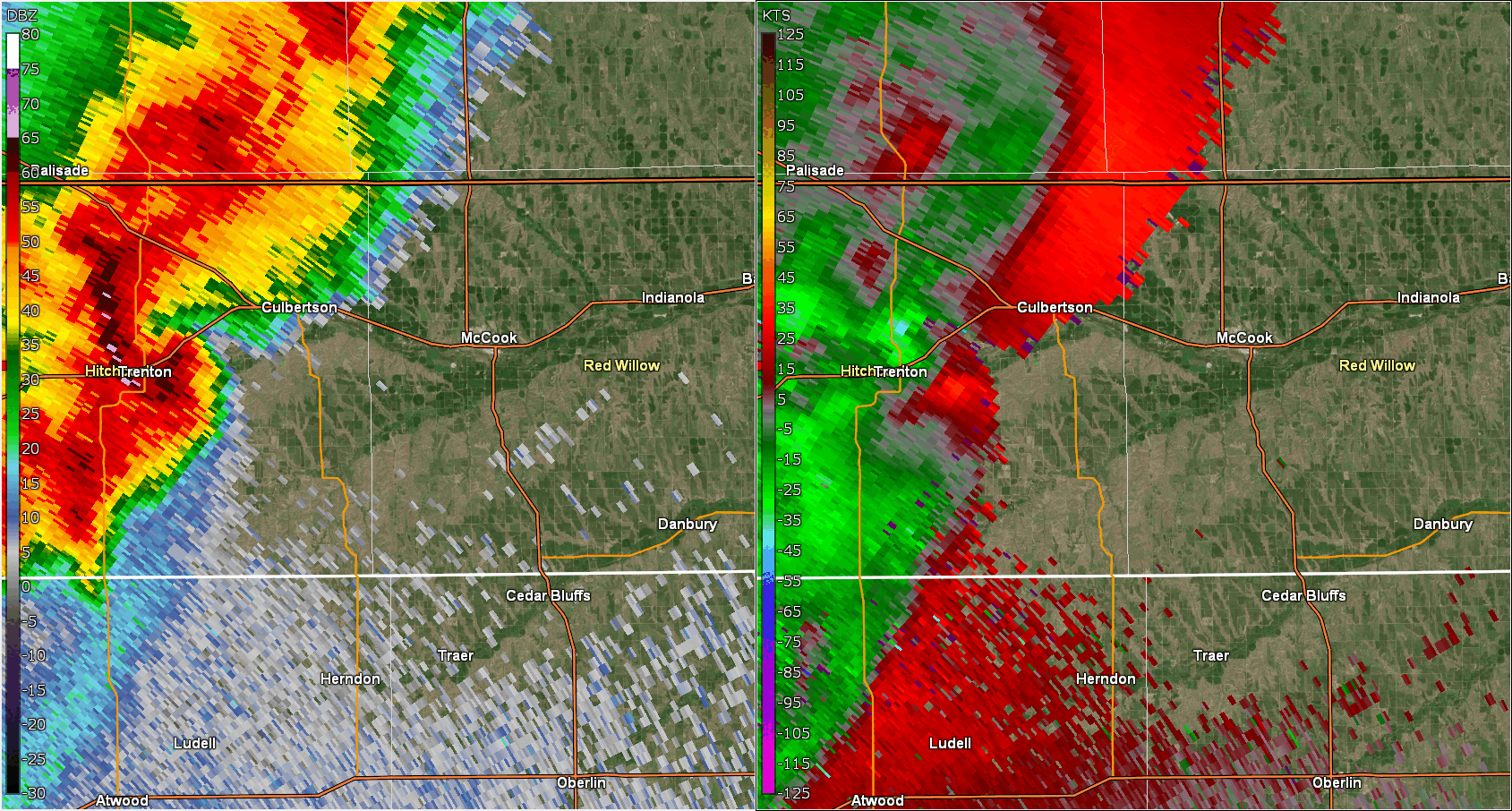 |
| Loop showing transition of supercell storm near Trenton into compact bow echo. |
Photos & Video
Trenton Tornado Damage
 |
 |
 |
 |
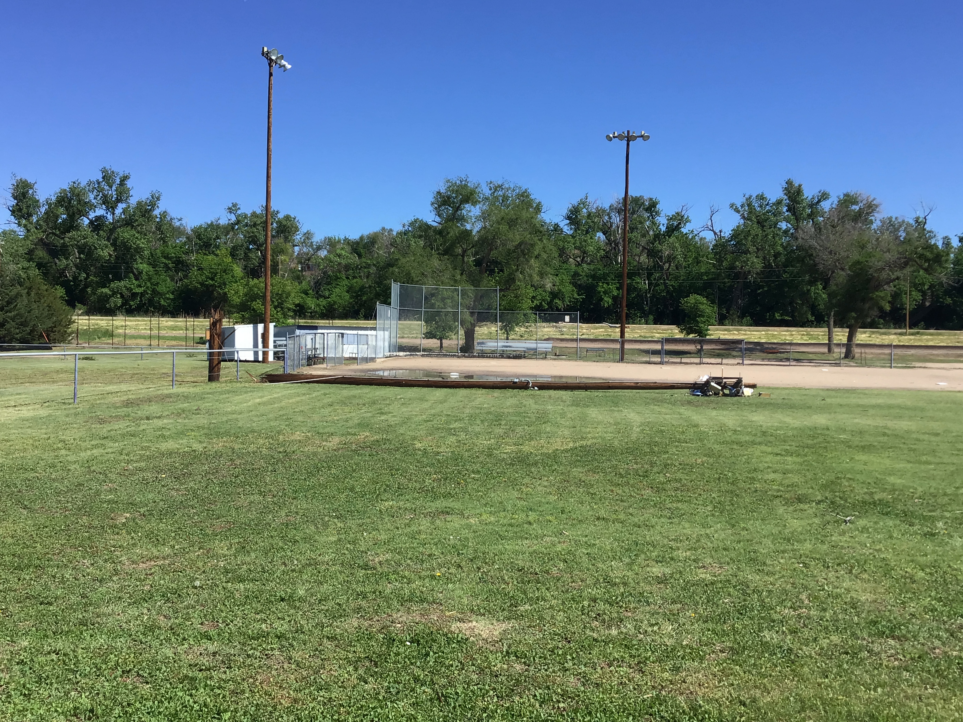
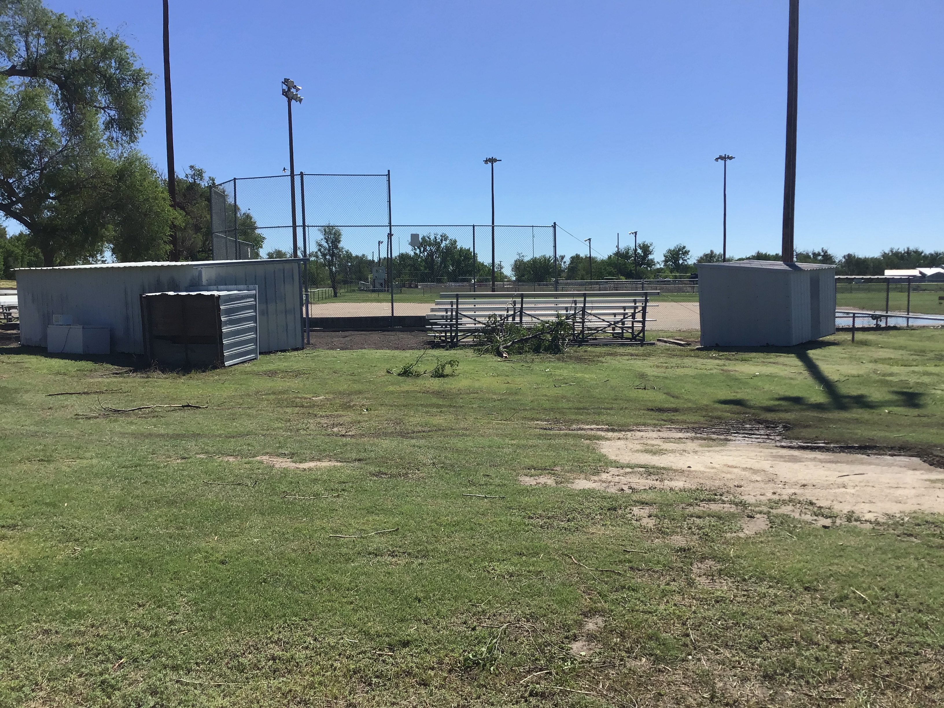
| Light pole snapped to the east at the baseball field. NWS Storm Survey |
Small sheds near the snapped light pole were flipped to the east. NWS Storm Survey |
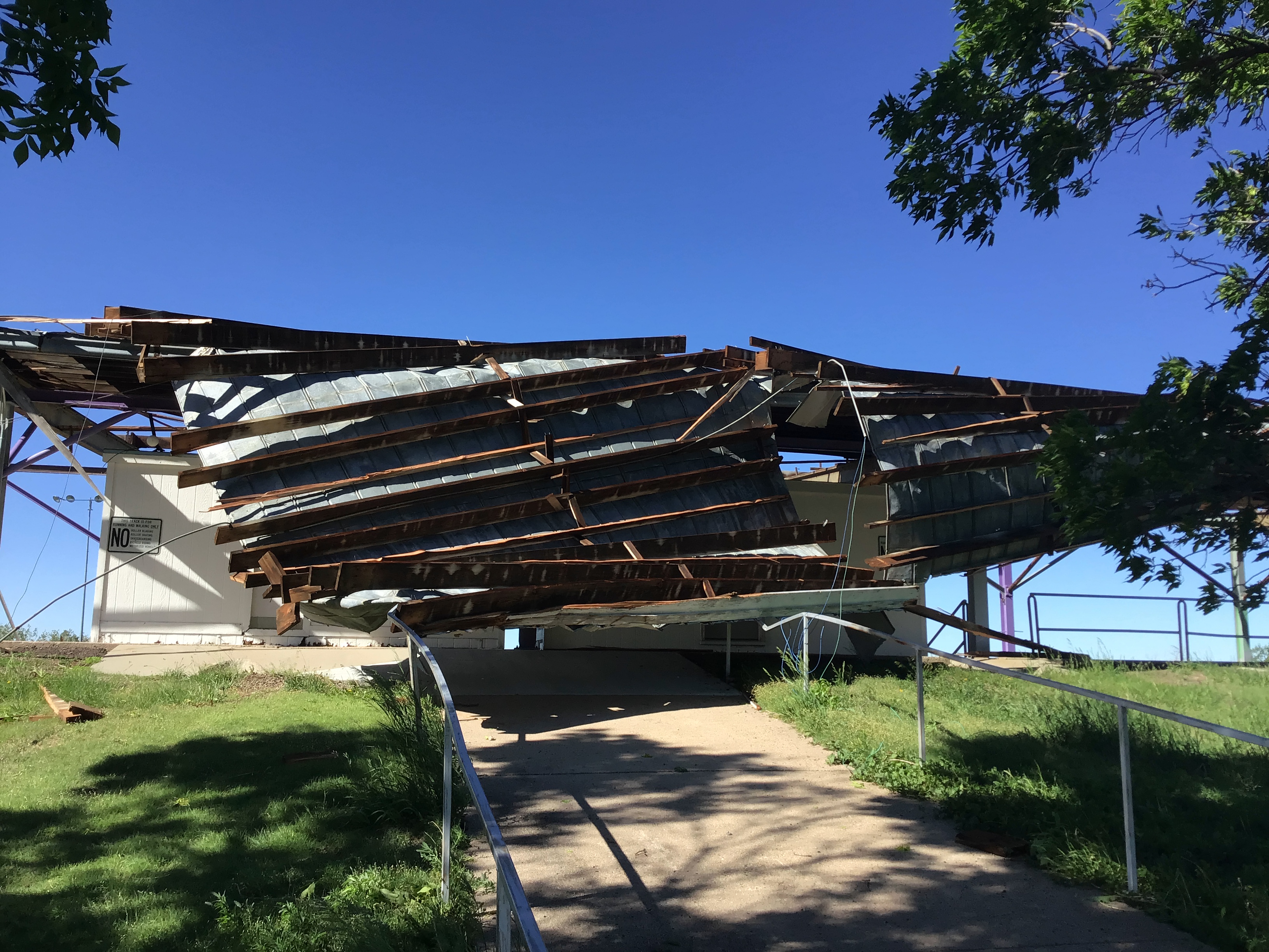
Stadium roof peeled to the east. Notice the hurdle still upright on the track. NWS Storm Survey |
Backside of the stadium looking west. NWS Storm Survey |
 |
 |
 |
 |
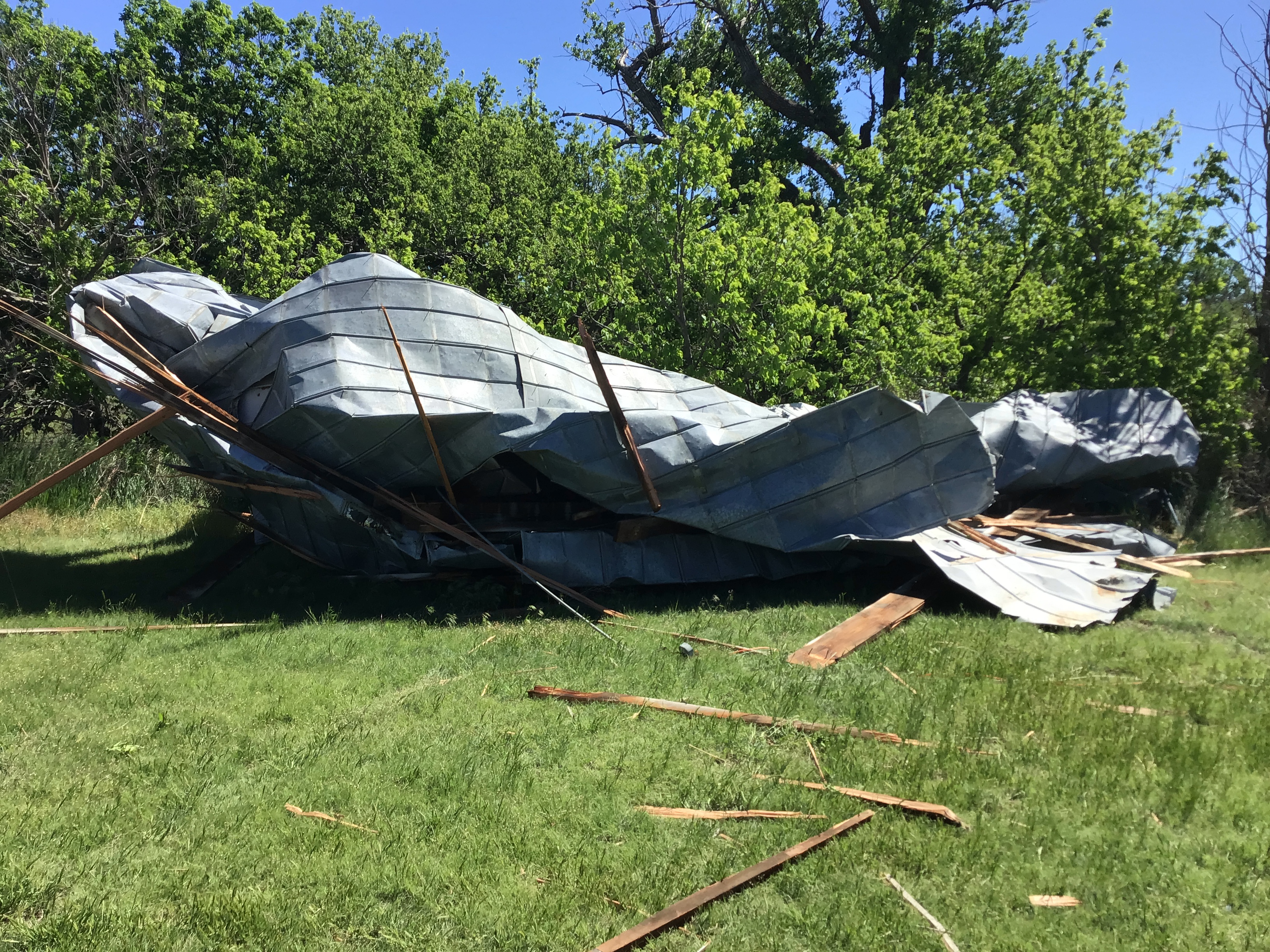
| Part of the stadium roof that was blown roughly 100 yards to the northeast. NWS Storm Survey |
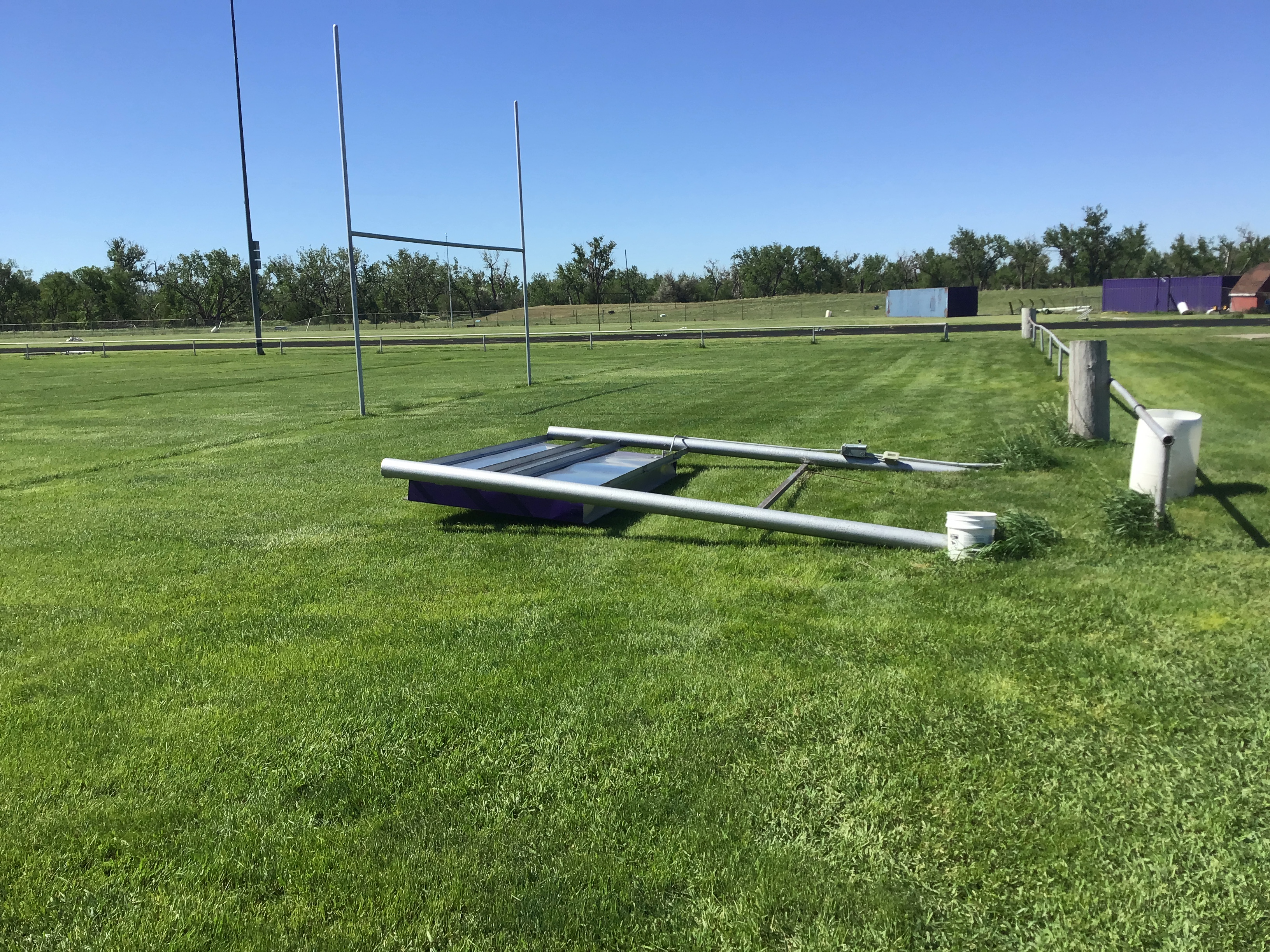
Scoreboard bent to the south. NWS Storm Survey |
Snapped trees south of the football field. This is near the end of the tornado track. NWS Storm Survey |
Snapped limbs northwest of the baseball field and across the road. This is approximate start of the tornado path. NWS Storm Survey |
McCook Straight-line Wind Damage
 |
 |
 |
 |
| Looking north five sets of double power poles snapped off. Power lines and pole debris blown to the east. NWS Storm Survey |
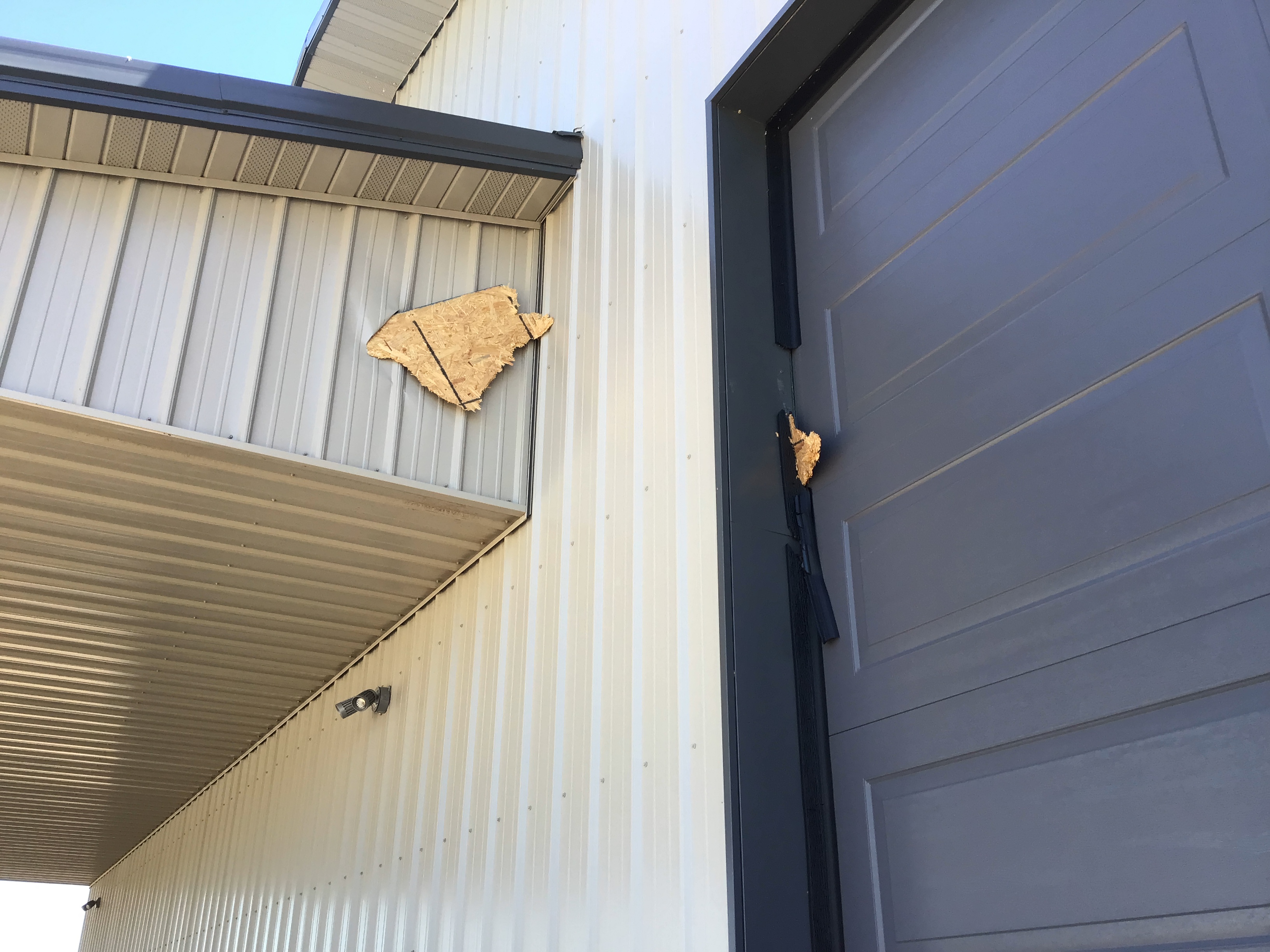
Two pieces of board driven into metal siding. This is on the south end of the snapped off power poles. NWS Storm Survey |
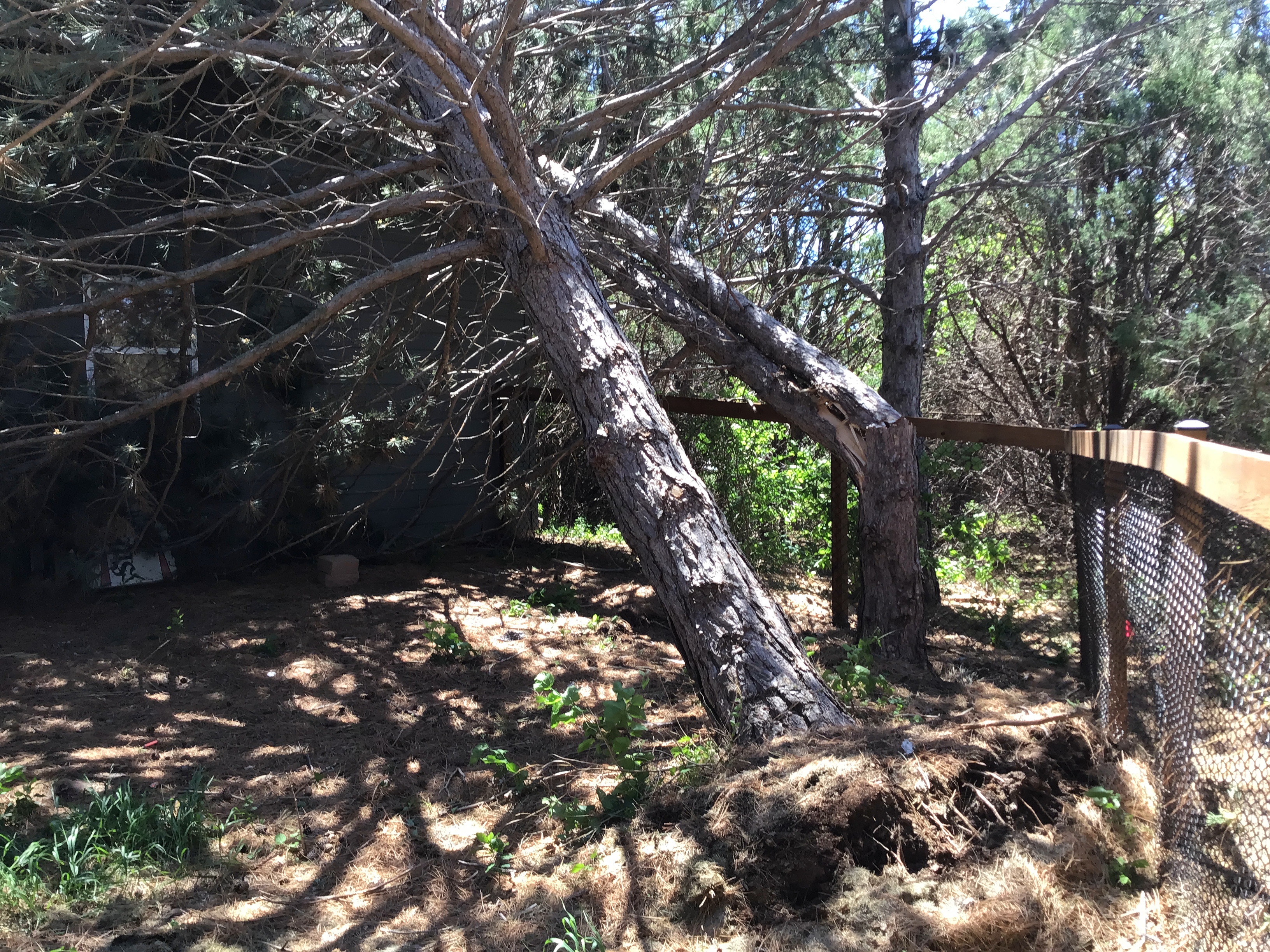
One pine tree uproot and and another snapped in Pearson Addition north of McCook. Many other trees were also snapped or uprooted. All of them were pointed in an easterly direction. NWS Storm Survey |
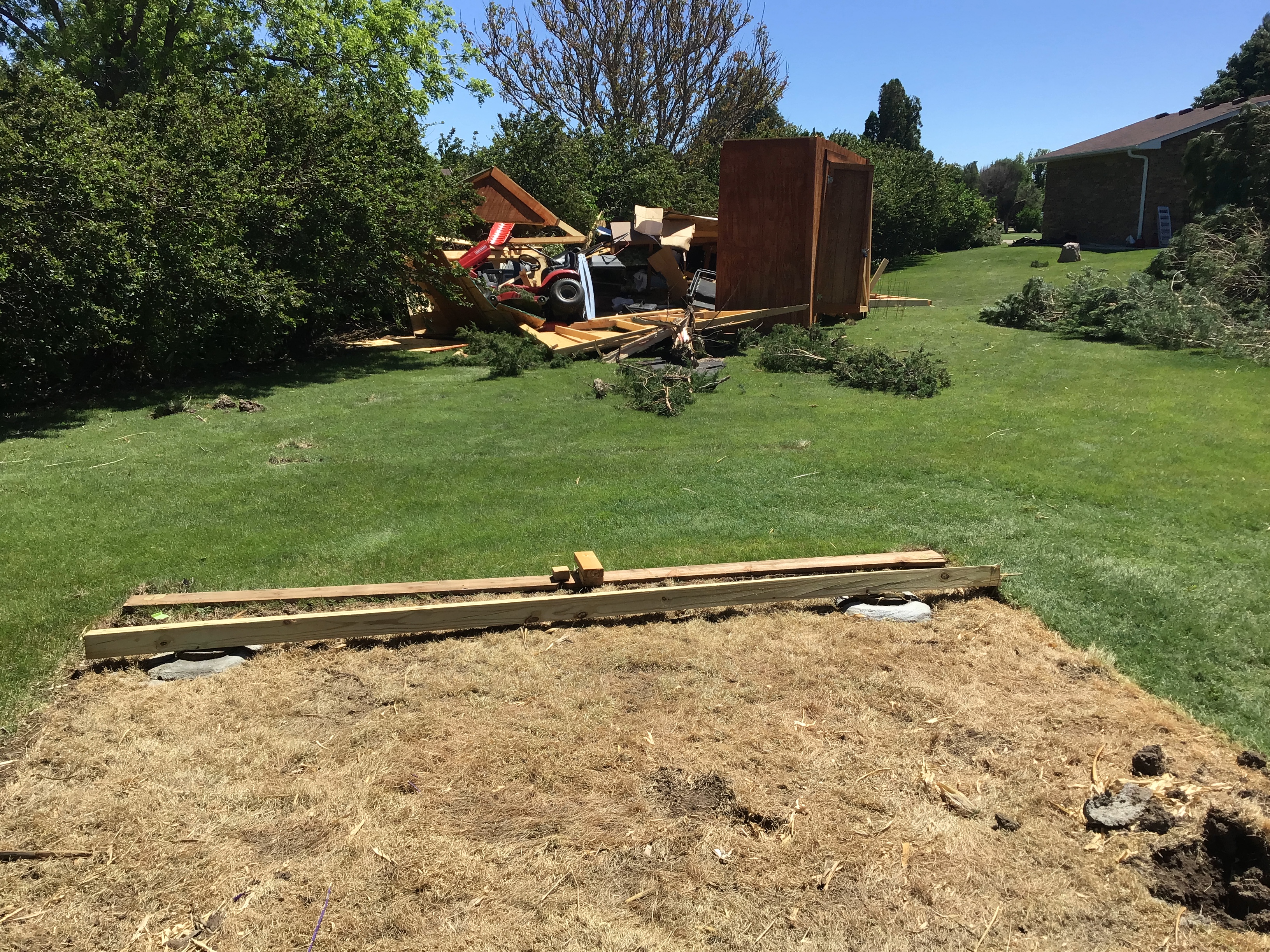
Small yard shed rolled to the ENE. This shed was anchored with four cement blocks that were buried. A mature pine tree, just out of frame to the right, was uprooted. Notice the unanchored well cover behind the tree is undisturbed. NWS Storm Survey |
Storm Reports
These reports are considered preliminary. Some details, such as specific times may be adjusted as new information is received and reports are quality controlled.
Preliminary Local Storm Report...Summary
National Weather Service Goodland KS
554 AM MDT Fri May 24 2024

..TIME...   ...EVENT...      ...CITY LOCATION...     ...LAT.LON...
..DATE...   ....MAG....      ..COUNTY LOCATION..ST.. ...SOURCE....
            ..REMARKS..

0809 PM     Tstm Wnd Gst     3 WNW Trenton           40.19N 101.08W
05/23/2024  E60 MPH          Hitchcock          NE   Trained Spotter


0954 PM     Tstm Wnd Gst     1 WSW Norton            39.83N 99.91W
05/23/2024  E60 MPH          Norton             KS   Trained Spotter

            estimated 50-60 mph wind gusts.

0943 PM     Tstm Wnd Gst     7 NE Oberlin            39.90N 100.44W
05/23/2024  M59 MPH          Decatur            KS   Mesonet

            Kansas mesonet site Oberlin 7NE.

0745 PM     Tstm Wnd Gst     19 NW Max               40.32N 101.62W
05/23/2024  M53 MPH          Dundy              NE   Mesonet

            Mesonet station NB086 Enders 10SW.

0815 PM     Tstm Wnd Gst     2 N Atwood              39.84N 101.04W
05/23/2024  M51 MPH          Rawlins            KS   Mesonet

            Mesonet station GW1727 ATWOOD.

0828 PM     Tstm Wnd Gst     6 SSE Culbertson        40.15N 100.78W
05/23/2024  M46 MPH          Hitchcock          NE   Mesonet

            Corrects previous non-tstm wnd gst report
            from 6 SSE Culbertson.

0818 PM     Tstm Wnd Dmg     6 NNW Stratton          40.23N 101.27W
05/23/2024                   Hitchcock          NE   Public

            Twitter picture of a flipped pivot.

0903 PM     Tstm Wnd Dmg     3 SSW Blakeman          39.78N 101.15W
05/23/2024                   Rawlins            KS   Law Enforcement

            Power pole down approx 7 miles west of
            Atwood near mile marker 47 on Highway 36.

0910 PM     Tstm Wnd Dmg     3 N Mccook              40.25N 100.62W
05/23/2024                   Red Willow         NE   Public

            Delayed report of storm damage. Partially
            constructed house has mostly collapsed.
            Neighbor shed was reported to be lifted and
            dropped. Time and location (3N McCook) are
            estimated.

0740 PM     Tornado          2 N Stratton            40.18N 101.23W
05/23/2024                   Hitchcock          NE   Fire Dept/Rescue

            Stratton fire dept relayed report of a
            tornado north of town... did have another
            video come in on X of rotating wall cloud.

0807 PM     Tornado          Trenton                 40.18N 101.01W
05/23/2024                   Hitchcock          NE   Trained Spotter

            Corrects previous tornado report from
            Trenton. Trees and power poles taken down.
            Tore the roof of a grandstand at a football
            field just west of town. Time estimated by
            radar.

0830 PM     Tornado          3 W Culbertson          40.23N 100.89W
05/23/2024                   Hitchcock          NE   Public

            still picture of tornado. 1/4 mile west of
            Perry grain. Crossed highway 6&34 and passed
            200 yards south of Perry at 930 ct. large
            10 tree branches broke off in the road
            where it crossed county road south of Perry.

0707 PM     Non-Tstm Wnd Gst 8 N Benkelman           40.16N 101.56W
05/23/2024  M62 MPH          Dundy              NE   Mesonet


0720 PM     Non-Tstm Wnd Gst 1 ENE Haigler           40.02N 101.92W
05/23/2024  M59 MPH          Dundy              NE   Mesonet


0849 PM     Non-Tstm Wnd Gst 1 NNE Goodland          39.37N 101.70W
05/23/2024  M59 MPH          Sherman            KS   ASOS


0909 PM     Non-Tstm Wnd Gst Firstview               38.82N 102.54W
05/23/2024  M59 MPH          Cheyenne           CO   Mesonet

            Mesonet station CO068 040w460 U40-Firstview.

0924 PM     Non-Tstm Wnd Gst 9 WSW Winona            39.00N 101.39W
05/23/2024  M58 MPH          Logan              KS   Mesonet

            Mesonet station UP840 9.0 W Winona (UPR).

0959 PM     Non-Tstm Wnd Gst 9 WSW Winona            39.00N 101.39W
05/23/2024  M58 MPH          Logan              KS   Mesonet

            Mesonet station UP840 9.0 W Winona (UPR).

0853 PM     Non-Tstm Wnd Gst 5 S Burlington          39.23N 102.28W
05/23/2024  M55 MPH          Kit Carson         CO   ASOS

            ASOS station KITR Burlington Co Airport.

0712 PM     Non-Tstm Wnd Gst 1 ENE Haigler           40.02N 101.92W
05/23/2024  M54 MPH          Dundy              NE   Mesonet


0828 PM     Non-Tstm Wnd Gst 15 N Selkirk            38.68N 101.54W
05/23/2024  M54 MPH          Wichita            KS   Mesonet


0955 PM     Non-Tstm Wnd Gst 3 N Colby               39.43N 101.05W
05/23/2024  M54 MPH          Thomas             KS   AWOS

            AWOS station KCBK 2 N Colby.

1000 PM     Non-Tstm Wnd Gst Leoti                   38.48N 101.36W
05/23/2024  M54 MPH          Wichita            KS   Mesonet

            Mesonet station FW1490 Leoti.

0615 PM     Non-Tstm Wnd Gst 2 SSE Yuma              40.10N 102.71W
05/23/2024  M53 MPH          Yuma               CO   AWOS

            53 mph wind gust and 7 SM visibilities
            observed with passage of cold front.

0918 PM     Non-Tstm Wnd Gst 2 NW Colby              39.41N 101.08W
05/23/2024  M53 MPH          Thomas             KS   Mesonet

            WUunderground station KKSCOLBY50.

0710 PM     Non-Tstm Wnd Gst 1 ENE Haigler           40.02N 101.92W
05/23/2024  M51 MPH          Dundy              NE   Mesonet


0817 PM     Non-Tstm Wnd Gst 4 S Burlington          39.24N 102.28W
05/23/2024  M51 MPH          Kit Carson         CO   ASOS


0826 PM     Non-Tstm Wnd Gst 3 W Bird City           39.76N 101.59W
05/23/2024  M51 MPH          Cheyenne           KS   Mesonet

            Mesonet station DW4654 Bird City.

0800 PM     Non-Tstm Wnd Gst Burlington              39.31N 102.27W
05/23/2024  E50 MPH          Kit Carson         CO   Public

            facebook report of estimated 50 mph winds
            along with 1000 feet to one quarter
            visibility due to blowing dust near open
            fields.

0822 PM     Non-Tstm Wnd Gst Aroya                   38.85N 103.13W
05/23/2024  M50 MPH          Cheyenne           CO   Mesonet

            Mesonet station UP695 Aroya (UPR).

0825 PM     Non-Tstm Wnd Gst 2 NNE Goodland          39.37N 101.70W
05/23/2024  M50 MPH          Sherman            KS   ASOS


0659 PM     Non-Tstm Wnd Gst 5 NE Vernon             39.98N 102.20W
05/23/2024  M49 MPH          Yuma               CO   Mesonet


0941 PM     Non-Tstm Wnd Gst 8 N Leoti               38.60N 101.37W
05/23/2024  M48 MPH          Wichita            KS   Mesonet


0629 PM     Non-Tstm Wnd Gst 3 NE Benkelman          40.09N 101.49W
05/23/2024  M47 MPH          Dundy              NE   Mesonet


0704 PM     Non-Tstm Wnd Gst 3 NNW Vernon            39.98N 102.30W
05/23/2024  M47 MPH          Yuma               CO   Mesonet


0755 PM     Non-Tstm Wnd Gst Saint Francis           39.76N 101.80W
05/23/2024  M47 MPH          Cheyenne           KS   AWOS


0846 PM     Non-Tstm Wnd Gst 14 S Burlington         39.10N 102.29W
05/23/2024  M47 MPH          Kit Carson         CO   Mesonet


0821 PM     Non-Tstm Wnd Gst 1 NW Joes               39.66N 102.69W
05/23/2024  M46 MPH          Yuma               CO   Mesonet


0820 PM     Non-Tstm Wnd Gst 10 N Goodland           39.49N 101.73W
05/23/2024  M45 MPH          Sherman            KS   Mesonet


0918 PM     Non-Tstm Wnd Gst 9 N Page City           39.21N 101.13W
05/23/2024  M45 MPH          Thomas             KS   Mesonet


0924 PM     Non-Tstm Wnd Dmg Wallace                 38.91N 101.59W
05/23/2024                   Wallace            KS   Public

            report of power getting knocked out in
            Wallace due to the winds from the cold
            front.

0808 PM     Hail             2 S Trenton             40.15N 101.01W
05/23/2024  E2.75 Inch       Hitchcock          NE   Fire Dept/Rescue

            One mile east of Swanson Reservoir Dam so
            around one or two miles SW of Trenton. Time
            estimated by radar.

0811 PM     Hail             3 WNW Trenton           40.18N 101.07W
05/23/2024  M1.75 Inch       Hitchcock          NE   Trained Spotter


0840 PM     Hail             Trenton                 40.17N 101.01W
05/23/2024  E1.50 Inch       Hitchcock          NE   Public

            facebook report of ping pong ball size hail.

0908 PM     Hail             Mccook                  40.21N 100.62W
05/23/2024  E1.25 Inch       Red Willow         NE   Public

            picture of 3 hail stones, one of the stones
            appears to be bigger than a quarter.

0903 PM     Hail             Mccook                  40.20N 100.62W
05/23/2024  E1.00 Inch       Red Willow         NE   Public

            facebook picture of quarter size hail.

0909 PM     Hail             Bartley                 40.25N 100.31W
05/23/2024  E1.00 Inch       Red Willow         NE   Public

            Corrects previous hail report from Bartley.
            Delayed report of dime to quarter sized hail
            in Bartley.

0911 PM     Hail             4 SW Bartley            40.21N 100.35W
05/23/2024  M1.00 Inch       Red Willow         NE   Trained Spotter

            Numerous pea to dime sized hail with a few
            quarters mixed in.

0922 PM     Hail             7 ENE Bartley           40.30N 100.20W
05/23/2024  E1.00 Inch       Red Willow         NE   Public

            Delayed report of mostly pea up to quarter
            sized hail 4 NW Cambridge.

0900 PM     Hail             Mccook                  40.20N 100.62W
05/23/2024  E0.88 Inch       Red Willow         NE   Public

            report via facebook of dime to nickel size
            hail.

0904 PM     Hail             7 N Indianola           40.34N 100.41W
05/23/2024  E0.70 Inch       Red Willow         NE   Public

            Dime and pea size hail 5 miles west of
            Bartley and 15 miles north of highway 36.
            Time estimated by radar.


&&

$$
 |
Media use of NWS Web News Stories is encouraged! Please acknowledge the NWS as the source of any news information accessed from this site. |
|