Widespread life-threatening flash and urban flooding continues in south-central Texas, with considerable flooding impacts possible across central Texas. Wildfire smoke is impacting air quality across much of the Great Lakes region into southern New England and the Mid-Atlantic. Monsoonal thunderstorms may produce isolated to scattered flash flooding across the Southwest into the Great Basin. Read More >
NOAA Weather Radio All-Hazards
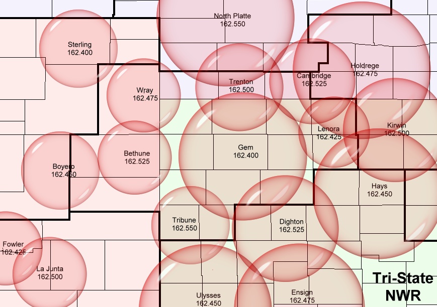
NOAA Weather Radio All-Hazards (NWR) is one of the backbones of the National Weather Service communications system. It is the easiest way for you to get around-the-clock weather information. Recordings are continuously updated at each National Weather Service office in the United States and broadcast from over 900 locations across the country. Each transmitter broadcasts current weather conditions, forecasts, special statements, and weather watches and warnings for a specific area. NWR is like having your own personal tornado siren right in your home...only it won't be quite that loud! For high impact events such as Severe Thunderstorm, Tornado and Flash Flood Warnings, each NWR transmitter will send a special digital code that activates receivers equipped with Specific Area Message Encoder (SAME) technology. This means that you can choose to receive only those alerts that will affect your county, or your surrounding counties. TransmittersThe local area is served by six separate NWR transmitters:
|
||||||||||||||||||||||||||||
|
|
||||||||||||||||||||||||||||
|
Weather Radio Codes
Click Here to see National Transmitter Information BroadcastsEach transmitter follows the following standard broadcast schedule:
During the morning hours, other forecasts and supplemental information are also available. Each transmitter carries a detailed daily climate summary and a roundup of high and low temperatures and 24 hour precipitation amounts from across the listening area. During the spring and summer months, a Hazardous Weather Outlook is broadcast which gives storm spotters, emergency managers and the general public a detailed look at expected severe weather conditions for the day. This includes expected time of storm development, movement, and the anticipated thunderstorm threats. When precipitation or other significant weather is occurring, Short Term Forecasts are broadcast before the seven-day forecast to give information on the type of precipitation, movement, and amount of rainfall (or snowfall) expected. Additionally, during severe weather, the routine broadcast will be interrupted to bring you the latest in real-time Watches, Statements, and Warnings in the Goodland County Warning Area. For More InformationIf you would like information about NOAA Weather Radio All-Hazards, or a brochure with all of the NWR frequencies, please Click Here!
|
||||||||||||||||||||||||||||